
GEOM-420 · Lesson 11 of 12 · 20 min
As-built surveys
When something is built, the design drawings stop being the best description of it. Pipes are moved to miss a rock, a footing is widened, a curve is adjusted in the field, and every element ends up a few millimeters or centimeters from its design position. An as-built survey records what was actually built, where and at what elevation. It is used to confirm that the work meets the specifications, to pay the contractor, to give the owner accurate records for operation and maintenance, and, years later, to give the next designer and the next locate crew a true picture of what is there. This lesson covers what to survey, when, how to compare it with the design, and how to deliver it.
Why as-builts matter
The district will operate the rebuilt headworks for fifty years or more. Its maintenance crews will need to know where the siphon's air valves are, how deep the pump station's discharge pipe is buried, where the buried power cable runs, and where the gate structure's anchors are. Its engineers will compare future monitoring results with the as-built geometry. And any utility locate request near the site will rely on the as-built record. A design drawing marked 'as built' with a few red-pen changes is not enough for any of this; what is needed is a survey of the finished work, in the project coordinate system, with known accuracy.
As-builts also protect everyone during the job. An as-built of the pump bases, measured before the pumps are delivered, tells the contractor and the engineer whether the bases are within tolerance while there is still time to fix them. An as-built of a pipe before it is backfilled shows its line and grade while it can still be seen. Once it is buried, the information can only be recovered by digging.
What and when to survey
The timing of as-built surveys is set by the construction sequence. Buried work must be surveyed before it is covered: pipe inverts and joints, valves, fittings, thrust blocks, utility crossings and the tops of buried structures. Structural elements must be surveyed when they are accessible: anchor bolts and bearing seats after the pour and before the steel or girders are placed, column positions and plumbness after erection. Surfaces are surveyed when they are finished: the road at each layer, the grading around the pump station, the canal lining.
The contract and the owner's standards define the content. Montana's highway projects and most municipal and district contracts specify what as-built information the contractor or the owner's surveyor must collect, in what format and to what accuracy, and FHWA's digital as-built initiative under Every Day Counts round 6 encouraged agencies to collect it as data rather than as marked-up drawings. Ruth's team prepares an as-built plan before construction starts, listing each element, when it will be surveyed, by whom and how, so that nothing is backfilled unrecorded.
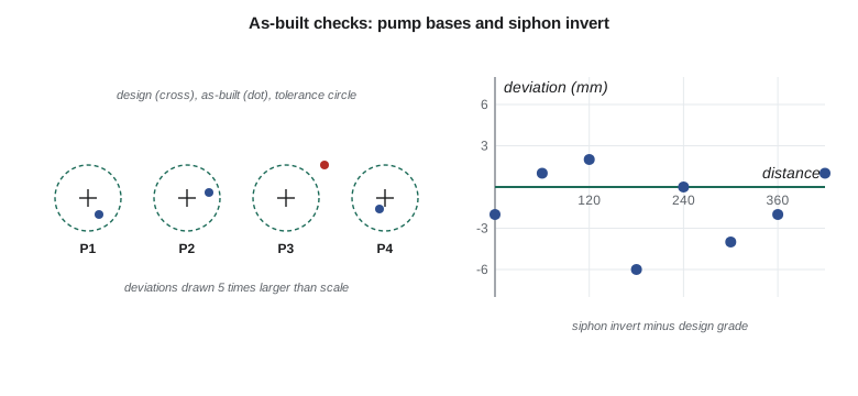
Comparing as-built with design
An as-built survey is most useful when it is compared with the design immediately, in the field or the same day. For each element, the deviation is the measured position minus the design position, in plan and in height, and it is compared with the tolerance for that element. Plan tolerances are often radial, a circle around the design point; height tolerances are usually plus or minus. Some tolerances are relative, such as the spacing between bolts in a group, and some are absolute, such as the position of the group on the grid.
import math
# As-built survey of the pump station and the siphon: deviations from design
U, u, dp, base = {'ca': (1000.0, 'mm', 1, 891.250), 'us': (1 / 0.3048, 'ft', 3, 1001.250)}['us']
# Anchor-bolt group positions for the four pump bases: design and as-built (E, N), m
design = {'P1': (5066.000, 3243.000), 'P2': (5072.000, 3243.000), 'P3': (5078.000, 3243.000), 'P4': (5084.000, 3243.000)}
asbuilt = {'P1': (5066.002, 3242.997), 'P2': (5072.004, 3243.001), 'P3': (5078.007, 3243.006), 'P4': (5083.999, 3242.998)}
tol = 0.006                                     # 6 mm radial tolerance from the pump supplier
for k in design:
    dE = asbuilt[k][0] - design[k][0]; dN = asbuilt[k][1] - design[k][1]; r = math.hypot(dE, dN)
    print(f"{k}: dE {dE*U:+.{dp}f}  dN {dN*U:+.{dp}f}  radial {r*U:.{dp}f} {u}  {'ok' if r <= tol else 'OUT - report to engineer'}")
# Siphon invert at joints: design grade falling 0.20 % from the inlet, as-built rod shots every 60 m (heights in m)
inv_design = lambda x: base - 0.0020 * x
shots = [(x, base + d) for x, d in ((0, -0.002), (60, -0.119), (120, -0.238), (180, -0.366), (240, -0.480), (300, -0.604), (360, -0.722), (420, -0.839))]
dev = [z - inv_design(x) for x, z in shots]
for (x, z), d in zip(shots, dev):
    print(f"  {x*U/1000 if u == 'mm' else x*U:7.1f} {'m' if u == 'mm' else 'ft'}: invert {z*(1 if u == 'mm' else U):.3f}  deviation {d*U:+.{dp}f} {u}")
worst = max(dev, key=abs)
slope = (shots[-1][1] - shots[0][1]) / shots[-1][0]
print(f"largest deviation {worst*U:+.{dp}f} {u}; as-built average grade {100*slope:.3f} % (design -0.200 %)")P1: dE +0.007 dN -0.010 radial 0.012 ft ok
P2: dE +0.013 dN +0.003 radial 0.014 ft ok
P3: dE +0.023 dN +0.020 radial 0.030 ft OUT - report to engineer
P4: dE -0.003 dN -0.007 radial 0.007 ft ok
0.0 ft: invert 3284.934 deviation -0.007 ft
196.9 ft: invert 3284.551 deviation +0.003 ft
393.7 ft: invert 3284.160 deviation +0.007 ft
590.6 ft: invert 3283.740 deviation -0.020 ft
787.4 ft: invert 3283.366 deviation +0.000 ft
984.3 ft: invert 3282.959 deviation -0.013 ft
1181.1 ft: invert 3282.572 deviation -0.007 ft
1378.0 ft: invert 3282.188 deviation +0.003 ft
largest deviation -0.020 ft; as-built average grade -0.199 % (design -0.200 %)Three of the four pump bases are within the supplier's 0.020 ft (6 mm) radial tolerance, but P3 is 0.030 ft from its design position, 0.023 ft east and 0.020 ft north. That must be reported to the engineer at once, before the pump arrives: the fix may be as simple as slotting the base plate holes, or it may need new anchors. The siphon inverts, surveyed through the pipe at each joint group, are within 0.020 ft of the design grade everywhere, and the average grade is −0.199 % against a design of −0.200 %. For a gravity pipe with this grade, a 0.02 ft low spot is well within what the hydraulics can tolerate, and the engineer accepts it.
The output also shows something about the method. Deviations of a few millimeters are close to the precision of the as-built measurement itself. The crew uses a total station with forced centering on the pump bases and repeats each shot, so that the measurement precision is about 1 mm; a deviation of 9.2 mm is then clearly real, while one of 2 mm is near the limit of what can be said. An as-built survey must be several times more precise than the tolerance it is checking, for the same reason that a monitoring survey must be more precise than the movement it is looking for.
Worked problem
Is a bolt group in tolerance?
A bolt group's design position is E 8200.000, N 3940.000. The as-built is E 8200.013, N 3939.987. The radial tolerance is 0.016 ft. Is it acceptable?
Show solution
- \[\Delta E = +0.013 \qquad \Delta N = -0.013\ \text{ft}\]
- \[r = \sqrt{0.013^2 + 0.013^2} = 0.018\ \text{ft} > 0.016\ \text{ft}\]
Answer: No. Each component alone looks small, but the radial deviation exceeds the tolerance.
Surveying buried utilities as they are installed
The best moment to record a buried utility is with the trench open and the pipe or cable exposed. The crew shoots the top of pipe or invert at each joint, bend, fitting and valve, and at regular intervals between, plus the locations of tracer wire, markers and any crossings with other utilities. Each point gets a code identifying the utility, its size and material, and the feature. This is quality level A information in the sense of Lesson 1, and it is far more valuable than any later locate. A growing number of owners now require it, and the ASCE standard for recording utilities exposed during construction gives a framework for what to collect.
The pump station's buried power cable, for example, was rerouted during construction to avoid a footing. The crew surveyed it in the open trench every few meters and at both bends, with its depth, before backfill. The district's records now show the real route, not the design route, and the next crew digging nearby will find it where the drawing says.
Surfaces and quantities
Finished surfaces are surveyed as terrain models, like the design survey of Lesson 1, and compared with the design surfaces. For the highway, the as-built of each layer is a grid of shots or a mobile lidar run (GEOM-350), compared with the design layer to show thickness and smoothness. For the pump station grading, a drone survey gives a surface that is compared with design to check drainage slopes away from the building. The same surfaces give final quantities for payment, as Lesson 4 described.
Machine-control logs from Lesson 6 can contribute, but they are a record of where the blade was, so they are used as a guide and checked by independent shots. The as-built record says which method produced each surface and how it was checked.
Deliverables
An as-built package includes a report, drawings or a model, and data. The report describes what was surveyed, when, by whom, with what equipment, in what coordinate system and to what accuracy, and lists every deviation beyond tolerance with its resolution. The drawings or model show the as-built geometry, ideally as a separate layer from the design so that differences are visible. The data are delivered in the owner's required formats, with attributes for each feature, ready to load into the district's GIS and asset management system, as GEOM-330 described.
Digital as-builts are replacing the old practice of red-lined paper. A model in which each pipe, valve and structure is an object with its attributes and its surveyed geometry can be queried, updated and used by everyone from the operator to the next designer. The surveyor's responsibility is that the geometry is right, documented and in the right coordinate system, because a beautiful model in the wrong datum is a trap for everyone who uses it.
Road and canal as-builts
For the highway, the as-built record has to serve two very different users. The transportation department needs to know the finished alignment, the pavement surface, the location of the drainage features and the signs, so that it can maintain the road and plan future work. The district needs to know where the road crosses its canal and its pipes, with the bridge's as-built geometry and the clearances. So the as-built package includes the finished centerline and edges of pavement, the drainage features with their inverts, the bridge deck and bearing positions, and the vertical clearance from the canal's design water level to the underside of the girders at each girder line.
The canal lining near the pump station was partly rebuilt, and its as-built is a set of cross-sections every 50 ft, surveyed after the concrete was placed, compared with the design sections to confirm the bottom width, side slopes and grade. Because canal capacity depends on these numbers, the district's engineer reviews them before the canal is put back into service.
Who does the as-built, and how it is checked
Contracts divide as-built responsibility in different ways. Sometimes the contractor's surveyor collects the as-built data and the owner's surveyor checks a sample; sometimes the owner's surveyor does it all; sometimes the contractor supplies red-lined drawings and the owner's surveyor surveys the key items. On the headworks job, the contractor surveys buried utilities and pipes as they go in, because its crews are there when the trench is open, and Coulee Geomatics checks a sample of those shots and surveys the structures, the bridge and the finished surfaces itself. The sample checks use the same statistics as Lesson 12.
Whatever the split, the as-built must use the project control and the project coordinate system, and its metadata must say who surveyed each item. Mixing data from two firms is common on large jobs, and it works only when both firms work from the same control and the same definitions.
Common mistakes
MistakeBackfilling before surveying buried work.
InsteadSurvey pipes, valves and cables while the trench is open.
MistakeChecking each coordinate separately against a radial tolerance.
InsteadCompute the radial deviation and compare it with the radial tolerance.
MistakeUsing an as-built method no more precise than the tolerance.
InsteadMake the measurement several times more precise than the tolerance.
MistakeDelivering marked-up design drawings as the as-built.
InsteadDeliver surveyed geometry and data in the project coordinate system.
Summary and key terms
- An as-built survey records what was built, for acceptance, payment, operation and future work.
- Timing follows construction: buried work before backfill, structures before the next stage, surfaces when finished.
- Deviations are compared with plan (often radial) and height tolerances immediately.
- The as-built measurement must be much more precise than the tolerance.
- Utilities recorded in the open trench are the most reliable records an owner can have.
- Deliverables include a report, drawings or a model, and attributed data in the project system.
- As-built survey
- A survey of completed work showing its actual position and elevation.
- Deviation
- The difference between the as-built and design position or elevation.
- Radial tolerance
- A permitted plan deviation expressed as a circle around the design point.
- Invert
- The inside bottom of a pipe or channel.
- Digital as-built
- An as-built record delivered as attributed data and models rather than marked-up drawings.
- Tracer wire
- A wire laid with a non-metallic pipe so that it can be located later.
- Asset management system
- An owner's database of infrastructure and its condition, used for maintenance and planning.
Practice problems
Work each problem on paper first, then reveal the answer to check.
A point is 0.010 ft east and 0.016 ft south of design. What is its radial deviation?
Show answer
√(0.010² + 0.016²) = 0.019 ft.
Why is it important to survey a pipe before backfill?
Show answer
Afterwards its position can be recovered only by locating or digging.
An as-built shows a deviation of 2 mm with a measurement precision of 1.5 mm. What can be said?
Show answer
Little; the deviation is close to the measurement noise.
What should an as-built report say about each out-of-tolerance item?
Show answer
The deviation, the tolerance and how it was resolved.
Why is a model in the wrong datum dangerous?
Show answer
Everyone who uses it will locate features in the wrong place.
Lesson quiz · 5 questions
Score 60% or more to complete this lesson.
Create a free account to save your progress, take quizzes and earn a certificate.