
GEOM-340 · Lesson 7 of 12 · 25 min
State plane coordinate systems
In the United States, each state has its own official plane coordinate system, defined in state law and designed by the National Geodetic Survey (NGS). The State Plane Coordinate System (SPCS) has been the framework for engineering, surveying and land records in most states for nearly a century, and it is about to change for the first time since 1983. This lesson describes how SPCS was designed, the zones in Montana and its neighbors, the units problem that has caused more errors than any projection formula, and the State Plane Coordinate System of 2022 (SPCS2022) that will accompany the modernized National Spatial Reference System.
Origins: SPCS 27
The system began in 1933, when the US Coast and Geodetic Survey designed a plane coordinate system for North Carolina at the request of a highway engineer who wanted surveys tied to the national control network without the burden of geodetic computation. The idea spread quickly, and by the late 1930s every state had a system. The goal was a maximum scale error of 1 part in 10,000 (100 ppm), small enough that surveyors could use plane trigonometry with a single correction. To achieve it, states long in the north-south direction were given transverse Mercator zones and states long in the east-west direction Lambert conformal conic zones, and larger states were divided into several zones. These SPCS 27 zones were defined on NAD27 in US survey feet, and many old plats, deeds and highway plans still carry their coordinates.
SPCS 83
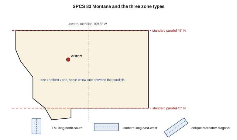
With the adoption of NAD83, NGS redefined the zones as SPCS 83, with defining parameters in meters. Most zones kept their SPCS 27 geometry with new false origins, so that SPCS 83 coordinates are clearly distinguishable from SPCS 27 ones, and some states took the opportunity to change their zones. Montana, which had three Lambert zones under SPCS 27 (North, Central and South), adopted a single statewide Lambert zone, identified as zone 2500, with standard parallels at 45° N and 49° N, an origin at 44°15' N and 109°30' W, a false easting of 600,000 m and a false northing of zero. A single zone simplified statewide data and land records at the cost of distortion up to about 600 ppm in the middle of the state, larger than the 1933 design goal. Idaho kept three transverse Mercator zones and Wyoming four; North Dakota and South Dakota kept two Lambert zones each.
| Zone type | Shape of state or zone | Examples in SPCS 83 | Lines of zero distortion |
|---|---|---|---|
| Transverse Mercator | Long north-south | Idaho (3 zones), Wyoming (4), Arizona (3) | Two lines parallel to the central meridian |
| Lambert conformal conic | Long east-west | Montana (1 zone), North Dakota (2), Kansas (2) | Two standard parallels |
| Oblique Mercator | Long diagonal | Alaska zone 1 (the panhandle) | Two lines parallel to the skew axis |
| Single statewide zone | Any; accepts more distortion | Montana, Nebraska, South Carolina | Depends on projection |
The foot problem
SPCS 83 was defined in meters, but most users work in feet, and there were two feet. The US survey foot, defined in 1893 as 1200/3937 m, was used for geodetic surveying; the international foot of exactly 0.3048 m, adopted in 1959 for all other purposes, is shorter by 2 parts per million. Each state chose by law which foot to use with SPCS 83, and a few, Montana among them, chose the international foot. Two ppm sounds negligible, but state plane coordinates are millions of feet: at 1.5 million feet the difference is 3 ft, enough to put a property corner in the neighbor's yard or a culvert in the wrong place. Software that converts a Montana file using the wrong foot moves every point by several feet in a direction away from the false origin. To end the confusion, NIST and NGS deprecated the US survey foot at the end of 2022, and SPCS2022 uses the international foot wherever feet are used.
import math
a = 6378137.0; f = 1 / 298.257222101; e = math.sqrt(f * (2 - f))   # GRS80

def _m(p): return math.cos(p) / math.sqrt(1 - (e * math.sin(p)) ** 2)
def _t(p): return math.tan(math.pi / 4 - p / 2) / ((1 - e * math.sin(p)) / (1 + e * math.sin(p))) ** (e / 2)

class LCC:
    """Lambert conformal conic with two standard parallels (degrees, m)."""
    def __init__(self, lat1, lat2, lat0, lon0, fe=0.0, fn=0.0):
        p1, p2, p0 = map(math.radians, (lat1, lat2, lat0))
        self.n = (math.log(_m(p1)) - math.log(_m(p2))) / (math.log(_t(p1)) - math.log(_t(p2)))
        self.F = _m(p1) / (self.n * _t(p1) ** self.n)
        self.r0 = a * self.F * _t(p0) ** self.n
        self.lon0, self.fe, self.fn = lon0, fe, fn
    def forward(self, lat, lon):
        p = math.radians(lat); r = a * self.F * _t(p) ** self.n
        th = self.n * math.radians(lon - self.lon0)
        E = self.fe + r * math.sin(th); N = self.fn + self.r0 - r * math.cos(th)
        k = r * self.n / (a * _m(p))                  # point scale factor
        return E, N, k, math.degrees(th)               # th is the grid convergence
    def inverse(self, E, N):
        dx, dy = E - self.fe, self.r0 - (N - self.fn)
        r = math.copysign(math.hypot(dx, dy), self.n); th = math.atan2(dx, dy)
        t = (r / (a * self.F)) ** (1 / self.n); p = math.pi / 2 - 2 * math.atan(t)
        for _ in range(30):
            pn = math.pi / 2 - 2 * math.atan(t * ((1 - e * math.sin(p)) / (1 + e * math.sin(p))) ** (e / 2))
            if abs(pn - p) < 1e-15: break
            p = pn
        return math.degrees(p), self.lon0 + math.degrees(th / self.n)
import math
A_GRS80 = 6378137.0
F_GRS80 = 1 / 298.257222101

def tm_setup(a=A_GRS80, f=F_GRS80):
    n = f / (2 - f)
    A = a / (1 + n) * (1 + n**2 / 4 + n**4 / 64 + n**6 / 256)
    al = [n/2 - 2*n**2/3 + 5*n**3/16 + 41*n**4/180 - 127*n**5/288 + 7891*n**6/37800,
          13*n**2/48 - 3*n**3/5 + 557*n**4/1440 + 281*n**5/630 - 1983433*n**6/1935360,
          61*n**3/240 - 103*n**4/140 + 15061*n**5/26880 + 167603*n**6/181440,
          49561*n**4/161280 - 179*n**5/168 + 6601661*n**6/7257600,
          34729*n**5/80640 - 3418889*n**6/1995840,
          212378941*n**6/319334400]
    be = [n/2 - 2*n**2/3 + 37*n**3/96 - n**4/360 - 81*n**5/512 + 96199*n**6/604800,
          n**2/48 + n**3/15 - 437*n**4/1440 + 46*n**5/105 - 1118711*n**6/3870720,
          17*n**3/480 - 37*n**4/840 - 209*n**5/4480 + 5569*n**6/90720,
          4397*n**4/161280 - 11*n**5/504 - 830251*n**6/7257600,
          4583*n**5/161280 - 108847*n**6/3991680,
          20648693*n**6/638668800]
    e = math.sqrt(f * (2 - f))
    return n, A, al, be, e

def tm_forward(lat, lon, lon0, k0, fe=0.0, fn=0.0, a=A_GRS80, f=F_GRS80):
    """Geodetic latitude and longitude (degrees) to TM easting, northing,
    point scale factor k and grid convergence gamma (degrees)."""
    n, A, al, be, e = tm_setup(a, f)
    phi = math.radians(lat); dl = math.radians(lon - lon0)
    t = math.sinh(math.atanh(math.sin(phi)) - e * math.atanh(e * math.sin(phi)))
    xi1 = math.atan2(t, math.cos(dl)); eta1 = math.atanh(math.sin(dl) / math.sqrt(1 + t * t))
    xi, eta = xi1, eta1; p, q = 1.0, 0.0
    for j in range(1, 7):
        xi += al[j-1] * math.sin(2*j*xi1) * math.cosh(2*j*eta1)
        eta += al[j-1] * math.cos(2*j*xi1) * math.sinh(2*j*eta1)
        p += 2*j*al[j-1] * math.cos(2*j*xi1) * math.cosh(2*j*eta1)
        q += 2*j*al[j-1] * math.sin(2*j*xi1) * math.sinh(2*j*eta1)
    E = fe + k0 * A * eta; N = fn + k0 * A * xi
    k = k0 * A / a * math.sqrt(1 + ((1 - n) / (1 + n) * math.tan(phi))**2) * math.sqrt(p*p + q*q) / math.sqrt(t*t + math.cos(dl)**2)
    g1 = math.atan2(t * math.tan(dl), math.sqrt(1 + t*t))
    g2 = math.atan2(q, p)
    return E, N, k, math.degrees(g1 + g2)

def tm_inverse(E, N, lon0, k0, fe=0.0, fn=0.0, a=A_GRS80, f=F_GRS80):
    """TM easting and northing back to latitude and longitude (degrees)."""
    n, A, al, be, e = tm_setup(a, f)
    xi = (N - fn) / (k0 * A); eta = (E - fe) / (k0 * A)
    xi1, eta1 = xi, eta
    for j in range(1, 7):
        xi1 -= be[j-1] * math.sin(2*j*xi) * math.cosh(2*j*eta)
        eta1 -= be[j-1] * math.cos(2*j*xi) * math.sinh(2*j*eta)
    chi = math.asin(math.sin(xi1) / math.cosh(eta1))
    lam = math.atan2(math.sinh(eta1), math.cos(xi1))
    t0 = math.tan(chi); t = t0
    for _ in range(10):
        sig = math.sinh(e * math.atanh(e * t / math.sqrt(1 + t*t)))
        tp = t * math.sqrt(1 + sig*sig) - sig * math.sqrt(1 + t*t)
        dt = (t0 - tp) / math.sqrt(1 + tp*tp) * (1 + (1 - e*e) * t*t) / ((1 - e*e) * math.sqrt(1 + t*t))
        t += dt
        if abs(dt) < 1e-14: break
    return math.degrees(math.atan(t)), lon0 + math.degrees(lam)

def dms(x):
    s = '-' if x < 0 else ''; x = abs(x); d = int(x); m = int((x - d) * 60); sec = ((x - d) * 60 - m) * 60
    if sec >= 59.99995: sec -= 60; m += 1
    if m == 60: m = 0; d += 1
    return f"{s}{d}°{m:02d}'{sec:07.4f}\""

US_FT = 1200 / 3937          # the US survey foot, in m (retired after 2022)
INT_FT = 0.3048              # the international foot, in m

lat, lon = 47.50600422, -111.29779092          # pillar CR1, Great Falls
mt = LCC(49, 45, 44.25, -109.5, 600000, 0)     # SPCS 83 Montana (2500), a Lambert zone
E, N, k, g = mt.forward(lat, lon)
print(f"SPCS 83 Montana:  E = {E:.3f} m  N = {N:.3f} m  k = {k:.7f}  convergence {g:+.4f} deg")
print(f"  international feet: E = {E/INT_FT:.3f}  N = {N/INT_FT:.3f}")
print(f"  US survey feet:     E = {E/US_FT:.3f}  N = {N/US_FT:.3f}")
print(f"  using the wrong foot moves the point {(E/INT_FT - E/US_FT):.3f} ft east and "
      f"{(N/INT_FT - N/US_FT):.3f} ft north (2 parts per million of the coordinate)")

# A transverse Mercator state plane zone for comparison: Idaho Central (SPCS 83)
iE, iN, ik, ig = tm_forward(lat, lon, -114.0, 1 - 1/19000, 500000.0, 0.0)
print(f"\nThe same point on a TM zone with k0 = 1 - 1/19000 and central meridian 114 W:")
print(f"  E = {iE:.3f} m  k = {ik:.7f}  (an example of a zone used outside its area)")

print("\nMontana zone scale at the latitude of CR1 and in the district:")
for L in (47.3, 47.4, 47.5, 47.6, 47.7):
print(f" latitude {L}: k = {mt.forward(L, -111.3)[2]:.7f} ({(mt.forward(L, -111.3)[2]-1)*1e6:+7.1f} ppm)")SPCS 83 Montana: E = 464652.589 m N = 363352.692 m k = 0.9994297 convergence -1.3151 deg international feet: E = 1524450.750 N = 1192102.008 US survey feet: E = 1524447.701 N = 1192099.624 using the wrong foot moves the point 3.049 ft east and 2.384 ft north (2 parts per million of the coordinate) The same point on a TM zone with k0 = 1 - 1/19000 and central meridian 114 W: E = 703553.631 m k = 1.0004564 (an example of a zone used outside its area) Montana zone scale at the latitude of CR1 and in the district: latitude 47.3: k = 0.9994052 ( -594.8 ppm) latitude 47.4: k = 0.9994155 ( -584.5 ppm) latitude 47.5: k = 0.9994288 ( -571.2 ppm) latitude 47.6: k = 0.9994452 ( -554.8 ppm) latitude 47.7: k = 0.9994646 ( -535.4 ppm)
CR1 has Montana state plane coordinates of E 464,652.589 m and N 363,352.692 m, or 1,524,450.750 ft and 1,192,102.008 ft in international feet. The same meters expressed in US survey feet are 3.05 ft smaller in easting and 2.38 ft smaller in northing. The point scale factor at CR1 is 0.9994297, 570 ppm short, and across the district the scale runs from −595 to −535 ppm, so a 1,000 ft grid distance corresponds to about 1,000.57 ft on the ellipsoid before height is considered. Projected on a transverse Mercator zone meant for central Idaho, the same point has a scale factor of 1.00046, an example of how quickly distortion grows when a zone is used outside its area.
SPCS2022
NGS is replacing NAD83 and NAVD 88 with the modernized National Spatial Reference System, including the North American Terrestrial Reference Frame of 2022 (NATRF2022) described in lesson 10, and SPCS2022 is the plane coordinate system that goes with it. Its design differs from SPCS 83 in several ways. Each state may have a statewide zone, for those who want one system for the whole state, and in many states a layer of smaller low-distortion zones designed with local surveyors, engineers and GIS users. Zones are designed to minimize distortion at the topographic surface rather than on the ellipsoid, so that grid distances in populated areas are close to ground distances, as lesson 8 explains. All zones are defined in meters, and feet, where used, are international feet. Zone parameters were developed with the states and published by NGS on its development websites; SPCS2022 becomes official with the rest of the modernized NSRS, after a beta period in which NGS released the new tools for public testing.
For a practitioner in Montana, this means that coordinates in the coming years will exist in at least three forms: SPCS 27 on NAD27 in the oldest records, SPCS 83 on one of several NAD83 realizations, and SPCS2022 on NATRF2022. The numbers in each will be different, and a coordinate without its system, datum, realization, epoch and unit is not usable for precise work. The district's data standard therefore records all of these for every coordinate set.
Choosing a system for the district
Leah's recommendation followed the uses. The GIS master data remained on SPCS 83 Montana in international feet on NAD83(2011), shared with the county's parcel data and the state's cadastral layer. Survey control and legal surveys would also be reported on SPCS 83, with grid distances converted to ground distances by the combined factor of lesson 8, until the state adopts SPCS2022. Engineering design for the canal rehabilitation, where contractors stake from coordinates with total stations and expect grid distances to agree with measured distances, would use a low-distortion projection designed for the district, which lesson 8 also describes, with a documented transformation from state plane. Federal data arriving in UTM zone 12 would be transformed on load. Each choice was written into the district's data standard with its EPSG code where one exists.
Worked problem
The cost of the wrong foot
A Montana parcel corner has state plane coordinates E 1,524,450.75 ft, N 1,192,102.01 ft in international feet. A contractor's software treats them as US survey feet. Where does the corner end up, relative to its true position?
Show solution
- \[E_m = 1{,}524{,}450.75 \times \frac{1200}{3937} = 464{,}653.52 \text{ m} \quad (\text{true } 464{,}652.59 \text{ m})\]
- \[N_m = 1{,}192{,}102.01 \times \frac{1200}{3937} = 363{,}353.42 \text{ m} \quad (\text{true } 363{,}352.69 \text{ m})\]
Answer: The corner moves 0.93 m (3.05 ft) east and 0.73 m (2.38 ft) north, about 1.2 m in all. The error is proportional to the size of the coordinates, so it is largest far from the false origin.
Worked problem
Scale on a Lambert state plane zone
A 2,000.00 ft grid distance lies near CR1, where the Montana zone's scale factor is 0.9994297. What is the ellipsoid distance?
Show solution
- \[L_{ell} = \frac{L_{grid}}{k} = \frac{2{,}000.00}{0.9994297} = 2{,}001.14 \text{ ft}\]
Answer: The ellipsoid distance is 1.14 ft longer than the grid distance. The ground distance at about 1,000 m (3,300 ft) above the ellipsoid is longer still, by another 0.31 ft, which lesson 8 combines with this correction.
Common mistakes
MistakeConverting state plane feet with the wrong foot.
InsteadCheck state law and the file's CRS: Montana uses the international foot.
MistakeMixing SPCS 27 and SPCS 83 coordinates.
InsteadThey are on different datums with different false origins; transform properly.
MistakeAssuming every state uses several zones.
InsteadMontana, Nebraska and South Carolina use single statewide zones.
MistakeTreating state plane distances as ground distances.
InsteadApply the combined factor or use a low-distortion projection.
MistakeAssuming SPCS2022 coordinates are SPCS 83 with a small shift.
InsteadThey are new projections on a new frame; use NGS tools and published parameters.
Summary and key terms
- The State Plane Coordinate System began in 1933 with a design goal of 1 part in 10,000.
- States long north-south use transverse Mercator zones, states long east-west use Lambert conformal conic zones.
- SPCS 83 is defined in meters; Montana uses one Lambert zone, standard parallels 45° and 49° N, false easting 600,000 m.
- The US survey foot (1200/3937 m) and the international foot (0.3048 m) differ by 2 ppm, several feet in state plane coordinates.
- The US survey foot was deprecated at the end of 2022; SPCS2022 uses meters and international feet.
- SPCS2022 adds statewide and low-distortion zones on NATRF2022, designed for the topographic surface.
- SPCS
- State Plane Coordinate System, each state's official plane coordinates.
- SPCS 83
- The state plane zones defined on NAD83, with parameters in meters.
- SPCS2022
- The state plane zones of the modernized NSRS, including low-distortion layers.
- US survey foot
- 1200/3937 m, used with geodetic surveys until its deprecation after 2022.
- International foot
- Exactly 0.3048 m.
- Statewide zone
- A single zone covering a whole state.
- EPSG code
- An identifier in the EPSG registry for a CRS or transformation.
Practice problems
Work each problem on paper first, then reveal the answer to check.
Which projection would NGS use for a state long in the north-south direction?
Show answer
Transverse Mercator.
What are the standard parallels of SPCS 83 Montana?
Show answer
45° N and 49° N.
By how much do the US survey foot and the international foot differ?
Show answer
About 2 ppm; the international foot is shorter.
An easting of 2,000,000 ft is converted with the wrong foot. About how far does it move?
Show answer
About 4 ft.
Name one design difference between SPCS 83 and SPCS2022.
Show answer
SPCS2022 zones are designed for the topographic surface and include low-distortion layers.
Lesson quiz · 5 questions
Score 60% or more to complete this lesson.
Create a free account to save your progress, take quizzes and earn a certificate.