
GEOM-340 · Lesson 7 of 12 · 24 min
Projected coordinate systems in Canada
Canada has no single national grid for surveying. Federal mapping uses UTM, and each province has chosen, over the decades, the projected systems that suit its shape, its survey history and its users. A surveyor working across provincial lines meets several of them in a week; a surveyor working in Alberta meets three in a day. This lesson describes the systems in use, concentrating on Alberta, where Coulee Geomatics works, and on the modified transverse Mercator zones of Ontario and Quebec, the other large family. It ends with the practical question Leah had to answer for the district: which system, for which work?
UTM in Canada
UTM, described in lesson 6, is the federal standard. The National Topographic System maps at 1:50,000 and 1:250,000 carry UTM grids, Natural Resources Canada publishes elevation and base data in UTM, and most federal, provincial and municipal GIS layers are available in it. Canada spans UTM zones 7 to 22, sixteen zones, and many provincial data sets cross two or three of them. For mapping and GIS at the scale of a province, UTM's distortion of up to about 1 part in 2,500 is acceptable; for survey and engineering work it usually is not, and provinces have adopted narrower systems for that purpose. Most of southern Alberta, including the district, lies in zone 12, whose central meridian is 111° W; the western part of the province lies in zone 11.
Alberta: 3TM and 10TM
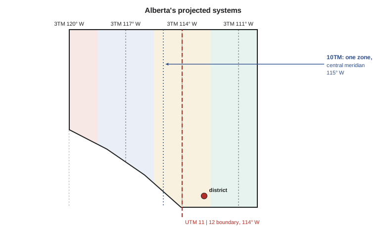
Alberta uses two transverse Mercator systems of its own, both on NAD83 (now NAD83(CSRS)). The 3TM system divides the province into four bands 3° of longitude wide, with central meridians at 111°, 114°, 117° and 120° W, a central scale factor of 0.9999 and a false easting and northing of zero. Its scale stays within about −100 to +50 ppm across each band in southern Alberta, a quarter of UTM's range, and it is the system in which Alberta's survey control markers are published and many municipal and engineering projects are run. Because the false easting is zero, points west of a central meridian have negative eastings, a detail that catches out software expecting positive coordinates. The district lies in the 114° W band of 3TM, close enough to the central meridian that its scale factor is within about 15 ppm of one.
The 10TM system covers the whole province in a single transverse Mercator zone with central meridian 115° W and central scale factor 0.9992. It exists in two versions with the same projection: 10TM Resource, with a false easting of zero, and 10TM Forest, with a false easting of 500,000 m, which keeps eastings positive. One zone for the whole province makes 10TM convenient for provincial resource and forestry databases, and its scale range of about −800 to +850 ppm across Alberta's width is acceptable for those uses. Data exchanged with provincial ministries are often in 10TM, and the 'Resource' and 'Forest' versions are easy to confuse because their northings are identical.
| System | Projection | Central meridian(s) | k₀ | False easting | Used for |
|---|---|---|---|---|---|
| UTM zone 11 or 12 | TM, 6° zones | 117° W, 111° W | 0.9996 | 500,000 m | Federal mapping, GIS, imagery |
| Alberta 3TM | TM, 3° bands | 111°, 114°, 117°, 120° W | 0.9999 | 0 m | Survey control, municipal and engineering work |
| Alberta 10TM Resource | TM, one zone | 115° W | 0.9992 | 0 m | Provincial resource data |
| Alberta 10TM Forest | TM, one zone | 115° W | 0.9992 | 500,000 m | Provincial forestry data |
| Ontario and Quebec MTM | TM, 3° zones | Every 3°, e.g. 76.5° W for zone 9 | 0.9999 | 304,800 m | Survey and municipal work |
| New Brunswick | Double stereographic | Centre 46.5° N, 66.5° W | 0.999912 | 2,500,000 m | Provincial survey and mapping |
import math
A_GRS80 = 6378137.0
F_GRS80 = 1 / 298.257222101

def tm_setup(a=A_GRS80, f=F_GRS80):
    n = f / (2 - f)
    A = a / (1 + n) * (1 + n**2 / 4 + n**4 / 64 + n**6 / 256)
    al = [n/2 - 2*n**2/3 + 5*n**3/16 + 41*n**4/180 - 127*n**5/288 + 7891*n**6/37800,
          13*n**2/48 - 3*n**3/5 + 557*n**4/1440 + 281*n**5/630 - 1983433*n**6/1935360,
          61*n**3/240 - 103*n**4/140 + 15061*n**5/26880 + 167603*n**6/181440,
          49561*n**4/161280 - 179*n**5/168 + 6601661*n**6/7257600,
          34729*n**5/80640 - 3418889*n**6/1995840,
          212378941*n**6/319334400]
    be = [n/2 - 2*n**2/3 + 37*n**3/96 - n**4/360 - 81*n**5/512 + 96199*n**6/604800,
          n**2/48 + n**3/15 - 437*n**4/1440 + 46*n**5/105 - 1118711*n**6/3870720,
          17*n**3/480 - 37*n**4/840 - 209*n**5/4480 + 5569*n**6/90720,
          4397*n**4/161280 - 11*n**5/504 - 830251*n**6/7257600,
          4583*n**5/161280 - 108847*n**6/3991680,
          20648693*n**6/638668800]
    e = math.sqrt(f * (2 - f))
    return n, A, al, be, e

def tm_forward(lat, lon, lon0, k0, fe=0.0, fn=0.0, a=A_GRS80, f=F_GRS80):
    """Geodetic latitude and longitude (degrees) to TM easting, northing,
    point scale factor k and grid convergence gamma (degrees)."""
    n, A, al, be, e = tm_setup(a, f)
    phi = math.radians(lat); dl = math.radians(lon - lon0)
    t = math.sinh(math.atanh(math.sin(phi)) - e * math.atanh(e * math.sin(phi)))
    xi1 = math.atan2(t, math.cos(dl)); eta1 = math.atanh(math.sin(dl) / math.sqrt(1 + t * t))
    xi, eta = xi1, eta1; p, q = 1.0, 0.0
    for j in range(1, 7):
        xi += al[j-1] * math.sin(2*j*xi1) * math.cosh(2*j*eta1)
        eta += al[j-1] * math.cos(2*j*xi1) * math.sinh(2*j*eta1)
        p += 2*j*al[j-1] * math.cos(2*j*xi1) * math.cosh(2*j*eta1)
        q += 2*j*al[j-1] * math.sin(2*j*xi1) * math.sinh(2*j*eta1)
    E = fe + k0 * A * eta; N = fn + k0 * A * xi
    k = k0 * A / a * math.sqrt(1 + ((1 - n) / (1 + n) * math.tan(phi))**2) * math.sqrt(p*p + q*q) / math.sqrt(t*t + math.cos(dl)**2)
    g1 = math.atan2(t * math.tan(dl), math.sqrt(1 + t*t))
    g2 = math.atan2(q, p)
    return E, N, k, math.degrees(g1 + g2)

def tm_inverse(E, N, lon0, k0, fe=0.0, fn=0.0, a=A_GRS80, f=F_GRS80):
    """TM easting and northing back to latitude and longitude (degrees)."""
    n, A, al, be, e = tm_setup(a, f)
    xi = (N - fn) / (k0 * A); eta = (E - fe) / (k0 * A)
    xi1, eta1 = xi, eta
    for j in range(1, 7):
        xi1 -= be[j-1] * math.sin(2*j*xi) * math.cosh(2*j*eta)
        eta1 -= be[j-1] * math.cos(2*j*xi) * math.sinh(2*j*eta)
    chi = math.asin(math.sin(xi1) / math.cosh(eta1))
    lam = math.atan2(math.sinh(eta1), math.cos(xi1))
    t0 = math.tan(chi); t = t0
    for _ in range(10):
        sig = math.sinh(e * math.atanh(e * t / math.sqrt(1 + t*t)))
        tp = t * math.sqrt(1 + sig*sig) - sig * math.sqrt(1 + t*t)
        dt = (t0 - tp) / math.sqrt(1 + tp*tp) * (1 + (1 - e*e) * t*t) / ((1 - e*e) * math.sqrt(1 + t*t))
        t += dt
        if abs(dt) < 1e-14: break
    return math.degrees(math.atan(t)), lon0 + math.degrees(lam)

def dms(x):
    s = '-' if x < 0 else ''; x = abs(x); d = int(x); m = int((x - d) * 60); sec = ((x - d) * 60 - m) * 60
    if sec >= 59.99995: sec -= 60; m += 1
    if m == 60: m = 0; d += 1
    return f"{s}{d}°{m:02d}'{sec:07.4f}\""

lat, lon = 49.69673058, -112.82708789          # pillar CR1, Lethbridge
systems = [
    ("UTM zone 12",            -111.0, 0.9996, 500000.0),
    ("Alberta 3TM, 114 W",     -114.0, 0.9999, 0.0),
    ("Alberta 10TM Resource",  -115.0, 0.9992, 0.0),
    ("Alberta 10TM Forest",    -115.0, 0.9992, 500000.0),
]
print(f"{'system':24s}{'easting':>14s}{'northing':>15s}{'k':>12s}{'convergence':>13s}")
for name, lon0, k0, fe in systems:
    E, N, k, g = tm_forward(lat, lon, lon0, k0, fe, 0.0)
    print(f"{name:24s}{E:14.3f}{N:15.3f}{k:12.7f}{g:+12.4f}")

# The same 1,000.000 m on the ground near CR1 (ignoring height for now) in each system
print("\nGrid length of a 1,000.000 m ellipsoid distance near CR1:")
for name, lon0, k0, fe in systems:
    k = tm_forward(lat, lon, lon0, k0, fe, 0.0)[2]
    print(f"  {name:24s}{1000*k:10.3f} m  ({(k-1)*1e6:+7.1f} ppm)")

# An Ontario example: Parliament Hill, Ottawa, in MTM zone 9 (central meridian 76.5 W)
plat, plon = 45.4236, -75.7009
E, N, k, g = tm_forward(plat, plon, -76.5, 0.9999, 304800.0, 0.0)
zE, zN, zk, zg = tm_forward(plat, plon, -75.0, 0.9996, 500000.0, 0.0)
print(f"\nOttawa in MTM zone 9: E = {E:.1f}  N = {N:.1f}  k = {k:.7f}")
print(f"Ottawa in UTM zone 18: E = {zE:.1f} N = {zN:.1f} k = {zk:.7f}")system easting northing k convergence UTM zone 12 368239.741 5506515.119 0.9998132 -1.3936 Alberta 3TM, 114 W 84611.192 5507225.359 0.9999879 +0.8946 Alberta 10TM Resource 156634.846 5504975.491 0.9995015 +1.6575 Alberta 10TM Forest 656634.846 5504975.491 0.9995015 +1.6575 Grid length of a 1,000.000 m ellipsoid distance near CR1: UTM zone 12 999.813 m ( -186.8 ppm) Alberta 3TM, 114 W 999.988 m ( -12.1 ppm) Alberta 10TM Resource 999.501 m ( -498.5 ppm) Alberta 10TM Forest 999.501 m ( -498.5 ppm) Ottawa in MTM zone 9: E = 367334.2 N = 5031829.0 k = 0.9999481 Ottawa in UTM zone 18: E = 445166.9 N = 5030247.7 k = 0.9996370
The code shows the differences clearly. CR1 has eastings of 368,240 m in UTM, 84,611 m in 3TM, 156,635 m in 10TM Resource and 656,635 m in 10TM Forest, and northings that differ by up to 2.2 km because each system has a different central meridian and scale. The 3TM scale factor at CR1 is 0.9999879, so a 1,000 m line is only 12 mm short on the 3TM grid, compared with 187 mm on UTM and 499 mm on 10TM. The convergence is −1.39° on UTM, +0.89° on 3TM and +1.66° on 10TM, because CR1 is west of UTM's central meridian and east of the other two. A bearing on a drawing is meaningless without knowing which of these grids it refers to.
Ontario and Quebec: MTM
Ontario and Quebec, and with variations the Atlantic provinces, use the modified transverse Mercator (MTM) system for survey and municipal work. MTM zones are 3° wide, with central meridians every 3° of longitude, a central scale factor of 0.9999 and a false easting of 304,800 m, a value chosen in the days of imperial units as 1,000,000 feet. Zones are numbered from the east: zone 9 has its central meridian at 76.5° W and covers Ottawa, and zone 10, at 79.5° W, covers Toronto. Large parts of Ontario's municipal mapping and parcel fabric, and much of Quebec's cadastre, are in MTM. As the code shows, Parliament Hill in Ottawa has a scale factor of 0.99995 in MTM zone 9 against 0.99964 in UTM zone 18, a difference of 300 ppm that matters on every construction site in the city.
Other provinces and territories
British Columbia uses UTM for most survey work and an Albers equal-area conic for provincial mapping and statistics, as noted in lesson 4. Saskatchewan and Manitoba use UTM for most purposes. New Brunswick and Prince Edward Island use oblique stereographic projections, described in lesson 5, that cover each province with a single conformal grid. Nova Scotia uses its own 3° transverse Mercator zones, and Newfoundland and Labrador uses MTM zones in Newfoundland and UTM in Labrador. The territories use UTM and, for northern mapping, polar stereographic and Lambert conformal conic projections. Every one of these systems is now normally realized on NAD83(CSRS), and a coordinate in any of them is meaningless without the datum, its version and, for precise work, its epoch, which lesson 10 discusses.
Survey systems that are not projections
Two survey frameworks in Canada are easily mistaken for coordinate systems. The Dominion Land Survey, which in Alberta is called the Alberta Township System (ATS), divides the land into townships, ranges, sections and legal subdivisions referenced to meridians such as the Fourth Meridian at 110° W. It is a system of legal boundaries, not a projection: a section's corners were monumented on the ground, and a legal description such as NE-22-9-22-W4 identifies a parcel, not a coordinate. Published ATS grids, such as those distributed by AltaLIS and used by the district's GIS in GEOM-330, are approximations of where those corners lie, computed in a projected system. The second framework is the network of survey control monuments, which in Alberta are the Alberta Survey Control Markers. Their coordinates are published in 3TM and as latitude and longitude on NAD83(CSRS); they tie surveys to the projected systems, but the monuments themselves are physical marks, and their published coordinates have stated accuracies.
Choosing a system for the district
Leah's recommendation followed the uses. The GIS master data remained in UTM zone 12 on NAD83(CSRS), shared with the province's imagery and the federal base data. Survey control and legal surveys tied to the Alberta Survey Control Markers would be reported in 3TM, the provincial survey system, with grid distances converted to ground distances by the combined factor of lesson 8. Engineering design for the canal rehabilitation, where contractors stake from coordinates with total stations and expect grid distances to agree with measured distances, would use a low-distortion projection designed for the district, also described in lesson 8, with a documented transformation from 3TM. Provincial resource data arriving in 10TM would be transformed on load. Each choice was written into the district's data standard with its EPSG code where one exists.
Worked problem
Recognizing a system from its coordinates
A consultant's file gives a point near the district as E 84,600, N 5,507,200 with no description. Another gives E 156,600, N 5,505,000, and a third E 368,200, N 5,506,500. Which systems are they likely to be?
Show solution
- An easting near 85 km with a northing near 5,507 km fits 3TM 114° W: a point 1.2° east of the central meridian with zero false easting.
- An easting near 157 km fits 10TM Resource: a point 2.2° east of 115° W with zero false easting; 10TM Forest would be near 657 km.
- An easting near 368 km fits UTM zone 12: 132 km west of the 500 km false easting.
Answer: Recognizing the pattern is a useful check, but it is never a substitute for a stated CRS. A file without a stated CRS should be returned, or its CRS confirmed by checking a known point.
Worked problem
Grid length in MTM
A 450.000 m line on the ellipsoid lies where the MTM zone 9 scale factor is 0.9999481. What is its grid length, and how different would it be in UTM zone 18 where k = 0.9996370?
Show solution
- \[L_{MTM} = 450.000 \times 0.9999481 = 449.977 \text{ m}\]
- \[L_{UTM} = 450.000 \times 0.9996370 = 449.837 \text{ m}\]
Answer: The MTM grid length differs from the ellipsoid length by 23 mm, the UTM grid length by 163 mm. Neither yet includes the height factor.
Common mistakes
MistakeAssuming all Alberta data are in UTM.
InsteadCheck for 3TM, 10TM Resource and 10TM Forest, and for UTM zones 11 and 12.
MistakeConfusing 10TM Resource and 10TM Forest.
InsteadTheir northings are identical; their eastings differ by exactly 500,000 m.
MistakeRejecting negative 3TM eastings as errors.
InsteadWith zero false easting, points west of a central meridian have negative eastings.
MistakeTreating an ATS grid as surveyed boundaries.
InsteadATS grids approximate legal corners; boundaries are defined by the survey on the ground.
MistakeOmitting the datum version and epoch with provincial coordinates.
InsteadState NAD83(CSRS), its version and the epoch for precise work.
Summary and key terms
- Federal mapping in Canada uses UTM; provinces use their own systems for survey and municipal work.
- Alberta uses 3TM (3° bands, k0 0.9999, false easting 0) and 10TM (one zone at 115° W, k0 0.9992), plus UTM.
- Ontario and Quebec use MTM: 3° zones, k0 0.9999, false easting 304,800 m.
- New Brunswick and Prince Edward Island use oblique stereographic grids; British Columbia uses Albers for provincial mapping.
- The ATS and survey control networks are legal and physical frameworks, not projections.
- Choose the system by use: UTM for GIS, the provincial system for control and legal ties, a low-distortion projection for construction.
- 3TM
- Alberta's 3°-wide transverse Mercator bands with k0 = 0.9999 and zero false easting.
- 10TM
- Alberta's single transverse Mercator zone at 115° W with k0 = 0.9992, in Resource and Forest versions.
- MTM
- Modified transverse Mercator, 3° zones used in Ontario, Quebec and the Atlantic provinces.
- Alberta Township System
- Alberta's form of the Dominion Land Survey of townships, ranges, sections and legal subdivisions.
- Survey control marker
- A monument with published coordinates used to tie surveys to the datum.
- EPSG code
- An identifier in the EPSG registry for a CRS or transformation.
Practice problems
Work each problem on paper first, then reveal the answer to check.
What are the central meridians of Alberta's 3TM bands?
Show answer
111°, 114°, 117° and 120° W.
What false easting does MTM use, and where does the value come from?
Show answer
304,800 m, which is 1,000,000 feet.
Why is 10TM used for provincial resource databases rather than 3TM?
Show answer
One zone covers the whole province; its larger distortion is acceptable for resource data.
A point has a 3TM easting of −45,000 m in the 114° W band. Is that an error?
Show answer
No; the point is about 45 km west of 114° W.
Which system would you use for the district's survey control report, and why?
Show answer
3TM, the provincial survey system in which control markers are published.
Lesson quiz · 5 questions
Score 60% or more to complete this lesson.
Create a free account to save your progress, take quizzes and earn a certificate.