
DCE-410 · Lesson 4 of 12 · 25 min
Land acquisition and due diligence
Once the search has produced a short list, the developer must secure land without committing to a site that later proves unbuildable. Data center parcels are large, often assembled from several owners, and their value depends on facts that take months to establish: whether the land can be zoned, whether power and water can reach it, what lies under its surface, and what rights others hold over it. This lesson covers the agreements used to secure land, title and survey, environmental and physical investigations, utility and access confirmation, yield studies that estimate how much capacity a parcel can hold, and the planning of the due diligence period itself.
Securing the land
Developers rarely buy land outright at the start. The usual tools are:
- Option agreements: the developer pays the owner for the exclusive right to buy the land at an agreed price within a set period (often one to three years, sometimes with paid extensions). If the site fails, the developer walks away, losing only the option payments.
- Purchase and sale agreements with contingencies: the purchase is binding only if contingencies are satisfied or waived by set dates, typically a feasibility or due diligence period (60 to 180 days), an entitlement contingency for rezoning, and sometimes a power contingency tied to a utility commitment.
- Ground leases: long leases (often 50 to 99 years) where owners will not sell, or where public bodies, utilities or Indigenous communities prefer to retain ownership.
- Assemblies: where a site requires several parcels, each is secured under its own agreement, ideally with conditions that let the developer proceed only if the whole assembly closes.
Prices for data center land have risen sharply in active markets, and owners near transmission lines or substations increasingly know their land's value. Agreements often include price escalators for extensions, payments released in stages as conditions are satisfied, and provisions on who pays for rezoning applications and studies. The agreement also needs to give the developer access to the land for surveys, drilling and environmental sampling during the due diligence period, with obligations to restore it.
Some US sites involve additional parties: state and federal land requires a lease or sale process through the managing agency, which may itself trigger environmental review (Lesson 5); tribal trust land requires agreements with the tribe and approval by the Bureau of Indian Affairs; and farmland in some states is enrolled in preservation or agricultural use-value programs whose withdrawal triggers rollback taxes or penalties.
Title and survey
A title search confirms who owns the land and what rights others hold over it. The issues that matter most for data centers are:
- Easements: rights of way for transmission lines, pipelines, roads and drainage. A high-voltage line crossing the middle of a parcel can remove a strip 30 to 60 m wide from use and restrict building near it, while a gas pipeline easement limits grading, crossings and heavy equipment.
- Restrictive covenants: private restrictions on use, height or building materials, sometimes registered decades ago by a developer of a business park.
- Subsurface and mineral rights: in many states, oil, gas and mineral rights may be severed from the surface and owned by others, who may have rights to access and drill.
- Leases and occupancies: farm leases, billboard leases and telecommunications towers that must be terminated or relocated.
An ALTA/NSPS land title survey fixes boundaries and shows easements, encroachments, improvements, flood zone designations and access, to a standard accepted by title insurers and lenders. A title commitment from the title insurer lists the exceptions to coverage; working through each exception, and obtaining endorsements, is a standard part of due diligence.
Environmental site assessment
Contamination can make a site expensive or impossible to use, and in many jurisdictions an owner can be liable for cleaning up contamination it did not cause. Environmental due diligence proceeds in phases:
- A Phase I Environmental Site Assessment, following ASTM E1527-21 and the EPA's All Appropriate Inquiries rule, reviews historical records, aerial photographs, regulatory databases and a site visit to identify recognized environmental conditions. Completing it before purchase is necessary to qualify for landowner liability protections under CERCLA, such as the bona fide prospective purchaser defense.
- A Phase Two (or Phase II) assessment samples soil, groundwater and sometimes soil vapor where the first phase found concerns, such as former fuel tanks, landfills, industrial uses or pesticide storage.
- If contamination is confirmed, remediation under a state voluntary cleanup or brownfields program can provide liability relief, and some states offer incentives for redeveloping brownfields, including former power plant and industrial sites attractive for their existing transmission connections.
Former power plants, factories and mines can make excellent data center sites because they bring transmission interconnections, water rights and industrial zoning, but they need especially careful environmental assessment of ash ponds, fuel storage and buried structures.
Physical investigations
- Geotechnical investigation: boreholes and test pits establish soil and rock conditions, groundwater levels, bearing capacity and seismic site class, which govern foundation design and earthworks (DCE-430). Soft clays, karst (limestone prone to sinkholes), high groundwater and expansive soils add cost and risk.
- Topographic survey and grading study: data center buildings need large flat pads; a sloping site may require extensive cut and fill and retaining walls.
- Floodplain and drainage: confirm flood mapping, local drainage patterns and the outlet for stormwater (Lesson 7).
- Wetlands and waters: a wetland delineation and, where needed, a jurisdictional determination from the US Army Corps of Engineers establish whether Clean Water Act permits are required (Lesson 5); species surveys are timed for the right seasons.
- Cultural resources: a Phase I archaeological survey may be required by state or local rules, and by Section 106 of the National Historic Preservation Act if there is a federal permit or funding.
Seasonal timing matters: some species surveys can only be done in spring or early summer, and archaeological field surveys require plowed fields or suitable ground conditions, so a due diligence plan that starts in late autumn can lose six months waiting for the field season.
Utilities and access
Physical suitability means little without services:
- Power: a formal request to the utility or system operator, leading to a feasibility or system impact study that states available capacity, required upgrades, costs and dates (DCE-420). For large loads this can take months and require deposits.
- Water and wastewater: written confirmation from the municipality or utility of available capacity, or a hydrogeological study for wells (Lesson 7).
- Fiber: confirmation from carriers of available routes, diverse entrances and construction costs.
- Road access: approvals for new entrances and the capacity of roads for construction traffic and heavy deliveries such as transformers and generators (Lesson 6).
- Gas: where on-site generation is planned, capacity on nearby pipelines.
Yield studies
A yield study estimates how much data center capacity a parcel can support once constraints are removed. Starting from the gross area, it subtracts wetlands and buffers, floodplains, easements, setbacks, road widenings, stormwater facilities and the utility substation, then applies a building coverage and a power density to the net developable area.
# Yield study for a 60 ha parcel: how much IT capacity can it support?
gross_ha = 60.0
constraints_ha = {"wetland and buffer": 4.5, "floodplain": 3.0, "transmission easement": 2.2, "road widening and setbacks": 3.8,
                  "stormwater ponds": 4.0, "substation": 2.0}
net_ha = gross_ha - sum(constraints_ha.values())
print(f"gross {gross_ha:.1f} ha; constraints {sum(constraints_ha.values()):.1f} ha; net developable {net_ha:.1f} ha")

# Of the net area, buildings cover 40%; the rest is generators, cooling yards, roads and parking.
coverage = 0.40
building_m2 = net_ha * 10000 * coverage
for label, w_per_m2 in (("air-cooled, 1.5 kW/m2 of building", 1500), ("liquid-cooled AI, 3.0 kW/m2 of building", 3000)):
    it_mw = building_m2 * w_per_m2 / 1e6
    print(f"{label}: about {it_mw:.0f} MW of IT capacity on {building_m2 / 1e4:.1f} ha of building footprint (single storey)")

pue = 1.25
print(f"utility demand for the AI case at PUE {pue}: about {building_m2 * 3000 / 1e6 * pue:.0f} MW")gross 60.0 ha; constraints 19.5 ha; net developable 40.5 ha air-cooled, 1.5 kW/m2 of building: about 243 MW of IT capacity on 16.2 ha of building footprint (single story) liquid-cooled AI, 3.0 kW/m2 of building: about 486 MW of IT capacity on 16.2 ha of building footprint (single story) utility demand for the AI case at PUE 1.25: about 608 MW
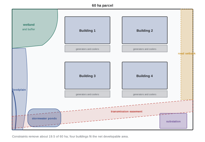
Constraints remove about a third of this parcel. The capacity estimate depends heavily on the cooling technology: liquid-cooled AI halls pack roughly twice the power into the same footprint, so the binding constraint shifts from land to power, here more than 600 MW of utility demand, far beyond what most single connections can supply. Multi-story buildings, increasingly common where land is scarce, raise capacity further. A yield study also checks that the layout can meet noise limits at property lines (Lesson 6) and that generator and fuel areas satisfy fire separation requirements.
Planning the due diligence period
Due diligence is a project in itself, with a budget, schedule and risk register. Its order matters: investigations that can reveal fatal flaws cheaply come first.
Worked problem
Sequencing due diligence
A developer has a 120-day due diligence period. Candidate investigations, with costs and durations, are: title review ($15,000, 3 weeks), Phase I ESA ($8,000, 4 weeks), utility feasibility study ($150,000 deposit, 12 to 20 weeks), geotechnical investigation ($120,000, 8 weeks), wetland and species surveys ($60,000, seasonal), and a full traffic study ($50,000, 8 weeks). How should they be sequenced?
Show solution
- Day 1: submit the utility study request immediately, since it is the longest and most decisive; start title review and the Phase I.
- Weeks 3 to 4: review title and Phase I results; if a fatal flaw appears (an unmovable easement, serious contamination), stop before spending on the rest.
- Weeks 4 to 12: geotechnical investigation and the natural heritage surveys, if in season; a scoping-level traffic memo rather than the full study.
- Weeks 12 to 17: review the utility study; negotiate an extension if it is late, using the option agreement's extension rights.
Answer: Start the longest and most decisive item first and the cheap fatal-flaw checks in parallel, defer costly detailed studies until the cheap ones pass, and build extension rights into the land agreement because utility studies often run late.
Typical red flags that end or reprice a deal include: no credible power date; a major easement or pipeline that splits the site; significant contamination; wetlands or species habitat covering much of the parcel; a floodplain designation; unresolvable access; an archaeological site of high significance; strong organized local opposition with a council that has signaled it will not rezone; and an owner unable to give clean title.
Common mistakes
MistakeBuying land unconditionally before confirming power and zoning.
InsteadUse options or conditional agreements with due diligence, approvals and power conditions.
MistakeOverlooking easements and severed mineral rights.
InsteadReview title and survey early; map every easement and its restrictions.
MistakeSkipping the environmental assessment on farmland.
InsteadFormer tanks, dumps and pesticide storage are common; a first-phase assessment is cheap protection.
MistakeStarting natural heritage surveys out of season.
InsteadPlan around field seasons; missed windows cost months.
MistakeEstimating capacity from gross acreage.
InsteadRun a yield study that subtracts constraints and checks power, noise and fire separation.
Summary and key terms
- Options, conditional purchase agreements and ground leases secure land while limiting commitment.
- Title and survey reveal easements, covenants, mineral rights and leases that constrain development.
- Phased environmental site assessments identify contamination and protect against liability.
- Geotechnical, grading, flood, natural heritage and archaeological investigations establish buildability, with seasonal timing.
- Power, water, fiber, road and gas must be confirmed in writing.
- Yield studies convert gross area to developable capacity; due diligence is sequenced to find fatal flaws cheaply.
- Option agreement
- A paid right to buy land at a set price within a set period.
- Condition precedent
- A condition that must be met before an agreement becomes binding.
- Ground lease
- A long-term lease of land on which the tenant builds.
- Easement
- A right held by another party to use part of the land for a purpose.
- Restrictive covenant
- A registered private restriction on the use of land.
- Phase One ESA
- A records-based environmental assessment identifying potential contamination.
- Geotechnical investigation
- Subsurface exploration of soil, rock and groundwater for design.
- Yield study
- An estimate of developable area and capacity after constraints.
- Net developable area
- Gross area minus constrained land.
- Red flag
- A finding that may end or reprice a land transaction.
Practice problems
Work each problem on paper first, then reveal the answer to check.
Why are option agreements favored early in a project?
Show answer
They secure the land while limiting loss if the site fails.
A transmission easement 45 m wide crosses 600 m of a site. Area lost?
Show answer
2.7 ha.
What does a first-phase environmental assessment involve?
Show answer
Records review, historical photos, database searches and a site visit, without sampling.
When is a second-phase assessment needed?
Show answer
When the first phase identifies potential contamination.
Why are former power plant sites attractive?
Show answer
Existing transmission, water and industrial zoning.
Name two geotechnical conditions that add cost.
Show answer
Karst, soft clay, high groundwater or expansive soils.
Net area of an 80 ha parcel with 26 ha of constraints?
Show answer
54 ha.
With 40% coverage and 2 kW/m², capacity of 54 ha net?
Show answer
\(54 \times 10{,}000 \times 0.4 \times 2 = 432\) MW.
Which due diligence item should usually start on day one?
Show answer
The utility power study request.
Name three red flags.
Show answer
No power date, contamination, splitting easement, wetlands, floodplain, opposition, unclear title.
Lesson quiz · 5 questions
Score 60% or more to complete this lesson.
Create a free account to save your progress, take quizzes and earn a certificate.