
ARCH-440 · Lesson 4 of 12 · 21 min
Colonialism and space
For the fourth week, Professor Morningstar brings two maps and lays them side by side on the table. The first is a survey plan of the city from the 1870s, ruled into perfect squares that run straight over the rivers and the creek beds. The second is a hand-drawn map made recently by Dakota elders and community historians, showing trails, gathering places, river crossings, burial grounds and the names of places in their languages. 'Both of these are maps of the same land,' she says. 'One was made to divide it and sell it. The other was made to remember it. Architects and planners have mostly worked from the first kind of map. This week we look at what that has meant.' Joon-ho asks which map is more accurate. The professor smiles. 'Accurate about what?'
Colonialism is the process by which one people takes control of another people's land, government, economy and culture. Settler colonialism, the form that shaped Canada and the United States, is distinct because the colonizers came to stay: its goal was not only to rule Indigenous peoples but to replace them on the land. Space was central to this process. Land was surveyed, divided, sold and built on; Indigenous peoples were confined to small reserved areas; and towns, roads and buildings made the new order permanent. This lesson examines how colonialism worked through space and architecture, and how communities are reclaiming land and place today.
Doctrines of discovery and empty land
European colonial powers justified taking land in the Americas with legal ideas developed in the fifteenth and sixteenth centuries. The Doctrine of Discovery, grounded in papal bulls of the 1450s and 1493, held that Christian nations could claim lands not ruled by Christians. The related idea of terra nullius, land belonging to no one, treated land that was not farmed or built on in a European way as empty, ignoring the nations who lived on, managed and governed it. In 1823 the United States Supreme Court, in Johnson v. M'Intosh, adopted the Doctrine of Discovery into American law, and Canadian courts long relied on similar ideas. In 2023 the Vatican formally repudiated the doctrine, and both countries have begun to reject it in law and policy.
These ideas had an architectural consequence: they made Indigenous building invisible. A village of wiigiwaams, a seasonal camp or a managed landscape of berry patches and burned prairie did not count as occupation in European eyes, while a fenced field and a log house did. The history of architecture you learned in school, which mostly begins in North America with the colonial church and the settler farmhouse, repeats this blindness.
Treaties and the land
In what is now the United States, the federal government made hundreds of treaties with tribal nations between 1778 and 1871, exchanging land for reserved lands, payments, goods and services. In Minnesota, the Dakota signed the Treaties of Traverse des Sioux and Mendota in 1851, ceding most of their land in the southern part of the state, about 24 million acres, in exchange for a reservation along the Minnesota River and promised payments. When payments were delayed and traders refused credit during a hungry summer, the US–Dakota War broke out in 1862. After it, thirty-eight Dakota men were hanged at Mankato on 26 December 1862, the largest mass execution in United States history, and the Dakota were expelled from Minnesota. Minneapolis stands on Dakota homelands, which the Dakota call Mni Sota Makoce.
The grid and the survey
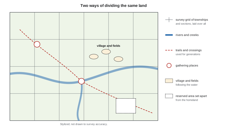
The survey grid was the most powerful spatial tool of settler colonialism. In the United States, the Land Ordinance of 1785 created the Public Land Survey System, which divided the western territories into townships six miles square, each split into thirty-six sections of one square mile. In Canada, the Dominion Lands Survey, begun in 1871, used a similar system of townships and sections across the Prairies. The grid turned land into a commodity that could be described on paper, sold from afar and registered in a title office. It ignored rivers, hills, trails and existing communities, and it remains visible today in the straight roads and square fields of the Prairies and the Plains and in the street grids of their cities.
The grid collided with older patterns. Along the Mississippi, the Detroit River and the rivers of Louisiana, French settlers had laid out long lots, narrow strips running back from the water that gave each household river access, farmland and woodland, a pattern often shaped by earlier Indigenous villages and fields. When American surveyors arrived, they generally recognized the existing long lots but laid the grid around them, and the contrast still shows in maps of places such as Detroit and St. Louis. On Dakota and Ojibwe land in Minnesota, the grid was laid over villages, rice lakes, sugar bushes and trails that had no place on the survey plan. Across the continent, the grid similarly overrode the village plans and field patterns of Indigenous nations.
Reserves, reservations and confinement
As settlers took land, Indigenous nations were confined to small reserved areas. In the United States, the Indian Removal Act of 1830 forced nations of the Southeast west of the Mississippi, on journeys such as the Cherokee Trail of Tears. Later, reservations were created across the West, often on land no settler wanted. The Dawes Act of 1887 divided many reservations into individual allotments and sold the remainder to settlers; tribal land holdings fell from about 138 million acres in 1887 to about 48 million by 1934. Life on reserved land was shaped by government plans: houses built to standard designs, laid out on grids or along roads, with a church, an agent's house and a school set in positions of control.
The most damaging institutions were the schools. For more than a century, the federal government and churches ran boarding schools, beginning with the Carlisle Indian Industrial School in Pennsylvania in 1879, whose founder's slogan was to kill the Indian and save the man. A federal investigation begun in 2021 identified more than 400 such schools. In 2024 the president issued a formal apology for the system. The school buildings were designed to impress and control: large, symmetrical brick buildings in classical or Gothic styles, with dormitories, chapels and supervision built into the plan. Many survivors and communities now decide what should happen to these buildings: some have been demolished, some preserved as places of memory, and some reclaimed for new uses by the nations themselves.
Erasure in the city
Colonialism also shaped cities. Indigenous people were largely excluded from urban life for much of the twentieth century, and the communities that formed at city edges were often removed. In Saint Paul, the construction of Interstate 94 in the 1950s and 1960s destroyed much of Rondo, the heart of the city's Black community, as you saw in ARCH-340; in Minneapolis, urban renewal and highway building displaced many Native families who had come to the city under the relocation program. The names of places changed too: Indigenous names were replaced with the names of settlers, kings and generals, and Indigenous presence was reduced to a few statues and street names, often stereotyped.
Infrastructure carried colonial relationships as well. A striking example is the Missouri River dams built after the Second World War, such as the Garrison Dam in North Dakota, which flooded the best bottomland of the Mandan, Hidatsa and Arikara Nation, including towns, farms and burial grounds, and forced most of the nation's people to move to the uplands. For architects and engineers, such cases are reminders that infrastructure decisions about water, roads and energy have often been made at the expense of Indigenous communities.
| Spatial tool | How it worked | Legacy today |
|---|---|---|
| Survey grid | Turned land into saleable parcels and ignored existing patterns | Square roads, fields and street grids |
| Reserved land | Confined nations to small areas, often poor land | Distance from services, crowding, under-investment |
| Institutional buildings | Schools, churches and agencies built to control | Sites of trauma, now being reclaimed or memorialized |
| Urban clearance | Removed Indigenous and racialized communities | Lost neighborhoods and displaced families |
| Infrastructure | Dams, aqueducts and roads built through Indigenous land | Flooded homelands and cut-off communities |
Reclaiming space
Indigenous nations are reclaiming land and place through many routes. The movement often called Land Back seeks the return of land and decision-making to Indigenous nations. Treaty land entitlement and land claims settlements have returned land to some nations, and some of that land is in cities. In Minneapolis, the Native community has built its own institutions along Franklin Avenue, and tribal nations and Native organizations have acquired land for housing, gardens and cultural sites, while campaigns have restored Dakota names, such as Bde Maka Ska for the lake long named after a pro-slavery politician. Co-management agreements give nations a role in parks and protected areas, and Indigenous place names are being restored on maps and signs.
Architecture plays a part. New buildings designed by and with Indigenous communities, such as those you met in Lesson 3, change the face of cities. Land acknowledgments, now common at public events, can be a beginning, but many Indigenous people point out that an acknowledgment without action is empty. For architects, more meaningful steps include learning the history of a site before designing on it, involving the nations whose land it is, supporting Indigenous designers and recognizing Indigenous presence in the design itself, in names, landscapes, materials and spaces, when the nations wish it.
Worked problem
Reading a site's colonial history
Wren's studio site is a vacant lot by the river. The survey shows a rectangular parcel on the city grid. How should she investigate its history before designing?
Show solution
- Find the nations whose traditional territory includes the site and the treaties or agreements that apply.
- Look at historical maps and photographs to see what was there before the grid: trails, river crossings, villages, river lots or gathering places.
- Check for any record of earlier communities that were removed, and of burial or archaeological sites, which may require consultation.
- Contact the relevant nations or Indigenous organizations to ask whether the site has meaning for them and whether they wish to be involved.
- Record what she learns and let it shape the design brief, from orientation and landscape to program and naming.
Answer: Wren discovers that the lot lies beside an old river crossing used for centuries. With the community's guidance, her design keeps a view and a path to the crossing open, instead of building across it.
Exercise 4: two maps
This exercise takes about four hours.
- Choose a district of your city and find the earliest survey or subdivision plan you can.
- Using sources from Indigenous nations, historical societies and archives, map what existed before and what was lost or changed.
- Overlay the two maps and mark at least three places where the grid overrode an earlier pattern.
- Deliverable: the overlay map and a 600-word essay on what the comparison reveals and what an architect working in the district should do with this knowledge.
Self-critique checklist
- Have I used Indigenous sources as well as government records?
- Have I distinguished the written terms of treaties from the understanding of the nations that signed them?
- Have I avoided presenting colonialism as finished history?
- Have I proposed actions, not only acknowledgments?
Colonial space in everyday buildings
Colonial patterns also survive in ordinary places that architects design every day. Public buildings in many cities still present their grandest face to the street grid and their backs to the river, reversing the older relationship in which rivers were the main routes and gathering places. Parks and monuments often commemorate settlers, soldiers and officials while saying nothing of the nations whose land they occupy. Street names, school names and even the names of rooms in public buildings carry the same history. Reviewing these choices is part of an architect's work on any public project: which way does the building face, whose history does it tell, and whose is missing?
Planning rules can carry colonial assumptions too. Zoning that permits only single-family houses on large lots, minimum lot sizes, limits on the number of unrelated people who may share a house and bans on outdoor fires or on keeping and preparing game can make it difficult for Indigenous families to live in cities in ways that suit their cultures. Some cities have begun to review their bylaws with Indigenous communities, and architects can support these reviews by documenting how existing rules affect the people they design for.
Common mistakes
MistakeTreating land before settlement as empty.
InsteadIndigenous nations lived on, managed and governed the land; seeing it as empty was a legal fiction used to take it.
MistakeReading treaties only through their written text.
InsteadMany nations understood the treaties as agreements to share land, and their oral histories record those terms.
MistakeThinking of the survey grid as neutral.
InsteadIt was a tool that turned land into property and overrode existing communities and patterns.
MistakeEnding with a land acknowledgment.
InsteadAn acknowledgment is a beginning; learning, involvement and action give it meaning.
Summary and key terms
- Settler colonialism sought to replace Indigenous peoples on the land, and space was central to it.
- The Doctrine of Discovery and terra nullius treated Indigenous land as empty and made Indigenous building invisible.
- Treaties, surveys and reserved lands divided and transferred land, often against the understanding of the nations involved.
- Schools, urban clearance and infrastructure caused lasting harm through buildings and space.
- Nations are reclaiming land and place through land returns, urban reserves, names, institutions and Indigenous-led design.
- Settler colonialism
- Colonialism in which colonizers settle permanently and seek to replace the Indigenous population on the land.
- Doctrine of Discovery
- The legal idea that Christian nations could claim lands not ruled by Christians.
- Terra nullius
- Land belonging to no one, a fiction used to treat Indigenous land as empty.
- Survey grid
- A system of square townships and sections that divided land into saleable parcels.
- Land Back
- A movement seeking the return of land and decision-making to Indigenous nations.
Practice problems
Work each problem on paper first, then reveal the answer to check.
What distinguishes settler colonialism from other forms of colonialism?
Show answer
The colonizers come to stay and seek to replace the Indigenous population on the land, not only to rule it.
How did the survey grid serve colonization?
Show answer
It turned land into parcels that could be described, sold and registered from afar, ignoring existing communities and patterns.
Why did the US–Dakota War break out in 1862?
Show answer
Treaty payments were delayed and traders refused credit during a hungry summer, after the Dakota had ceded most of their land in 1851.
Why were residential and boarding school buildings designed as large, symmetrical institutional buildings?
Show answer
To impress and control, with supervision, dormitories and chapels built into their plans.
Name two ways nations are reclaiming space today.
Show answer
For example, land returns and urban reserves, restoring place names, building their own institutions and leading the design of new buildings.
Lesson quiz · 5 questions
Score 60% or more to complete this lesson.
Create a free account to save your progress, take quizzes and earn a certificate.