
ARCH-300 · Lesson 2 of 12 · 21 min
Street and block
In the second week, Adeyemi pins four maps side by side on the studio wall, all at the same scale: the blocks around the studio site, a piece of central Barcelona, a piece of Portland, Oregon, and a suburban office park on the edge of the city. 'Same scale, four worlds,' she says. 'Count the intersections a person passes in a ten-minute walk on each map. Count the buildings that touch the sidewalk. Then tell me which one you would want to walk through in February.' The office park has three intersections in ten minutes and no building within 100 ft of the road. The warehouse district has more than twenty. This lesson is about streets and blocks, the frame that every urban building fills.
Streets as public rooms
A street is not just a channel for traffic. It is the city's largest public space, the place where people walk, meet, shop, wait, play and protest. The width of a street, the height and continuity of the buildings along it, the activity in their ground floors, the trees, lights and furniture on the sidewalk, all shape how it feels to be there. Urban designers often describe a good street as an outdoor room: its walls are the building fronts, its floor is the sidewalk and roadway, and its ceiling is the sky.
The proportion of that room matters. A common measure is the ratio of building height to street width. When buildings are about as tall as the street is wide, a ratio near 1:1, the street feels enclosed but not oppressive, like many of the best streets in historic European and North American cities. At ratios much lower than about 1:3, as along a wide arterial lined with one-story stores, the street loses its sense of enclosure and feels like a highway. At ratios much higher than about 2:1, as in the canyons of a dense downtown, it can feel dark and windswept, and winter sun never reaches the sidewalk.
# Enclosure of the streets around the site: height-to-width ratio
streets = {
    # name: (building height on one side, height on the other side, width between building faces) in ft
    "the avenue": (90, 66, 86),
    "Tessier Street": (90, 40, 66),
    "back lane": (53, 38, 20),
    "arterial at the edge of downtown": (16, 15, 130),
}
for name, (h1, h2, w) in streets.items():
    ratio = (h1 + h2) / 2 / w
    if ratio < 0.33:
        feel = "open, little enclosure"
    elif ratio <= 1.5:
        feel = "enclosed, comfortable"
    else:
        feel = "canyon-like"
print(f"{name:34s} average height {(h1 + h2) / 2:5.1f} ft, width {w} ft, ratio {ratio:.2f} -> {feel}")the avenue average height 78.0 ft, width 86 ft, ratio 0.91 -> enclosed, comfortable Tessier Street average height 65.0 ft, width 66 ft, ratio 0.98 -> enclosed, comfortable back lane average height 45.5 ft, width 20 ft, ratio 2.27 -> canyon-like arterial at the edge of downtown average height 15.5 ft, width 130 ft, ratio 0.12 -> open, little enclosure
The avenue, once the studio building is in place, will have a ratio of about 0.9, close to the comfortable 1:1. Tessier Street will be a little more enclosed. The back lane is narrow and tall, a canyon, but lanes are service spaces where enclosure matters less, and a canyon-like lane can still be pleasant if it is well lit and the buildings along it have doors and windows. The arterial at the edge of downtown, lined with low strip malls, is wide open, and it is no surprise that nobody walks there.
Anatomy of the sidewalk
The space between the curb and the building front has its own structure. Urban designers divide it into zones, each with a job.
- The frontage zone, nearest the buildings, where café tables, sandwich boards, planters and door swings belong, and where people pause to look in windows.
- The pedestrian through zone, kept clear for walking, at least 6 to 8 ft wide on a busy downtown street so that two wheelchairs or two groups can pass.
- The furnishing zone, along the curb, holding trees, light poles, benches, bike racks, bus shelters, signs and, in winter, the snow piled by plows.
- The edge or curb zone, where people step into and out of vehicles, buses and bike lanes.
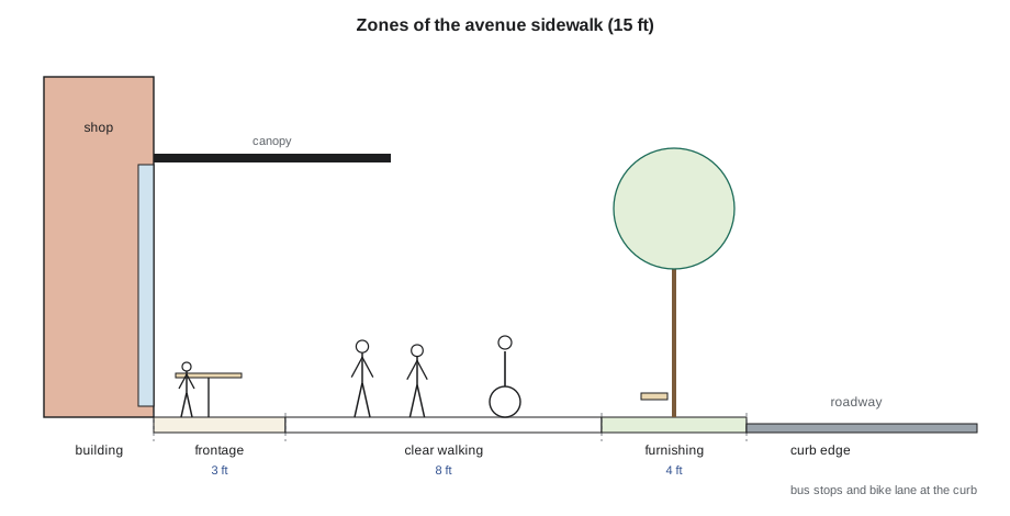
The sidewalk along the avenue in front of the site is 15 ft wide from the property line to the curb. That allows a frontage zone of about 3 ft, a clear walking zone of about 8 ft and a furnishing zone of about 4 ft. The building owns none of it; the sidewalk belongs to the city. But the building decides how the frontage zone is used, whether doors open onto it, whether a canopy shelters it, whether café tables spill into it and whether windows invite people to linger. A blank wall makes even a wide sidewalk feel empty; a row of open shopfronts can make a narrow one feel generous.
Blocks
Streets frame blocks. The size of a block determines how many routes a pedestrian has, how often they reach a corner, how many buildings can face a street and how lots can be subdivided. Small blocks of about 200 to 330 ft on a side, like those of Portland's downtown, which measure about 200 feet, give a fine-grained, walkable network with many corners and short walks. Large blocks of 650 ft or more force long detours and tend to fill with large single buildings or parking. Studies of walking in North American cities consistently find that the density of intersections, which rises as blocks get smaller, is one of the strongest predictors of how much people walk.
The blocks of the Minneapolis Warehouse District are irregular, shaped by the rivers, the railways and early land surveys, but most are between 260 and 430 ft on a side, with lanes running through them. The lanes are an important feature: they let deliveries, garbage and parking reach the backs of buildings without crossing the sidewalks, leaving the street fronts free for doors and windows.
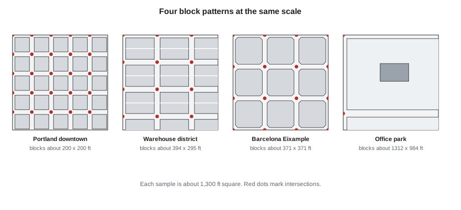
# Walkability of four block patterns over the same area (one square mile)
import math
area = 27878400                                   # square ft in one square mile
patterns = {
    # name: (block length, block width, street width), all in ft
    "Portland downtown": (200, 200, 66),
    "warehouse district": (394, 295, 80),
    "Barcelona Eixample": (371, 371, 66),
    "office park superblock": (1312, 984, 100),
}
for name, (a, b, s) in patterns.items():
    cell = (a + s) * (b + s)                    # one block plus half the streets around it
    blocks = area / cell
    intersections = blocks                      # one intersection per block on a regular grid
    street_share = 1 - (a * b) / cell
    frontage = blocks * 2 * (a + b)             # length of block edge facing streets
    print(f"{name:24s} {intersections:6.0f} intersections, streets take {100 * street_share:4.1f} of every 100 ft2, "
f"block frontage {frontage / 5280:5.1f} miles")Portland downtown 394 intersections, streets take 43.5 of every 100 ft2, block frontage 59.7 miles warehouse district 157 intersections, streets take 34.6 of every 100 ft2, block frontage 40.9 miles Barcelona Eixample 146 intersections, streets take 27.9 of every 100 ft2, block frontage 41.0 miles office park superblock 18 intersections, streets take 15.7 of every 100 ft2, block frontage 15.8 miles
The calculation shows the trade-offs. Portland's tiny blocks give about 400 intersections per square mile and the most street frontage, the most places for doors and shops, but streets take up more than two-fifths of the land. The office park has fewer than twenty intersections in the same area and about a quarter of the frontage. The warehouse district and Barcelona fall between: enough corners for an easy walk, enough frontage for continuous shops, and enough land inside each block for buildings with courtyards. Cerdà's Eixample, laid out in the 1860s, added another refinement: chamfered corners that widen every intersection into a small plaza, a feature that the corner of the studio site could echo in miniature.
Lots and grain
Within a block, land is divided into lots. Historic downtown lots were often narrow, 25 to 50 ft wide, because land was bought and built in small pieces; a warehouse might occupy two or three of them. The result was a fine grain: many buildings, many owners, many entrances and a constant variety along the street. Modern development tends to assemble lots into large parcels for single big buildings, which can be efficient but can also produce long, monotonous facades and a coarse grain.
The studio site was originally four lots of 33 ft each on the avenue, assembled and cleared in the 1960s for parking. Adeyemi asks the students to remember this. 'You may design one building, but the street should not read it as one undifferentiated block,' she says. 'Look at what forty meters of frontage looked like in 1915: four buildings, four doors, four rhythms.' The facade lesson will return to this question.
Corners
Corners are the most valuable and most visible parts of a block. They are seen from two streets and from a distance along each, they collect pedestrians from two directions, and they get light and air from two sides. In historic districts, corners held banks, hotels, taverns and shops, often with an entrance cut diagonally across the corner and a turret, dome or taller bay marking it. The studio site is a corner lot, and the corner of the avenue and Tessier Street is where its most public use and its most memorable form belong.
Corners also have practical rules. Cities often require a corner clear of tall objects so that drivers can see pedestrians, and they do not allow loading bays or garage entrances near intersections. Building at the corner usually means keeping the ground floor corner open and glazed, perhaps with a chamfer or a recess that widens the sidewalk where people wait to cross.
Lanes
The back lane is the building's service side. In the studio site's lane, garbage trucks collect from the Harland Building and the Coach House twice a week, delivery vans stop at the restaurants, and the artists in the Coach House load their work. The lane is where the studio building's loading, garbage and recycling, bike parking entrance and perhaps a few parking spaces should go, keeping the avenue and Tessier Street free of curb cuts.
Lanes can be more than service spaces. Several cities have improved lanes with paving, lighting, planting and small shops or studios that open onto them, turning them into intimate secondary streets. Minneapolis has improved several downtown alleys as shared spaces. For the Coach House artists, a lively, well-lit lane would be safer and more pleasant than a dark one. The students consider whether the Foundry Collective's workshop doors could open onto the lane, adding activity and allowing big deliveries.
Worked problem
Choosing the frontage for each use
The site has three edges facing public space: the avenue on the south, Tessier Street on the east and the lane on the north. The building needs a corner café, a grocery, a residential entrance, an entrance and freight access for the Foundry Collective, bike parking, loading and garbage. Wren assigns each use to an edge. How should she reason?
Show solution
- The avenue carries most pedestrians and gets the sun, so it should hold the most public and active uses: the café at the corner and the grocery along the rest of the frontage.
- Tessier Street is quieter, so it suits the residential lobby, where residents can come and go in a calmer setting, and the Foundry Collective's showroom and entrance, which can become a destination of its own.
- The lane suits loading, garbage, the bike room entrance and the Foundry Collective's freight door, keeping curb cuts and trucks off both streets.
- The corner itself should be glazed on both streets and might be chamfered to widen the sidewalk and mark the café entrance.
- No curb cut should cross the avenue sidewalk, and the residential entrance should be far enough from the corner to avoid queues from the café.
Answer: Matching uses to edges by the activity on each street keeps the public face lively, gives residents a dignified entrance and puts service where it disturbs the fewest people.
Exercise 2: street and block studies
This exercise takes one week.
- Draw the four blocks around the site and three comparison districts at the same scale, and count intersections and frontage.
- Draw sections through the avenue, Tessier Street and the lane at 1/16 in = 1 ft, with the existing buildings and a placeholder for the studio building, and calculate height-to-width ratios.
- Design the sidewalk zones along both street frontages, including trees, bike racks, café space and snow storage.
- Assign every use in the brief to an edge of the site and justify the choice in a short diagram.
Self-critique checklist
- Have I drawn the street as a room, with both sides?
- Does the most public use face the busiest edge?
- Have I kept loading and garbage off the streets?
- Have I considered winter: snow storage, sun and wind on the sidewalk?
Common mistakes
MistakeDesigning the building and ignoring the sidewalk.
InsteadDesign the frontage zone, the entrances and the canopy as part of the building.
MistakePlacing a garage entrance or loading bay on the main street.
InsteadUse the lane for service and keep curb cuts off the main streets.
MistakeTreating the corner like any other part of the frontage.
InsteadGive the corner the most public use and a distinctive form.
MistakeAssuming bigger blocks are more efficient for the city.
InsteadSmall blocks give more routes, corners and frontage, which support walking and shops.
MistakeForgetting the lane.
InsteadUse the lane for service and consider making it safer and more active.
Summary and key terms
- Streets are public rooms whose proportions, edges and activity determine how they feel.
- Height-to-width ratios near 1:1 feel enclosed and comfortable; very low ratios feel empty and very high ones canyon-like.
- Sidewalks have frontage, clear walking, furnishing and curb zones; the building shapes all of them through its ground floor.
- Smaller blocks give more intersections and frontage, and support walking.
- Corners deserve the most public uses; lanes keep service off the streets.
- Height-to-width ratio
- The ratio of the height of the buildings along a street to the width between their faces.
- Frontage zone
- The part of the sidewalk next to the buildings, used for café tables, displays and door swings.
- Pedestrian through zone
- The part of the sidewalk kept clear for walking.
- Furnishing zone
- The part of the sidewalk along the curb holding trees, lights and furniture.
- Grain
- The size and number of buildings and lots along a street; fine grain means many small ones.
- Chamfered corner
- A corner cut diagonally, widening the space at an intersection.
Practice problems
Work each problem on paper first, then reveal the answer to check.
Buildings of 60 ft face each other across a street 80 ft wide. What is the height-to-width ratio, and how does it feel?
Show answer
0.75, enclosed and comfortable.
A sidewalk is 13 ft wide. If the through zone must be 7 ft and the furnishing zone 4 ft, how wide is the frontage zone?
Show answer
2 ft.
Why do small blocks support walking?
Show answer
They give more intersections and route choices, shorter walks and more frontage for shops and entrances.
Why should loading go on the lane rather than the avenue?
Show answer
It keeps trucks and curb cuts off the busy sidewalk and leaves the street front for active uses.
What is the advantage of a chamfered corner?
Show answer
It widens the sidewalk at the intersection, gives space for waiting pedestrians and marks the corner.
Lesson quiz · 5 questions
Score 60% or more to complete this lesson.
Create a free account to save your progress, take quizzes and earn a certificate.