
ARCH-200 · Lesson 3 of 12 · 22 min
Landscape and topography
Joon-ho is sure the site is flat. He grew up on the prairie and has never seen a hill that was not made of garbage or snow. Haddad hands him a builder's level, a tripod and a measuring rod and sends him out with Ingrid. Two hours later they come back with forty spot elevations and a surprised look. The lot falls about 8 ft from its north-east corner, at the bus stop, to its south-west corner by the greenway. Most of that fall is invisible to the eye, spread across 230 ft, but it is enough to send all of the site's rainwater toward the oak and the back lane, to put the west end of any long building a full step below the east end, and to decide where the daycare's yard will drain. 'On the prairie,' Haddad says, 'a meter is a mountain.'
Reading the ground
Topography is the shape of the ground surface. On drawings it is shown with contours, lines joining points of equal elevation, usually at regular intervals called the contour interval. Where contours are close together the ground is steep; where they are far apart it is gentle. Contours never cross, and they bend upstream where they cross a valley or swale and downstream where they cross a ridge. A site survey usually gives spot elevations, measured heights at particular points, and the contours are drawn by interpolating between them.
Elevations are measured from a datum, a reference height. Surveys may use a geodetic datum, height above sea level, or a local site datum. The students use a local datum of 100.0 at the north-east corner of the lot, which makes the arithmetic easy: the south-west corner is at 92.0, the north-west corner at 95.0 and the south-east corner at 97.0. Using 100 rather than 0 avoids negative numbers when parts of the site, or the building's foundations, lie below the reference.
The slope of the ground is its rise or fall divided by the horizontal distance, often given as a ratio or a gradient. A fall of 5 ft over 230 ft is a gradient of about 1 in 47, or about 2.1 out of every 100. Slopes under about 1 in 50 feel flat; 1 in 20 is the steepest slope at which a walk can be built without being treated as a ramp in most accessibility codes; slopes around 1 in 12 are ramps; slopes over about 1 in 3 are hard to mow and need retaining or planting to hold the soil.
| Gradient | Out of 100 | What it means for design |
|---|---|---|
| 1 in 100 | 1 | Barely enough to drain paved surfaces |
| 1 in 50 | 2 | Feels flat; good for lawns, play areas and most paving |
| 1 in 20 | 5 | Maximum for an accessible walk without ramp features |
| 1 in 12 | 8.3 | Maximum for a ramp, with landings and handrails |
| 1 in 4 | 25 | Steep lawn; hard to mow, sledding hill |
| 1 in 2 | 50 | Needs planting, terracing or retaining to stay stable |
Drainage: where the water goes
The first purpose of studying topography is to understand drainage. Water runs downhill, perpendicular to the contours, and collects in low points. A building must shed water away from its walls and foundations, so the ground around it should fall away from it, typically at about 1 in 20 for the first 10 ft on soft landscape and at 1 in 50 or more on paving. Entrances should never be at a low point, and no path should send water toward a door.
On this site, the natural drainage runs from the corner by the bus stop toward the south-west, where water already ponds under the oak in spring. That is good for the tree but bad for a play yard. The students mark the low point, the flow lines and the areas that will need regrading. They also note that the old garage slab covers almost half the site, so most rain now runs off it as from a parking lot. Once the slab is removed, the soil will absorb some water, but the clay beneath absorbs it slowly.
Modern site design aims to manage stormwater on the site rather than sending it straight into the city sewer, which can overflow in heavy storms. Many cities charge for runoff or require new buildings to hold back part of it. Strategies include green roofs, rain gardens, which are shallow planted basins that hold water and let it soak in, bioswales, which are planted channels that slow and clean runoff, permeable paving, and underground storage tanks. A quick estimate of peak runoff uses the rational method, which multiplies a runoff coefficient for the surface, the rainfall intensity of a design storm and the area.
# Peak runoff by the rational method, before and after the hub is built
area_total = 37950                                  # lot area (sq ft)
surfaces_before = {"old slab and gravel": (0.55, 0.90), "weedy ground": (0.45, 0.35)}
surfaces_after = {"roof": (0.30, 0.95), "green roof": (0.08, 0.40), "paving": (0.15, 0.85),
                  "lawn and planting": (0.47, 0.25)}
intensity = 2.4                                   # design storm intensity (inches per hour)

def peak(surfaces):
    c = sum(share * coef for share, coef in surfaces.values())
    return c, c * intensity * area_total / 43_560

for name, s in (("before", surfaces_before), ("after", surfaces_after)):
    c, q = peak(s)
    print(f"{name:<7} weighted C = {c:.2f}, peak runoff = {q:.3f} cfs")

# Rain garden to hold the first 1 in of rain falling on the paved and roofed areas
hard = area_total * (0.30 + 0.15)
volume = hard * 1 / 12
print(f"Rain garden storage for that rain: {volume:,.0f} cu ft")before weighted C = 0.65, peak runoff = 1.364 cfs after weighted C = 0.56, peak runoff = 1.175 cfs Rain garden storage for that rain: 1,423 cu ft
The hub with a green roof over part of the building and generous planting produces slightly less peak runoff than the old slab, even though it covers more of the site with roof. The students decide to place a rain garden along the greenway edge, where the ground is already lowest and where it can be planted with native grasses and wildflowers. It will collect water from the roofs and paths, keep it away from the oak's trunk and make the edge of the site a small piece of prairie.
Cut, fill and the level of the floor
A building needs level floors, and the ground rarely is. Setting the floor level, often written as the finished floor elevation, is one of the first decisions that ties a building to its site. If the floor is set high, soil must be brought in, or fill placed, around the low parts of the building; if it is set low, soil must be dug out, or cut, around the high parts. Earthmoving costs money and disturbs roots and drainage, so designers try to balance cut and fill, reusing excavated soil on site.
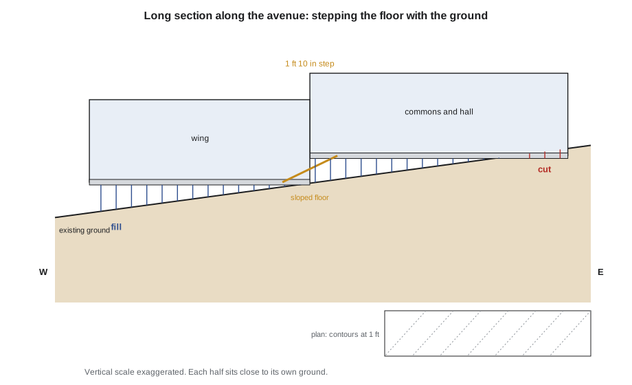
There are three common ways to fit a long building onto a sloping site. The building can sit on a single level, with the ground cut away at the high end and filled at the low end. It can step, with floors at two or more levels joined by stairs, ramps or gently sloping floors. Or it can float above the ground on columns or a crawlspace, leaving the ground undisturbed. On this site, the fall along the avenue is about 5 ft over the length of the buildable area, too much to ignore but too little to justify a full story of difference.
# Cut and fill for a level building pad, by the grid method
# Existing ground is close to a plane: 5.0 ft fall from east to west over 230 ft,
# 3.0 ft fall from north to south over 165 ft, with 100.0 at the north-east corner.
W, D, step = 230, 165, 2.0

def ground(x, y):            # x measured west from the east lot line, y south from the avenue
    return 100.0 - 5.0 * x / W - 3.0 * y / D

# Pad for the building: 204 x 70 ft, set back 10 from Marlow Street and 10 from the avenue
def earthwork(level):
    cut = fill = 0.0
    nx, ny = int(204 / step), int(70 / step)
    for i in range(nx):
        for j in range(ny):
            x, y = 10 + (i + 0.5) * step, 10 + (j + 0.5) * step
            dz = ground(x, y) - level
            if dz > 0:
                cut += dz * step * step
            else:
                fill += -dz * step * step
    return cut, fill

for level in (96.0, 96.75, 97.5):
    c, f = earthwork(level)
print(f"pad at {level:.2f}: cut {c:7.0f} cu ft, fill {f:7.0f} cu ft, net {c - f:+7.0f} cu ft")pad at 96.00: cut 14365 cu ft, fill 3698 cu ft, net +10668 cu ft pad at 96.75: cut 8112 cu ft, fill 8154 cu ft, net -42 cu ft pad at 97.50: cut 3670 cu ft, fill 14422 cu ft, net -10752 cu ft
A single level pad near the middle of the range balances cut and fill, but the numbers hide a problem: the east end would sit in a shallow trench below the sidewalk at the bus stop, while the west end would stand well above the ground of the daycare yard. Callum suggests splitting the building into two levels about 1 ft 10 in apart, with the step taken by a gently sloping floor in the central commons. Each half then sits close to its own ground, entrances at both ends are almost level with the outside, and the earthwork shrinks. Haddad likes the idea and asks him to test it in section during the massing studies.
Landscape as part of the design
Landscape architecture is a profession of its own, and on a building of this size a landscape architect will be part of the design team. Architecture students should nonetheless learn to think of the ground and its planting as part of the design from the start, not as leftover space to be filled in at the end. The spaces between and around buildings are where people arrive, wait, play, gather and pass through; in a community building they can be as important as the rooms.
The students list the outdoor spaces the hub needs: a sheltered forecourt at the corner by the bus stop; the daycare play yard, fenced and sunny, with shade from the oak; a public path following the desire line from the corner toward the greenway; a small plaza or terrace off the hall for summer events; a community garden, which the neighborhood association has asked for; service access and a loading area for the kitchen and hall; bicycle parking; and a modest amount of car parking and drop-off space. Each needs a place on the site with the right sun, shelter, slope and relationship to the building.
- The forecourt should be level with the entrance, sunny and out of the north-west wind.
- The play yard needs gentle slopes for running, a small mound for climbing and sliding, soft surfaces under equipment and good drainage.
- The public path should not exceed 1 in 20 so that it is accessible without ramps.
- The garden needs full sun, water and good soil, which may have to be imported over the old fill.
- Service access should come from the back lane or the side street, away from the entrance and the yard.
Planting for a cold climate
Planting choices depend on hardiness, the ability of a plant to survive winter cold. The site is in a cold hardiness zone where many ornamental trees common farther south will not survive. Native species, such as bur oak, green ash, which is now threatened by the emerald ash borer, basswood, hackberry, chokecherry, saskatoon or serviceberry, and prairie grasses such as big bluestem and little bluestem, are well adapted and support local wildlife. A row of spruce or other evergreens on the north-west side of an outdoor space can act as a windbreak; a windbreak reduces wind speed for a distance of several times its height downwind.
Planting also has a social role. A community garden gives neighbors a reason to come to the hub in summer, and the daycare can use part of it. Trees along the avenue give the building a civic frontage and shade the sidewalk. The rain garden along the greenway can be a teaching landscape, with small signs naming the prairie plants. Wren proposes moving the community garden onto the hall's flat roof to free ground for the yard, but the class concludes that the cost of a structure strong enough for soil, and the difficulty of getting water and tools up there, make the ground the better place.
Worked problem
Keeping the desire line accessible
The diagonal desire line runs about 245 ft from the bus stop at elevation 100.0 to the greenway near the oak at about 93.1. Callum wants the public path to pass through the hub's commons, where the floor slopes 1 ft 10 in over 37 ft between the two halves of the building. Is the whole route accessible without ramps?
Show solution
- The average gradient outside is 6.9 / 245 ≈ 1 in 35, gentle enough for an accessible walk.
- The sloped commons floor has a gradient of 1.83 / 37 ≈ 1 in 20.2, just gentler than 1 in 20, so it is a sloped floor rather than a ramp.
- The steepest part of the outdoor path will be where it leaves the higher east forecourt; it must be graded to stay at 1 in 20 or gentler there too.
- The straight diagonal would cross the oak's protection zone, so the path should bend east of the zone near the greenway.
- The bend lengthens the route slightly, which also eases its gradient.
Answer: Yes. With a bend around the oak's root zone and careful grading at the forecourt, the route from the bus stop through the commons to the greenway stays at 1 in 20 or gentler throughout.
Exercise 3: grading the site
- Plot the spot elevations on the base plan and draw contours at 1 ft intervals.
- Draw arrows showing the existing drainage and mark low points and ponding areas.
- Propose floor levels for a simple massing block and calculate cut and fill for at least two options.
- Draw two site sections, one along the avenue and one from the avenue to the greenway, with existing and proposed ground lines.
- Locate the outdoor spaces listed above and check the slope of each path.
- Estimate peak runoff before and after, and size a rain garden for the first inch of rain on the hard surfaces.
Self-critique checklist
- Does the ground fall away from the building on every side?
- Are all public paths 1 in 20 or gentler, or designed as ramps where they are steeper?
- Have I kept grading, paving and trenches out of the oak's protection zone?
- Do my sections show the ground accurately, including below the building?
Common mistakes
MistakeAssuming a site that looks flat is flat.
InsteadSurvey it; a small fall decides drainage, floor levels and access.
MistakeSetting one floor level for a long building on a slope without checking the ends.
InsteadCheck every entrance level and consider stepping the floor.
MistakeDrawing contours that cross or end in the middle of the site.
InsteadContours are continuous lines of equal elevation and never cross.
MistakeSending water toward doors or into the root zone of a protected tree.
InsteadGrade away from buildings and around trees.
MistakeTreating landscape as leftover space.
InsteadDesign outdoor spaces with the same care as rooms, from the first sketches.
Summary and key terms
- Contours and spot elevations describe topography; slope is rise over run.
- Drainage should flow away from buildings and entrances; stormwater is increasingly managed on site with rain gardens, swales and green roofs.
- Setting the floor level balances cut and fill and ties every entrance to the ground.
- Long buildings on slopes can sit on one level, step, or float above the ground.
- Outdoor spaces, planting and grading are part of the architectural design.
- Contour
- A line joining points of equal elevation.
- Datum
- A reference height from which elevations are measured.
- Cut and fill
- Soil removed from high areas and placed in low areas to reshape the ground.
- Rain garden
- A shallow planted basin that collects stormwater and lets it soak in.
- Runoff coefficient
- The fraction of rain that runs off a surface rather than soaking in.
- Hardiness
- A plant's ability to survive winter cold.
Practice problems
Work each problem on paper first, then reveal the answer to check.
Ground falls 2 ft over 100 ft. What is the gradient?
Show answer
1 in 50, or 2 out of every 100.
Why should entrances not be placed at low points?
Show answer
Water collects there and would flow toward or into the door, and ice forms in winter.
What is the advantage of a local site datum of 100 rather than 0?
Show answer
It avoids negative elevations for points below the reference.
A path rises 4 ft along its length. How long must it be to stay at 1 in 20?
Show answer
80 ft.
Name two ways to reduce stormwater runoff from a new building.
Show answer
A green roof and a rain garden; permeable paving and bioswales also help.
Lesson quiz · 5 questions
Score 60% or more to complete this lesson.
Create a free account to save your progress, take quizzes and earn a certificate.