
BIOL-440 · Lesson 8 of 12 · 24 min
Arctic ecosystems
North of the treeline lies the Arctic tundra, a treeless world of dwarf shrubs, sedges, mosses and lichens over permafrost, bordered by an ocean that freezes each winter. The Arctic seems barren, yet in summer it teems with breeding birds, insects, caribou, foxes and lemmings, and its seas support whales, seals, walrus and polar bears. It is also warming faster than any other region on Earth. This lesson describes Arctic tundra and polar deserts, the role of permafrost and thermokarst, the sea-ice ecosystem, Arctic food webs, and the greening, thawing and ice loss now under way.
Tundra and polar desert
The Arctic tundra extends from the treeline to the coasts of the Arctic Ocean and the Arctic islands. Ecologists divide it into the low Arctic, with continuous cover of shrubs such as dwarf birch, willows and ericaceous shrubs over sedge tussocks and mosses, and the high Arctic, with sparse plants in a matrix of bare ground, grading into polar deserts on the northernmost islands where precipitation may be below 100 millimetres a year and plants grow only in sheltered, moist patches. The Circumpolar Arctic Vegetation Map divides the region into five bioclimate subzones from A in the far north to E near the treeline, with summer warmth roughly doubling from one end to the other.
Arctic plants are low-growing, which keeps them in the warmer air near the ground and under the protection of winter snow. Many are perennial and slow-growing, store nutrients and carbohydrates in roots and rhizomes, and reproduce clonally as much as by seed. Cushion plants such as moss campion trap heat; flowers of Arctic poppies and mountain avens track the sun like parabolic dishes, warming their reproductive parts and attracting insects. The growing season may be only six to ten weeks, but continuous summer daylight lets photosynthesis continue around the clock. Nutrient supply, especially nitrogen, limits growth as much as temperature does, because decomposition in cold, wet soils is slow; fertilization experiments at Toolik Lake in Alaska and elsewhere have shown that adding nitrogen and phosphorus favours shrubs and grasses at the expense of mosses and lichens.
Tundra landscapes are patterned by frost. Repeated freezing and thawing sorts soil into circles, polygons and stripes. Ice wedges grow in cracks that open in the frozen ground each winter and fill with meltwater each spring, producing polygonal networks visible from the air, with low-centred polygons where wedges push up rims and high-centred polygons where wedges have begun to melt. Pingos, ice-cored hills up to tens of metres high, form where water freezes beneath drained lakes; the Tuktoyaktuk Peninsula in the Northwest Territories has the world's greatest concentration of them.
Permafrost thaw and thermokarst
Lesson 2 introduced permafrost. In the Arctic tundra it is continuous and often ice-rich, so warming is visible on the land. Thermokarst lakes form as ground ice melts and the surface subsides into water-filled depressions that then expand by thawing their banks. Retrogressive thaw slumps, horseshoe-shaped scars on slopes where ice-rich permafrost is exposed and melts back each summer, have multiplied on the Peel Plateau and around the Mackenzie Delta in the Northwest Territories and in northern Alaska, delivering sediment to streams and lakes. Coastal erosion, where thawing bluffs meet longer open-water seasons and storms, is retreating some Arctic shorelines by several metres a year, threatening communities such as Tuktoyaktuk in Canada and Shishmaref and Kivalina in Alaska.
Arctic food webs
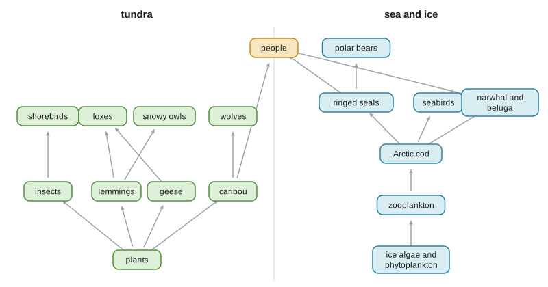
Arctic food webs are relatively simple, with few species at each level, which makes them sensitive to changes in any key species. On land, lemmings and voles are the main small herbivores and their cycles of three to five years drive the breeding of predators such as Arctic foxes, snowy owls, rough-legged hawks and jaegers. Caribou and muskoxen are the large herbivores. Geese have become important herbivores in some areas: lesser snow geese, whose populations grew enormously over the late twentieth century as they fed on agricultural grain during winter, have degraded large areas of coastal salt marsh around Hudson Bay by grubbing for roots.
In the marine system, ice algae growing on the underside of sea ice, and phytoplankton blooms at the ice edge in spring, form the base of the food web. They feed copepods and other zooplankton, which feed Arctic cod, a key forage fish, which in turn feed seals, seabirds, narwhal and beluga. Ringed seals give birth in snow lairs on the sea ice and are the main prey of polar bears, which hunt from the ice. Walrus feed on clams on shallow sea floors and rest on ice floes between dives. Inuit and other coastal peoples harvest many of these species, and country food remains central to health, culture and food security in northern communities.
Sea ice and polar bears
Arctic sea ice expands each winter to about 14 to 15 million square kilometres and shrinks to a September minimum that has fallen from about 7 million square kilometres in the early satellite years around 1980 to roughly 4 to 5 million in recent years, a decline of more than 12 per cent per decade, with the record low in 2012. Ice is also thinner and younger: the multiyear ice that once dominated the central Arctic has largely been replaced by seasonal ice. For species that depend on ice as a platform, loss of ice is loss of habitat.
Polar bears are the emblem of this change. They hunt seals from sea ice and fast through the ice-free season on land. In Western Hudson Bay, one of the best-studied populations, the ice-free season has lengthened by several weeks since the 1980s, so bears come ashore earlier and in poorer condition and must fast longer. Aerial surveys estimated about 618 bears there in 2021, down roughly 27 per cent from 2016 and about half of the population in the 1980s, with declines concentrated in young bears and females. Other populations, especially in the high Arctic where thicker ice is becoming seasonal, are stable or even benefiting for now. Polar bears are listed as a species of special concern under Canada's Species at Risk Act and as threatened under the United States Endangered Species Act since 2008, the first species listed mainly because of projected habitat loss from climate change.
Arctic amplification
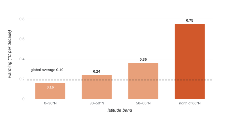
The Arctic is warming much faster than the globe as a whole, a phenomenon called Arctic amplification. An analysis by Mika Rantanen and colleagues, published in 2022, found that from 1979 to 2021 the Arctic north of the Arctic Circle warmed nearly four times faster than the global average. Several feedbacks contribute: as snow and sea ice retreat, darker land and ocean absorb more sunlight; the atmosphere near the surface is stably layered in the Arctic, so warming stays near the ground; more water vapour and clouds trap heat; and heat carried poleward by the atmosphere and ocean increases.
The albedo feedback is easy to estimate. Fresh snow reflects 80 to 90 per cent of sunlight, tundra without snow about 15 to 20 per cent, and a shrub canopy that sticks up through the snow perhaps 30 to 40 per cent in spring because dark stems mask the snow beneath. Taller shrubs therefore warm the surface in spring even before the snow melts, which speeds melt and lengthens the growing season, a positive feedback.
# Spring albedo change from shrub expansion: extra absorbed solar energy (illustrative values).
import numpy as np
days = np.arange(90, 152)                               # April and May
solar = 120 + 150 * np.sin(np.pi * (days - 80) / 200)   # W per m2 incoming at the surface, illustrative
snow_cover = np.clip(1 - (days - 120) / 25, 0, 1)        # snowmelt between day 120 and 145
def albedo(shrub_frac):
    snow_alb = 0.82 * (1 - shrub_frac) + 0.35 * shrub_frac   # shrubs protruding through snow
    bare_alb = 0.18
    return snow_cover * snow_alb + (1 - snow_cover) * bare_alb
for f in (0.0, 0.2, 0.5):
    absorbed = (1 - albedo(f)) * solar
    print(f"shrub cover {f:.0%}: mean spring albedo {albedo(f).mean():.2f}, mean absorbed {absorbed.mean():5.1f} W/m2")
extra = ((1 - albedo(0.5)) * solar - (1 - albedo(0.0)) * solar).mean()
print(f"extra energy absorbed with 50% shrub cover: {extra:.1f} W/m2 averaged over April-May")shrub cover 0%: mean spring albedo 0.62, mean absorbed 84.4 W/m2 shrub cover 20%: mean spring albedo 0.56, mean absorbed 96.7 W/m2 shrub cover 50%: mean spring albedo 0.46, mean absorbed 115.3 W/m2 extra energy absorbed with 50% shrub cover: 30.9 W/m2 averaged over April-May
Tens of watts per square metre in spring is a large local forcing, many times the global average forcing from doubling carbon dioxide. Across the whole Arctic the effect is smaller because shrub expansion is patchy, but studies on Alaska's North Slope and in Yukon have suggested that shrub expansion could add measurably to regional summer warming, while also changing snow distribution, which can warm soils in winter.
Arctic greening and browning
Satellite records since the 1980s show greening of much of the Arctic tundra, rising values of the Normalized Difference Vegetation Index from BIOL-430, consistent with longer, warmer growing seasons and the expansion of shrubs, documented on the ground by repeat photographs in northern Alaska taken decades apart and by plot studies across the tundra. Willows and alders are spreading upslope and along streams, and the treeline is advancing in some places, though slowly and patchily, because seed supply, permafrost, browsing and soil conditions limit tree establishment. Some areas have instead browned, after extreme events such as winter warm spells that kill evergreen shrubs, insect outbreaks, drought and fire. Tundra fires were historically rare, but the 2007 Anaktuvuk River fire on Alaska's North Slope burned about 1,000 square kilometres and released carbon accumulated over decades, and tundra fires have become more frequent in recent hot summers.
# Estimating Arctic amplification from synthetic annual temperature anomalies, 1979-2021.
import numpy as np
from scipy import stats
rng = np.random.default_rng(808)
yrs = np.arange(1979, 2022)
glob = 0.019 * (yrs - 1979) + rng.normal(0, 0.10, yrs.size)       # degrees C, global mean anomaly
arct = 0.074 * (yrs - 1979) + rng.normal(0, 0.55, yrs.size)       # Arctic mean anomaly: larger trend and noise
g, a = stats.linregress(yrs, glob), stats.linregress(yrs, arct)
print(f"global trend {10 * g.slope:.2f} C/decade (SE {10 * g.stderr:.2f}); Arctic trend {10 * a.slope:.2f} C/decade (SE {10 * a.stderr:.2f})")
ratio = a.slope / g.slope
boot = []
for _ in range(2000):
    i = rng.integers(0, yrs.size, yrs.size)
    boot.append(stats.linregress(yrs[i], arct[i]).slope / stats.linregress(yrs[i], glob[i]).slope)
lo, hi = np.percentile(boot, [2.5, 97.5])
print(f"amplification ratio {ratio:.1f} (bootstrap 95% interval {lo:.1f} to {hi:.1f})")global trend 0.18 C/decade (SE 0.01); Arctic trend 0.81 C/decade (SE 0.07) amplification ratio 4.4 (bootstrap 95% interval 3.5 to 5.5)
Because Arctic temperatures vary much more from year to year than the global mean, the ratio is uncertain even over four decades, and published estimates range from about three to four depending on the period, the dataset and how the Arctic is defined; this synthetic series happens to land a little above that range, with a wide interval. The central finding, that the Arctic warms several times faster than the globe, is robust across all of them.
Worked problem
How much faster is the Arctic warming?
A regression of annual mean temperature on year gives a trend of 0.74 °C per decade for the Arctic and 0.19 °C per decade for the globe over the same period. Calculate the amplification ratio and the total warming over 40 years in each region.
Show solution
- Amplification ratio = 0.74 / 0.19 = 3.9.
- Arctic warming over 40 years = 0.74 x 4 = 3.0 °C.
- Global warming over 40 years = 0.19 x 4 = 0.76 °C.
- The Arctic has warmed nearly four times as fast, about 3 °C versus under 1 °C.
Answer: An amplification ratio of about 3.9, with about 3.0 °C of Arctic warming against 0.8 °C globally over 40 years.
Common mistakes
MistakeDescribing the Arctic as lifeless.
InsteadSummer brings abundant plants, insects, breeding birds and mammals, and its seas are highly productive.
MistakeAttributing Arctic amplification to one cause.
InsteadAlbedo, lapse-rate, water vapour, cloud and heat-transport feedbacks all contribute.
MistakeAssuming all polar bear populations are declining equally.
InsteadWestern Hudson Bay has declined, while some high Arctic populations are stable for now.
MistakeEquating greening with a healthier Arctic.
InsteadShrub expansion lowers albedo, changes snow and habitat, and can harm lichen-dependent caribou.
MistakeIgnoring nutrient limitation in tundra.
InsteadNitrogen and phosphorus limit growth as much as temperature does.
Summary and key terms
- The Arctic tundra runs from the treeline to polar deserts, divided into bioclimate subzones by summer warmth.
- Arctic plants are low, perennial and nutrient-limited; frost patterns the ground into polygons and pingos.
- Thermokarst lakes, thaw slumps and coastal erosion are visible signs of permafrost thaw.
- Food webs are simple; lemming cycles drive terrestrial predators, and ice algae and Arctic cod underpin the marine web.
- September sea ice has fallen by more than 12 per cent per decade; Western Hudson Bay polar bears have declined.
- The Arctic has warmed nearly four times faster than the globe since 1979, with greening, shrub expansion and more tundra fire.
- tundra
- Treeless northern or alpine vegetation of dwarf shrubs, sedges, mosses and lichens.
- polar desert
- Very dry, sparsely vegetated high Arctic terrain.
- ice wedge
- A vertical wedge of ice that grows in repeatedly refilled frost cracks, forming polygons.
- pingo
- An ice-cored hill formed by freezing water in permafrost.
- retrogressive thaw slump
- A slope failure that retreats as exposed ice-rich permafrost melts.
- ice algae
- Algae growing on and in sea ice, a base of the Arctic marine food web.
- Arctic amplification
- Faster warming in the Arctic than the global average.
- albedo feedback
- Warming that reduces snow and ice, lowering albedo and causing further warming.
- shrubification
- The expansion of shrubs into tundra.
- country food
- Food from hunting, fishing and gathering on the land and sea.
Practice problems
Work each problem on paper first, then reveal the answer to check.
Why are Arctic plants low-growing?
Show answer
To stay in warmer air near the ground and under protective snow.
What are low-centred and high-centred polygons?
Show answer
Ice-wedge polygons; high-centred ones indicate wedges that have begun to melt.
Name the forage fish central to the Arctic marine food web.
Show answer
Arctic cod.
Why is sea ice loss especially harmful to polar bears?
Show answer
They hunt seals from the ice and must fast longer when the ice-free season lengthens.
If the Arctic warms at 0.6 °C per decade and the globe at 0.2 °C, what is the amplification ratio?
Show answer
3.
How do shrubs change spring albedo?
Show answer
Dark stems protrude through snow and lower albedo, increasing absorbed energy.
Give one sign of permafrost thaw visible on the land.
Show answer
Thermokarst lakes, thaw slumps or eroding coastal bluffs.
Why has lesser snow goose grazing damaged Hudson Bay salt marshes?
Show answer
Their populations grew with winter agricultural food, and they grub roots of marsh plants.
Lesson quiz · 5 questions
Score 60% or more to complete this lesson.
Create a free account to save your progress, take quizzes and earn a certificate.