
BIOL-440 · Lesson 10 of 12 · 23 min
Resource development and northern landscapes
The boreal forest and Arctic hold timber, oil, gas, minerals and rivers that can generate electricity, and their development has shaped northern economies and landscapes for more than a century. Development brings jobs, revenue and infrastructure, often welcomed by northern communities, and also cumulative ecological effects that build up as projects multiply across a landscape. This lesson looks at forestry, the energy sector and its linear features, hydroelectric reservoirs and mercury, mining, and the tools used to assess and manage cumulative effects and to restore disturbed land.
Forestry in the boreal forest
Commercial forestry in the boreal forest harvests mainly spruce, jack pine, balsam fir and aspen for lumber, pulp and paper, and, increasingly, bioenergy. Most harvest is by clearcutting, which removes most trees from a cutblock, followed by natural regeneration or planting. Because boreal forests are adapted to stand-replacing fire, foresters have argued that clearcutting, done carefully, can emulate natural disturbance. Natural disturbance-based management tries to make harvest patterns resemble fire: varying cutblock sizes, leaving patches of unharvested trees and snags inside cutblocks as fire does, protecting stream buffers, and maintaining a range of stand ages across the landscape that matches what the fire regime would produce.
But clearcutting differs from fire in important ways. Fire leaves standing dead trees and charred wood, burns patchily, consumes part of the organic layer, and does not build roads. Harvest removes wood, compacts soil, leaves an organic layer that favours different regeneration, and requires roads that persist and give access to hunters, predators and further development. Over decades, harvest combined with fire can shorten the average age of the forest and reduce old forest below what the natural regime would maintain, with consequences for caribou, old-forest birds, lichens and fungi.
Most Canadian boreal forest is publicly owned by the provinces, which license companies to harvest under forest management plans, sustainable forest management requirements and reforestation obligations. Canada harvests roughly 0.3 per cent of its managed forest area each year, compared with a much larger area burned or affected by insects in most years. A large share of Canada's managed forest is certified under third-party standards such as those of the Forest Stewardship Council (FSC), the Sustainable Forestry Initiative and the Canadian Standards Association, which add requirements for biodiversity, Indigenous rights and community engagement. FSC Canada's national standard, revised in recent years, includes specific requirements for caribou habitat and for free, prior and informed consent from Indigenous peoples.
Energy development and linear features
Oil and gas development has transformed parts of the western boreal forest and the Arctic coastal plain. In northeastern Alberta, the oil sands underlie about 140,000 square kilometres, and surface mining has cleared and excavated forest, peatland and wetlands across a large area north of Fort McMurray, while most of the deposit is extracted in place by steam injection from well pads connected by roads and pipelines. Across the western boreal forest, exploration has cut seismic lines, straight corridors cleared to carry equipment for seismic surveys, at densities that can exceed several kilometres per square kilometre. Alberta alone is estimated to have hundreds of thousands of kilometres of seismic lines.
Linear features have effects out of proportion to their area. A 5-metre-wide seismic line removes little forest, but it fragments habitat, channels predators, gives access to people on all-terrain vehicles and snowmobiles, changes snow and drainage, and, in peatlands, often fails to regrow trees for decades because the compacted, wet ground favours sedges and shrubs. Caribou avoid areas near roads and well sites, and, as lesson 7 showed, wolves travel along lines and kill caribou more often. Ecologists therefore measure cumulative disturbance by buffering features, commonly by 500 metres in caribou analyses, and calculating the share of a range affected.
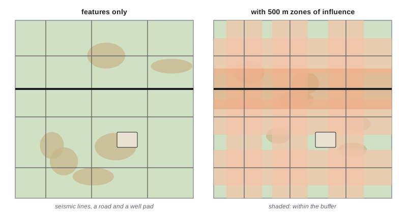
# Footprint versus buffered disturbance from synthetic seismic lines on a 20 km x 20 km landscape.
import numpy as np
rng = np.random.default_rng(1010)
size, cell = 20_000, 50                                  # m; 50 m grid cells
n = size // cell
xs = np.arange(n) * cell + cell / 2
X, Y = np.meshgrid(xs, xs)
lines_x = rng.uniform(0, size, 9)                        # north-south lines
lines_y = rng.uniform(0, size, 7)                        # east-west lines
length_km = (len(lines_x) + len(lines_y)) * size / 1000
density = length_km / (size / 1000) ** 2
footprint = length_km * 1000 * 6 / size**2               # 6 m wide lines
d = np.minimum(np.min(np.abs(X[..., None] - lines_x), axis=-1), np.min(np.abs(Y[..., None] - lines_y), axis=-1))
for buf in (100, 250, 500):
    print(f"buffer {buf:>3} m: {100 * np.mean(d <= buf):5.1f}% of landscape within the zone of influence")
print(f"line length {length_km:.0f} km, density {density:.2f} km per km2, cleared footprint {100 * footprint:.2f}%")
print(f"undisturbed share with 500 m buffers: {100 * np.mean(d > 500):.0f}% (federal caribou threshold: 65%)")buffer 100 m: 15.4% of landscape within the zone of influence buffer 250 m: 34.6% of landscape within the zone of influence buffer 500 m: 57.1% of landscape within the zone of influence line length 320 km, density 0.80 km per km2, cleared footprint 0.48% undisturbed share with 500 m buffers: 43% (federal caribou threshold: 65%)
The cleared area is under half a per cent, yet more than half of the landscape lies within 500 metres of a line, leaving only about 43 per cent undisturbed, far below the 65 per cent threshold in the federal boreal caribou recovery strategy. Real landscapes are more complex, with fire, roads, cutblocks and well pads added, but the arithmetic explains why disturbance thresholds are crossed quickly in developed ranges and why restoring existing lines is a priority.
Restoring disturbed land
Seismic line restoration aims to regrow forest and block predator and human travel. Techniques include mounding, which creates raised microsites where conifer seedlings can grow above the wet peat; planting black spruce and tamarack seedlings; felling or bending trees across lines, sometimes called silviculture or line blocking; and leaving coarse woody debris. Programs in Alberta and British Columbia, often with Indigenous partners, have treated thousands of kilometres, and monitoring shows reduced wolf use of treated lines, but trees take decades to grow tall enough to restore habitat fully. Oil sands mine reclamation is far harder: companies must reclaim land to an equivalent land capability, yet creating functioning peatlands on reshaped tailings and overburden is an experimental science, with pilot fens built in the 2010s still being evaluated. Tailings ponds containing process water, bitumen residue and naphthenic acids cover large areas, and their reclamation and the release of treated water remain unresolved issues.
Hydroelectric reservoirs and mercury
Large hydroelectric projects have flooded vast areas of boreal forest and peatland in Quebec, Manitoba, Labrador and northern Ontario, and smaller ones exist in Alaska. Reservoirs change rivers from flowing to still water, alter fish communities, block fish migrations, change downstream flows and estuaries, and displace communities and harvesting areas. A surprising and serious effect emerged after the James Bay project of the 1970s and 1980s: mercury in fish rose sharply in new reservoirs. Flooded soils and vegetation decompose, and bacteria convert inorganic mercury, naturally present in soils and deposited from the atmosphere, into methylmercury, which accumulates up food chains. Predatory fish such as northern pike and walleye in new reservoirs often have mercury concentrations several times higher than in natural lakes for 20 to 30 years, posing risks to people who eat them.
# Methylmercury in reservoir fish after flooding: rise and slow decline (synthetic, illustrative).
import numpy as np
years = np.arange(0, 41)
baseline = 0.4                                            # mg/kg mercury in pike in natural lakes
peak_extra, t_peak, decay = 1.6, 8, 0.11                  # extra mercury, years to peak, decline rate after peak
extra = np.where(years <= t_peak, peak_extra * years / t_peak, peak_extra * np.exp(-decay * (years - t_peak)))
hg = baseline + extra
guideline = 0.5                                           # common consumption guideline for commercial fish, mg/kg
above = years[hg > guideline]
print(f"peak mercury {hg.max():.2f} mg/kg at year {years[np.argmax(hg)]}, {hg.max() / baseline:.1f} times baseline")
print(f"years above {guideline} mg/kg guideline: {above.min()} to {above.max()} ({above.max() - above.min() + 1} years)")
for y in (5, 10, 20, 30):
print(f"year {y:>2}: {hg[y]:.2f} mg/kg")peak mercury 2.00 mg/kg at year 8, 5.0 times baseline years above 0.5 mg/kg guideline: 1 to 33 (33 years) year 5: 1.40 mg/kg year 10: 1.68 mg/kg year 20: 0.83 mg/kg year 30: 0.54 mg/kg
The experience of the Cree of Eeyou Istchee with mercury after the La Grande projects led to fish consumption advisories, health monitoring and compensation, and shaped later agreements such as the 2002 Paix des Braves between the Cree and Quebec. When the Muskrat Falls project in Labrador was planned, Inuit of Nunatsiavut and researchers predicted that methylmercury would increase downstream in Lake Melville, a fjord used for fishing and seal hunting, and called for clearing soils and vegetation from the reservoir before flooding; disputes over these measures were a major issue before the reservoir was filled in 2019 and 2020.
Mining and cumulative effects
Mining for gold, diamonds, uranium, nickel, copper, iron and critical minerals is a major northern industry. Diamond mines in the Northwest Territories, gold mines in Nunavut and Yukon, the Red Dog zinc mine in Alaska, and iron and nickel mines in Quebec and Labrador have brought jobs and revenue, and also legacy problems. The Giant Mine near Yellowknife left about 237,000 tonnes of arsenic trioxide dust stored underground, which must be kept frozen indefinitely, a remediation costing billions of dollars. Interest in critical minerals for batteries and clean energy has renewed exploration across the North, from the Ring of Fire in Ontario to proposed copper and cobalt projects in Alaska, raising questions about roads into roadless regions and about consent of Indigenous communities.
Individually, a mine, a road or a seismic program may have modest effects; together they accumulate. Cumulative effects assessment tries to evaluate the combined effects of past, present and reasonably foreseeable activities on valued components such as caribou, water or fish, rather than judging each project alone. Tools include disturbance thresholds, regional land-use plans that set limits on development in zones, regional assessments, and monitoring programs. In practice cumulative effects management has often lagged behind development, partly because no single project triggers a limit and because authority is divided among governments and agencies.
| Activity | Main ecological effects | Mitigation and restoration |
|---|---|---|
| Forestry | Younger forest, roads, loss of old-forest habitat | Natural disturbance-based harvest, retention, road closure, certification |
| Seismic lines and pipelines | Fragmentation, predator travel, slow regrowth in peat | Low-impact narrow lines, mounding, planting, line blocking |
| Oil sands mining | Loss of forest and peatland, tailings, water use | Reclamation to equivalent capability, constructed fens |
| Hydroelectric reservoirs | Flooding, altered flows, methylmercury in fish | Site clearing before flooding, advisories, flow management |
| Mining | Habitat loss, contamination, roads, legacy waste | Closure planning, financial security, long-term water treatment |
Worked problem
How much undisturbed habitat remains?
A caribou range of 6,000 km2 has burned areas under 40 years old covering 900 km2 and human features whose 500 m buffers cover 2,100 km2, with 300 km2 of overlap between the two. What percentage of the range is disturbed, and does it meet the 65 per cent undisturbed threshold?
Show solution
- Total disturbed area = 900 + 2,100 − 300 (overlap counted once) = 2,700 km2.
- Disturbed share = 2,700 / 6,000 = 45 per cent.
- Undisturbed share = 55 per cent.
- 55 per cent is below the 65 per cent threshold, so the range does not meet it; about 600 km2 would need to be restored or allowed to recover.
Answer: 45 per cent disturbed, 55 per cent undisturbed, below the 65 per cent threshold by about 600 km2.
Common mistakes
MistakeJudging linear features by the area they clear.
InsteadTheir zone of influence, buffered by hundreds of metres, matters far more than their footprint.
MistakeAssuming clearcutting is ecologically equivalent to fire.
InsteadHarvest removes wood, builds roads and leaves different soil conditions; it can emulate some features of fire but not all.
MistakeTreating reservoir mercury as a short-term problem.
InsteadMethylmercury in fish typically stays elevated for 20 to 30 years after flooding.
MistakeAssessing each project alone.
InsteadCumulative effects assessment considers past, present and foreseeable activities together.
MistakeExpecting reclamation to restore peatlands quickly.
InsteadConstructed fens and seismic line restoration are slow and still experimental in many settings.
Summary and key terms
- Forestry, energy, hydroelectricity and mining shape northern landscapes and economies.
- Natural disturbance-based forest management tries to emulate fire, but harvest and fire differ in key ways.
- Seismic lines, roads and pipelines have zones of influence far larger than their footprint.
- Restoration of seismic lines and reclamation of oil sands mines are slow and partly experimental.
- New reservoirs raise methylmercury in fish for decades, affecting people who rely on fish.
- Cumulative effects assessment and regional land-use planning address the combined effects of many projects.
- natural disturbance-based management
- Forest management that tries to make harvest patterns resemble natural disturbance such as fire.
- clearcutting
- Harvesting most trees from an area at once.
- seismic line
- A straight corridor cleared for seismic exploration of oil and gas.
- zone of influence
- The area around a feature within which it affects wildlife or ecosystems.
- line blocking
- Placing felled or bent trees across linear features to slow travel by predators and people.
- equivalent land capability
- The reclamation standard requiring disturbed land to support uses similar to those before disturbance.
- tailings
- Waste material left after extracting a resource, often stored in ponds.
- methylmercury
- An organic, highly toxic form of mercury that accumulates in food webs.
- cumulative effects
- The combined effects of multiple past, present and foreseeable activities.
- certification
- Third-party verification that forest management meets a standard.
Practice problems
Work each problem on paper first, then reveal the answer to check.
Why can a 5 m wide seismic line affect caribou over a much wider area?
Show answer
It channels wolves and people, alters habitat and is avoided by caribou, so its zone of influence is hundreds of metres.
Name two ways clearcutting differs from wildfire.
Show answer
For example, it removes wood, builds roads, compacts soil and leaves the organic layer intact.
What is mounding in seismic line restoration?
Show answer
Creating raised microsites so conifer seedlings can grow above wet peat.
Why does mercury rise in fish after flooding a reservoir?
Show answer
Decomposing flooded soils and plants let bacteria convert mercury to methylmercury, which accumulates up the food chain.
A 4,000 km2 range has 1,800 km2 disturbed. Does it meet the 65 per cent undisturbed threshold?
Show answer
No; it is 55 per cent undisturbed.
What is cumulative effects assessment?
Show answer
Evaluating the combined effects of past, present and foreseeable activities on valued components.
Why is the Giant Mine remediation so costly?
Show answer
About 237,000 tonnes of arsenic trioxide must be kept frozen underground indefinitely.
What does forest certification add to legal requirements?
Show answer
Third-party standards for biodiversity, Indigenous rights and community engagement.
Lesson quiz · 5 questions
Score 60% or more to complete this lesson.
Create a free account to save your progress, take quizzes and earn a certificate.