
BIOL-440 · Lesson 1 of 12 · 24 min
The circumboreal biome
The boreal forest wraps around the top of the Northern Hemisphere in a broad band of conifers, birch and aspen, bogs and lakes, broken by rivers and burned patches of every age. It is the largest land biome on Earth after the tundra-and-desert complex, and it holds a large share of the world's forest carbon, much of it underground in cold soils and peat. This course looks at how the boreal forest and the Arctic beyond it work, how fire, insects, frozen ground and long winters shape them, how northern animals live through cycles of plenty and scarcity, how Indigenous peoples have lived with and managed these lands for thousands of years, and how resource development and a fast-warming climate are changing them. This first lesson defines the biome, its climate and its boundaries, and introduces the research station whose data we will use throughout.
Where the boreal forest is
Boreal comes from Boreas, the Greek god of the north wind. The circumboreal forest, also called taiga from a Russian word for the northern forest, stretches across Russia, Fennoscandia, Alaska and Canada, roughly between latitudes 50 and 70 degrees north, though its edges bend with climate: it reaches far south in the cold continental interiors of Siberia and Canada and stays far north along mild coasts such as Norway. Russia holds the largest share, about half of the world's boreal forest. Canada holds about a quarter, and Natural Resources Canada describes a boreal zone of about 552 million hectares, roughly 55 per cent of the country's land area, of which about 270 million hectares is forest and the rest is wetland, lakes, rock and other land.
In Canada the boreal zone runs from the Yukon and northern British Columbia across the northern Prairie provinces, northern Ontario and Quebec to Labrador and Newfoundland. About 3.7 million people live in it, many in Indigenous communities, and it overlaps the traditional territories of hundreds of First Nations and Métis communities. Its southern edge meets the aspen parkland and grasslands in the Prairies and the mixed Great Lakes–St. Lawrence forest in Ontario and Quebec; its northern edge grades into the taiga shield and the forest–tundra and then the Arctic tundra. Canadian ecologists classify this region into ecozones, among them the Boreal Plains, Boreal Shield, Taiga Plains, Taiga Shield and Hudson Plains, each with distinctive geology and drainage that you met in BIOL-208.
Throughout the course we follow a research team at the invented Sable River Boreal Research Station. The station sits in a watershed of spruce forest, jack pine sand plains, aspen stands, fens and bogs, with a fire history mapped back several decades and a caribou range at its northern edge.
In this version of the course the station is near La Ronge in north-central Saskatchewan, on the Boreal Shield where granite outcrops, lakes and black spruce lowlands alternate. The team, led by Dr. Mira Lindqvist with graduate students Jonah Pelletier (fire), Ama Mensah (wildlife) and Kai Nakamura (peatlands), works with the land guardian program of a neighbouring First Nation, whose guardians monitor caribou, water and fire on their territory. All data in this course are synthetic and seeded, built to behave like real boreal data, and the people and station are invented.
A climate of long winters
The boreal climate is subarctic: long, very cold winters and short, mild to warm summers. In the Köppen system most of the boreal forest falls in the Dfc and Dfd classes, continental climates in which at most three months average above 10 °C. Mean January temperatures of −20 to −30 °C are common in the continental interior, and extremes below −45 °C occur. Summers are short but can be hot; days are long, approaching 20 hours of daylight at 60 degrees north near the solstice, which partly compensates for the brief season. Precipitation is modest, often 300 to 600 millimetres a year, with a summer maximum in the continental interior. Because evaporation is low in the cold, even this modest precipitation leaves soils wet in poorly drained terrain, which is why peatlands are so widespread.
The northern limit of trees, the treeline, coincides broadly with the position of the summer Arctic front and with a mean July temperature near 10 °C, a correlation noticed by early biogeographers and still a useful rule of thumb. At the global scale, alpine and Arctic treelines both sit where mean growing-season temperature is around 6 to 7 °C, which suggests that cold limits tree growth, the formation of new tissue, more than it limits photosynthesis. Growing degree-days, the sum over the season of daily mean temperature above a base such as 5 °C, are a compact index of the warmth available for growth and are used to map boreal subzones.
# Growing season indices for a synthetic year at the Sable River station (La Ronge-like climate).
import numpy as np
rng = np.random.default_rng(101)
day = np.arange(365)
mean_annual, amplitude = -0.5, 18.5          # degrees C; coldest near day 15, warmest near day 197
temp = mean_annual - amplitude * np.cos(2 * np.pi * (day - 15) / 365) + rng.normal(0, 3.5, 365)
gdd5 = np.clip(temp - 5, 0, None).sum()
above10 = [m for m in range(12) if temp[m * 30:(m + 1) * 30].mean() > 10]
frost_free = np.diff(np.flatnonzero(np.r_[True, temp <= -2, True])).max() - 1
print(f"mean annual temperature {temp.mean():.1f} C, coldest month {min(temp[m*30:(m+1)*30].mean() for m in range(12)):.1f} C")
print(f"growing degree-days above 5 C: {gdd5:.0f}")
print(f"months averaging above 10 C: {len(above10)}  (boreal climates have at most 3)")
print(f"longest run of days above -2 C: {frost_free} days")mean annual temperature -0.7 C, coldest month -18.5 C growing degree-days above 5 C: 1213 months averaging above 10 C: 3 (boreal climates have at most 3) longest run of days above -2 C: 157 days
Totals near 1,000 to 1,300 growing degree-days are typical of the central boreal forest. By comparison, a southern Ontario or Ohio farm field accumulates more than 2,500. The same calculation run on decades of station records shows the warming trend discussed in lesson 11: in much of the North the growing season now starts earlier and ends later than it did in the mid-twentieth century.
Zones within the biome
The boreal biome is not uniform. From south to north ecologists recognize a sequence of subzones. The southern boreal or mixedwood zone has productive forests of aspen, balsam poplar, white spruce and balsam fir on fine-textured soils, grading into hardwood forests or parkland at its southern edge. The main or middle boreal zone is dominated by black spruce and jack pine on poorer soils, with extensive peatlands. The northern boreal or open lichen woodland has widely spaced black spruce over a carpet of reindeer lichens, the classic winter range of barren-ground and woodland caribou. The forest–tundra ecotone, sometimes 100 or more kilometres wide, is a mosaic of stunted spruce in sheltered sites and tundra on exposed ones, giving way to the treeless Arctic tundra described in lesson 8.
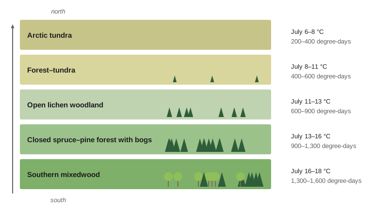
Elevation and aspect produce similar sequences over short distances. On mountains in the Yukon or Alaska, the forest gives way to shrub and alpine tundra with height, and in interior Alaska the contrast between warm south-facing slopes with aspen and birch and cold north-facing slopes with black spruce over permafrost is one of the most striking patterns in the biome. Topography also controls drainage, and drainage controls whether a site becomes upland forest, a fen fed by mineral-rich groundwater or a bog fed only by rain.
Why the boreal forest matters globally
The boreal forest matters far beyond its own borders. It stores a very large pool of carbon, estimated in the hundreds of billions of tonnes, most of it in soils, peat and permafrost rather than trees; estimates vary widely with methods, but the boreal biome is generally ranked as the largest terrestrial carbon store per unit area once soils are included. Its dark conifer canopy absorbs sunlight and warms the regional climate in winter and spring compared with snow-covered tundra, an albedo effect that partly offsets its carbon uptake and that we quantify in lesson 8. It feeds rivers that carry fresh water and organic carbon to the Arctic Ocean and Hudson Bay. It is the breeding ground for an estimated one to three billion birds, many of which winter in the United States, Mexico and South America, so that changes in the boreal forest are felt in backyards across the Americas. And it supports forestry, mining, hydroelectric and oil and gas industries along with the hunting, trapping and fishing on which northern communities depend.
| Region | Share of world boreal forest | Dominant trees | Characteristic features |
|---|---|---|---|
| Russia | About half | Larch, Scots pine, spruce, birch | Vast deciduous larch forests over continuous permafrost in eastern Siberia |
| Canada | About a quarter | Black and white spruce, jack pine, aspen, balsam fir | Extensive peatlands, frequent large crown fires, many lakes on the Canadian Shield |
| Alaska (United States) | About 2 to 3 per cent | Black and white spruce, paper birch, aspen | Permafrost on north slopes and lowlands, frequent large fires, rapid warming |
| Fennoscandia | A few per cent | Scots pine, Norway spruce, birch | Long history of intensive forestry; few large fires today |
Comparisons across the biome are instructive. Siberian larch forests are deciduous conifers that drop their needles in winter and dominate the coldest, driest continental interiors with continuous permafrost. North American boreal forests burn mainly in intense stand-replacing crown fires, while many Eurasian boreal forests burn in lower-intensity surface fires that leave trees alive, a difference linked to tree species and their traits, which lesson 4 explores. Fennoscandian forests have been managed intensively for centuries, so old-growth structure, dead wood and the species that depend on them are rare there, a warning for regions where industrial forestry is younger.
Studying a biome
Boreal ecology relies on long-term plots, remote sensing and partnerships. The vastness and remoteness of the biome mean that satellite records, from Landsat imagery since 1972 to the newer Sentinel and MODIS products, are essential for mapping fire, vegetation change and snow. Field stations with decades of records anchor these observations: in Canada, the Kluane Lake Research Station and the long-running boreal forest work in the Yukon, the Experimental Lakes Area in northwestern Ontario and research forests in Quebec and Alberta; in Alaska, the Bonanza Creek Long-Term Ecological Research site near Fairbanks, part of the United States LTER network. Indigenous knowledge holders bring observations across many generations of land use, and community-based monitoring programs increasingly combine both kinds of knowledge, as lesson 9 discusses. Field methods themselves were covered in BIOL-430; this course concentrates on what those methods have revealed about the North.
Worked problem
Placing a site in its biome
A station records a mean annual temperature of about −1 °C, three months with mean temperature above 10 °C, about 1,150 growing degree-days above 5 °C, and a forest of black spruce and jack pine with scattered aspen. Classify the climate and boreal subzone, and name one feature you would expect in poorly drained parts of the landscape.
Show solution
- At most three months above 10 °C and a cold winter place the climate in Köppen Dfc, subarctic continental.
- About 1,150 growing degree-days and black spruce–jack pine dominance indicate the main or middle boreal zone rather than the southern mixedwood.
- Low evaporation means water accumulates in poorly drained depressions, so peatlands, bogs and fens, are expected there.
Answer: A subarctic Dfc climate in the middle boreal zone, with peatlands in poorly drained terrain.
Common mistakes
MistakeTreating the boreal forest as an unbroken mass of spruce.
InsteadIt is a mosaic of forest of many ages, wetlands, lakes and burns, shaped by fire, drainage and permafrost.
MistakeAssuming most boreal carbon is in trees.
InsteadMost is in soils, peat and permafrost, which is why disturbance of the ground matters so much.
MistakeUsing latitude alone to define the biome.
InsteadClimate, especially summer warmth and continentality, sets its limits, which bend far south in cold interiors and north along mild coasts.
MistakeAssuming North American and Eurasian boreal forests behave alike.
InsteadSpecies and fire regimes differ, for example crown fires in North America and more surface fires in parts of Eurasia.
MistakeIgnoring people in a supposedly wild biome.
InsteadThe boreal forest is home to many Indigenous communities and has been used and managed for thousands of years.
Summary and key terms
- The circumboreal forest spans Russia, Fennoscandia, Alaska and Canada, roughly between 50 and 70 degrees north, with Canada holding about a quarter.
- Its subarctic climate has long cold winters, short warm summers, modest precipitation and low evaporation.
- The treeline coincides broadly with a mean July temperature near 10 °C and growing-season temperatures of about 6 to 7 °C.
- Subzones run from southern mixedwood through closed spruce–pine forest and lichen woodland to the forest–tundra and tundra.
- Most boreal carbon is stored in soils, peat and permafrost, and the dark canopy affects regional climate through albedo.
- Long-term stations, remote sensing and Indigenous knowledge together underpin boreal research.
- boreal forest
- The circumpolar northern forest of conifers, birch, aspen and wetlands, also called taiga.
- taiga
- A Russian-derived name for the boreal forest, sometimes used for its open northern part.
- treeline
- The northern or upper limit beyond which trees do not grow in upright form.
- growing degree-days
- The seasonal sum of daily mean temperature above a base temperature, an index of warmth for growth.
- subarctic climate
- A continental climate with long, very cold winters and short summers, Köppen Dfc or Dfd.
- forest–tundra ecotone
- The broad transition zone where stunted trees in sheltered sites alternate with tundra.
- lichen woodland
- Open northern forest of widely spaced spruce over a ground layer of reindeer lichens.
- mixedwood
- Southern boreal forest mixing broadleaf trees such as aspen with conifers such as white spruce.
- ecozone
- A large ecological region defined by landforms, climate, soils and biota, used in Canadian classification.
- albedo
- The fraction of incoming sunlight a surface reflects.
Practice problems
Work each problem on paper first, then reveal the answer to check.
Name the four main regions of the circumboreal forest.
Show answer
Russia, Fennoscandia, Alaska and Canada.
What does a Köppen Dfc climate tell you?
Show answer
A cold continental climate with a snowy winter and at most three months above 10 °C, typical of the boreal forest.
Why are peatlands widespread despite modest precipitation?
Show answer
Low evaporation in the cold and poor drainage leave soils waterlogged.
What mean July temperature roughly marks the northern treeline?
Show answer
About 10 °C.
Give one reason the boreal forest matters to people far to the south.
Show answer
For example, its carbon storage affects global climate, or it breeds birds that winter in the south.
A site has 600 growing degree-days and widely spaced spruce over lichens. Which subzone is it in?
Show answer
The northern open lichen woodland.
Why is the contrast between north- and south-facing slopes so strong in interior Alaska?
Show answer
South slopes receive much more solar radiation and lack permafrost; north slopes are cold and underlain by permafrost.
Where is most boreal carbon stored?
Show answer
In soils, peat and permafrost.
Lesson quiz · 5 questions
Score 60% or more to complete this lesson.
Create a free account to save your progress, take quizzes and earn a certificate.