
BIOL-440 · Lesson 5 of 12 · 24 min
Peatlands and northern wetlands
Seen from the air, much of the boreal forest is not forest at all. Bogs, fens, ponds and lakes fill the hollows between ridges and cover vast flat lowlands, and in parts of northern Canada and Alaska wetlands occupy more than half of the land. Peatlands, wetlands where dead plant material accumulates faster than it decays, are the most important of these. They store a disproportionate share of the world's soil carbon, regulate water flows, emit methane, support distinctive plants and animals and are increasingly affected by drainage, roads, mining and permafrost thaw. This lesson explains how peatlands form and work, measures their carbon, and introduces the animals, especially beavers, that engineer northern wetlands. Aquatic food webs of lakes and rivers are left to BIOL-460.
What makes a peatland
Peat forms where the production of plant matter exceeds its decomposition, usually because waterlogging keeps the soil short of oxygen and cold temperatures and acidity slow microbes further. Over thousands of years, peat accumulates at rates of roughly 0.2 to 1 millimetre per year, so a peatland 3 metres deep may have taken 5,000 to 10,000 years to form. Most northern peatlands began forming after the retreat of the ice sheets, between about 12,000 and 8,000 years ago, often by the infilling of shallow lakes or by paludification, the waterlogging and peat growth that spreads across poorly drained forest soils. Canada's wetland classification defines peatlands as having at least 40 centimetres of peat; shallower wetlands include marshes, swamps and shallow open water.
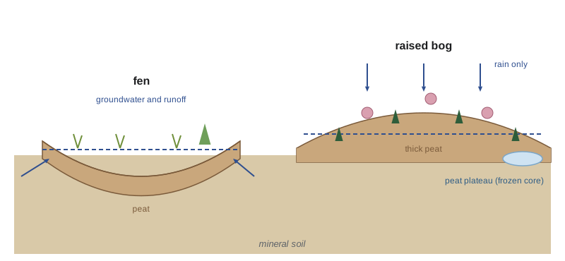
Peatlands fall into two broad types, defined by where their water comes from. Fens receive water that has flowed through or over mineral soil, groundwater or surface runoff, so they are less acidic and richer in nutrients and support sedges, brown mosses, shrubs and often tamarack. Bogs have built up so far above the surrounding water table that they receive water and nutrients only from precipitation; they are acidic, often with a pH below 4.5, and nutrient-poor, and they are dominated by Sphagnum mosses, ericaceous shrubs such as Labrador tea and leatherleaf, and stunted black spruce. Many peatlands change from fen to bog as peat accumulates and the surface rises above the influence of groundwater.
Sphagnum: the peat builder
Sphagnum mosses are often called ecosystem engineers because they create the conditions that favour themselves. Their cell walls contain compounds that resist decay, their large dead hyaline cells hold many times their weight in water, and they acidify their surroundings by exchanging hydrogen ions for nutrient cations. The result is a wet, acidic, nutrient-poor environment in which few vascular plants thrive and decomposition is very slow. Bog surfaces form a microtopography of drier hummocks and wetter hollows occupied by different Sphagnum species. Carnivorous plants such as pitcher plants and sundews, which obtain nitrogen from insects, are characteristic of these nutrient-poor surfaces, and a peat bog's pH, water table and vegetation are tightly linked.
Within peat, ecologists distinguish an upper acrotelm, where the water table fluctuates and oxygen enters at times, so decomposition is relatively fast, and a lower catotelm, permanently waterlogged and anoxic, where decomposition slows to a trickle. Most peat that survives the acrotelm is effectively preserved in the catotelm for millennia, which is why peat cores record past vegetation, climate, fire and even atmospheric lead from the industrial era.
Peatland carbon
Northern peatlands cover only about 3 per cent of the world's land surface but store an estimated 400 to 550 billion tonnes of carbon, often summarized as roughly a quarter to a third of all soil carbon, although estimates vary with mapping methods and depth. Canada holds the largest area of peatland of any country after Russia, much of it in the Hudson Bay Lowlands of Ontario and Manitoba, which form one of the largest continuous peatland complexes in the world, along with large peatland regions in the Mackenzie basin and northern Alberta, Saskatchewan and Quebec. Alaska and the western Great Lakes states also have extensive peatlands, including the large patterned peatlands of northern Minnesota around Red Lake.
# Peat carbon stock and long-term accumulation rate from a synthetic core (Sable River fen-to-bog sequence).
import numpy as np
rng = np.random.default_rng(55)
depth_top = np.arange(0, 300, 10) / 100              # 10 cm slices to 3 m, depths in m
bd = np.clip(0.06 + 0.035 * depth_top + rng.normal(0, 0.008, depth_top.size), 0.04, None)   # g/cm3
c_frac = np.clip(0.47 + rng.normal(0, 0.015, depth_top.size), 0.4, 0.55)
stock = (0.10 * bd * 1000 * c_frac).sum()            # kg C per m2 (thickness 0.10 m, bd in kg/m3)
basal_age = 8200                                     # calibrated radiocarbon age at the base, years
print(f"total carbon stock: {stock:.0f} kg C per m2 ({stock * 10:.0f} t C per ha)")
print(f"mean long-term carbon accumulation: {stock * 1000 / basal_age:.0f} g C per m2 per year")
print(f"mean vertical peat accumulation: {3000 / basal_age:.2f} mm per year")
area_km2 = 120                                        # peatland area in the watershed
print(f"carbon in {area_km2} km2 of similar peatland: {stock * area_km2 * 1e6 / 1e9:.1f} million tonnes")total carbon stock: 158 kg C per m2 (1581 t C per ha) mean long-term carbon accumulation: 19 g C per m2 per year mean vertical peat accumulation: 0.37 mm per year carbon in 120 km2 of similar peatland: 19.0 million tonnes
A long-term average carbon accumulation rate of around 15 to 30 grams per square metre per year is typical of northern peatlands. That is small per year, but over millennia and millions of square kilometres it built one of the planet's largest carbon reservoirs. The present-day carbon balance of a peatland, measured with flux towers and chambers, varies from year to year: wet, cool years tend to favour accumulation, while drought, fire and drainage can turn peatlands into carbon sources as the acrotelm dries and oxygen reaches old peat.
Methane
Peatlands are also the largest natural source of methane in the northern latitudes. In waterlogged, anoxic peat, methanogenic archaea produce methane as the final step of decomposition, and it escapes by diffusion, by ebullition as bubbles, or through the aerenchyma, the air channels, of sedges and other wetland plants. Methane is a much more powerful greenhouse gas than carbon dioxide over short timescales, about 80 times more powerful over 20 years and about 28 to 30 times over 100 years. Fens with high water tables and sedges usually emit more methane than drier bogs. Emissions rise steeply with temperature, a relationship described by the Q10 coefficient, the factor by which a rate increases for a 10 °C rise.
# Temperature dependence of methane flux with a Q10 model, and the effect of a warmer summer (synthetic).
import numpy as np
F_ref, T_ref = 60.0, 10.0                            # mg CH4 per m2 per day at 10 C peat temperature
Q10 = 3.0                                            # typical of wetland methane production
days = np.arange(150)                                # May to September
T_now = 4 + 10 * np.sin(np.pi * days / 150)          # peat temperature at 10 cm, degrees C
flux_now = F_ref * Q10 ** ((T_now - T_ref) / 10)
flux_warm = F_ref * Q10 ** ((T_now + 2 - T_ref) / 10)
print(f"season total now: {flux_now.sum() / 1000:.1f} g CH4 per m2")
print(f"season total if peat is 2 C warmer: {flux_warm.sum() / 1000:.1f} g CH4 per m2 (+{100 * (flux_warm.sum() / flux_now.sum() - 1):.0f}%)")
print(f"CO2-equivalent over 100 years (GWP 28): {flux_warm.sum() * 28 / 1000:.0f} g CO2e per m2")season total now: 9.9 g CH4 per m2 season total if peat is 2 C warmer: 12.3 g CH4 per m2 (+25%) CO2-equivalent over 100 years (GWP 28): 345 g CO2e per m2
The model ignores the water table, which matters as much as temperature: a warmer but drier summer can lower methane emissions while raising carbon dioxide losses. Real projections couple temperature, water table, vegetation and permafrost. Still, the calculation explains why scientists watch northern wetlands closely in a warming climate.
Peatlands and permafrost
In the discontinuous permafrost zone, permafrost survives mainly beneath peat plateaus and palsas, raised peat mounds whose insulating peat keeps the ground frozen. As the climate warms or fires remove the insulating moss, these frozen cores thaw and collapse into wet, sedge-dominated collapse scar bogs and fens. Studies in the southern Northwest Territories, northern Alberta and interior Alaska have documented the loss of a large share of peat plateau area since the mid-twentieth century. Thaw changes hydrology, tree cover, carbon and methane fluxes: thawed sites often emit more methane, and newly flooded margins can release old carbon, while new Sphagnum growth slowly accumulates peat again.
Beavers, engineers of northern wetlands
The North American beaver (Castor canadensis) is the most important animal engineer of boreal wetlands. By damming streams, beavers flood forests, create ponds and meadows, raise water tables, trap sediment and increase wetland area and habitat diversity for waterfowl, amphibians, fish and moose. Beaver ponds store water during droughts and can act as firebreaks; studies have shown green, wet corridors of beaver-modified streams persisting through severe fires. Beavers were trapped to near extinction in much of their range during the fur trade, which shaped the economy and exploration of northern North America, and their recovery over the twentieth century has transformed many landscapes.
Beavers are now expanding north onto the Arctic tundra of Alaska and the western Canadian Arctic, where satellite imagery shows thousands of new ponds since about 2000, apparently enabled by longer ice-free seasons and expanding shrubs that provide food and building material. Their dams flood tundra, thaw permafrost beneath ponds and alter streams used by fish, with consequences that researchers and northern communities are only beginning to understand.
| Wetland type | Water source | Typical vegetation | Methane |
|---|---|---|---|
| Bog | Precipitation only | Sphagnum, ericaceous shrubs, black spruce | Low to moderate |
| Fen | Groundwater and runoff | Sedges, brown mosses, tamarack, shrubs | Moderate to high |
| Peat plateau or palsa | Precipitation; frozen core | Lichens, shrubs, black spruce | Low while frozen |
| Collapse scar | Thawed permafrost and runoff | Sedges, Sphagnum | High |
| Beaver pond and marsh | Impounded stream water | Emergent plants, flooded trees | High in new ponds |
Threats and protection
Canadian peatlands face drainage and excavation for horticultural peat, mostly in Quebec, New Brunswick, Alberta and Manitoba; disturbance by oil sands mining, roads, seismic lines and pipelines in Alberta; hydroelectric flooding in Quebec, Manitoba and Labrador; and mining interest in the Hudson Bay Lowlands. In Ontario's Ring of Fire, a chromite and nickel deposit beneath the Lowlands, road and mine proposals have been debated for more than a decade. In June 2025 Ontario passed Bill 5, the Protect Ontario by Unleashing our Economy Act, which allows cabinet to designate special economic zones exempt from some provincial rules and replaced the province's Endangered Species Act with a narrower Species Conservation Act; the province has said the Ring of Fire would become such a zone only after consultation, and several Treaty 9 First Nations have opposed the law or vowed legal challenges. Peatland scientists warn that disturbing the Lowlands could release large amounts of carbon.
Worked problem
Peat accumulation and age
Kai dates a basal peat sample at 2.4 m depth to 6,000 years before present. Estimate the mean vertical accumulation rate and the age expected at 1.2 m if accumulation was constant, and explain why the true age at 1.2 m may be younger than that.
Show solution
- Mean rate = 2,400 mm / 6,000 years = 0.4 mm per year.
- At constant rate, 1,200 mm accumulated in 1,200 / 0.4 = 3,000 years, so the expected age is about 3,000 years.
- Older peat has been compressed by overlying peat and has decomposed longer, so a given thickness near the base represents more time than the same thickness near the top.
- The age at 1.2 m is therefore likely younger than 3,000 years; an age–depth model from several dates is needed.
Answer: About 0.4 mm per year and an expected 3,000 years at 1.2 m, but compaction means the true age there is likely younger.
Common mistakes
MistakeCalling every wetland a bog.
InsteadBogs are fed only by precipitation; fens receive groundwater and runoff and differ in chemistry and plants.
MistakeAssuming peatlands always take up carbon.
InsteadDrought, fire, drainage and thaw can turn them into carbon sources.
MistakeComparing methane and carbon dioxide mass for mass.
InsteadMethane is about 28 to 30 times more potent over 100 years and about 80 times over 20 years.
MistakeTreating Q10 models as complete predictions.
InsteadWater table, vegetation and substrate matter as much as temperature.
MistakeSeeing beavers only as nuisances.
InsteadBeavers create wetlands, store water and support biodiversity, though their northward spread brings new effects.
Summary and key terms
- Peat forms where waterlogging, cold and acidity slow decomposition below plant production, at roughly 0.2 to 1 mm per year.
- Fens are fed by groundwater and are richer; bogs are fed only by precipitation and are acidic and Sphagnum-dominated.
- Northern peatlands store hundreds of billions of tonnes of carbon, roughly a quarter to a third of soil carbon.
- Wet, anoxic peat emits methane, whose flux rises steeply with temperature and water table.
- Peat plateaus hold permafrost that is thawing into collapse scars, changing carbon and methane fluxes.
- Beavers engineer northern wetlands and are spreading onto the Arctic tundra.
- peatland
- A wetland where peat, partly decomposed plant material, has accumulated, at least 40 cm deep in Canadian usage.
- bog
- A peatland fed only by precipitation, acidic and nutrient-poor.
- fen
- A peatland fed by groundwater or runoff, less acidic and richer in nutrients.
- paludification
- The spread of waterlogging and peat formation over formerly drier soils.
- Sphagnum
- Peat mosses that acidify and waterlog their surroundings and build bogs.
- acrotelm
- The upper peat layer where the water table fluctuates and decomposition is faster.
- catotelm
- The lower, permanently waterlogged peat layer where decomposition is very slow.
- Q10
- The factor by which a rate increases with a 10 °C rise in temperature.
- palsa
- A raised peat mound with a permafrost core.
- ecosystem engineer
- An organism that creates or modifies habitat, such as Sphagnum or the beaver.
Practice problems
Work each problem on paper first, then reveal the answer to check.
What distinguishes a bog from a fen?
Show answer
A bog receives water only from precipitation; a fen also receives groundwater or runoff.
Why does peat accumulate in the catotelm for millennia?
Show answer
It is permanently waterlogged and anoxic, so decomposition is extremely slow.
A peat layer 0.2 m thick has bulk density 90 kg/m3 and 48 per cent carbon. What is its carbon stock?
Show answer
0.2 x 90 x 0.48 = 8.6 kg C per m2.
With Q10 = 2, how much does a rate change with a 5 °C warming?
Show answer
2^(0.5) = 1.41, an increase of about 41 per cent.
Name two pathways by which methane leaves a wetland.
Show answer
Diffusion, ebullition (bubbles) or transport through plant aerenchyma.
Why do peat plateaus collapse when they thaw?
Show answer
Their frozen cores contain ice; when it melts the surface subsides and floods.
Give one way beavers benefit boreal ecosystems.
Show answer
For example, creating wetlands, storing water through droughts or providing fire refugia.
Where is one of the largest continuous peatland complexes in the world?
Show answer
The Hudson Bay Lowlands of Ontario and Manitoba.
Lesson quiz · 5 questions
Score 60% or more to complete this lesson.
Create a free account to save your progress, take quizzes and earn a certificate.