
ARCH-301 · Lesson 2 of 12 · 25 min
Program and site
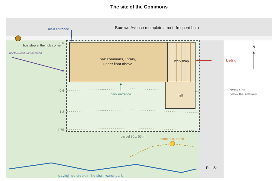
In the second week Hartmann takes the studio to the site on a cold, bright morning. The bus drops them at the new stop at the hub corner, and they walk east along the avenue past the shops whose fronts survived the half-finished road widening of the 1960s. One block on, the street wall stops. To the south the land falls away into the rail yard, which the city has bought and is beginning to turn into the stormwater park drawn in the urban design course. A fence still runs along the avenue, and behind it a few lengths of rail lie in the snow. The parcel for the Commons is the north-east corner of the yard: 80 m along the avenue and 55 m deep, with a quiet side street, Pell Street, on its east side and the new park to the south and west. Somewhere under the snow at the bottom of the slope is the creek that the park will bring back to the surface.
Hartmann gives the students an hour on the site with three instructions. Find the lowest and highest points and estimate the difference. Find where the sun is at noon and where the wind is coming from. And find where a person getting off the bus would expect the front door to be. Ingrid paces the slope and estimates a fall of about 1.8 m from the avenue sidewalk to the edge of the future park path. Joon-ho stands at the bus stop and points down the avenue: the door should be visible from here, he says, and no more than a minute's walk away. Wren notices that the north-west wind, the one that matters in January, comes straight across the open yard and hits the avenue sidewalk where the building will stand. Callum photographs the old rails and the brick foundations of a shed that once stood on the site.
Reading the site again
The students analysed this district at a larger scale in the urban design course, and Hartmann does not want them to repeat that work. What she wants now is the site analysis that a building needs: the facts that will decide where the building sits, how high its floor is, where its doors are and what its walls must do. She gives them a checklist that she has used in practice for twenty years, and asks them to fill it in for the Commons before drawing anything.
- Boundaries and dimensions: the legal lot, easements, the build-to line and the setbacks of the zoning.
- Levels: existing grades, the level of the avenue sidewalk, the level of the park paths and the design flood level.
- Ground: the soil, the depth to firm bearing, the groundwater level and any contamination from the rail yard.
- Services: where the water main, sanitary sewer, storm sewer, electrical service and fibre run, and how deep they are.
- Climate: sun angles, the prevailing and the coldest winds, where snow drifts and where it is cleared to.
- Movement: the bus stop, the bike lanes, the pedestrian routes from the hub and the housing, the delivery route and the fire department's access.
- Neighbours and views: the shops on the avenue, the houses to the north, the park and the creek, and what each sees of the building.
Several of these items come from documents rather than walks. Natarajan supplies a survey, a geotechnical report and the city's stormwater study. The survey shows the fall Ingrid estimated: 1.75 m from the sidewalk to the low edge of the parcel. The stormwater study sets the design flood level of the park, the level the water will reach in a storm with a one-in-a-hundred chance of happening in any year, at 1.1 m below the sidewalk. The city requires the main floor of a public building to be at least 0.6 m above that level, so the ground floor can sit at the level of the avenue with room to spare, but nothing on the park side may be more than 0.5 m lower than it. The geotechnical report describes what the students have learned to expect: the soft, highly plastic clay left by glacial Lake Agassiz, extending about 12 m down to firm glacial till, with groundwater about 2 m below the surface. It also notes ash and cinders in the fill from a century of railway use, which will need to be removed or capped.
From the brief to a program diagram
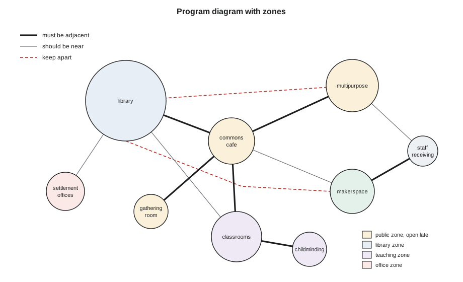
A brief lists spaces. A program diagram shows how they relate: which must be next to which, which must be separated, which open early and close late, which are noisy and which need quiet, which take deliveries and which need daylight. Hartmann asks each student to draw the Commons as bubbles of the right relative size, connected by lines of three weights: must be adjacent, should be near, and must be kept apart. The diagrams differ, but they agree on several things. The entry commons must be the hinge of the building, the first space anyone enters and the one from which every part can be reached. The multipurpose room and the gathering room must be usable in the evening when the library is closed. The makerspace needs a loading door and must be kept away from the quiet study rooms. The childminding room must be next to the classrooms, because parents attending a class need to be a few steps away.
The diagram also reveals a problem of security that the brief does not mention. The building will be open from early morning to late evening, but its parts will open and close at different times. The library opens at ten and closes at eight. Classes run from nine to nine. The settlement agency keeps office hours. The multipurpose room is booked for meetings, weddings and community dinners until eleven at night. The students therefore divide the building into zones that can be locked separately: a public zone that is always open when the building is, a library zone, an office zone and a teaching zone. Each zone must have its own access from the commons and, ideally, its own washrooms. Natarajan says that this kind of zoning is the most common failure she sees in public buildings designed by architects who have never had to run one: the evening program ends up wandering through a dark library to reach the washrooms.
Stacking the program
The site and the diagram together suggest a section. The avenue is the front: the bus stop, the shops and the houses beyond are all to the north, and the zoning requires a street wall with active, transparent frontage there. The park and the creek are the back, and also the view. The ground falls from front to back. Most of the students put the public spaces at the level of the avenue and lift the quieter, more private spaces to an upper floor, and Hartmann thinks this is right for this building. The library's collections, which are heavy, belong on the ground floor where they can sit on a slab supported directly by the ground or by the foundations. The children's library belongs on the ground floor too, close to the entrance and to the park. The multipurpose room needs a tall, wide space without columns and is easiest as a one-storey wing. The classrooms, the childminding room, the settlement offices and the library's study rooms and teen area can share an upper floor.
Callum's stacking puts about 2,100 m² on the ground floor and 1,500 m² on the upper floor. He arranges the ground floor as a long bar along the avenue, with the commons and café at the west end facing the bus stop, the library in the middle, and the makerspace and staff areas at the east end where trucks can reach them from Pell Street. The multipurpose room is a wing at the east end, projecting south toward the park, with its own entrance from the sidewalk for evening events. The gathering room sits at the west end of the park side, a few steps from the creek, with its own door to the park. The upper floor covers the west two thirds of the bar. Above the east end and the makerspace he proposes a saw-toothed roof, a reference to the rail sheds that once stood here, with its glazed faces turned north to bring even daylight into the workshop.
Before going further, Callum checks that his stacking adds up. The script below totals the net area on each floor, compares it with the gross area he has drawn, and computes the efficiency, the ratio of net to gross. It also computes the building's coverage of the site and its floor area ratio, which the zoning framework limits.
# Rail Yard Commons: net and gross areas by floor, coverage and FAR
ground = {"commons and cafe": 260, "library collections and children": 600, "multipurpose": 280,
          "gathering room": 120, "makerspace": 200, "staff and receiving": 160}
upper = {"library study and teens": 300, "media lab": 120, "classrooms": 420,
         "settlement offices": 220, "childminding": 80}
gross = {"ground": 2100, "upper": 1500}           # gross floor areas (m2)
site = 4400                                    # site area (m2)
for name, rooms in (("ground", ground), ("upper", upper)):
    net = sum(rooms.values())
    print(f"{name:<7} net {net:7,.0f} m2   gross {gross[name]:7,.0f} m2   efficiency {net / gross[name]:.2f}")
net_total = sum(ground.values()) + sum(upper.values())
gross_total = sum(gross.values())
print(f"total   net {net_total:7,.0f} m2   gross {gross_total:7,.0f} m2   efficiency {net_total / gross_total:.2f}")
print(f"coverage {gross['ground'] / site:.2f} floor area ratio {gross_total / site:.2f} (framework limit about 2)")ground net 1,620 m2 gross 2,100 m2 efficiency 0.77 upper net 1,140 m2 gross 1,500 m2 efficiency 0.76 total net 2,760 m2 gross 3,600 m2 efficiency 0.77 coverage 0.48 floor area ratio 0.82 (framework limit about 2)
The efficiency of about 0.77 is typical of a public building with generous circulation and a large entry space. Hartmann explains that a value much above 0.8 in a building like this usually means the circulation, the walls, the shafts and the plant rooms have been underestimated; a value much below 0.7 means the building is paying for space that nobody asked for. The floor area ratio of about 0.8 is well below what the framework allows, and Kowalchuk will later ask whether the city could build housing above the building one day. Szymańska will have something to say about that in the structural lesson.
Levels, flood and the ground floor
The level of the ground floor is one of the heavy decisions. It must be at the level of the avenue sidewalk, or within a gentle slope of it, so that the main entrance has no steps; the brief insists on that, and the accessibility lesson will hold the students to it. It must be safely above the park's flood level, which it is, by 1.1 m. And it must meet the park, which lies 1.75 m lower at the edge of the parcel. The question is how. Wren proposes a plinth: a raised terrace along the south side of the building, with broad steps and a long ramp down to the park. Joon-ho proposes the opposite: a lower ground floor on the park side, half buried at the avenue, containing the makerspace and the gathering room. Callum chooses something between them: the building sits at avenue level, the park side has a terrace one step below the floor with seating terraces and a ramped path at a gentle slope down to the park, and the gathering room has a timber deck that steps down toward the creek.
Each choice changes something else. Joon-ho's lower floor would need to be waterproofed against groundwater, would need its own exits to grade on the park side, and in the clay would cost more to excavate. Wren's plinth would be a large area of hard surface that the stormwater study would have to absorb. Callum's terrace keeps the floor simple but makes the park side of the building a long edge that must be designed with as much care as the avenue. Hartmann does not choose between them. She asks each student to draw a section through the whole site, from the houses north of the avenue to the creek, at 1:200, with the flood level, the groundwater level, the depth of firm till, the sun at noon in December and June, and the building in place. 'If the section works,' she says, 'the plan will follow. If it does not, no plan will save it.'
Climate, snow and orientation
The long side of a building in this climate should usually face south, to collect low winter sun and to make summer shading easy with overhangs. The parcel obliges: the avenue is on the north and the park on the south. The north façade, facing the street, will be the public front but will receive little sun; the south façade, facing the park, will receive a great deal. This reverses the usual relation between a public building's best face and its best light, and the students discuss what to do about it. Ingrid suggests that the north front should be glazed for transparency at street level only, with high windows above to bring in the even north light that suits a library, while the south side carries the big views and the shading. Callum's saw-toothed roof is another answer: north-facing glass at roof level gives daylight without glare deep into the plan.
Snow and wind matter as much as sun. The north-west wind that Wren felt on the sidewalk will scour snow from the avenue side and drop it in the lee of the building, on the park side, where the terrace and the ramps are. Entrances on the north should be recessed or sheltered by a canopy, so that the doors are not held open by a gale. Snow from the roof must not fall on people at the doors, so the roof should drain inward or the eaves must be well away from the entrances. Snow cleared from the sidewalk and the drop-off needs somewhere to go that does not block the accessible route. These are small things on a drawing and large things in February.
Worked problem
Checking the program against the site
Callum's first plan places the loading dock on the avenue, at the east end of the bar, because the makerspace is there and the avenue is wider than Pell Street. Kowalchuk, visiting the studio, objects. How should Callum test the location, and what should he do?
Show solution
- List the requirements: a truck of about 10 m must reach the dock, turn and leave; deliveries come a few times a week; the makerspace takes materials in and waste out.
- Check the zoning framework: the avenue frontage must be active and transparent for at least 60% of its length, with no blank wall longer than 6 m and an entrance every 15 m.
- Check movement: a truck backing across the avenue sidewalk crosses the bike lane and the main pedestrian route from the bus stop.
- Check Pell Street: it is quieter, the dock can be set back with a turning area on the site, and a screen wall can hide it from the houses opposite.
- Move the dock to Pell Street and put the makerspace's display window on the avenue instead.
Answer: The dock moves to Pell Street, and the avenue frontage gains a workshop window where people walking past can watch things being made.
Exercise 2: program and site
- Complete the site analysis checklist for the Commons and draw the site section from the houses to the creek.
- Draw a program diagram with sized bubbles, adjacencies, separations and opening-hours zones.
- Stack the program on one or more floors and check net and gross areas, efficiency, coverage and floor area ratio with the script.
- Choose the ground floor level and show on the section how the building meets the avenue and the park.
Self-check
- Can the evening program be used without opening the library?
- Is the main entrance visible from the bus stop and reachable without steps?
- Is your building efficiency between about 0.7 and 0.8, and if not, why not?
Common mistakes
MistakeAnalysing the site at the scale of the district again instead of the scale of the building.
InsteadGather the facts the building needs: levels, ground, services, climate, movement and neighbours.
MistakeIgnoring the flood level and the groundwater until the structure is designed.
InsteadSet the ground floor level against both in the first week.
MistakeDrawing a program diagram without opening hours.
InsteadZone the building by when each part is used, so parts can be locked separately.
MistakeAssuming an efficiency of 0.9 to make the program fit.
InsteadUse about 0.75 for a public building and adjust as the plans develop.
MistakePutting the loading dock where the street is widest.
InsteadPut service where it does least harm to the public frontage and the pedestrian routes.
Summary and key terms
- A building's site analysis gathers the facts that decide where it sits, how high its floor is, where its doors are and what its walls must do.
- A program diagram shows adjacencies, separations, noise, deliveries, daylight and opening hours, not just areas.
- Zoning a public building by opening hours lets parts be locked while others stay open.
- Callum's Commons has about 2,100 m² on the ground floor and 1,500 m² above, with an efficiency of about 0.77.
- The ground floor level must meet the avenue without steps, stay above the flood level and meet the lower park gracefully.
- Program diagram
- A drawing of a building's spaces as sized shapes, showing how they relate.
- Efficiency
- The ratio of net assignable area to gross floor area.
- Design flood level
- The water level used to design against flooding, often the level of a flood with a one-in-a-hundred chance each year.
- Coverage
- The share of a site covered by buildings.
- Floor area ratio
- The gross floor area of a building divided by the area of its site.
Practice problems
Work each problem on paper first, then reveal the answer to check.
A building has 2,760 m² of net area and 3,600 m² of gross area. What is its efficiency?
Show answer
2,760 ÷ 3,600 ≈ 0.77.
The same building stands on a site of 4,400 m². What is its floor area ratio?
Show answer
3,600 ÷ 4,400 ≈ 0.82.
The ground floor is 1.1 m above the design flood level and the rule requires 0.6 m. How much lower could part of the floor go?
Show answer
0.5 m.
Why should the library collections be on the ground floor?
Show answer
They are heavy, and on the ground floor they can be supported directly by the ground or the foundations.
A truck dock on the avenue would leave a blank wall 9 m long. Does it meet the framework?
Show answer
No: blank walls facing a street may be no longer than 6 m.
Name two items of a site analysis that come from documents rather than a visit.
Show answer
The survey of levels and the geotechnical report; also the stormwater study and service drawings.
Lesson quiz · 5 questions
Score 60% or more to complete this lesson.
Create a free account to save your progress, take quizzes and earn a certificate.