
ARCH-201 · Lesson 3 of 12 · 21 min
Housing density
The word density causes more arguments at public meetings than any other word in planning, Castellanos warns. To some residents it means traffic, shadows and strangers. To others it means a corner store that can survive, a bus that comes every ten minutes and a school that does not close. Before the students draw a single building for the lumber yard site, she asks them to measure density in the neighbourhood around it. Joon-ho and Wren count the homes on the block of small houses west of the site: forty-two houses, of which eleven have been divided into two or three apartments, on a block of about 1.6 hectares. Ingrid and Callum count the four-storey apartment building on the avenue near the school, built in the 1960s: sixty units on a lot of about 0.4 hectares. 'The apartment building has about four times the density of the houses,' Ingrid says, 'and nobody at the community meeting even mentioned it. They mentioned the empty lumber yard.'
What density measures
Density describes how much is built, or how many people or homes there are, on a given area of land. There are several measures, and they do not always agree. Architects and planners must be clear about which one they mean.
- Floor area ratio (FAR): total gross floor area divided by the lot area. It measures the bulk of building and is the measure most zoning codes use.
- Site coverage: the building footprint divided by the lot area. It measures how much of the ground is built over.
- Dwelling density: the number of homes per hectare. It measures housing supply and is used for transit and service planning.
- Population density: the number of people per hectare. It depends on household size as well as the number of homes.
- Net and gross density: net density counts only the lots on which homes stand; gross density includes streets, parks and other land in the area.
The same building can look dense by one measure and sparse by another. A tower of small studios has a high dwelling density but a low population per home. A row of large family townhouses may have a modest FAR but a high population density. The measures also depend on the boundary used: a building on a small lot with a park next door has high net density but a lower gross density.
Comparing three schemes on the site
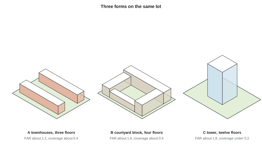
The students test three very different ways of building on the lumber yard lot, which measures 60 by 45 m, an area of 2,700 m². Scheme A is a group of twenty three-storey townhouses arranged in two rows around a shared lane. Scheme B is a four-storey courtyard block of about fifty apartments around a central garden. Scheme C is a twelve-storey point tower of about sixty apartments in a landscaped open space.
# Three ways to build on the same lot: floor area ratio, coverage and density
lot = 2700                        # lot area (m2)
per_area = 0.27                   # lot area in hectares
schemes = {
    #  name                      footprint  gross  homes  people per home
    "A townhouses (3 floors)":  (1100,      3300,   20,    3.2),
    "B courtyard (4 floors)":   (1150,      4400,   50,    2.3),
    "C tower (12 floors)":      (450,      5000,   60,    1.7),
}
for name, (foot, gross, homes, pph) in schemes.items():
    people = homes * pph
    open_ground = lot - foot
    print(name)
    print(f"   FAR {gross / lot:.2f}, coverage {foot / lot:.2f}")
    print(f"   {homes / per_area:.0f} homes and {people / per_area:.0f} people per hectare")
print(f" open ground {open_ground:,.0f} m2 = {open_ground / people:.1f} m2 per person")A townhouses (3 floors) FAR 1.22, coverage 0.41 74 homes and 237 people per hectare open ground 1,600 m2 = 25.0 m2 per person B courtyard (4 floors) FAR 1.63, coverage 0.43 185 homes and 426 people per hectare open ground 1,550 m2 = 13.5 m2 per person C tower (12 floors) FAR 1.85, coverage 0.17 222 homes and 378 people per hectare open ground 2,250 m2 = 22.1 m2 per person
The results surprise the students. The tower has the highest FAR and the most homes, but because its homes are small and its households are smaller, it houses fewer people than the courtyard block: about 102 people against 115. The townhouses have the lowest FAR and only twenty homes, but every home is a family home, so they house about 64 people, more than half the tower's population in a third as many homes. The tower also leaves by far the most open ground, almost all of it a shaded, windswept lawn around its base. The courtyard block leaves the least open ground per person, but concentrates it in one sheltered garden that residents can see from their kitchens, while the townhouses divide theirs into small private yards and a shared lane.
Perceived density
People do not experience density as a number. They experience height, bulk, shadow, the closeness of windows across the street, traffic, crowding on sidewalks and the quality of public space. Studies of perceived density have repeatedly found that people judge low-rise buildings with good streets and gardens to be less dense than towers of the same or lower actual density, and that well-designed, well-kept higher-density neighbourhoods are judged more pleasant than poorly designed lower-density ones.
Several design factors make density feel comfortable. Buildings that line the street with entrances, windows and small front gardens make the street feel safe and lively. Heights that relate to the width of the street avoid canyon effects. Courtyards and gardens that residents can use and control feel larger than open lawns that belong to nobody. Variety in the facades and roofline breaks up large buildings. Trees soften everything. Many of the most loved neighbourhoods in North America and Europe, such as the row-house streets of Montreal's Plateau, the brownstones of Brooklyn or the courtyard blocks of Paris and Barcelona, have densities far higher than most new suburbs and many recent tower districts.
Why density matters
Density matters for reasons beyond the individual building. A neighbourhood needs a certain number of residents within walking distance to support frequent public transit, a grocery store, a school and a library branch. Transit planners commonly say that frequent bus service needs at least several tens of homes per hectare within a few minutes' walk of the stops. Low densities also cost more to serve per household, because every home needs its share of roads, pipes and snow clearing.
Density affects the environment too. Homes in multi-unit buildings use less energy per household than detached houses, because they share walls and have less exposed surface. Residents of denser neighbourhoods drive less, because more destinations are within walking or cycling distance and transit is better. Adding homes on existing serviced land, such as the lumber yard site, avoids building on farmland at the edge of the city.
On the other hand, density without design produces real problems: overlooking and loss of privacy, noise between homes, shadowed streets and gardens, and pressure on schools and parks that were planned for fewer people. The task is not to maximize density, nor to minimize it, but to find the density at which a place works well, and then to design it so it feels right.
Daylight and spacing between buildings
As buildings become taller and closer together, they shade each other and the ground between them. A useful way of controlling this is to keep a minimum angle of sky visible from the lower windows of each building. Many design guides suggest that, for good daylight on lower floors, the obstruction from a building opposite should rise no higher than about 25 to 30 degrees above the horizontal, measured from the middle of a ground-floor window. At a latitude of about 50 degrees north, the winter sun is even lower: at noon on the shortest day, it is less than 17 degrees above the horizon, so almost any building casts a shadow more than three times its height.
For housing, the practical consequences are clear. Facing windows across a courtyard need generous spacing, often at least the height of the buildings and preferably more. Courtyards in cold northern cities should open to the south or be lower on the south side, so that sun reaches the ground for at least part of the day in spring and autumn. Taller elements should be placed on the north side of the site, where their shadows fall on streets, parking or the greenway rather than on gardens and other homes.
Density in the brief
Greenway Homes' brief asks for about fifty homes on a 0.27-hectare site. That is a dwelling density of about 185 homes per hectare, higher than the block of houses to the west but lower than the tower scheme. The zoning on the site, which the city amended when Greenway Homes bought the land, allows buildings of up to four storeys and 15 m, limits coverage to 60 out of every 100 units of lot area and sets a maximum FAR of 2.0. Within 10 m of the houses to the west, buildings may rise to only three storeys. Setbacks are 3 m from the greenway, Marlow Street and Aldous Street, and 4.5 m from the west lot line. There is no minimum parking requirement, because the site is within a short walk of frequent bus service on the avenue.
Worked problem
Choosing a density for the site
The students must recommend a range of density for the brief. The block to the west, counting the apartments in the divided houses, has about 36 homes per hectare. The neighbourhood association has said that it will support 'a building that fits'. Greenway Homes wants about fifty homes. What range should the students recommend, and why?
Show solution
- Fifty homes on the site is about 185 homes per hectare, roughly five times the density of the block to the west. In numbers alone, that sounds alarming.
- But the 1960s apartment building near the school, at about 150 homes per hectare, shows that density at this level already exists in the neighbourhood without complaint, because it is four storeys and lines the street.
- Scheme B, the courtyard block, reaches the brief at four storeys with a FAR of about 1.6 and coverage of just over 0.4, within the zoning and with a usable courtyard.
- A building of three storeys next to the houses, rising to four along Marlow Street and the greenway, would step down to the existing homes while keeping the density the brief needs.
- The students recommend 45 to 55 homes, at a FAR between 1.5 and 1.8, in a building of three and four storeys.
Answer: A density of about fifty homes is appropriate, provided the design steps down to the houses, lines the streets and keeps a sunny courtyard. Density is acceptable when its form fits.
Exercise 3: density studies
This exercise takes about one week and is done in pairs.
- Measure the density of three existing housing types in the neighbourhood by every measure in this lesson: FAR, coverage, homes per hectare and people per hectare.
- Photograph each type from the street and record how dense it feels, independently of the numbers.
- Build three quick massing models of the lumber yard site at 1:500 at a FAR of about 1.6, using three different forms.
- For each model, calculate the measures and test the winter shadows with a sun lamp or a digital model.
- Present a recommendation for the density and form of the project, with the evidence.
Self-critique checklist
- Have I been clear about which density measure I am using?
- Have I compared people as well as homes and floor area?
- Have I tested what each scheme does to sun, privacy and the street?
- Can I explain my recommendation to a neighbour who fears density?
- Does my recommendation fit the zoning and the brief?
Density over the life of a building
Density is not fixed when a building opens. The number of people living in it changes as households form, grow and shrink. A building of family homes may house many children in its first fifteen years and far fewer in its fortieth, when the parents remain and the children have left. A building of small units may house mostly young single people at first and later older residents who stay for decades. Over the life of a neighbourhood, this changing population is why schools fill and empty and why corner stores open and close.
Housing providers therefore look at density over decades, not only on opening day. A mix of unit sizes keeps a building's population more stable, because different households arrive and leave at different stages of life. Homes that can adapt, for example two-bedroom units whose second bedroom can become an office, a room for a carer or a nursery, let residents stay as their needs change instead of moving away. Castellanos tells the students that the density figure on their drawings is a snapshot. 'Design for the film,' she says, 'not the photograph.'
Common mistakes
MistakeUsing one density measure as if it told the whole story.
InsteadCompare FAR, coverage, homes and people per area together.
MistakeEquating density with height.
InsteadLow-rise courtyard blocks and row houses can be as dense as towers.
MistakeTreating leftover open ground as useful open space.
InsteadAsk who uses and controls the open space, and whether it gets sun.
MistakePlacing tall elements where their shadows fall on gardens.
InsteadPut the tallest parts on the north side of the site.
MistakeArguing for density only with numbers.
InsteadShow what it will look and feel like from the street and the gardens.
Summary and key terms
- Density can be measured as floor area ratio, coverage, homes per area or people per area, net or gross.
- The same density can take very different forms; perimeter blocks reach high densities at moderate heights.
- People judge density by height, bulk, shadow and the quality of streets and open space, not by numbers.
- Enough density supports transit, shops and schools and reduces energy use and driving.
- At northern latitudes, low winter sun makes spacing and the placement of taller elements critical.
- Dwelling density
- The number of homes per unit of land area.
- Population density
- The number of people per unit of land area.
- Net density
- Density measured on the residential lots only.
- Gross density
- Density measured over a whole area, including streets and parks.
- Perceived density
- How dense a place feels to the people who use it.
- Perimeter block
- A block whose buildings line its edges, enclosing a courtyard.
Practice problems
Work each problem on paper first, then reveal the answer to check.
A lot of 2,000 m² holds a building with a footprint of 800 m² and four storeys. What are its coverage and FAR?
Show answer
Coverage 0.40; FAR 1.60.
Forty homes stand on 0.5 hectares. What is the dwelling density?
Show answer
80 homes per hectare.
Why might a tower house fewer people than a courtyard block with fewer homes?
Show answer
Its homes may be smaller, with fewer people per home.
Why should a courtyard in a northern city open to the south?
Show answer
The low winter sun can then reach into the courtyard over the lower south side.
Give two ways to make a dense building feel less dense from the street.
Show answer
Line the street with entrances and front gardens, and break the facade and roofline into smaller parts; trees also help.
Lesson quiz · 5 questions
Score 60% or more to complete this lesson.
Create a free account to save your progress, take quizzes and earn a certificate.