
ROB-340 · Lesson 2 of 12 · 30 min
Map representations
A map is a model of the environment that a robot can use to localize itself, plan paths and reason about what it will meet. There is no single best map. A floor-cleaning robot, a warehouse robot, an underwater vehicle and a self-driving car need very different maps, because they use them for different purposes and have different sensors, memory and computing budgets. Choosing the representation is one of the first and most consequential design decisions in a mobile robot system, because it determines which localization and SLAM algorithms are possible, how much memory the map takes, how well it handles change, and how easy it is for people to inspect and edit. This lesson surveys the main families: metric grids, point clouds, voxel and octree maps, signed distance fields, feature (landmark) maps, topological maps and semantic maps.
What a map must do
Before choosing a representation, list what the map is for. For localization, the map must let the robot predict what its sensors should see from any candidate pose, so that measurements can be scored. For path planning, it must say which places are free, which are occupied and which are unknown. For human interaction, it should carry labels people understand, such as 'loading dock 3' or 'kitchen'. For long-term operation, it must be updatable as furniture moves, pallets come and go, and doors open and close. A good map is also compact enough to store and share, and its accuracy should match the task: a warehouse robot needs centimeters, a delivery drone meters.
| Representation | Stores | Good for | Limitations |
|---|---|---|---|
| Occupancy grid | Probability that each cell is occupied | Lidar localization, 2-D planning | Memory grows with area; 2-D only (unless 3-D) |
| Point cloud | Raw 3-D points | Scan matching, inspection | No free-space information; large |
| Voxel grid / octree | Occupancy in 3-D cells | 3-D planning for drones and arms | Memory; resolution trade-offs |
| Signed distance field | Distance to the nearest surface | Smooth surfaces, collision checks | Computation; mostly near surfaces |
| Feature map | Landmark positions with uncertainty | EKF-SLAM, visual SLAM | Discards most data; needs reliable features |
| Topological map | Places and connections | Large-scale routing, human directions | No precise geometry |
| Semantic map | Labels for objects and areas | Task-level reasoning | Needs perception; labels can be wrong |
Occupancy grids
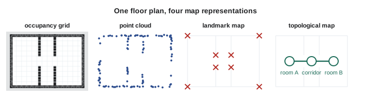
An occupancy grid divides the plane into square cells of fixed size, typically 2 to 10 cm, and stores for each cell the probability that it is occupied. Unknown cells start at 0.5. As the robot moves, each laser beam lowers the probability of the cells it passes through and raises the probability of the cell where it ends. Hans Moravec and Alberto Elfes introduced the idea in the mid-1980s, and it remains the most widely used map in indoor robotics: ROS map_server stores grids as a PGM image plus a YAML file giving the resolution, origin and thresholds, and the Nav2 navigation stack plans on them. Lesson 4 derives the update in detail.
Grids are simple, handle arbitrary shapes, distinguish free space from unknown space, and give constant-time lookup. Their weakness is memory: a 2-D grid's size grows with the area covered divided by the square of the resolution, whether or not anything interesting is there, and a 3-D grid grows with the cube.
Worked problem
Memory for a warehouse grid
A warehouse is 200 m by 120 m. How many cells does a 5 cm occupancy grid need, and how much memory at one byte per cell? What if the resolution is halved to 2.5 cm?
Show solution
- Cells: \( (200/0.05) \times (120/0.05) = 4000 \times 2400 = 9.6 \) million.
- At one byte each: 9.6 MB.
- At 2.5 cm: four times as many cells, 38.4 million, about 38 MB.
Answer: About 10 MB at 5 cm and 38 MB at 2.5 cm. A 2-D grid of a large building is easily manageable on a robot computer; halving the resolution quadruples the memory.
Point clouds
A point cloud is simply a set of 3-D points, usually from a lidar or depth camera, registered into a common frame. It preserves fine geometry and is the natural input to scan matching (lesson 9) and to inspection and surveying, where the cloud itself is the product. But a point cloud says nothing about free space: the absence of points in a region could mean it is empty, or simply that the sensor never looked there. Clouds are also large, millions of points for a single building floor, and are usually downsampled with a voxel filter (keeping one point per cube of a chosen size) before use, as in ROB-330 lesson 8. Many lidar SLAM systems keep their map as a set of keyframe clouds or a downsampled global cloud, and localize new scans against it with ICP or NDT.
Voxel grids and octrees
For robots that move in 3-D, such as drones, or manipulators that reach into shelves, a 2-D grid is not enough. A voxel grid extends the occupancy grid to 3-D cubes, but memory grows with the cube of the resolution. Octrees solve this by subdividing space only where needed: each node covers a cube, and only cubes that contain something are split into eight children. Large empty or uniformly occupied regions stay as single big nodes. OctoMap (Hornung and colleagues, 2013) is the standard probabilistic octree for robotics: it stores log-odds occupancy in each leaf, distinguishes free, occupied and unknown space, supports multi-resolution queries, and is widely used with ROS for 3-D collision checking and exploration.
Worked problem
Why an octree saves memory
A 3-D map covers a 64 m cube at 5 cm resolution. How many voxels does a dense grid need? If only about 2 % of the volume is near observed surfaces and the rest is large free or unknown blocks, roughly how much does an octree need?
Show solution
- Dense voxels: \( (64/0.05)^3 = 1280^3 \approx 2.1 \times 10^9 \).
- At one byte each: about 2.1 GB.
- With roughly 2 % needing full resolution, about \( 4.2 \times 10^7 \) leaves, plus internal nodes and per-node overhead (often 10 to 20 bytes).
- Order of magnitude: several hundred megabytes, and much less if free space is pruned into large nodes.
Answer: Over 2 GB dense versus a few hundred MB as an octree. The exact saving depends on how cluttered the environment is, but octrees routinely cut 3-D map memory by an order of magnitude.
Signed distance fields
A signed distance field (SDF) stores, in each voxel, the distance to the nearest surface: positive in free space, negative inside objects and zero exactly on the surface. Truncated SDFs (TSDFs) store the distance only near surfaces and are the representation behind KinectFusion (Newcombe and colleagues, 2011), which fused depth camera frames into smooth, accurate surfaces in real time. Euclidean signed distance fields (ESDFs) store the distance everywhere and are prized by planners, because the distance to the nearest obstacle, and its gradient, come straight from a lookup, which is exactly what a trajectory optimizer needs to push a path away from obstacles. Voxblox (2017) and its successors build ESDFs incrementally for drones and mobile manipulators.
Feature maps
A feature map, or landmark map, keeps only a list of distinctive landmarks with their estimated positions and uncertainties: corners and poles detected in laser scans, visual keypoints with descriptors, fiducial markers, or reflectors on a wall. It throws away most of the sensor data, which makes it compact and lets the estimator track the correlations between landmarks explicitly. EKF-SLAM (lesson 6) and FastSLAM (lesson 7) were built on feature maps, and visual SLAM systems such as ORB-SLAM (lesson 10) keep a map of 3-D keypoints. The cost is that the robot depends on detecting and recognizing the same landmarks reliably, which requires the environment to have enough of them and the data association to be right.
Topological and hybrid maps
A topological map is a graph: nodes are distinctive places (rooms, junctions, doors, docking stations) and edges are routes between them, labeled with how to travel. It captures the structure people use when giving directions (go down the corridor, turn left at the lift) and scales to very large areas, because its size grows with the number of places, not with the area. It cannot by itself support precise obstacle avoidance. Many systems are therefore hybrid: a topological graph for long-range routing whose nodes each hold a small local metric map. Multi-floor buildings are naturally hybrid, with one grid per floor connected through lift and stair nodes.
Semantic maps
A semantic map adds meaning: object classes and instances (chairs, shelves, pallets, people), area labels (aisle 12, kitchen, charging zone) and relations (the mug is on the table). Semantic labels come from the learned perception of ROB-330 lessons 9 and 10, projected into the map. They let a robot accept commands such as 'fetch the red bin from shelf B4', reason about which objects are likely to move, and ignore dynamic objects when localizing. Open-vocabulary 3-D scene graphs built with vision-language models were a fast-moving research area at the time of writing. Semantic maps inherit the errors of perception, so production systems usually keep a reliable geometric map underneath and treat semantics as an annotation layer that can be corrected.
import numpy as np
# Compare memory for three representations of the same 40 m x 30 m floor
W, H, res = 40.0, 30.0, 0.05
cells = int(W / res) * int(H / res)
grid_bytes = cells * 1                        # one byte per occupancy cell
wall_len = 2 * (W + H) + 6 * 20.0             # outer walls plus six 20 m racks
pts = int(wall_len / 0.01) * 16               # 1 cm spacing, 16 lidar rings hitting walls
cloud_bytes = pts * 3 * 4                     # x, y, z as 32-bit floats
landmarks = 400                               # corners, pillars, reflectors
lm_bytes = landmarks * (2 * 8 + 3 * 8)        # 2-D position + 2x2 covariance (3 unique)
for name, b in [("occupancy grid", grid_bytes), ("raw point cloud", cloud_bytes),
                ("landmark map", lm_bytes)]:
print("%-16s %10.2f MB" % (name, b / 1e6))occupancy grid 0.48 MB raw point cloud 4.99 MB landmark map 0.02 MB
Choosing a representation
In practice the choice follows from the sensors, the task and the scale. A 2-D lidar indoors points to an occupancy grid for both localization and planning, which is why that combination is the default in ROS 2 Nav2. A 3-D lidar outdoors often means a point-cloud or voxel map for localization plus a 2-D or 2.5-D cost map (an elevation map storing the height of the ground in each cell) for driving. A camera-only robot naturally builds a feature map for localization and may add a depth-based grid for obstacles. A drone in a cluttered building needs a 3-D occupancy or distance field. Very large areas call for hybrid topological-metric maps, or for splitting the map into tiles or submaps that are loaded as the robot moves. Most real systems keep several layers, built from the same SLAM output, each serving a different consumer.
Worked problem
Choosing a map for a hospital delivery robot
A delivery robot carries medicines between a pharmacy and wards across four floors of a hospital, using a 2-D lidar, a depth camera and the lifts. Staff need to mark no-go zones. What map layers would you choose?
Show solution
- Per floor: a 5 cm occupancy grid from 2-D lidar SLAM for localization and planning.
- A depth-camera obstacle layer added at run time for tables, beds and overhanging objects the 2-D lidar misses.
- A topological layer connecting floors through lift nodes, with routes between named places (pharmacy, ward 4B).
- A semantic annotation layer for named destinations and staff-drawn keep-out zones.
Answer: A hybrid map: metric grids per floor for precise navigation, a topological graph for multi-floor routing, and annotation layers that people can edit without re-running SLAM.
Common mistakes
MistakeTreating the absence of points in a point cloud as free space
InsteadUse a representation that records free space explicitly, such as an occupancy grid or octree.
MistakeChoosing a very fine grid resolution everywhere
InsteadMatch resolution to the task and sensor accuracy; memory grows with the square or cube of resolution.
MistakeBuilding only a feature map and then trying to plan collision-free paths on it
InsteadKeep a separate occupancy or distance layer for planning.
MistakeStoring semantic labels as if they were certain
InsteadKeep a geometric map underneath and let semantic labels be corrected.
MistakeUsing one huge global grid for a multi-floor building
InsteadUse one map per floor linked through a topological layer.
Summary and key terms
- The right map depends on its uses: localization, planning, human interaction and long-term updating.
- Occupancy grids store occupancy probability per cell and are the standard for 2-D lidar navigation.
- Point clouds keep raw geometry but say nothing about free space; they are usually downsampled.
- Octrees such as OctoMap give memory-efficient 3-D occupancy; signed distance fields give distance to the nearest surface.
- Feature maps keep only landmarks with uncertainties and underpin EKF-SLAM and visual SLAM.
- Topological maps capture places and routes and scale to very large areas, usually in hybrid with metric maps.
- Semantic maps add object and area labels from perception, layered over a reliable geometric map.
- Occupancy grid
- A grid map storing the probability that each cell is occupied.
- Resolution
- The side length of a map cell or voxel.
- Point cloud
- A set of 3-D points measured by a range sensor.
- Voxel
- A cubic cell of a 3-D grid.
- Octree
- A tree that recursively divides space into eight cubes only where needed.
- OctoMap
- A widely used probabilistic octree map for robotics.
- Signed distance field
- A map storing the signed distance to the nearest surface.
- Feature map
- A map made of distinctive landmarks with estimated positions.
- Topological map
- A graph of places connected by traversable routes.
- Semantic map
- A map annotated with object and area labels.
Practice problems
Work each problem on paper first, then reveal the answer to check.
What value does an unknown cell usually hold in an occupancy grid?
Show answer
0.5 probability.
How does memory change if a 2-D grid's resolution is halved?
Show answer
It grows four times.
How does memory change if a 3-D grid's resolution is halved?
Show answer
It grows eight times.
Why can't a raw point cloud alone be used to plan through unknown space?
Show answer
It does not distinguish free space from unobserved space.
What does an octree avoid storing?
Show answer
Fine cells in large uniform regions, such as empty space.
Name a famous system that fused depth images into a TSDF.
Show answer
KinectFusion.
Why do planners like Euclidean signed distance fields?
Show answer
They give the distance to the nearest obstacle and its gradient directly.
Name two kinds of landmark in a feature map.
Show answer
Laser-scan corners or poles, visual keypoints, fiducial markers or reflectors.
What do the nodes and edges of a topological map represent?
Show answer
Places and routes between them.
Why keep a geometric map under a semantic map?
Show answer
Semantic labels come from perception and can be wrong; geometry stays reliable.
Lesson quiz · 5 questions
Score 60% or more to complete this lesson.
Create a free account to save your progress, take quizzes and earn a certificate.