
PHYS-481 · Lesson 3 of 12 · 25 min
Thermodynamics of the atmosphere: adiabats, stability and clouds
On a summer afternoon over the Prairies, the morning sky is clear, flat-bottomed cumulus clouds appear by noon, and by late afternoon some of them have grown into towering thunderstorms with tops near 12 km. The flat bases all sit at the same height, and the storms grow only on some days and not others. Both observations are explained by the thermodynamics of a parcel of air that rises without exchanging heat with its surroundings. This lesson derives the dry and moist adiabatic lapse rates, uses them to find the cloud-base height, introduces potential temperature as the conserved quantity of dry adiabatic motion, and shows how comparing a rising parcel with its environment decides whether the atmosphere is stable, unstable or conditionally unstable. It ends with the buoyancy frequency, the natural oscillation frequency of a stable atmosphere, and with convective available potential energy, the fuel of thunderstorms.
The parcel model
Meteorologists reason with an idealized parcel of air: a blob large enough to contain many molecules but small enough that its pressure always matches the surroundings at its current height. Because air is a poor conductor of heat and mixes slowly with its surroundings over the minutes a parcel takes to rise a kilometer, its expansion is very nearly adiabatic. As the parcel rises into lower pressure it expands and does work on its surroundings, and with no heat flowing in, that work comes from its internal energy, so it cools. The first law of thermodynamics per unit mass, for a reversible change with heat input \(dq\), is
where \(c_p \approx 1004\) J kg\(^{-1}\) K\(^{-1}\) is the specific heat of dry air at constant pressure. Setting \(dq = 0\) and using hydrostatic balance for the surroundings, \(dp = -\rho g\,dz\), and the fact that the parcel's pressure matches the environment's, gives
This is the dry adiabatic lapse rate. It is a property of the parcel, not of the atmosphere around it. A parcel of dry air rising 1 km cools by 9.8 K, and sinking 1 km warms it by the same amount. Downslope winds such as the chinook east of the Rocky Mountains are an everyday example: air that descends 2 km on the lee side warms by about 20 K, enough to melt snow in hours on the Alberta and Montana plains.
Potential temperature
Integrating the dry adiabatic first law, \(c_p\,dT/T = R_d\,dp/p\), between a parcel's state and a reference pressure \(p_0 = 1000\) hPa defines the potential temperature
It is the temperature a parcel would have if brought adiabatically to 1000 hPa, and it is conserved in any dry adiabatic motion. Potential temperature is therefore a label that a parcel carries with it. It also measures the parcel's entropy, since \(s = c_p\ln\theta + \text{constant}\). In a stable atmosphere \(\theta\) increases with height; air from a low level that is lifted arrives colder, in the sense of lower \(\theta\), than the air around it and sinks back. In the stratosphere, where \(\theta\) increases very rapidly with height, surfaces of constant \(\theta\) are almost horizontal sheets along which air moves easily but across which it hardly moves at all.
Moist air and the moist adiabatic lapse rate
Water vapor changes the picture because it can condense. The saturation vapor pressure \(e_s(T)\), the partial pressure of water vapor in equilibrium with liquid water, rises steeply with temperature, as the Clausius–Clapeyron equation \(de_s/dT = L e_s/(R_v T^2)\) requires, with latent heat \(L \approx 2.5\times10^6\) J/kg and \(R_v = 461.5\) J kg\(^{-1}\) K\(^{-1}\). It roughly doubles for every 10 K of warming, about 7 % per kelvin near room temperature. A useful empirical fit, accurate to about 0.1 % between \(-30\) and 35 °C, is Bolton's formula \(e_s = 611.2\exp\big(17.67\,t/(t + 243.5)\big)\) Pa with \(t\) in degrees Celsius. The water content of air is usually described by the mixing ratio \(r\), the mass of vapor per mass of dry air, approximately \(r = \varepsilon e/(p - e)\) with \(\varepsilon = R_d/R_v \approx 0.622\), or by the dew point, the temperature to which the air must be cooled at constant pressure to become saturated.
An unsaturated parcel keeps its mixing ratio as it rises and cools at the dry rate. Its saturation mixing ratio falls with temperature, so at some height it becomes saturated: this is the lifting condensation level, where cloud forms. Above it, further cooling condenses vapor into droplets, releasing latent heat \(L\,dr_s\) that partly offsets the expansion cooling. The first law becomes \(c_p\,dT + g\,dz + L\,dr_s = 0\), and working out \(dr_s\) gives the moist, or saturated, adiabatic lapse rate
In warm, humid air near the surface, where \(r_s\) is large, \(\Gamma_m\) is about 3.5 to 4 K/km; in the cold upper troposphere, where there is little vapor left to condense, it approaches the dry rate.
Cloud base and stability, computed
The program below computes the dry and moist lapse rates, finds the lifting condensation level of a summer parcel both by the 125 m per degree rule of thumb and by stepping the parcel upward, tests the stability of three environmental lapse rates through the buoyancy frequency, and integrates the buoyancy of a parcel lifted through an idealized sounding to find its convective available potential energy.
import math
g = 9.81; cp = 1004.0; Rd = 287.0; Rv = 461.5; L = 2.5e6; eps = Rd / Rv
print(f"dry adiabatic lapse rate g/cp = {g / cp * 1000:.2f} K/km")

def es(T):
    """Saturation vapor pressure in Pa (Bolton 1980), T in kelvin."""
    t = T - 273.15
    return 611.2 * math.exp(17.67 * t / (t + 243.5))

def moist_lapse(T, p):
    rs = eps * es(T) / (p - es(T))
    num = 1 + L * rs / (Rd * T)
    den = 1 + L * L * rs * eps / (cp * Rd * T * T)
    return g / cp * num / den * 1000

for t, p in [(30, 1000e2), (20, 1000e2), (0, 700e2), (-20, 500e2), (-40, 300e2)]:
    print(f"moist lapse rate at {t:4d} C, {p / 100:.0f} hPa: {moist_lapse(t + 273.15, p):.2f} K/km")

# Lifting condensation level for a summer afternoon parcel
T, Td = 30.0, 18.0
print(f"Espy rule LCL = 125 m per degree of dew-point depression = {125 * (T - Td):.0f} m")
# exact: lift dry parcel, conserve mixing ratio, find where it saturates
p_s = 970e2; r = eps * es(Td + 273.15) / (p_s - es(Td + 273.15))
z, Tp, p = 0.0, T + 273.15, p_s
while True:
    rs = eps * es(Tp) / (p - es(Tp))
    if rs <= r: break
    dz = 1.0; Tp -= g / cp * dz
    p *= math.exp(-g * dz / (Rd * Tp)); z += dz
print(f"stepwise LCL: {z:.0f} m above the ground, parcel at {Tp - 273.15:.1f} C, {p / 100:.0f} hPa")

# Stability of the standard troposphere (lapse 6.5 K/km) and buoyancy frequency
T0 = 288.15
for gamma in (6.5, 9.8, 12.0):
    N2 = g / T0 * (g / cp - gamma / 1000)
    if N2 > 0:
        N = math.sqrt(N2)
        print(f"lapse {gamma} K/km: stable, N = {N:.4f} 1/s, period {2 * math.pi / N / 60:.1f} min")
    else:
        print(f"lapse {gamma} K/km: N^2 = {N2:.2e}, unstable for dry parcels")

# Convective available potential energy from a simple sounding
# environment: 6.5 K/km from 30 C; parcel: dry to LCL, then moist
env = lambda zz: 303.15 - 0.0065 * zz
zz, Tpar, pp, cape = 0.0, 303.15, 970e2, 0.0
dz = 10.0
while zz < 12000:
    lapse = g / cp if zz < z else moist_lapse(Tpar, pp) / 1000
    Tpar -= lapse * dz; pp *= math.exp(-g * dz / (Rd * env(zz))); zz += dz
    b = g * (Tpar - env(zz)) / env(zz)
    if b > 0: cape += b * dz
print(f"CAPE of this idealized sounding = {cape:.0f} J/kg, maximum updraft sqrt(2 CAPE) = {math.sqrt(2 * cape):.0f} m/s")dry adiabatic lapse rate g/cp = 9.77 K/km moist lapse rate at 30 C, 1000 hPa: 3.47 K/km moist lapse rate at 20 C, 1000 hPa: 4.22 K/km moist lapse rate at 0 C, 700 hPa: 5.77 K/km moist lapse rate at -20 C, 500 hPa: 7.74 K/km moist lapse rate at -40 C, 300 hPa: 9.03 K/km Espy rule LCL = 125 m per degree of dew-point depression = 1500 m stepwise LCL: 1509 m above the ground, parcel at 15.3 C, 815 hPa lapse 6.5 K/km: stable, N = 0.0106 1/s, period 9.9 min lapse 9.8 K/km: N^2 = -9.90e-07, unstable for dry parcels lapse 12.0 K/km: N^2 = -7.59e-05, unstable for dry parcels CAPE of this idealized sounding = 284 J/kg, maximum updraft sqrt(2 CAPE) = 24 m/s
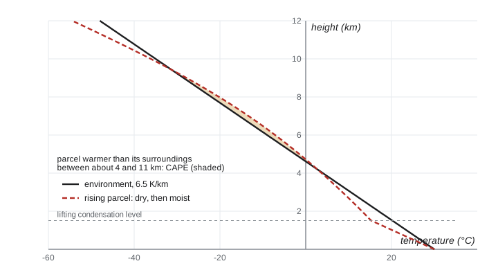
The moist lapse rate ranges from 3.5 K/km in hot, humid air to 9 K/km at \(-40\) °C. A surface parcel at 30 °C with a dew point of 18 °C becomes saturated about 1.5 km up, at 15.3 °C and 815 hPa; the 125 m per degree rule of thumb, which comes from the dry lapse rate of 9.8 K/km and a dew-point lapse rate of about 1.8 K/km, gives the same answer to within 10 m. That is why cumulus bases on a given afternoon are flat and level: every parcel rising from the same well-mixed layer reaches saturation at the same height. The idealized sounding has a convective available potential energy of about 280 J/kg, enough in principle for updrafts of 24 m/s; real prairie thunderstorm soundings often have 1500 to 3000 J/kg, and their updrafts can exceed 40 m/s.
Static stability
Whether a parcel displaced upward keeps rising depends on how its temperature compares with its new surroundings. A dry parcel lifted by \(dz\) cools by \(\Gamma_d\,dz\), while the environment at that height is colder than at the start by \(\Gamma\,dz\). If \(\Gamma < \Gamma_d\), the parcel arrives colder and denser than the air around it and sinks back: the atmosphere is stable. If \(\Gamma > \Gamma_d\), it arrives warmer and accelerates upward: the atmosphere is absolutely unstable. Such superadiabatic layers occur only in the lowest few meters over strongly heated ground, because convection quickly overturns them.
For saturated air the comparison is with \(\Gamma_m\). The common case \(\Gamma_m < \Gamma < \Gamma_d\) is called conditional instability: unsaturated air is stable, but if it is lifted far enough to saturate, its moist ascent can carry it warmer than the environment, and from that level of free convection it rises on its own. The typical tropospheric lapse rate of 6.5 K/km lies in exactly this range, which is why thunderstorms need a trigger, such as a cold front, heating of the ground, or air forced up a slope, to lift air through the stable lower layer, the convective inhibition, before they can develop.
The force on a displaced parcel gives a quantitative measure. Its buoyant acceleration is \(b = g(T_p - T_e)/T_e\). For a small displacement \(\zeta\) of a dry parcel in an environment with lapse rate \(\Gamma\), \(T_p - T_e = -(\Gamma_d - \Gamma)\zeta\), so
When \(N^2 > 0\) the parcel oscillates with the Brunt–Väisälä, or buoyancy, frequency \(N\). For the standard troposphere \(N \approx 0.011\) s\(^{-1}\), a period of about 10 minutes; in the stratosphere \(N\) is about twice as large. These oscillations propagate as internal gravity waves, which appear as rows of lenticular clouds downwind of mountain ranges such as the Rockies and as ripples in noctilucent clouds near the mesopause. When \(N^2 < 0\), the displacement grows exponentially and convection develops.
Convective available potential energy
The total energy a parcel can gain from buoyancy as it rises from its level of free convection to its level of neutral buoyancy is the convective available potential energy
If all of it became kinetic energy, the updraft speed would be \(w = \sqrt{2\,\mathrm{CAPE}}\). Real updrafts are slower because of mixing with drier surrounding air and the weight of condensed water, but CAPE remains the forecaster's main measure of the potential for severe thunderstorms. It depends strongly on low-level moisture: each 1 °C rise in the dew point of the surface air adds roughly 200 to 300 J/kg in a typical summer sounding. Large values over the northern plains and the southern Prairies in June and July, combined with strong wind shear, produce the supercells that bring large hail and tornadoes to the Dakotas and Minnesota.
Clouds and precipitation
Cloud droplets form on aerosol particles called cloud condensation nuclei: sea salt, sulfate, dust and smoke, typically 100 to 1000 per cubic centimeter. Without them, condensation would require air holding several times its saturation vapor content, because of the curvature of tiny droplets; with them, a supersaturation of a few tenths of 1 % suffices. A typical droplet is about 10 µm across and falls at about 1 cm/s, so clouds float. Raindrops are a million times larger in volume and form in two ways. In warm clouds, larger droplets fall faster, collide with smaller ones and grow by coalescence. In clouds colder than 0 °C, which include almost all clouds at mid and high latitudes, the Bergeron process dominates: ice crystals grow at the expense of supercooled droplets, because the saturation vapor pressure over ice is lower than over liquid water. The crystals fall as snow and may melt into rain on the way down. Most of the rain that falls in the northern United States, even in summer, began as snow.
The energy of convection
Moist convection is the main way the lower atmosphere carries heat upward. Of the roughly 160 W/m\(^2\) of sunlight absorbed at the surface on average, about 80 W/m\(^2\) leaves as latent heat of evaporation and is released when the vapor condenses in clouds, and about 17 W/m\(^2\) leaves as sensible heat carried by rising warm air. Without convection, radiation alone would establish a surface temperature far higher and an unstable lapse rate, as Manabe and Strickler showed in 1964; convection adjusts the lapse rate toward the moist adiabat. Lesson 6 returns to this point, because the way the lapse rate changes as the climate warms is one of the important climate feedbacks.
Worked problem
Chinook warming
Air at 2500 m on the crest of the Rockies has a temperature of \(-8\) °C and is unsaturated. It descends to the plains at 1000 m. Estimate its temperature on arrival.
Show solution
- Descending air is compressed adiabatically and warms at the dry rate \(\Gamma_d = 9.8\) K/km.
- The descent is 1.5 km, so the warming is \(9.8\times1.5 = 14.7\) K.
- Arrival temperature: \(-8 + 14.7 \approx 6.7\) °C.
- If the air had earlier risen up the windward side in cloud, losing water as precipitation, it would have cooled at the moist rate on the way up and now warms at the dry rate on the way down, arriving warmer than it started.
Answer: About 7 °C, a warm wind on a winter day.
Common mistakes
MistakeThinking rising air cools because it moves into colder surroundings.
InsteadIt cools because it expands and does work; the surroundings are irrelevant to an adiabatic parcel.
MistakeComparing a parcel's temperature with the environment at its starting height.
InsteadStability compares the parcel with the environment at the height it has reached.
MistakeUsing the moist lapse rate below cloud base.
InsteadAn unsaturated parcel cools at the dry rate until it reaches its lifting condensation level.
MistakeTreating CAPE as a forecast of storms by itself.
InsteadStorms also need a trigger to overcome convective inhibition, and wind shear to organize them.
MistakeBelieving pure water vapor condenses easily into droplets.
InsteadWithout aerosol nuclei, very high supersaturation would be required.
Summary and key terms
- A dry parcel lifted adiabatically cools at \(\Gamma_d = g/c_p \approx 9.8\) K/km; potential temperature \(\theta = T(p_0/p)^{0.286}\) is conserved.
- Saturated parcels cool more slowly, at 3.5 to 9 K/km, because condensation releases latent heat.
- The lifting condensation level, about 125 m per degree of dew-point depression, sets the flat bases of cumulus clouds.
- The atmosphere is stable if the environmental lapse rate is below the parcel's; the common case between the moist and dry rates is conditionally unstable.
- The buoyancy frequency \(N^2 = (g/\theta)\,d\theta/dz\) gives oscillation periods of about 10 minutes; CAPE measures the energy available to thunderstorm updrafts.
- dry adiabatic lapse rate
- The cooling rate g/cp, about 9.8 K/km, of an unsaturated parcel lifted without heat exchange.
- potential temperature
- The temperature a parcel would have if brought adiabatically to 1000 hPa; conserved in dry adiabatic motion.
- lifting condensation level
- The height at which a rising parcel becomes saturated and cloud forms.
- conditional instability
- A lapse rate between the moist and dry adiabatic rates: stable for dry air, unstable once saturated.
- buoyancy frequency
- The natural frequency N of vertical oscillation of a parcel in a stable atmosphere.
- CAPE
- Convective available potential energy: the integral of a parcel's buoyancy from its level of free convection to its equilibrium level.
Practice problems
Work each problem on paper first, then reveal the answer to check.
Find the potential temperature of air at 500 hPa and \(-20\) °C.
Show answer
\(\theta = 253.15\times(1000/500)^{0.286} = 253.15\times1.219 \approx 309\) K.
Estimate the cloud base for surface air at 25 °C with a dew point of 21 °C.
Show answer
\(125\times4 = 500\) m.
An environment cools at 4 K/km. Is it stable for dry parcels? For saturated parcels at 20 °C?
Show answer
It is stable for dry parcels (4 < 9.8); for saturated parcels at 20 °C, \(\Gamma_m \approx 4.2\) K/km, so it is just stable.
Compute the buoyancy period in the stratosphere, where \(T = 217\) K and the lapse rate is zero.
Show answer
\(N^2 = (9.81/217)(9.77\times10^{-3}) = 4.4\times10^{-4}\), \(N = 0.021\) s\(^{-1}\), period about 5 minutes.
A sounding has CAPE of 2500 J/kg. What is the maximum updraft speed in parcel theory?
Show answer
\(\sqrt{5000} \approx 71\) m/s; real updrafts reach perhaps half to two-thirds of this.
Why does saturation vapor pressure over ice being lower than over water help produce precipitation?
Show answer
In mixed clouds the air is supersaturated with respect to ice but subsaturated with respect to water, so crystals grow while droplets evaporate.
Lesson quiz · 5 questions
Score 60% or more to complete this lesson.
Create a free account to save your progress, take quizzes and earn a certificate.