
GEOM-360 · Lesson 12 of 12 · 20 min
Autonomous survey vessels
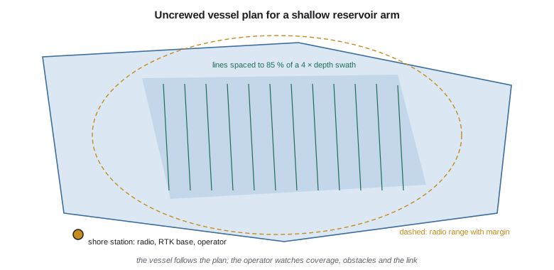
Last autumn's lidar flight mapped most of the reservoir's margins, but one arm defeated it: the inlet where the feeder canal enters, about 52 ha of shallow water, turbid with fine sediment and laced with weed. Too murky for green lidar, too shallow and weedy for the project's boat to survey efficiently, it is exactly where most of the new sediment has gone. Ines proposes an uncrewed surface vessel: a two-meter electric catamaran carrying a compact multibeam, GNSS and a motion sensor, which can run tight lines in half a meter of water for hours while an operator supervises from the shore. Mira has used one for shallow harbor work and lends it, with a technician, for a week.
Uncrewed survey vessels
Uncrewed surface vessels (USVs), sometimes called autonomous surface vessels, range from one-person-portable electric boats for ponds and rivers to ocean-going vessels tens of meters long that cross ocean basins with a control team ashore. In hydrography they are used for three broad purposes: to survey where crewed boats cannot go or should not go, such as very shallow water, contaminated sites, areas below dams or near hazards; to multiply the output of a crewed vessel by running several uncrewed vessels around a mother ship; and to reduce the cost, emissions and risk of routine surveys. Autonomous underwater vehicles (AUVs), which carry multibeam and side-scan close to the seabed in deep water, are a related technology used for deep-water mapping and pipeline routes.
The degree of autonomy varies. Most small survey USVs are remotely supervised: the operator plans the lines, the vessel follows them under its own guidance and control, and the operator watches the data and the surroundings through cameras and radar and can take control at any time. Larger vessels add obstacle detection and avoidance, the ability to replan around hazards, and decision-making for loss of communications. Full autonomy, with no human supervision, is rare in survey work, and regulations everywhere expect a responsible person to be able to intervene.
Payload and integration
A survey USV carries the same sensors as a crewed launch, scaled down: a compact multibeam or single-beam sounder, sometimes side-scan, a GNSS receiver with dual antennas for heading, a motion sensor, a surface sound speed sensor and often a winch-free profiler, plus a computer that logs everything and a communications link. Everything that Lessons 3 to 7 said applies: the sensors must share a time base, the lever arms must be surveyed, and a patch test must be run. The small size makes some things harder: the vessel rolls more in chop, sound speed casts must be made by hand from the bank or a dinghy, or by a probe the vessel lowers itself, and the compact multibeam's beams are wider than the launch's.
Endurance and coverage
An electric USV's endurance is set by its battery and its power draw. Propulsion power rises steeply with speed, roughly with its cube for a small displacement hull, while the sensors and electronics draw a steady amount. Running slower stretches endurance, but the hotel load keeps drawing the battery for longer, so there is a speed beyond which more speed costs more distance per charge than it saves in time. In shallow water, the swath is narrow, so the line spacing is small and the total length of line large; a survey plan must balance speed, endurance and coverage.
import math
# Uncrewed survey vessel (USV) for the reservoir and the harbour's shallow margins
battery_kwh, hotel_kw = 9.6, 0.35            # usable battery energy; sonar, GNSS, radio, computer
def prop_kw(v_kn): return 0.12 * v_kn ** 3 / 8.0   # propulsion power rises with the cube of speed (simple model)
print("speed   power   endurance   line km")
for v in (2.0, 3.0, 4.0, 5.0):
    p = prop_kw(v) + hotel_kw
    hrs = battery_kwh * 0.85 / p                # keep a 15 % reserve
    print(f"{v:4.1f} kn  {p:5.2f} kW  {hrs:6.1f} h   {hrs * v * 1.852:6.1f}")

# Coverage of the reservoir margin: depths 1.5 to 5 m, swath about 4 x depth with a compact multibeam
area_m2 = 520000.0                           # margin area still to survey after the lidar flight
for d in (1.5, 3.0, 5.0):
    spacing = 0.85 * 4.0 * d
    km = area_m2 / spacing / 1000
    print(f"in {d:.1f} m of water: line spacing {spacing:.1f} m, {km:.0f} km of line")

# Mixed-depth plan: average spacing weighted by the share of the area in each depth band
bands = [(1.5, 0.35), (3.0, 0.40), (5.0, 0.25)]
km_total = sum(area_m2 * share / (0.85 * 4.0 * d) / 1000 for d, share in bands)
v = 3.0; p = prop_kw(v) + hotel_kw; hrs = battery_kwh * 0.85 / p
days = km_total / (hrs * v * 1.852)
print(f"total {km_total:.0f} km of line; at {v} kn one charge covers {hrs*v*1.852:.0f} km -> {days:.1f} charges")

# Radio link check for supervised operation: free-space path loss at 2.4 GHz
for dist_km in (0.5, 1.5, 3.0):
    fspl = 20 * math.log10(dist_km) + 20 * math.log10(2400) + 32.44
    margin = 20 + 6 + 6 - fspl - (-90)       # 20 dBm transmit, two 6 dBi antennas, -90 dBm sensitivity
print(f"{dist_km:.1f} km: path loss {fspl:.1f} dB, link margin {margin:.1f} dB")speed power endurance line km 2.0 kn 0.47 kW 17.4 h 64.3 3.0 kn 0.75 kW 10.8 h 60.0 4.0 kn 1.31 kW 6.2 h 46.1 5.0 kn 2.23 kW 3.7 h 34.0 in 1.5 m of water: line spacing 5.1 m, 102 km of line in 3.0 m of water: line spacing 10.2 m, 51 km of line in 5.0 m of water: line spacing 17.0 m, 31 km of line total 64 km of line; at 3.0 kn one charge covers 60 km -> 1.1 charges 0.5 km: path loss 94.0 dB, link margin 28.0 dB 1.5 km: path loss 103.6 dB, link margin 18.4 dB 3.0 km: path loss 109.6 dB, link margin 12.4 dB
At 3 knots the vessel draws 0.75 kW and runs about 11 hours on a charge with a 15 percent reserve, covering 60 km of line; at 2 knots it lasts longer but covers only slightly more line, and at 5 knots it covers barely half as much. In the inlet arm, where depths range from 1.5 to 5 m, lines must be 5 to 17 m apart, and the whole 52 ha needs about 64 km of line: about one full charge at 3 knots, which the technician plans as two half-days so the battery can be changed at midday and the data checked. The radio link has a comfortable margin at 1.5 km and still 12 dB at 3 km, enough for the inlet arm from a single shore station.
Operations and safety
Supervising a USV is a job in itself. The operator plans the lines, sets geofences that the vessel will not cross, and defines what it does if the link is lost, typically stopping, holding position or returning to a safe point. During the survey, the operator watches the vessel's position, the camera view, the incoming data and the coverage map, and stays alert for swimmers, boaters, floating debris and weed that could foul the propellers. Collision regulations still apply on public waters, and the vessel must be visible and, where required, lit and marked. Launch and recovery, often the riskiest part of any small-boat operation, are planned carefully.
In the United States, the Coast Guard applies existing navigation rules to uncrewed vessels, and the regulatory framework for remotely operated and autonomous vessels is still developing; operators commonly work under the inland and international navigation rules, local restrictions and Coast Guard guidance, and consult the Coast Guard for larger or novel operations. On the project's reservoir, Ruth also needs the project's permission, notice to other water users and a plan that keeps the vessel away from the outlet works.
Communications matter as much as propulsion. Small USVs use line-of-sight radio links, sometimes with cellular backup, to send the operator telemetry, camera video and a thinned stream of soundings, while the full data are logged aboard. The link budget, like the one in the code, balances transmitter power and antenna gains against path loss and the receiver's sensitivity; obstructions such as islands, headlands or the reservoir's dam can block it, and a mast for the shore antenna often helps more than more power. Cybersecurity is part of the plan as well: links are encrypted, and the vessel's control system is isolated from other networks.
The inlet arm survey
The survey itself takes two days. On the first morning the technician runs a patch test over the old canal embankment that crosses the arm, a hard, straight feature ideal for pitch, roll and yaw; then the vessel works through the plan while Theo casts a hand profiler from the bank every two hours, finding the warm, shallow water nearly 3 m/s faster in the afternoon than at dawn. Weed fouls a propeller twice and the vessel stops itself on rising motor current, as programmed, until the technician clears it from a canoe. Leah processes each half-day's data that evening. The arm turns out to have shoaled by up to 1.4 m since the 1950s drawings, and the merged surface now covers the whole reservoir with no gaps.
USVs in larger surveys
On the coast, uncrewed vessels are changing how surveys are run. A crewed survey ship can launch one or more USVs that survey parallel lines under supervision, multiplying the ship's coverage; long-endurance USVs survey offshore for weeks with a control team ashore; and small USVs survey the shallow margins of harbours, beaches and estuaries where a launch would risk grounding. National hydrographic offices on both sides of the border have trialled and adopted uncrewed vessels for charting surveys, and specifications are being updated to cover their data. For Northshore, the small USV fills the shallow fringe of the berth survey along the beach north of the terminal, where the launch cannot safely go below half tide.
Bringing it together
The last week of the project brings all three jobs together. The berth survey is delivered to the terminal operator, with the dredging volumes, the contact list, the developed features and a descriptive report prepared to NOAA's specifications so that the survey can be submitted to the Office of Coast Survey once the berth is built. The reservoir's new capacity table, merging lidar, single-beam sonar and the USV's multibeam, shows the loss of storage and the delta at the outlet. The river intake drawings use the cross-sections, the side-scan and the discharge measurement. Ruth reviews the project with the team: Coulee has a marine practice now, built on the same habits that served it on land, control, calibration, uncertainty and honest reporting, applied to a surface that never stops moving.
Looking ahead, the trends are clear: more uncrewed and autonomous platforms, more surveys referenced directly to the ellipsoid, gridded surfaces delivered to ships through S-102 rather than thinned to soundings, crowd-sourced bathymetry from ordinary vessels filling gaps in remote areas, and machine learning helping processors clean data and find objects. None of it changes the core of the profession. A hydrographer still has to know where the vessel was, what the water was doing, how the sound traveled and how certain each depth is, and still has to show the shoalest point.
Worked problem
Endurance at survey speed
An electric USV has 8.0 kWh of usable battery and keeps a 20 percent reserve. At 3 knots its propulsion draws 0.40 kW and its sensors 0.30 kW. How many hours can it survey, and how many kilometers of line will it cover?
Show solution
- \[E = 8.0 \times 0.80 = 6.4\ \text{kWh}\]
- \[t = \frac{6.4}{0.40 + 0.30} = 9.1\ \text{h}\]
- \[s = 9.1 \times 3 \times 1.852 = 50.8\ \text{km}\]
Answer: About 9 hours of survey, covering about 51 km of line.
Common mistakes
MistakeTreating a USV as a toy that needs no calibration.
InsteadIt needs the same lever arms, timing, patch test and sound speed as a launch.
MistakePlanning lines without checking endurance and radio range.
InsteadCompute charges needed and the link budget before mobilizing.
MistakeLeaving the vessel unsupervised on public water.
InsteadKeep a responsible operator able to intervene, with a lost-link plan.
MistakeAssuming one sound speed for a turbid shallow arm all day.
InsteadCast by hand or with the vessel's probe; shallow water warms and changes quickly.
Summary and key terms
- USVs range from small electric boats to ocean-going vessels; most survey USVs are remotely supervised.
- They carry the same integrated sensors as launches and need the same calibration.
- Endurance depends on battery energy and power that rises steeply with speed.
- Shallow water needs close line spacing; plans balance speed, endurance and coverage.
- Operations need geofences, lost-link behavior, collision rules and a link budget.
- The core of hydrography stays the same: position, water level, sound speed, uncertainty and the shoalest point.
- Uncrewed surface vessel (USV)
- A vessel operated without crew aboard, remotely supervised or autonomous.
- Autonomous underwater vehicle (AUV)
- An uncrewed submersible that surveys close to the seabed.
- Remote supervision
- Operation in which the vessel follows a plan while an operator monitors and can intervene.
- Geofence
- A boundary the vessel is programmed not to cross.
- Lost-link behavior
- What the vessel does automatically if communications fail.
- Hotel load
- The steady power drawn by sensors and electronics.
- Link budget
- The balance of transmitter power, gains and losses in a radio link.
Practice problems
Work each problem on paper first, then reveal the answer to check.
If propulsion power rises with the cube of speed, how much more power does doubling speed need?
Show answer
Eight times the propulsion power.
Why does going slower not always increase the line distance per charge?
Show answer
The hotel load keeps drawing power for the longer time.
In 2 m of water with a swath of 4 times depth and 85 percent spacing, what is the line spacing?
Show answer
6.8 m.
Name two things an operator sets before a USV survey.
Show answer
Geofences and lost-link behavior (also the line plan).
What does free-space path loss do as distance doubles?
Show answer
It increases by about 6 dB.
Lesson quiz · 5 questions
Score 60% or more to complete this lesson.
Create a free account to save your progress, take quizzes and earn a certificate.