
GEOM-360 · Lesson 11 of 12 · 18 min
Inland and port surveys
Charting surveys get the attention, but most hydrographic work is done for engineers and operators: ports that must keep their berths at depth, dredging contractors who are paid by the cubic meter, reservoir owners who need to know how much water they can store, and river engineers designing intakes, bridges and flood works. These surveys use the same instruments and the same principles as charting, but they ask different questions, and their results often carry large sums of money. This lesson follows Coulee and Northshore through three such jobs: the dredging of the berth pocket, the reservoir's capacity, and the river intake.
Port surveys
A port lives by its depths. Sediment settles in berths and channels, propeller wash scours the bottom beside wharves, and ships grow larger. Port authorities and terminal operators survey their berths and approaches regularly, often several times a year in areas that silt quickly, and publish the results to pilots and shipping agents as declared depths. Surveys after storms or river floods check for new shoaling; surveys around wharf structures check for scour at the toe of the slope or the face of the wharf, which can undermine them. Many ports now keep their own survey launches, or contract a hydrographer to survey on a fixed schedule, and maintain a history of surfaces that shows where and how fast sediment accumulates.
Dredging surveys
Dredging is designed, controlled and paid for from surveys. The pre-dredge survey defines the starting surface; the design defines the target, a design depth over a defined area with side slopes, plus an allowable overdepth, a band below the design depth within which the contractor is paid for material removed, because no dredger can cut exactly to a line. Progress surveys during the work guide the dredger and show what remains; the post-dredge survey confirms that the design depth has been reached everywhere and measures the volume removed for payment. Because the contractor's payment and the owner's acceptance depend on the difference between two surveys, both must be done to the same standard, on the same datum, with the same methods and preferably by an independent hydrographer, and both parties usually observe or audit them.
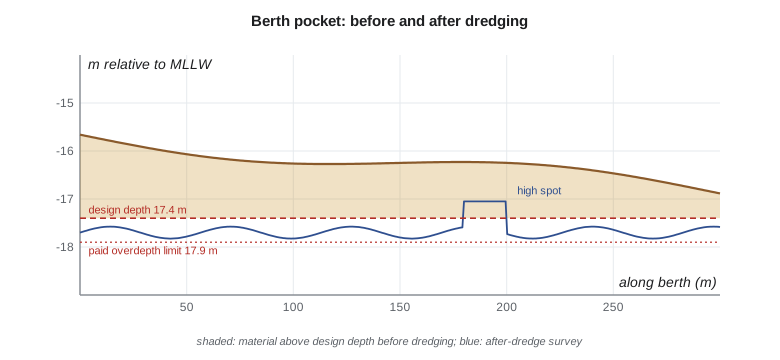
Volumes are computed by comparing surfaces. The older method of average end areas computed cross-sectional areas at regular stations and multiplied their average by the distance between stations; with full-coverage multibeam surveys, volumes are computed directly from the difference between gridded or triangulated surfaces, cell by cell, with rules for what counts: material above the design depth (required), material between the design depth and the overdepth limit (paid if removed), and material removed below the overdepth limit (not paid). Residual high spots above the design depth after dredging must be removed before acceptance.
import math
# Berth pocket 300 m x 60 m on a 5 m grid; pre-dredge seabed below MLLW (smooth synthetic surface)
DES, OVER = 17.4, 0.5        # design depth and allowable (paid) overdepth, m below MLLW
def pre(x, y): return 15.3 + 0.004 * x + 0.9 * math.sin(x / 47.0) * math.cos(y / 23.0) + 0.012 * y
def post(x, y):              # after dredging: mostly cut to between design and design + overdepth
    z = DES + 0.30 + 0.30 * math.sin(x / 9.0) * math.cos(y / 7.0)
    if 180 <= x <= 200 and 20 <= y <= 30: z = DES - 0.35     # an untouched high spot (a 'hump')
    return max(z, pre(x, y))
cell = 25.0
xs = [2.5 + 5 * i for i in range(60)]; ys = [2.5 + 5 * j for j in range(12)]
need = pay = removed = 0.0; humps = []
for x in xs:
    for y in ys:
        z0, z1 = pre(x, y), post(x, y)
        need += max(0.0, DES - z0) * cell                 # to design depth
        removed += (z1 - z0) * cell
        pay += max(0.0, min(z1, DES + OVER) - z0) * cell  # removal counted only down to the paid limit
        if z1 < DES: humps.append((x, y, z1))
print(f"volume above design depth before dredging: {need:,.0f} m3")
print(f"volume removed (pre minus post): {removed:,.0f} m3; payable within the overdepth limit: {pay:,.0f} m3")
print(f"cells still shallower than design after dredging: {len(humps)}, least depth {min(z for *_, z in humps):.2f} m")

# River intake: cross-section from RTK on the banks and single-beam soundings (station m, bed elevation m)
wl = 1027.80                    # water level on the survey day, project vertical datum
sec = [(0, 0.60), (4, -0.20), (9, -1.10), (15, -1.90), (22, -2.40), (30, -2.60),
       (38, -2.30), (45, -1.50), (51, -0.70), (55, 0.15)]       # (station m, bed relative to the water level m)
sec = [(st, wl + dz) for st, dz in sec]
area = perim = 0.0
for (s0, z0), (s1, z1) in zip(sec, sec[1:]):
    d0, d1 = max(0.0, wl - z0), max(0.0, wl - z1)
    if d0 == 0 and d1 == 0: continue
    if d0 == 0 or d1 == 0:      # partly wet panel: cut at the water's edge
        f = (wl - z0) / (z1 - z0); se = s0 + f * (s1 - s0)
        s0, d0 = (se, 0.0) if d0 == 0 else (s0, d0); s1, d1 = (se, 0.0) if d1 == 0 else (s1, d1)
    area += (d0 + d1) / 2 * (s1 - s0); perim += math.hypot(s1 - s0, d1 - d0)
print(f"wetted area {area:.1f} m2, wetted perimeter {perim:.1f} m, hydraulic radius {area/perim:.2f} m, "
f"deepest {wl - min(z for _, z in sec):.2f} m")volume above design depth before dredging: 20,578 m3 volume removed (pre minus post): 25,840 m3; payable within the overdepth limit: 25,744 m3 cells still shallower than design after dredging: 8, least depth 17.05 m wetted area 88.1 m2, wetted perimeter 51.6 m, hydraulic radius 1.70 m, deepest 2.60 m
Before dredging, about 20,600 m³ (about 26,900 cubic yards) lie above the design depth of 17.4 m below MLLW. The post-dredge survey shows 25,840 m³ removed, of which 25,744 m³ falls within the 0.5 m paid overdepth; the rest, cut below 17.9 m, is not paid. Eight cells, all in one patch near the middle of the berth, remain shallower than the design depth, with a least depth of 17.05 m: a high spot that the dredger missed, which must be removed and resurveyed before the berth is accepted. U.S. dredging contracts usually state depths and volumes in feet and cubic yards; the logic is the same.
Dredging surveys bring their own practical problems. Dredged material can leave a soft, low-density layer on the bottom that a high-frequency sounder sees as the seabed and a low-frequency one penetrates. The dredger itself stirs up sediment that scatters sound. Progress surveys must work around the dredger, the barges and the tugs. And sediment keeps settling: the post-dredge survey must be done promptly, before new deposits blur the result.
Dredging and disposal in U.S. waters require permits from the Corps of Engineers under the Rivers and Harbors Act and the Clean Water Act, and ocean disposal is regulated under the Marine Protection, Research, and Sanctuaries Act at designated disposal sites, which are monitored by survey. The Corps' hydrographic manual sets out the survey methods, accuracy classes and volume procedures used on federal dredging contracts.
Reservoir capacity surveys
Reservoirs lose capacity as rivers deliver sediment that settles in the still water. The loss is gradual, perhaps a fraction of a percent a year, but over decades it changes how much water can be stored and released, and sediment collecting near an outlet can block it. Owners resurvey reservoirs periodically and update their elevation-area-capacity tables, which relate water level to surface area and stored volume and are used to operate the reservoir. The project's reservoir had never been resurveyed since it was filled in the 1950s.
Modern capacity surveys combine methods. Lidar maps the dry margins at low water, topobathymetric lidar the clear shallows, multibeam or single-beam sonar the deep water, and an uncrewed vessel the shallow arms where turbidity defeats lidar (Lesson 12). The merged surface is integrated at each water level, from the outlet sill to the spillway crest, to give area and volume. Comparing the new table with the original shows the capacity lost and where the sediment is. For the reservoir, the merged surface built in Lesson 8 shows a loss of about 7 percent of the original capacity, most of it in the upstream arm where the feeder canal enters, and a delta of silt within 40 m of the outlet works. The project plans to monitor the delta yearly with the single-beam boat.
River surveys
River surveys support the design of bridges, intakes, outfalls and flood works, and the hydraulic models that predict water levels in floods. They usually consist of cross-sections at regular intervals, measured by single-beam sonar in the deep parts and by RTK or total station in the shallows and on the banks, joined into a continuous section from bank top to bank top. Water surface elevations are recorded with each section, because a river's surface slopes and changes with flow. Multibeam is increasingly used on larger rivers to map scour holes, pier footings and bedforms in full coverage, and acoustic Doppler current profilers, which measure water velocity through the water column from the Doppler shift of echoes, are used to measure discharge at the same time.
The Sun River intake section shows a wetted area of 88.1 m² and a wetted perimeter of 51.6 m at the survey-day water level, a hydraulic radius of 1.70 m and a maximum depth of 2.60 m. These numbers go into the intake designer's hydraulic calculations, together with the flow measured by the USGS streamgage upstream and an acoustic Doppler discharge measurement Grant takes at the same section. The designer will also want to know how the bed changes in floods; Ines recommends repeating the cross-sections after the next spring runoff.
Structures and inspections
Hydrographers are often asked to inspect structures underwater: the faces of wharves and dams, bridge piers and their scour protection, intake screens, outfall diffusers and pipeline crossings. Multibeam systems that can tilt their swath sideways map vertical faces; side-scan images scour holes and debris; and imaging sonars give near-video pictures in murky water where divers see nothing. These surveys are often repeated to track change, so consistency of method and datum between surveys matters more than absolute accuracy. For the terminal, Northshore's survey includes a sideways multibeam pass along the old wharf face that will be retained as part of the new berth; it shows scour 0.8 m deep at the toe in one place, which the engineers add to the design.
Safety on the water
Inland and port surveys have their own hazards. In ports, survey launches work among ships, tugs and dredgers, often in restricted visibility, and must follow traffic rules and keep in contact with the harbor's traffic service. On rivers, currents, floating debris, weirs and low-head dams are dangerous, and the water is cold for much of the year. On reservoirs, intake structures draw water and boats can be pulled toward them. Grant's plans for each job set out the hazards, the controls, the communication plan and the rescue arrangements, and every crew member wears a flotation device.
Worked problem
Volume between two surveys
A berth cell 5 m × 5 m has a pre-dredge depth of 16.20 m and a post-dredge depth of 17.65 m below the low-water datum. The design depth is 17.40 m with 0.50 m paid overdepth. Find the volume removed, the volume above design that was required, and the payable volume.
Show solution
- \[V_{\text{removed}} = (17.65 - 16.20) \times 25 = 36.25\ \text{m}^3\]
- \[V_{\text{required}} = (17.40 - 16.20) \times 25 = 30.00\ \text{m}^3\]
- \[V_{\text{pay}} = (\min(17.65, 17.90) - 16.20) \times 25 = 36.25\ \text{m}^3\]
Answer: All 36.25 m³ removed is payable because the post-dredge depth lies within the overdepth band.
Common mistakes
MistakeComparing pre- and post-dredge surveys done on different datums or with different methods.
InsteadUse the same datum, methods and standard for both.
MistakePaying for all material removed below the design depth.
InsteadPay only within the allowable overdepth.
MistakeUsing one water level for a river reach.
InsteadRecord the water surface at each cross-section.
MistakeDelaying the post-dredge survey.
InsteadSurvey promptly before new sediment blurs the result.
Summary and key terms
- Ports survey regularly for declared depths, shoaling after storms and scour at structures.
- Dredging uses pre-dredge, progress and post-dredge surveys; payment covers the design depth plus allowable overdepth.
- Volumes come from differencing surfaces with rules for required, paid and unpaid material.
- Reservoir capacity tables integrate merged surfaces at each water level; sediment reduces capacity over time.
- River surveys use cross-sections, water surface elevations and acoustic Doppler discharge.
- Structural inspections need consistent repeat methods; safety plans fit each environment.
- Declared depth
- A depth a port publishes as available in a berth or channel.
- Design depth
- The target depth of a dredging project.
- Allowable overdepth
- A band below the design depth within which removed material is paid for.
- Average end area
- A volume method using cross-sectional areas at stations.
- Elevation-area-capacity table
- A table relating reservoir water level to area and stored volume.
- Hydraulic radius
- Wetted area divided by wetted perimeter of a channel section.
- Acoustic Doppler current profiler
- An instrument measuring water velocity through the water column.
Practice problems
Work each problem on paper first, then reveal the answer to check.
Pre-dredge 15.80 m, post-dredge 18.10 m, design 17.40 m, overdepth 0.50 m. Payable depth of cut?
Show answer
2.10 m (to 17.90 m); 0.20 m below the limit is not paid.
Why must pre- and post-dredge surveys use the same methods?
Show answer
Payment depends on their difference, so systematic differences would be paid as volume.
A river section has area 60 m² and wetted perimeter 40 m. Hydraulic radius?
Show answer
1.5 m.
Why do reservoirs lose capacity?
Show answer
Sediment from inflowing rivers settles in the still water.
What does a sideways-tilted multibeam swath allow?
Show answer
Mapping of vertical faces such as wharves and dams.
Lesson quiz · 5 questions
Score 60% or more to complete this lesson.
Create a free account to save your progress, take quizzes and earn a certificate.