
BIOL-460 · Lesson 9 of 12 · 18 min
Wetlands: types, functions and conservation
▶ Video coming soon A video version of this lesson is on the way.
The class walks into Sedge Fen on a boardwalk of planks laid on the moss. At each step the mat quakes. Sam Whitehorse pushes a peat corer down beside the boardwalk and pulls up a cylinder of brown, fibrous peat; on the third extension, nearly four meters down, the corer finally strikes gray clay. Lena Fournier measures the water in a small pool: pH 6.4, conductance about 90. A kilometer away, across a low ridge of sand, is a small bog the station calls Kettle Bog, its surface a carpet of red and green Sphagnum moss with stunted black spruce. There the pool water has a pH of 4.1 and a conductance below 30. Both are peatlands, both are saturated, yet they are very different ecosystems, and on the lakeshore below, Heron Marsh, with its cattails and open water, is different again. This lesson sorts out the kinds of wetlands, what they do and how they are protected.
What makes a wetland
Wetlands are defined by three linked features. Their hydrology keeps the soil saturated or flooded long enough during the growing season to make it anoxic. Their soils are hydric: waterlogging produces chemical signatures such as gray, gleyed colors, rust-colored mottles where iron has been reduced and reoxidized, or thick layers of undecomposed organic matter. And their vegetation is dominated by hydrophytes, plants adapted to saturated soil. Agencies that map and regulate wetlands use all three, because each can be ambiguous on its own.
Plants survive in waterlogged soil in several ways. Many have aerenchyma, spongy tissue with large air spaces that carries oxygen from the leaves to the roots; some, such as cattails and water lilies, actively ventilate their rhizomes. Others produce adventitious roots near the surface or tolerate anoxia by fermenting stored carbohydrates. The anoxic soil also changes nutrient chemistry: nitrate is lost to denitrification, iron and manganese dissolve, sulfate is reduced to sulfide and organic matter decomposes slowly, so it accumulates.
Kinds of wetlands
In the United States, the classification used by the U.S. Fish and Wildlife Service's National Wetlands Inventory, developed by Lewis Cowardin and colleagues in 1979, groups wetlands and deepwater habitats into five systems: marine, estuarine, riverine, lacustrine and palustrine. Most inland marshes, swamps, bogs and fens fall in the palustrine system, and the classification then divides them by vegetation, such as emergent, scrub-shrub or forested, and by how often they flood. Ecologists also use the familiar descriptive terms bog, fen, marsh and swamp, which this lesson follows.
- Bogs are peatlands fed only by precipitation, which makes them ombrotrophic: acidic, very low in nutrients and dominated by Sphagnum mosses, heath shrubs such as leatherleaf and Labrador tea, and stunted black spruce or tamarack. Sphagnum itself acidifies its surroundings by exchanging hydrogen ions for other cations, and it decays extremely slowly.
- Fens are peatlands fed by groundwater or surface flow that has passed through mineral soil, making them minerotrophic: less acidic and richer in calcium and other nutrients. Sedges, grasses, brown mosses and shrubs dominate, and fens support many rare plants, including orchids.
- Marshes are dominated by emergent herbaceous plants such as cattails, bulrushes, reeds and sedges, usually on mineral soils with water levels that fluctuate seasonally. They are often the most productive wetlands and are prime habitat for waterfowl, muskrats and amphibians.
- Swamps are dominated by trees or tall shrubs, such as eastern white cedar, black ash, silver maple, red maple and alders, on soils that are flooded or saturated for part of the year.
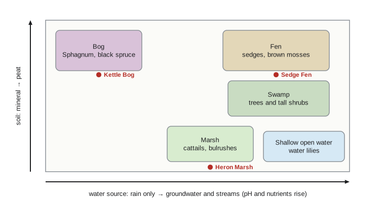
Peatlands accumulate peat because plant production exceeds decomposition in cold, acidic, waterlogged conditions. Peat typically builds up at roughly half a millimeter to a millimeter a year, so the four meters in Sedge Fen represent several thousand years, roughly the time since the land emerged from the glacial lake that once covered the area. In the United States, large peatlands occur in Alaska, northern Minnesota, Wisconsin and Michigan, and in the Everglades and other southern swamps. Over time, a fen can develop into a bog as peat raises the surface above the reach of groundwater, leaving the surface fed only by rain.
What wetlands do
Wetlands are among the most valuable ecosystems per unit area, because they perform several functions at once.
They store water. Wetlands in a watershed absorb snowmelt and storm runoff and release it slowly, lowering flood peaks downstream and sustaining baseflow in dry periods. Studies across the northern Great Plains have found that draining pothole wetlands increases flood volumes in the rivers below.
They improve water quality. Slow flow lets sediment settle; plants and microbes take up nutrients; and denitrification in anoxic soils converts nitrate to nitrogen gas, permanently removing it. Wetlands also bind phosphorus to sediments, though they can release it again if they are drained, overloaded or anoxic for long periods. Constructed wetlands are used to treat agricultural drainage, stormwater and municipal wastewater.
They store carbon. Peatlands cover only a few hundredths of the world's land, yet they hold a very large share of soil carbon, by most estimates more than all the world's forest vegetation. Draining, burning or mining peat releases that carbon as carbon dioxide. At the same time, wetlands are the largest natural source of methane, so their net effect on climate depends on the balance between carbon storage and methane emissions over long periods.
They support biodiversity. Wetlands are breeding and feeding habitat for waterfowl, shorebirds, amphibians, turtles, fish and insects, and a disproportionate share of species at risk depend on them. The Prairie Pothole Region of the northern Great Plains of the United States and the Prairie provinces of Canada, with millions of small depressional wetlands, produces a large share of North America's breeding ducks, which is why it is called the continent's duck factory.
Worked problem
Carbon stored in Sedge Fen
Sedge Fen (synthetic data) covers 32 hectares, with an average peat depth of 3.5 meters. Assume the peat has a dry bulk density of 0.10 grams per cubic centimeter and is 50 parts carbon per 100 by dry mass. Estimate the carbon stored.
Show solution
- Peat volume is 320,000 square meters times 3.5 meters, or 1.12 million cubic meters.
- A bulk density of 0.10 grams per cubic centimeter is 100 kilograms of dry peat per cubic meter, so dry mass is 112 million kilograms.
- Half of that is carbon: about 56 million kilograms, or 56,000 metric tons.
- That is about 1,750 metric tons of carbon per hectare, several times the carbon in the trunks, branches and roots of a mature forest on the same area.
Answer: About 56,000 metric tons of carbon, roughly 1,750 metric tons per hectare.
Heron Marsh, on the lakeshore, also serves the class as a small natural treatment wetland. Bittern Creek's water passes through part of it on the way to Kestrel Lake, and the station measures nitrate at its upstream and downstream edges. Removal in such wetlands is often modeled as first-order decay with residence time:
import math
# Nitrate removal in Heron Marsh (synthetic): first-order rate k per day, residence time tau in days.
c_in = 0.80                 # mg nitrate-nitrogen per L entering
k = 0.35                    # removal rate per day in summer
for tau in (0.5, 1, 2, 4, 8):
    c_out = c_in * math.exp(-k * tau)
print(f"residence {tau:3.1f} d outflow {c_out:.2f} mg/L removed {1 - c_out / c_in:.2f} of the load")residence 0.5 d outflow 0.67 mg/L removed 0.16 of the load residence 1.0 d outflow 0.56 mg/L removed 0.30 of the load residence 2.0 d outflow 0.40 mg/L removed 0.50 of the load residence 4.0 d outflow 0.20 mg/L removed 0.75 of the load residence 8.0 d outflow 0.05 mg/L removed 0.94 of the load
The calculation shows why a wetland's ability to clean water depends on how long water stays in it. Channels cut through a marsh, or a ditch that drains it, short-circuit the flow and cut removal sharply.
Loss and conservation
Wetlands have been drained, filled and dredged on an enormous scale for farming, cities and roads. The lower 48 United States have lost roughly half of the wetlands they had in the 1780s, and some states, including Ohio, Indiana, Illinois, Iowa and California, have lost far more, in some cases nine tenths. Losses continue, although more slowly than in the twentieth century, and many remaining wetlands are degraded by drainage, invasive plants such as the common reed Phragmites, and nutrient and salt pollution.
In the United States, Section 404 of the Clean Water Act requires a permit from the U.S. Army Corps of Engineers, with oversight by the Environmental Protection Agency, to discharge dredged or fill material into waters of the United States, including many wetlands. Permits follow a sequence of avoiding, minimizing and then compensating for unavoidable losses, often through mitigation banks. In Sackett v. Environmental Protection Agency in 2023, the Supreme Court held that the act covers only wetlands with a continuous surface connection to other regulated waters, which removed federal protection from many isolated and seasonal wetlands and left their protection to the states. The Swampbuster provisions of the farm bill also discourage draining wetlands on farms that receive federal payments. Both countries cooperate with Mexico under the North American Waterfowl Management Plan, begun in 1986, which has funded the protection and restoration of millions of hectares of wetland habitat, and both are parties to the Ramsar Convention on Wetlands of International Importance, signed in 1971.
Restoration is possible but slow. Plugging drainage ditches and breaking tile drains can restore the hydrology of a marsh within a year, and plants and invertebrates often return within a few years, but restored wetlands commonly take decades to match natural ones in soil carbon and plant diversity, and peatlands take centuries to millennia. Beavers are increasingly recognized as partners in restoration: their dams raise water tables, create ponds and wet meadows, trap sediment and slow floods, and in some places restoration teams build simple structures that mimic beaver dams to encourage beavers to return. On Bittern Creek, the beaver ponds above the lake are among the most productive habitats the class samples, and the station's long record shows that they also hold back sediment and phosphorus during spring floods.
Animals of wetlands
Many animals depend on wetlands for at least part of their lives. Frogs, toads and salamanders breed in wetland pools, and some species, such as wood frogs and spotted salamanders, need temporary pools that dry in late summer, because the drying keeps out the fish that would eat their eggs and larvae. These vernal pools are often too small to appear on maps and are easily lost to drainage or filling. Turtles nest on dry ground near wetlands and spend the rest of the year in the water, and road mortality of nesting females is a major threat to several species at risk. Waterfowl use different wetlands at different seasons: shallow, seasonal wetlands that warm quickly in spring are rich in invertebrates that laying females need for protein, while larger, permanent marshes provide brood habitat and refuges during molt. Muskrats and beavers create open water and lodges that other species use, and dragonflies, which spend most of their lives as aquatic nymphs, are among the most visible wetland insects. Because so many species depend on networks of wetlands of different sizes and permanence, losing the smallest, most temporary wetlands can harm populations that also use the larger ones.
Delineating a wetland
Regulating wetlands requires knowing exactly where they begin and end. Delineation is the field procedure for drawing that boundary. Delineators examine the three indicators in turn: they identify the dominant plants and check whether most are species that usually occur in wetlands; they dig soil pits to look for hydric soil features such as gleyed colors, mottles or organic layers; and they look for signs of wetland hydrology, such as standing water, saturated soil near the surface, water marks on trees or drift lines. The boundary is placed where the indicators change, and it is surveyed and mapped. Because wetland conditions vary with season and weather, delineations are usually done in the growing season and checked against aerial photographs and records from wetter and drier years. The class practices on the edge of Heron Marsh, where the change from cattails and gleyed soil to aspen and well-drained sand happens over about ten meters.
Common mistakes
MistakeAll wetlands are swamps.
InsteadSwamps are wooded wetlands; bogs, fens, marshes and shallow open water are distinct types with different water sources, soils and plants.
MistakeWetlands always remove phosphorus.
InsteadThey often retain it, but drained, overloaded or long-anoxic wetlands can release phosphorus.
MistakeA newly flooded wetland is equivalent to the one that was lost.
InsteadHydrology may return quickly, but soils, carbon and plant communities take decades or longer to recover.
Summary and key terms
- Wetlands are defined by saturated hydrology, hydric soils and hydrophytic vegetation.
- Bogs are rain-fed, acidic peatlands; fens are groundwater-fed peatlands; marshes are herbaceous and swamps wooded.
- Wetlands store water, improve water quality, store carbon and support many species, including breeding waterfowl.
- Nitrate removal in a wetland depends strongly on how long water stays in it.
- Large historical losses continue; protection depends on federal, provincial or state and international policies, and restoration is slow.
- Hydric soil
- Soil formed under saturation long enough to become anoxic, with characteristic colors or organic layers.
- Hydrophyte
- A plant adapted to growing in water or saturated soil.
- Ombrotrophic
- Fed only by precipitation, as in bogs.
- Minerotrophic
- Fed by water that has passed through mineral soil, as in fens.
- Peat
- Partly decomposed plant material that accumulates in waterlogged conditions.
- Aerenchyma
- Plant tissue with air spaces that carries oxygen to submerged roots.
Practice problems
Work each problem on paper first, then reveal the answer to check.
A wetland removes nitrate at a first-order rate of 0.5 per day. What fraction remains after 2 days?
Show answer
About 0.37, since e to the power minus 1 is about 0.37.
Why is bog water so acidic?
Show answer
Bogs receive only rain, which is low in buffering ions, and Sphagnum releases hydrogen ions.
Name two ways beavers change streams.
Show answer
Their dams raise water tables and create ponds; they also trap sediment and slow floods.
Lesson quiz · 5 questions
Score 60% or more to complete this lesson.
Create a free account to save your progress, take quizzes and earn a certificate.