
BIOL-460 · Lesson 1 of 12 · 21 min
Freshwater habitats: lakes, rivers, wetlands and their watersheds
▶ Video coming soon A video version of this lesson is on the way.
Aquatic ecology asks how life works in water: how organisms are shaped by the physics and chemistry of lakes, rivers and wetlands, how they interact with one another, and how whole water bodies respond when people change the land and air around them. This course builds directly on BIOL-208, Principles of Ecology. The population models, food web ideas and nutrient cycles from that course reappear here, but now in a medium that is dense, slow to warm, poor in oxygen and full of dissolved and suspended material. Those properties make aquatic ecosystems behave very differently from forests and grasslands, and they are the reason this course spends its first few lessons on light, heat and chemistry before turning to plankton, invertebrates and fish.
The running example for all twelve lessons is an invented research site, the Kestrel Lake Field Station, in the lake country of northern Wisconsin near Boulder Junction. The station director, Dr. Ingrid Solberg, is a limnologist who has sampled the same lakes every two weeks for twenty years. Marcus Achebe runs the fish program, Lena Fournier is a graduate student studying phytoplankton, and Sam Whitehorse is a field technician who also works with the water program of a neighboring Ojibwe nation. Each summer a class of undergraduate students joins them for a field course, and this course follows that class. All station data in the lessons are synthetic, invented to be realistic, and labeled as such; facts about real places, studies and laws are real.
The station studies four water bodies. Kestrel Lake is deep, cold and clear, with lake trout in its depths and a forested watershed of thin soil over granite. Mallard Lake, a few kilometers downstream, is shallow and green, surrounded by dairy pasture, corn fields and cottages, and has had blooms of blue-green algae in most recent summers. Bittern Creek flows into Kestrel Lake through a forested valley, and Sedge Fen and Heron Marsh are wetlands on the creek and the lakeshore. Together they let the class compare a nutrient-poor lake with a nutrient-rich one, a lake with a stream, and open water with wetland.
Why fresh water matters
Fresh water is scarce on a planetary scale. Only about one liter in every forty of the water on Earth is fresh, and most of that is locked in glaciers, ice caps and groundwater. Lakes, rivers and wetlands together hold well under one hundredth of the fresh water, and they cover less than a hundredth of the land surface. Yet freshwater habitats hold roughly one in ten described animal species, including about a third of all vertebrate species, because their patchy, isolated nature encourages local adaptation and speciation. They also supply most drinking water, irrigation and inland fisheries, and they receive almost everything that washes off the land.
That combination of high diversity, small area and heavy human use makes fresh waters among the most threatened ecosystems on Earth. Assessments of freshwater vertebrate populations have found steeper average declines than in terrestrial or marine populations, driven by habitat loss, dams, pollution, overharvest, invasive species and climate change. Many of these pressures are the subject of Lessons 9 to 12.
The United States shares the Laurentian Great Lakes with Canada; together they hold about a fifth of the world's surface fresh water. Wisconsin alone has more than 15,000 lakes and Minnesota more than 10,000, most of them formed when the last ice sheet retreated about 10,000 to 12,000 years ago, and Alaska has millions more. Knowing how a lake formed tells an ecologist a great deal about its depth, shape and chemistry.
Standing and running water
Ecologists divide inland waters into lentic, or standing, habitats such as lakes, ponds and many wetlands, and lotic, or running, habitats such as streams and rivers. The difference is more than speed. In a lake, water stays for months or years, so organisms experience the slow seasonal changes of one body of water, and plankton can live their whole lives suspended in it. In a stream, water moves downstream in hours or days, so the community is dominated by organisms that cling to the bottom or swim against the current, and much of the food arrives from the land. Wetlands sit between the two and between water and land: their soils are saturated for long enough that plants and microbes adapted to low oxygen dominate.
Lakes form in several ways. Glacial lakes are by far the most common in northern North America. Ice scoured basins into bedrock, as on the Canadian Shield, or left blocks of ice buried in sediment that later melted to form kettle lakes, as across much of Wisconsin, Minnesota and Michigan. Other lakes are tectonic, formed where the crust has dropped, as in the deep rift lakes of East Africa and Lake Baikal; volcanic, filling craters; or fluvial, such as the oxbow lakes left when a meandering river cuts off a loop. Reservoirs, made by damming rivers, are now so numerous that they cover a large share of the world's lake area, and they behave partly like lakes and partly like slow rivers.
The zones of a lake
A lake is not uniform. Near the shore, where light reaches the bottom, is the littoral zone, home to rooted plants, attached algae and a rich community of invertebrates and young fish. Offshore, the open water is the pelagic or limnetic zone, where phytoplankton and zooplankton drift and open-water fish feed. The bottom beneath the open water, below the depth where light is enough for photosynthesis, is the profundal zone, a dark region supplied with food only by material that sinks from above. The benthic zone is the whole lake bottom, from the shore to the deepest point, and its organisms are called the benthos.
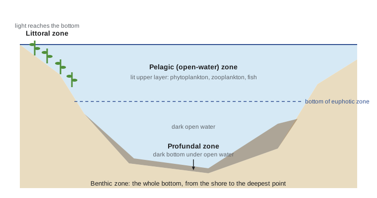
The boundary between the littoral and profundal zones is set by light, so it moves. In clear Kestrel Lake, rooted plants grow to about 7 meters and the bottom is lit almost to 15 meters. In green Mallard Lake, algae in the water shade the bottom, and plants grow only to about 2 meters. One of the first things the class does is map these zones with a Secchi disk and an underwater light meter, which Lesson 2 explains.
Describing the shape of a lake
The size and shape of a basin, its morphometry, control much of how a lake works. The key measurements are surface area, maximum depth, mean depth and volume. Mean depth is volume divided by area, and it is often more useful than maximum depth: a lake with a large mean depth has a large volume of deep, cold water relative to its productive shallow margin. Limnologists also draw a hypsographic curve, the area of the lake at each depth, from a bathymetric map. The curve shows, for example, how much bottom lies in the lit zone and how much water lies below a summer thermocline.
Shoreline development compares the length of the shoreline with the circumference of a circle of the same area. It is defined as
where \(L\) is the shoreline length and \(A\) the surface area. A perfectly round lake has \(D_L = 1\); a lake with many bays and points has a larger value, more littoral habitat and more contact with its watershed. Many Shield lakes, with their irregular bedrock shorelines, have values of 3 or more.
The most important single number for many questions is the water residence time, the average time water spends in the lake. It is the volume divided by the rate of outflow:
A lake with a long residence time keeps the nutrients and contaminants it receives for a long time and responds slowly to change; a lake with a short residence time is flushed quickly and behaves more like a widened river. Residence time also appears in the nutrient models of Lesson 4.
Worked problem
Residence time of Kestrel Lake
Kestrel Lake (synthetic data) has a surface area of 2.4 square kilometers and a mean depth of 11 meters. Its outflow averages 0.21 cubic meters per second. Find its volume and its water residence time in years.
Show solution
- Volume is area times mean depth: 2.4 million square meters times 11 meters is 26.4 million cubic meters.
- Outflow per year is 0.21 cubic meters per second times about 31.6 million seconds in a year, or about 6.6 million cubic meters.
- \[\tau_w = \frac{26.4 \times 10^{6}\ \text{m}^3}{6.6 \times 10^{6}\ \text{m}^3/\text{yr}} \approx 4.0\ \text{yr}\]
- On average, water stays in Kestrel Lake for about four years before leaving by the outlet.
Answer: Volume about 26.4 million cubic meters; residence time about 4 years.
The class computes the same quantities for both lakes in a few lines of Python. The values are the station's synthetic data.
import math
lakes = {
    'Kestrel': dict(area_km2=2.4, mean_depth_m=11.0, shore_km=19.5, outflow_m3s=0.21),
    'Mallard': dict(area_km2=0.85, mean_depth_m=3.2, shore_km=4.6, outflow_m3s=0.24),
}
for name, d in lakes.items():
    A = d['area_km2'] * 1e6                      # m2
    V = A * d['mean_depth_m']                    # m3
    Q = d['outflow_m3s'] * 365.25 * 86400        # m3 per year
    DL = d['shore_km'] * 1000 / (2 * math.sqrt(math.pi * A))
print(f"{name:8s} volume {V/1e6:5.1f} million m3 residence {V/Q:4.2f} yr shoreline development {DL:.1f}")Kestrel volume 26.4 million m3 residence 3.98 yr shoreline development 3.6 Mallard volume 2.7 million m3 residence 0.36 yr shoreline development 1.4
Mallard Lake holds about a tenth of the water of Kestrel Lake but receives more flow, because its watershed is larger, so water passes through it in a few months. That short residence time will matter when the class asks how quickly Mallard Lake could recover if its nutrient inputs were cut.
The lake and its watershed
Every lake and stream is the product of its watershed, the area of land that drains to it, called a catchment or drainage basin. In 1887 the American naturalist Stephen Forbes described a lake as a microcosm, a little world complete in itself. The image helped found limnology, but later ecologists turned it around. Long-term studies such as those at the Hubbard Brook Experimental Forest in New Hampshire showed that what a stream carries is set largely by the forest, soils and rock it drains, and the British stream ecologist Noel Hynes summed up the idea in the phrase that the valley rules the stream. Modern aquatic ecology treats water bodies as open systems connected to the land, the air, groundwater and each other.
Three features of a watershed matter most. The first is its size relative to the lake: a lake with a small catchment receives little water and few nutrients, while a lake with a large one is strongly shaped by inflow. The second is geology. Lakes on the granite and gneiss of the Canadian Shield, which extends into northern Wisconsin and Minnesota, sit on hard rock that weathers slowly and releases few ions, so their water is soft, poorly buffered against acids and low in nutrients. Lakes on limestone or on the clay-rich glacial till of farm country are hard, well buffered and richer in nutrients. The third is land use. Forest and wetland retain nutrients and sediment; cropland, pasture, lawns and pavement release them.
Kestrel Lake has a catchment of about 18 square kilometers, almost all forest and wetland, roughly seven times the lake's area. Mallard Lake drains about 40 square kilometers, nearly fifty times its area, and about half of it is farmland. Those two numbers already predict much of what the class will measure: soft, clear, nutrient-poor water in Kestrel Lake and nutrient-rich, turbid water in Mallard Lake.
Running waters and wetlands in brief
Streams are organized into networks. In the Strahler system, the smallest permanent channels are first-order streams; two first-order streams join to form a second-order stream, two second-order streams form a third-order stream, and so on. Most of the total channel length in any network is in small headwater streams, which is why their protection matters so much for water quality downstream. Bittern Creek is a third-order stream where it enters Kestrel Lake. Lesson 8 follows its changes from headwaters to mouth.
Wetlands are lands where water saturates the soil long enough to produce hydric soils and plants adapted to them. They include peat-forming bogs and fens and mineral-soil marshes and swamps, and they store water, trap sediment, remove nitrogen, store carbon and support many species. Sedge Fen and Heron Marsh are the station's examples, and Lesson 9 is devoted to wetlands.
Who looks after fresh water
In the United States, the Clean Water Act of 1972 is the main federal water law. The Environmental Protection Agency sets national rules and approves water quality standards, which states and authorized tribes write and enforce, and the U.S. Geological Survey runs the national stream gauging and water quality monitoring networks. Several dozen tribes have authority to set their own water quality standards, and many tribal natural resources departments monitor lakes and streams. Boundary waters such as the Great Lakes are governed under the Boundary Waters Treaty of 1909 with Canada, with the help of the International Joint Commission. The laws and agencies return in Lessons 9 and 11.
How aquatic ecologists sample
Fieldwork in aquatic ecology relies on a small set of classic tools and a growing set of sensors. The Secchi disk, a black-and-white disk lowered until it disappears, measures water clarity. Water bottles such as the Van Dorn sampler close at a chosen depth to collect water for chemistry and plankton counts. Multiparameter sondes record temperature, dissolved oxygen, conductivity, pH, chlorophyll fluorescence and turbidity as they are lowered through the water. Plankton nets, bottom grabs, kick nets and fish nets sample organisms. Increasingly, buoys with sensor strings record conditions every few minutes all summer, and networks of such buoys around the world, such as the Global Lake Ecological Observatory Network, let researchers compare lakes on several continents.
Sam Whitehorse adds a reminder on the first day. Long before the station existed, the lakes were known in detail by the people who fished, traveled and harvested rice and medicines on them, and that knowledge includes changes in ice, water levels and fish that no instrument recorded. The station's monitoring plan includes observations from the nation's natural resources staff and elders, shared under an agreement that sets out how the information may be used. Lesson 12 returns to how such knowledge and scientific data can be brought together.
Common mistakes
MistakeA lake is a closed system that can be understood on its own.
InsteadLakes are open systems; their water, nutrients and many organisms come from the watershed, air and groundwater.
MistakeMaximum depth is the best single measure of a lake's depth.
InsteadMean depth, volume divided by area, says more about how much deep water a lake has and how productive it is likely to be.
MistakeAll lakes respond quickly once pollution stops.
InsteadA lake with a long residence time keeps what it has received for years; flushing time and internal recycling slow recovery.
Summary and key terms
- Fresh waters cover a tiny share of Earth but hold a large share of its species and are heavily used and threatened.
- Lentic waters stand; lotic waters run; wetlands have saturated soils and low-oxygen-adapted plants and microbes.
- Lakes have littoral, pelagic, profundal and benthic zones, with boundaries set largely by light.
- Morphometry, including mean depth, shoreline development and residence time, shapes how a lake functions.
- Watershed size, geology and land use explain much of the difference between lakes such as Kestrel and Mallard.
- Limnology
- The study of inland waters: their physics, chemistry, biology and geology.
- Littoral zone
- The shallow margin of a lake where light reaches the bottom and rooted plants can grow.
- Pelagic zone
- The open water of a lake away from the shore and bottom.
- Profundal zone
- The dark bottom beneath the open water, below the depth of effective light.
- Residence time
- The average time water stays in a lake: volume divided by outflow.
- Watershed
- The land area that drains to a stream, lake or wetland; also called a catchment or drainage basin.
Practice problems
Work each problem on paper first, then reveal the answer to check.
A lake has a volume of 12 million cubic meters and an outflow of 3 million cubic meters a year. What is its residence time?
Show answer
4 years.
Why do lakes on granite bedrock tend to have soft, nutrient-poor water?
Show answer
Granite weathers slowly and releases few dissolved ions or nutrients.
Two second-order streams join. What is the order of the stream below the junction?
Show answer
Third order.
Lesson quiz · 5 questions
Score 60% or more to complete this lesson.
Create a free account to save your progress, take quizzes and earn a certificate.