
BIOL-460 · Lesson 8 of 12 · 18 min
Rivers and streams: flow, habitat and the river continuum
▶ Video coming soon A video version of this lesson is on the way.
Bittern Creek rises in a spruce bog on the height of land north of the station, tumbles over granite ledges through a mixed forest, slows into a series of beaver ponds, and enters Kestrel Lake across a sandy delta. Below the lake's outlet it continues as the Kestrel River, which joins a larger river some 40 kilometers downstream. In a single afternoon the class samples four points along the creek: a shaded first-order rivulet a meter wide, a riffle on the third-order main stem, a beaver pond and the delta. The invertebrates, the algae and even the color of the water change at every stop. This lesson explains why, using the concepts stream ecologists have built to understand running water.
Flow
The defining feature of a stream is that its water moves, and the most basic measurement is discharge: the volume of water passing a point per unit time, in cubic meters per second. Hydrologists measure it by dividing a cross-section of the channel into vertical panels, measuring the width, depth and mean velocity of each, and summing their products. Mean velocity in each panel is measured with a current meter at about six tenths of the depth below the surface, where velocity in a typical profile is close to the average.
Worked problem
Measuring discharge
The class measures a riffle on Bittern Creek in five panels, each 0.8 meters wide (synthetic data). Depths are 0.12, 0.25, 0.31, 0.22 and 0.10 meters, and mean velocities 0.18, 0.42, 0.51, 0.37 and 0.15 meters per second. Find the discharge.
Show solution
- Multiply depth by velocity in each panel: 0.022, 0.105, 0.158, 0.081 and 0.015 square meters per second.
- Their sum is about 0.381; multiplied by the panel width of 0.8 meters, it gives the discharge.
- \[Q \approx 0.8 \times 0.381 \approx 0.30\ \text{m}^3\,\text{s}^{-1}\]
- So about 300 liters of water pass the riffle each second.
Answer: About 0.30 cubic meters per second.
Discharge changes constantly. A hydrograph, a graph of discharge over time, shows a stream's baseflow, fed by groundwater between storms, and its stormflow peaks after rain or snowmelt. The U.S. Geological Survey operates the national network of streamgages, many in cooperation with states and other agencies, and their long records show each river's natural flow regime: the typical magnitude, frequency, duration, timing and rate of change of flows. Stream ecologists consider the flow regime a master variable, because floods scour and rebuild habitat, low flows concentrate organisms and warm the water, and the timing of high flows cues fish spawning and insect emergence. Many organisms are adapted not to average conditions but to a particular pattern of variation, so altering that pattern with dams, diversions or urban runoff can harm them even when average flow is unchanged.
Habitat in running water
Streams with gravel or cobble beds typically alternate between riffles, shallow, fast, turbulent reaches over coarse substrate, and pools, deeper, slower reaches where fine sediment and organic matter collect; runs and glides lie between. Riffles are well oxygenated and support the richest invertebrate communities; pools shelter fish, especially in low flow and winter. Wood that falls into a stream creates pools, traps leaves and gravel, and provides cover, so forested streams with plenty of wood are usually more diverse than cleared ones.
Water also flows through the bed. The hyporheic zone is the saturated gravel beneath and beside the channel where stream water and groundwater mix. It is a nursery for many invertebrates, a site of intense microbial processing of nutrients, and the place where trout and salmon bury their eggs, relying on flowing water to bring oxygen and remove wastes. Fine sediment from eroding banks, roads or fields clogs the gravel and suffocates eggs, one of the most widespread forms of stream degradation.
Organisms in fast water show striking adaptations. Many mayfly nymphs are flattened and cling to the undersides of stones, where the current is weakest in a thin boundary layer. Blackfly larvae attach with a ring of hooks and filter food with fans on their heads. Net-spinning caddisflies build silk nets to catch drifting particles, while case-building caddisflies add stones to their cases as ballast. Many invertebrates also deliberately let go and drift downstream, mostly at night when trout cannot see them, colonizing new habitat; the downstream loss is thought to be balanced by upstream flight of egg-laying adults.
Energy from the land
In a small forested stream, the canopy shades the water so heavily that algae grow little, yet the stream supports a rich community. Its food comes mainly from the land, as leaves, needles, twigs and dissolved organic matter: allochthonous inputs, produced outside the stream, as opposed to autochthonous production by algae and plants within it. A shaded headwater stream may receive several hundred grams of leaf litter per square meter each autumn.
Leaves are processed in steps. Dissolved compounds leach out within days. Fungi, especially aquatic hyphomycetes, and bacteria colonize the leaf and soften it, a process called conditioning that also makes it more nutritious. Invertebrates then shred the conditioned leaf into fine particles, which are collected and eaten by other animals downstream. Stream ecologist Kenneth Cummins grouped invertebrates by how they feed rather than by taxonomy, into functional feeding groups:
- Shredders, such as some stoneflies, caddisflies and amphipods, chew coarse particulate organic matter such as leaves.
- Collector-gatherers, such as many mayflies and midges, pick up fine particles from the bottom.
- Collector-filterers, such as blackflies, net-spinning caddisflies and mussels, strain fine particles from the current.
- Scrapers or grazers, such as snails and flattened mayflies, scrape periphyton from surfaces.
- Predators, such as stonefly, dragonfly and hellgrammite larvae, eat other animals.
The river continuum concept
In 1980 Robin Vannote and colleagues brought these ideas together in the river continuum concept. They proposed that a river system, from headwaters to mouth, forms a continuous gradient of physical conditions, and that biological communities shift predictably along it.
- In shaded headwaters of first to third order, food comes mainly from leaves. Respiration exceeds photosynthesis, so the ratio of production to respiration is below 1, and shredders and collectors dominate.
- In wider, mid-order streams of about fourth to sixth order, the canopy opens, sunlight reaches the bed and periphyton production rises. Production can exceed respiration, and scrapers become abundant alongside collectors.
- In large rivers, depth and turbidity limit light at the bottom, and the main food is fine particles carried from upstream. The production-to-respiration ratio falls below 1 again, collectors dominate the benthos, and phytoplankton can develop in slow water.
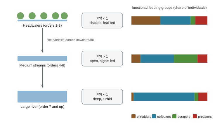
The concept also predicts that diversity peaks in mid-order streams, where temperature varies most and food is most varied. It was developed for forested rivers of eastern North America and has been tested and revised many times. Dams interrupt the continuum, resetting conditions below them; the serial discontinuity concept describes how a reservoir makes the river below it colder, clearer and steadier, like a stream further upstream. In large rivers with floodplains, the flood pulse concept emphasizes that annual flooding of the floodplain, not material from upstream, drives much of the productivity, as fish and invertebrates move onto flooded land to feed and breed. Lakes and beaver ponds along a stream, like those on Bittern Creek, also break the continuum, and newer approaches treat rivers as branching networks in which tributary junctions create patches of distinct habitat.
# Functional feeding groups (share of individuals) at three Bittern Creek sites, synthetic data.
sites = {
    'first-order rivulet': dict(shredders=38, gatherers=30, filterers=8, scrapers=6, predators=18),
    'third-order riffle':  dict(shredders=12, gatherers=25, filterers=19, scrapers=31, predators=13),
    'below the beaver ponds': dict(shredders=5, gatherers=34, filterers=41, scrapers=8, predators=12),
}
for site, g in sites.items():
    n = sum(g.values())
    top = max(g, key=g.get)
    ratio = g['scrapers'] / (g['shredders'] + g['gatherers'] + g['filterers'])
print(f"{site:24s} most common: {top:9s} scrapers to collectors and shredders: {ratio:.2f}")first-order rivulet most common: shredders scrapers to collectors and shredders: 0.08 third-order riffle most common: scrapers scrapers to collectors and shredders: 0.55 below the beaver ponds most common: filterers scrapers to collectors and shredders: 0.10
The class's results fit the concept in outline: shredders are most common in the shaded rivulet, scrapers in the open riffle, and filterers below the beaver ponds, which export fine particles and plankton like miniature lakes.
Nutrient spiralling
In a lake, a nutrient atom can cycle between water and organisms in one place. In a stream, it is carried downstream while it cycles, so its path is a spiral. The spiralling length is the average distance a nutrient atom travels during one complete cycle from dissolved form, into organisms and back. It has two parts: the uptake length, the distance traveled in dissolved form before being taken up, and the turnover length, the distance traveled inside organisms before being released. Short spiralling lengths mean a stream retains and processes nutrients efficiently.
Ecologists measure uptake length by releasing a nutrient together with a conservative tracer such as salt or bromide and measuring how the nutrient-to-tracer ratio falls downstream. The ratio declines exponentially, and the uptake length is the inverse of the decline rate.
import math
# Phosphate added with bromide at the top of a 200 m reach of Bittern Creek (synthetic data).
dist = [0, 50, 100, 150, 200]                    # m downstream
ratio = [1.00, 0.79, 0.62, 0.50, 0.39]           # phosphate:bromide, relative to the release point
n = len(dist); y = [math.log(r) for r in ratio]
mx, my = sum(dist) / n, sum(y) / n
k = -sum((d - mx) * (v - my) for d, v in zip(dist, y)) / sum((d - mx) ** 2 for d in dist)
print(f"decline rate {k:.4f} per m; phosphate uptake length about {1 / k:.0f} m")decline rate 0.0047 per m; phosphate uptake length about 214 m
Streams with abundant algae, wood, leaf packs and hyporheic exchange take up nutrients quickly. Channelized, sediment-choked or scoured streams have long uptake lengths and pass nutrients downstream, one reason headwater stream protection matters for the lakes and coastal waters below.
Riparian zones and human pressures
The riparian zone, the strip of land along a stream, shades the water, keeps it cool, supplies leaves and wood, stabilizes banks with roots and filters runoff. Forested buffers of a few tens of meters can remove much of the sediment and nitrogen in overland flow. Many streams in farm country have lost their riparian trees, and planting buffer strips is among the most common restoration practices.
Urbanization changes streams profoundly. Pavement and storm sewers send rain to streams in minutes rather than days, so floods are higher and more frequent, baseflow falls, channels erode and widen, and water carries nutrients, metals, salt and heat. The resulting set of symptoms is called the urban stream syndrome, and many studies have found that sensitive invertebrates decline once roughly a tenth of a watershed is covered by impervious surfaces. Dams, culverts and weirs fragment river networks, blocking the movement of fish and changing flow and temperature. Removing obsolete dams is now a major restoration tool; the removal of two large dams on the Elwha River in Washington State between 2011 and 2014, the largest dam removal in history at the time, released sediment that rebuilt the river's delta and reopened habitat that salmon recolonized within a few years.
Temperature is another master variable in streams. Small streams track air temperature closely unless they are shaded or fed by groundwater, which emerges at roughly the mean annual air temperature and so keeps spring-fed reaches cool in summer and ice-free in winter. Brook trout, which do poorly above about 20 degrees, depend on such cold-water reaches and on cold tributary mouths where they gather on hot days. Removing riparian shade, widening a channel or building a pond on a stream can raise summer temperatures by several degrees, enough to eliminate trout. Temperature loggers placed along Bittern Creek every few hundred meters show the effect of a single beaver pond clearly: water leaving the pond in late July is about 4 degrees warmer than water entering it, and the trout below the pond move into a spring-fed side channel until autumn.
Common mistakes
MistakeA stream's ecology depends only on its average flow.
InsteadOrganisms are adapted to the whole flow regime: floods, low flows, timing and rates of change.
MistakeHeadwater streams get most of their energy from algae.
InsteadShaded headwaters depend mainly on leaves and other inputs from the land.
MistakeThe river continuum concept applies the same way to every river.
InsteadDams, lakes, floodplains and tributary junctions break or reshape the continuum; it is a framework, not a law.
Summary and key terms
- Discharge, measured as width times depth times velocity, varies around a characteristic natural flow regime.
- Riffles, pools, wood and the hyporheic zone create stream habitat; fine sediment degrades it.
- Headwater food webs run on leaves processed by microbes and shredders; invertebrates are grouped by feeding function.
- The river continuum concept predicts shifts in production, respiration and feeding groups from headwaters to large rivers.
- Nutrients spiral downstream; riparian buffers, urban runoff and dams strongly affect stream ecosystems.
- Discharge
- The volume of water flowing past a point per unit time.
- Hyporheic zone
- The saturated sediment beneath and beside a stream where stream and groundwater mix.
- Allochthonous
- Produced outside the water body and carried in, such as leaves from the riparian forest.
- Functional feeding group
- A group of invertebrates that obtain food in the same way, such as shredders or scrapers.
- River continuum concept
- The idea that river communities change predictably along the gradient from headwaters to mouth.
- Uptake length
- The average distance a dissolved nutrient travels downstream before it is taken up.
Practice problems
Work each problem on paper first, then reveal the answer to check.
A panel is 1.0 meter wide, 0.4 meters deep, with a mean velocity of 0.5 meters per second. What is its discharge?
Show answer
0.2 cubic meters per second.
Which functional feeding group would you expect to dominate a shaded first-order stream?
Show answer
Shredders, with collectors.
How does a reservoir change the river below it, according to the serial discontinuity concept?
Show answer
It makes the river colder, clearer and steadier, as if it were further upstream.
Lesson quiz · 5 questions
Score 60% or more to complete this lesson.
Create a free account to save your progress, take quizzes and earn a certificate.