
AERO-420 · Lesson 11 of 12 · 26 min
Satellite constellations
A single satellite in low Earth orbit sees any given spot on the ground only briefly, a few minutes at a time, and returns to it hours or days later. For many applications that is enough. Crop mapping needs an image every few days through the growing season, and Crocus-1 alone can provide it. Other needs are more demanding. the Kansas Forest Service wants to see new fires within hours, not days, and it wants repeated looks as a fire grows. Communications services need a satellite in view at every moment. Navigation needs four or more satellites in view everywhere at once. These needs are met by constellations: groups of satellites arranged in coordinated orbits so that together they cover what one satellite cannot.
Dr. Watanabe asks Arjun to study the follow-on: how many Crocus-class satellites would give fire managers in Kansas a revisit of a few hours, and how should they be arranged? The answer depends on coverage geometry, the footprint each satellite can see, and on orbit design, the pattern in which the satellites are spread around the Earth.
Coverage geometry
From altitude \(h\), the Earth's limb is at an angle \(\rho\) from nadir with \(\sin\rho = R_E/(R_E + h)\), which at 550 km is 67.0 degrees. A ground station or target sees the satellite only when it is above some minimum elevation \(\varepsilon\), because low elevations pass through more atmosphere and are blocked by terrain. The Earth central angle \(\lambda\) between the sub-satellite point and the edge of coverage follows from the triangle formed by the Earth's center, the satellite and the target:
where \(\eta\) is the nadir angle from the satellite to the target. The coverage footprint is a circle of radius \(R_E\lambda\) on the ground. For an imaging payload the useful footprint is set instead by how far off nadir the instrument can point, and the same triangle, solved from the nadir angle, gives the ground distance.
# Coverage geometry and a Walker constellation for wildfire revisit over Kansas.
import math
RE = 6378.137; MU = 398600.4418
h = 550; r = RE + h
def central_angle(elev_deg):
    e = math.radians(elev_deg)
    rho = math.asin(RE/r)
    eta = math.asin(math.cos(e)*math.sin(rho))
    return 90 - elev_deg - math.degrees(eta)
for el in (0, 5, 10):
    lam = central_angle(el)
    print(f"ground station mask {el:2d} deg: Earth central angle {lam:5.2f} deg, footprint radius {math.radians(lam)*RE:6.0f} km")
# Ground-station contact time on an overhead pass with a 5 deg mask
lam = math.radians(central_angle(5)); P = 2*math.pi*math.sqrt(r**3/MU)
print(f"longest pass at 5 deg mask: {P*lam/math.pi/60:.1f} min")
# Imager: 120 km swath, off-nadir pointing up to 30 deg widens the accessible strip
def access_halfwidth(off_deg):
    t = math.radians(off_deg)
    eta = t; rho = math.asin(RE/r)
    elev = math.acos(math.sin(eta)/math.sin(rho))
    return (math.pi/2 - eta - elev)*RE
for off in (0, 15, 30):
    print(f"pointing {off:2d} deg off nadir: accessible strip half-width {access_halfwidth(off):5.0f} km")
lat = math.radians(37.7)
circ = 2*math.pi*RE*math.cos(lat)
per_day = 86400/P
def revisit(n_sats, halfwidth_km):
    cover = n_sats*per_day*2*halfwidth_km*2      # ascending and descending passes
    return circ/cover
for n in (1, 2, 4, 8):
    print(f"{n} satellites, 30 deg pointing: mean revisit at latitude {math.degrees(lat):.1f} deg about {revisit(n, access_halfwidth(30))*24:5.1f} h")
# Walker delta pattern i:T/P/F = 97.6: 4/2/1
T, Pn, F = 4, 2, 1
for k in range(T):
    plane = k // (T//Pn)
    raan = plane*360/Pn
    u = (k % (T//Pn))*360/(T//Pn) + plane*F*360/T
print(f"satellite {k+1}: plane {plane+1}, RAAN {raan:5.1f} deg, argument of latitude {u:5.1f} deg")ground station mask 0 deg: Earth central angle 22.98 deg, footprint radius 2559 km ground station mask 5 deg: Earth central angle 18.49 deg, footprint radius 2059 km ground station mask 10 deg: Earth central angle 14.96 deg, footprint radius 1665 km longest pass at 5 deg mask: 9.8 min pointing 0 deg off nadir: accessible strip half-width 0 km pointing 15 deg off nadir: accessible strip half-width 148 km pointing 30 deg off nadir: accessible strip half-width 322 km 1 satellites, 30 deg pointing: mean revisit at latitude 37.7 deg about 39.2 h 2 satellites, 30 deg pointing: mean revisit at latitude 37.7 deg about 19.6 h 4 satellites, 30 deg pointing: mean revisit at latitude 37.7 deg about 9.8 h 8 satellites, 30 deg pointing: mean revisit at latitude 37.7 deg about 4.9 h satellite 1: plane 1, RAAN 0.0 deg, argument of latitude 0.0 deg satellite 2: plane 1, RAAN 0.0 deg, argument of latitude 180.0 deg satellite 3: plane 2, RAAN 180.0 deg, argument of latitude 90.0 deg satellite 4: plane 2, RAAN 180.0 deg, argument of latitude 270.0 deg
With a 5 degree elevation mask, a ground station sees Crocus-1 within a circle of radius 2059 km around the station, and an overhead pass lasts 9.8 minutes. With a 10 degree mask the radius shrinks to 1665 km. The station near Wichita sees four to six passes a day, most of them well short of overhead, which gives roughly 30 to 40 minutes of contact daily. That is enough for Crocus-1's image volume, but a constellation would need either more stations or a network of commercial ground stations.
The camera's swath at nadir is 120 km, but pointing the satellite off nadir with the slews from Lesson 9 extends the strip it can reach. At 30 degrees off nadir the accessible strip extends 322 km to each side of the ground track. This is the number that matters for revisit, because a fire anywhere in the strip can be imaged on that pass.
Revisit
Revisit time is the interval between successive opportunities to observe a target. A rough estimate divides the circumference of the latitude circle by the width of ground that the satellites sweep each day. Each satellite makes about 15 revolutions a day, and each revolution crosses the target latitude twice, once going north and once going south, so the swept width per day is \(2 \times 15 \times 2w\) for a half-width \(w\).
At the latitude of Wichita, 37.7 degrees, one satellite with 30 degree pointing gives a mean revisit of about 39 hours, counting both day and night passes. Two satellites give 20 hours, four give 10 hours and eight give about 5 hours. Revisit improves at higher latitudes because the latitude circle is shorter and the ground tracks of a polar orbit converge toward the poles, so a constellation designed for Kansas performs better over the northern states.
Two cautions apply. First, these are averages; actual gaps vary because the ground tracks do not interleave perfectly. Second, an optical camera sees nothing at night or through cloud. Night passes are useful only to a thermal infrared instrument, which can detect active fires by their heat and which Dr. Benali proposes for the follow-on satellites. A detailed study simulates the constellation over weeks with a cloud climatology and counts actual usable looks.
Revisit is only half of responsiveness. A fire manager needs the image on the ground and processed, not just taken, and the delay between imaging and delivery, called latency, often dominates. A satellite that images a fire at 10:30 but cannot download until it next passes a ground station may deliver the picture an hour or more later. Three remedies are used. More ground stations, especially at high latitudes where polar orbits pass on nearly every revolution, shorten the wait; commercial ground-station networks now sell contacts by the minute. Onboard processing can detect fires in the satellite and send only a short alert, which fits through a low-rate link. And inter-satellite links, either between the constellation members or through relay satellites in higher orbits, can pass data to a station in view almost immediately. Arjun's study recommends onboard fire detection with alerts relayed through a commercial low-rate network, because it cuts latency to minutes at a modest cost in mass and power.
Walker constellations
A widely used family of constellation designs was described by John Walker of the Royal Aircraft Establishment in the 1970s. A Walker delta pattern is written \(i: T/P/F\): \(T\) satellites in \(P\) equally spaced orbit planes at inclination \(i\), with \(T/P\) satellites equally spaced in each plane. The phasing parameter \(F\), an integer from 0 to \(P - 1\), sets the offset between satellites in adjacent planes: a satellite in one plane is ahead of the corresponding satellite in the previous plane by \(F \times 360/T\) degrees of argument of latitude. With these few parameters, the whole constellation is defined.
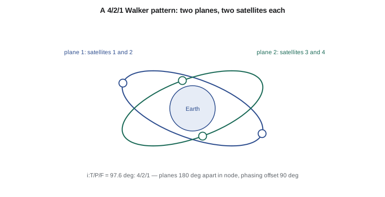
The code lists the elements of a 97.6:4/2/1 pattern for four fire-watch satellites. The two planes are 180 degrees apart in node, each satellite is 180 degrees from its partner in the same plane, and the satellites in plane 2 are offset by 90 degrees from those in plane 1. The result is a satellite crossing the equator every quarter orbit, evenly spread. For sun-synchronous orbits, planes 180 degrees apart in node share the same local time but cross it in opposite directions: plane 1 passes over at 10:30 heading south and plane 2 at 10:30 heading north. For a fire service, planes at different local times would be more useful, since fires grow in the afternoon; a mix of a 10:30 plane and a 13:30 plane is a common choice.
Other constellation patterns
Walker delta patterns, with inclined planes spread all the way around the equator, suit global coverage. Polar or streets-of-coverage patterns place planes over only half the equator, because polar planes cross at the poles and each covers both sides of the Earth. Iridium, completed in 1998 and replaced with a second generation in 2017 to 2019, uses six polar planes of eleven satellites at 780 km. Navigation systems use medium Earth orbits: GPS has satellites in six planes at about 20,200 km and 55 degrees, and Galileo uses three planes at about 23,200 km and 56 degrees. Communication megaconstellations in low orbit use many shells at different altitudes and inclinations, together numbering thousands of satellites; by 2026 SpaceX's Starlink alone had launched well over 9,000. Geostationary systems need only three satellites for nearly global coverage outside the polar regions, at the cost of the long signal delay of about a quarter of a second for a round trip.
Earth observation constellations are usually smaller and organized around revisit. Planet operates well over a hundred small imaging satellites that together image most of the land surface daily. Canada's RADARSAT Constellation Mission, launched in 2019, uses three radar satellites in the same plane, spaced to give a four-day exact repeat and daily revisit over much of Canada; the follow-on capability is under study. The European Copernicus Sentinel-2 mission uses two satellites 180 degrees apart in one plane to give a five-day revisit at the equator.
Deploying and maintaining a constellation
A rideshare can carry all the satellites of a small constellation to one plane, after which they spread out by differential phasing, using the techniques of Lesson 4: each satellite raises or lowers its orbit slightly, drifts to its slot, then returns. Some operators spread satellites along the orbit with differential drag, changing the attitude to vary the drag area, which costs no propellant at all. Different planes, however, need separate launches or a costly plane change, unless the operator waits for the natural difference in nodal regression between slightly different altitudes or inclinations to separate the planes over months. Once deployed, the satellites must be kept in formation: small differences in drag and launch dispersions would otherwise make the pattern drift apart, so each satellite carries a station-keeping budget.
| Constellation | Orbit | Pattern | Purpose |
|---|---|---|---|
| GPS | MEO, about 20,200 km, 55 deg | six planes | navigation |
| Galileo | MEO, about 23,200 km, 56 deg | three planes | navigation |
| Iridium | LEO, 780 km, polar | six planes of eleven | communication |
| RADARSAT Constellation Mission | LEO, about 600 km, sun-synchronous | three satellites, one plane | radar observation |
| Sentinel-2 | LEO, 786 km, sun-synchronous | two satellites, one plane | optical observation |
| Crocus fire-watch study | 550 km, 97.6 deg | 4/2/1 Walker | fire detection |
Worked problem
Footprint radius
Find the coverage radius at 550 km for a 5 degree elevation mask.
Show solution
- \(\sin\rho = 6378/6928 = 0.9206\), so \(\rho = 67.0^\circ\).
- \(\sin\eta = \cos 5^\circ \times 0.9206 = 0.9171\), so \(\eta = 66.5^\circ\).
- \(\lambda = 90 - 5 - 66.5 = 18.5^\circ = 0.3227\) rad; radius \(= 6378 \times 0.3227\).
Answer: About 2060 km.
Worked problem
Pass length
How long is an overhead pass with a central angle of 18.49 degrees and a 95.6 minute period?
Show solution
- The satellite covers \(2\lambda = 36.98^\circ\) of its orbit while in view.
- \(t = 95.6 \times 36.98/360\).
Answer: About 9.8 minutes.
Worked problem
Walker phasing
In a 4/2/1 pattern, what is the phase offset between adjacent planes?
Show solution
- \(F \times 360/T = 1 \times 360/4\).
Answer: 90 degrees of argument of latitude.
Common mistakes
MistakeUsing the horizon as the coverage limit.
InsteadReal stations and sensors need a minimum elevation of 5 to 10 degrees.
MistakeCounting night passes for an optical camera.
InsteadOnly daylight, cloud-free passes give optical images.
MistakeTreating mean revisit as the maximum gap.
InsteadGaps vary; simulate the constellation over weeks.
MistakeAssuming one rideshare can populate several planes.
InsteadPlane changes are expensive; use separate launches or wait for differential regression.
MistakeForgetting station-keeping for a constellation.
InsteadDifferences in drag make the pattern drift without correction.
Summary and key terms
- Constellations meet needs a single satellite cannot.
- Coverage geometry gives the footprint from altitude and minimum elevation: at 550 km with a 5 degree mask, a circle of about 2060 km radius and passes of up to 9.8 minutes.
- Off-nadir pointing widens the accessible strip, and revisit falls roughly in proportion to the number of satellites.
- Walker delta patterns \(i: T/P/F\) define a constellation with a few integers.
- Real constellations range from three radar satellites to thousands of communication satellites, and they must be deployed by phasing and maintained by station-keeping.
- Constellation
- A group of satellites in coordinated orbits.
- Elevation mask
- The minimum elevation at which a target or station sees a satellite.
- Earth central angle
- The angle at the Earth center between the sub-satellite point and the edge of coverage.
- Revisit time
- The interval between successive observation opportunities of a target.
- Walker delta pattern
- A constellation \(i: T/P/F\) of equally spaced planes and satellites.
- Phasing parameter
- The integer that sets the offset between satellites in adjacent planes.
- Differential drag
- Using attitude changes to vary drag and adjust spacing without propellant.
- Megaconstellation
- A constellation of hundreds to thousands of satellites.
Practice problems
Work each problem on paper first, then reveal the answer to check.
What is the limb angle at 550 km?
Show answer
About 67.0 degrees.
How long is an overhead pass with a 5 degree mask?
Show answer
About 9.8 minutes.
What does \(F\) control in a Walker pattern?
Show answer
The phase offset between satellites in adjacent planes.
Why do night passes not help an optical camera?
Show answer
It needs reflected sunlight.
How many satellites does Sentinel-2 use?
Show answer
Two, in one plane, 180 degrees apart.
How can satellites spread along an orbit without propellant?
Show answer
By differential drag.
Lesson quiz · 5 questions
Score 60% or more to complete this lesson.
Create a free account to save your progress, take quizzes and earn a certificate.