
PHOT-311 · Lesson 10 of 12 · 25 min
Drones and aerial views of property
Aerial images show what ground-level photographs cannot: the shape of a roof, the layout of a site, the relationship of a building to its streets, parks, water and neighbours, and the size of a lot. Drones have made aerial work affordable, and aerial views are now standard in real estate, construction progress, campus and resort photography and many architectural commissions. Flying a drone for business is regulated aviation, however, with rules on pilot certification, registration, airspace, distances from people and privacy. This lesson covers aerial composition and technique and the legal framework in Canada and the United States.
What aerial views add
- Context: the building in its neighbourhood, the approach roads and nearby amenities such as schools, parks or a lake.
- Site and lot: boundaries, landscaping, driveways, outbuildings and the orientation of the property.
- Roofs and massing: green roofs, solar arrays and roof terraces that cannot be seen from the ground.
- Construction progress: regular, repeatable views of a site from fixed positions, and mapping for quantities.
- Elevated eye-level views: a drone at 5 to 15 m height can act as a very tall tripod, giving a slightly elevated view of a facade with less need for rise and no converging verticals.
Composition from the air
Aerial images follow the same principles as ground images, with a few additions.
- Oblique views, with the camera tilted down 20° to 45°, show the building's facades and roof together with its context; they are the most useful for real estate and most architecture.
- Top-down (nadir) views, with the camera pointing straight down, show plans, patterns and site layouts graphically, like a drawing.
- Low elevated views, at a height of roughly one or two storeys, show facades with almost no convergence and are excellent for buildings on tight sites.
- Height matters: too high and the building becomes a small object in a map; too low and context disappears. For a typical house, 25 to 60 m is common for obliques.
- Converging verticals appear whenever the camera tilts down; for elevated facade views, keep the camera level, or correct in software (lesson 3).
- The sun matters from the air too: low side light shows the topography and textures of landscapes, and midday sun shows roofs evenly.
Worked problem
How much ground does a top-down view cover?
A drone camera has a horizontal angle of view of 73° and a 4:3 sensor. Flying at 60 m above level ground, pointing straight down, how wide and deep is the area covered? At what height would a 40 m wide lot fill the frame width?
Show solution
- Width = 2 × 60 × tan(36.5°) = 120 × 0.740 ≈ 89 m.
- Depth at 4:3 = 89 × 3 / 4 ≈ 67 m.
- For a 40 m width: h = 40 / (2 × 0.740) ≈ 27 m.
Answer: About 89 m by 67 m at 60 m height. A height of about 27 m frames a 40 m lot edge to edge, so 35 to 40 m leaves margins.
Equipment and technique
Camera drones for property work typically weigh between about 250 g and 1 kg and carry stabilized cameras with one-inch or larger sensors, raw capture and automatic exposure bracketing. Larger drones carry interchangeable-lens cameras for high-end architecture and film work.
- Shoot raw and bracket; skies and shaded facades often need blending, as on the ground.
- Use polarizing and neutral density filters for glare and for smooth video at appropriate shutter speeds.
- Plan flights in advance with mapping apps, noting obstacles, trees, power lines and wind.
- Fly smoothly for video: slow, steady movements, reveals and orbits at constant speed.
- Watch batteries closely, especially in cold weather, when capacity drops sharply. Carry spares and land with reserve power.
- Check for magnetic and radio interference near steel structures, power lines and towers.
The law: who may fly and where
In both countries, drone rules are set by the national aviation regulator, and they apply to commercial and recreational pilots alike, though commercial use brings additional obligations in the United States. The rules change regularly; always check the current regulations and airspace before every flight.
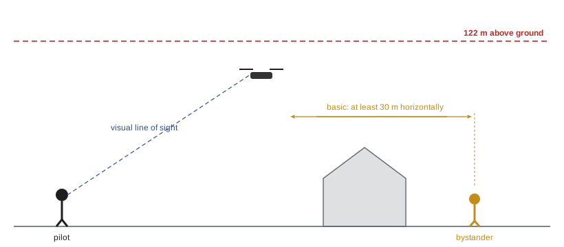
In Canada, Transport Canada regulates drones under Part IX of the Canadian Aviation Regulations. Drones weighing from 250 g up to 25 kg must be registered and marked with their registration number, and the pilot must hold a drone pilot certificate. A basic certificate, earned by passing an online exam, allows basic operations: in uncontrolled airspace, at least 30 m horizontally from bystanders and never over them. An advanced certificate, requiring a more difficult exam and a flight review, allows advanced operations: in controlled airspace with an RPAS flight authorization from NAV CANADA, and near or over bystanders with a drone whose manufacturer has declared it suitable. All operations must stay within visual line of sight and below 122 m above ground, away from aircraft, airports and heliports as the rules require, and away from emergency operations and advertised events unless specially authorized. Amendments that took effect on 4 November 2025 added a Level 1 Complex certificate and an operator certificate for some low-risk flights beyond visual line of sight and for medium drones; most property photography still uses basic or advanced operations. Drones under 250 g do not need registration or a certificate, but pilots must not fly them in a way that endangers aviation or people.
Other laws apply on top of aviation rules: trespass and nuisance, municipal rules for launching from parks, provincial or state privacy laws, wildlife protection and rules in national parks, where drone flights are often banned or need a permit.
Privacy and neighbours
A drone over a property inevitably sees neighbours' yards, pools and windows. Plan flights to keep the camera on the subject property, avoid hovering over neighbouring homes, and do not publish images that reveal identifiable people in private spaces. In Canada, privacy torts recognized in several provinces and statutory privacy acts in British Columbia, Saskatchewan, Manitoba and Newfoundland and Labrador, along with Quebec's Civil Code, protect against intrusions; in the United States, state laws on privacy, trespass and drone use vary, and some states have specific drone privacy statutes. Talk to neighbours where practical; a friendly explanation prevents many complaints.
Insurance and operations manuals
Professional drone pilots carry aviation liability insurance; many clients and venues require proof of coverage, often of two million dollars or more. General business liability policies usually exclude aircraft, including drones. Keep flight logs, maintenance records, checklists and a written operations manual: they demonstrate professionalism and support any claim or regulatory inquiry.
A pre-flight checklist
- Check regulations, airspace maps and any notices for temporary restrictions.
- Confirm authorization if in controlled airspace.
- Check weather: wind, gusts, precipitation and temperature.
- Survey the site for obstacles, people, animals and launch and landing areas.
- Inspect the drone, propellers, batteries and controller; calibrate the compass if needed.
- Brief any visual observer and set up the area to keep bystanders at a safe distance.
- Plan the shots and the sequence to make the best use of battery time.
- After the flight, log the flight, inspect the drone and charge batteries correctly.
| Topic | Canada (Transport Canada) |
|---|---|
| Pilot credential | Basic or advanced pilot certificate |
| Registration | 250 g to 25 kg drones |
| Height limit | 122 m above ground |
| Bystanders | Basic: 30 m horizontally, never over; advanced: closer with suitable drone |
| Controlled airspace | Advanced certificate and NAV CANADA authorization |
| Broadcast identification | Not required for small drones at present |
Construction progress from the air
Drones have transformed construction progress photography. A drone can photograph a site from the same positions and heights every week or month, building a visual record that owners, lenders and contractors use to track progress and resolve disputes. Automated flight apps can repeat a planned route exactly. Photogrammetry software can turn overlapping images into orthomosaic maps and 3-D models from which volumes, such as stockpiles of earth, and distances can be measured. Such mapping work often requires additional training and, for accurate measurements, ground control points surveyed into a coordinate system.
Elevated views without a drone
Not every elevated view needs a drone. Telescopic masts carrying a camera to 6 to 15 m give stable, high-quality elevated views with full control of exposure and composition, without aviation rules, and can be used in places where drones are restricted, such as near airports or in dense city centres. Neighbouring buildings, parking structures and hills can also provide vantage points with the owner's permission. A mast or a borrowed balcony is often faster and cheaper than a drone flight in controlled airspace.
Planning the shot list for aerial work
Aerial shoots work best with a written shot list: the views, heights and directions needed, the order in which they will be flown and the light they need. Group views by direction relative to the sun, as on the ground. Start with the most important views while batteries are fresh and the light is right, and leave video moves, which consume battery quickly, until after the stills are secured. Note any views that cannot be flown legally, such as those requiring flight over bystanders without the right certificate or authorization, and plan alternatives.
Video from the air
Aerial video adds movement and drama to property marketing, but it must be smooth and purposeful. Common moves include a slow reveal rising over a tree line, a steady push toward the front of a house, a sideways track along a facade and a slow orbit around the building. Fly each move several times, at a constant speed, and shoot at a frame rate and shutter speed suited to the delivery format, using neutral density filters to keep the shutter at about twice the frame rate for natural motion blur. Avoid fast spins and rapid altitude changes, which look amateurish and can make viewers uncomfortable.
Weather and flying conditions
Wind is the main weather limit for small drones. Many consumer drones can fly in winds of 30 to 40 km/h, but gusts, turbulence around buildings and stronger winds aloft make control difficult and drain batteries quickly. Rain and snow can damage drones that are not weather-sealed. Cold reduces battery performance and can cause sudden power loss. Heat can overheat batteries and electronics. Check the forecast for wind at altitude, not just at ground level, and set personal limits more conservative than the manufacturer's maximums.
Building an aerial practice
Many architectural and real estate photographers add drone work gradually. They first earn the basic credential, practise in open areas away from people, then take on simple real estate jobs in uncontrolled airspace before pursuing advanced certification and more complex work. Keeping records, joining professional associations and staying current with regulatory changes are part of professional practice. Regulators publish updates and notices regularly, and the rules described in this lesson will continue to evolve.
Aerial images and accuracy
Aerial views can also mislead. A wide-angle aerial may make a lot look larger than it is, or hide a nearby highway, rail line or industrial site that a buyer would care about. Lot lines drawn on aerial images must be approximate unless based on a survey, and should be labelled as such. As with ground images, the honest test applies: when buyers visit, the property and its surroundings should match what the aerial images led them to expect.
Common mistakes
MistakeFlying for a client without the required certificate.
InsteadHold the correct pilot credential and register the drone.
MistakeAssuming a small drone may fly anywhere.
InsteadCheck airspace, parks rules and local restrictions before every flight.
MistakeHovering over neighbours' yards.
InsteadKeep the camera on the subject property and respect privacy.
MistakeRelying on general business insurance.
InsteadCarry aviation liability coverage for drones.
MistakeFlying in the cold with one battery.
InsteadWarm and carry spare batteries and land with reserve power.
Summary and key terms
- Aerial images show context, sites, roofs and progress that ground images cannot.
- Oblique views are most useful; top-down views show plans; low elevated views keep verticals straight.
- Ground coverage of a top-down view is \( 2h \tan(\theta / 2) \) across the frame.
- Shoot raw, bracket, plan flights and manage batteries carefully.
- Canada regulates drones through Transport Canada's Part IX; the US through FAA Part 107.
- Certification, registration, height limits, bystander rules and airspace authorization apply.
- Privacy, trespass, insurance and records matter as much as flying skill.
Practice problems
Work each problem on paper first, then reveal the answer to check.
Name two things aerial views show that ground views cannot.
Show answer
Roofs, site layout, context, lot size or progress.
Coverage width at 40 m height with a 73° lens?
Show answer
2 × 40 × 0.74 ≈ 59 m.
Which aerial view looks most like a plan?
Show answer
A top-down (nadir) view.
Maximum height for small drones in Canada?
Show answer
122 m above ground.
What distance from bystanders applies to basic operations?
Show answer
At least 30 m horizontally, never over them.
What do you need for controlled airspace in Canada?
Show answer
An advanced certificate and NAV CANADA authorization.
Why do batteries need extra care in winter?
Show answer
Cold reduces capacity sharply.
Why talk to neighbours before flying?
Show answer
To address privacy concerns and avoid complaints.
What insurance do drone pilots need?
Show answer
Aviation liability insurance; general policies often exclude drones.
Name three items on a pre-flight checklist.
Show answer
Airspace, weather, site survey, drone inspection, observer briefing.
Lesson quiz · 5 questions
Score 60% or more to complete this lesson.
Create a free account to save your progress, take quizzes and earn a certificate.