
GEOM-340 · Lesson 1 of 12 · 25 min
Why projections distort
When the irrigation district's GIS went into service, Ruth Albrecht noticed that the same question kept arriving at Coulee Geomatics in different forms. The district's engineer wanted to know why the length of Lateral 7 in the GIS was 0.3 m shorter per kilometre than the length his crew had chained. A contractor asked whether the coordinates on the 1958 as-built drawings, the coordinates in the GIS and the coordinates on Grant's control sheets could be mixed in one design file. A landowner's lawyer asked why the area of a quarter section on the provincial parcel map differed from the area on the title. Each question had the same root: the Earth is curved and the maps, drawings and screens on which its features are measured are flat. Ruth asked Leah Tran to prepare a short course for the district's staff and the firm's new hires, and this course follows that work. It begins with the fact that makes the subject necessary: a curved surface cannot be laid flat without stretching or tearing it.
The orange peel problem
Peel an orange and try to press the peel flat on a table. However carefully it is done, the peel either splits or stretches: the middle of each piece lies flat while the edges gape or wrinkle. A sphere and a plane have different intrinsic geometry. On a plane the angles of a triangle add to 180°, the circumference of a circle is \(2\pi\) times its radius and parallel lines never meet. On a sphere the angles of a triangle add to more than 180°, by an amount proportional to its area; a circle drawn on the surface has a circumference less than \(2\pi\) times its radius measured along the surface; and the 'straight lines' of the surface, the great circles, always meet. These differences are properties of the surface itself, measurable by someone who never leaves it.
Carl Friedrich Gauss proved in 1827 that this intrinsic curvature cannot be changed by bending a surface without stretching it. A sheet of paper can be rolled into a cylinder or a cone because both have zero intrinsic curvature, the same as the plane; it cannot be wrapped smoothly around a ball. The Earth's surface, approximated by a sphere or an ellipsoid, has positive curvature everywhere. It follows that every flat map of any part of it must change some distances. The change can be kept small over a small area, it can be arranged so that some property is kept exactly, and it can be placed where it does least harm, but it cannot be removed. Map projection is the craft of deciding where the distortion goes.
What a map projection is
A map projection is a mathematical rule that assigns plane coordinates \((x, y)\), usually called easting and northing, to every point of latitude \(\varphi\) and longitude \(\lambda\) on a reference surface:
together with the inverse rule that recovers latitude and longitude from the plane coordinates. The word 'projection' suggests light shining through a globe onto a screen, and a few projections can be built that way, but most are defined by formulas chosen to give the map a desired property. The functions work on geodetic latitude and longitude on an ellipsoid, the surface introduced in Geodesy I. A complete projected coordinate reference system therefore has several parts: a geodetic datum and its ellipsoid, which fix where latitude and longitude are; a projection method with its parameters, such as a central meridian and a scale factor; a false easting and false northing that keep coordinates positive; a unit of length; and the order and direction of the axes. Leaving out any of these is the source of most coordinate mistakes, and later lessons treat each in turn.
It helps to separate three ideas that are often blurred. A datum, such as NAD83(CSRS) or NAD83(2011), says which ellipsoid is used and how it is placed relative to the Earth. A projection, such as transverse Mercator, is a formula that flattens that ellipsoid. A coordinate system for a particular region, such as UTM zone 12 or a state plane zone, is a projection with chosen parameters, applied to a stated datum. Changing the datum moves points by centimetres to tens of metres; changing the projection changes the numbers completely while the points stay where they are.
What can be preserved
Because a flat map cannot keep all distances, projection designers choose which properties to keep. The four classical properties are these. A conformal projection keeps angles, and therefore the shapes of small features, correct at every point: the scale may differ from place to place, but at any one point it is the same in every direction. An equal-area (equivalent) projection keeps areas in correct proportion everywhere, at the cost of angles and shapes. An equidistant projection keeps true scale along a particular set of lines, such as all meridians, or all straight lines through one centre point. An azimuthal projection keeps the directions, or azimuths, from one central point true.
No projection can be both conformal and equal-area; that would make it an exact copy of the curved surface, which Gauss showed is impossible. Some projections are compromises that are neither, chosen because they look balanced on world maps. For surveying and engineering the choice is nearly always conformal, because survey measurements are angles and distances made over short lines, and a conformal projection lets an angle measured on the ground be used on the map unchanged, with a single scale factor at each point correcting all the distances. Equal-area projections are used for statistical and thematic maps where area comparisons matter, such as maps of irrigated area or land cover by county or municipal district.
| Property | What is kept | What is given up | Typical use |
|---|---|---|---|
| Conformal | Angles and local shape | Area, over large regions | Surveying, engineering, navigation, topographic maps |
| Equal-area | Relative area | Angles and shape | Thematic and statistical maps, area analysis |
| Equidistant | Scale along chosen lines | Both area and angle elsewhere | Distance maps, range rings, small atlases |
| Azimuthal | Directions from a centre | Depends on the variant | Polar maps, radio coverage, air routes |
| Compromise | None exactly | A little of everything | World maps for general display |
Developable surfaces, aspects and secant forms
Many projections are easiest to picture by imagining the globe wrapped in a surface that can be unrolled flat, a developable surface. A cylinder gives cylindrical projections, in which meridians are equally spaced parallel lines and parallels are straight lines at right angles to them. A cone gives conic projections, in which meridians are straight lines converging to a point and parallels are arcs of circles. A plane gives azimuthal projections, in which meridians radiate from a centre and directions from that centre are true. In each case the distortion is zero where the surface touches the globe and grows away from it.
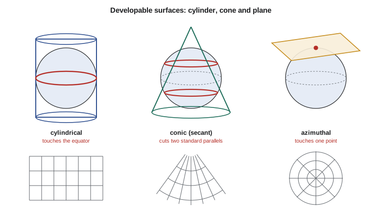
The surface can touch the globe along one line, the tangent case, or cut through it along two lines, the secant case. A secant surface lies partly inside and partly outside the globe; features between the two lines of contact are drawn slightly too small and features outside them slightly too large. Spreading the error both ways halves the largest error for a given width of map, which is why most coordinate systems used in surveying are secant, or are tangent with the scale on the central line reduced slightly below one, which has the same effect. The orientation of the surface is called the aspect. In the normal aspect a cylinder touches the equator; in the transverse aspect it is turned through 90° to touch a meridian, giving the transverse Mercator projection of lesson 6; in an oblique aspect it touches some other great circle. Aspect changes the pattern of distortion but not the property kept.
Distortion grows with the size of the area
The code below puts numbers on these ideas. Its first part uses the simplest of all flat maps, the plate carrée, which plots longitude and latitude directly as \(x\) and \(y\). At the equator a degree of longitude and a degree of latitude are both about 111 km, so the map is nearly true there. At the district's latitude a degree of longitude is much shorter on the ground, but the map draws it the same length as a degree of latitude, so every east-west distance is stretched. The second part shows how fast distortion grows with the size of the mapped area for the best possible plane: the error grows with the square of the distance from the centre. The third computes the spherical excess of a large triangle, a direct measurement of curvature.
import math
R = 6371000.0          # mean radius of a spherical Earth, m

# 1. The simplest flat map: plot longitude and latitude as x and y
#    (plate carree, one map unit = one degree on the equator).
print("Plate carree: map length of 1 km east-west, compared with the truth")
deg = R * math.pi / 180        # ground length of one degree on the equator
for lat in (0, 30, 45, 49.7, 60, 80):
    true_deg_lon = deg * math.cos(math.radians(lat))   # ground length of 1 degree of longitude
    k = deg / true_deg_lon                              # east-west scale on the map
    print(f"  latitude {lat:5.1f}: one degree of longitude = {true_deg_lon/1000:7.2f} km, "
          f"east-west scale = {k:5.3f}, a 1 km road is drawn {k:5.3f} km long")

# 2. A flat plane touching the sphere: how much does any plane map
#    get wrong at distance d from its point of contact?
print("\nBest plane touching the sphere: scale error grows with the square of size")
for name, d in (("one field", 0.8e3), ("the district", 15e3), ("a county", 60e3),
                ("southern Alberta", 300e3), ("North America", 3000e3)):
    err = (d / R) ** 2 / 4          # about half of the full spread d^2 / (2 R^2)
    print(f"  {name:17s} half-width {d/1000:7.1f} km -> scale error about {err*1e6:10.2f} ppm "
          f"({err*1000:8.3f} m per km)")

# 3. Gauss: the angles of a triangle drawn on the sphere add to more than 180 degrees
a = 300e3                           # side of an equilateral triangle on the ground, m
area_flat = math.sqrt(3) / 4 * a**2
excess = area_flat / R**2           # spherical excess in radians, approximately area / R^2
print(f"\nEquilateral triangle with {a/1000:.0f} km sides: angle sum = 180 deg + "
f"{math.degrees(excess)*3600:.1f} arc seconds")Plate carree: map length of 1 km east-west, compared with the truth latitude 0.0: one degree of longitude = 111.19 km, east-west scale = 1.000, a 1 km road is drawn 1.000 km long latitude 30.0: one degree of longitude = 96.30 km, east-west scale = 1.155, a 1 km road is drawn 1.155 km long latitude 45.0: one degree of longitude = 78.63 km, east-west scale = 1.414, a 1 km road is drawn 1.414 km long latitude 49.7: one degree of longitude = 71.92 km, east-west scale = 1.546, a 1 km road is drawn 1.546 km long latitude 60.0: one degree of longitude = 55.60 km, east-west scale = 2.000, a 1 km road is drawn 2.000 km long latitude 80.0: one degree of longitude = 19.31 km, east-west scale = 5.759, a 1 km road is drawn 5.759 km long Best plane touching the sphere: scale error grows with the square of size one field half-width 0.8 km -> scale error about 0.00 ppm ( 0.000 m per km) the district half-width 15.0 km -> scale error about 1.39 ppm ( 0.001 m per km) a county half-width 60.0 km -> scale error about 22.17 ppm ( 0.022 m per km) southern Alberta half-width 300.0 km -> scale error about 554.33 ppm ( 0.554 m per km) North America half-width 3000.0 km -> scale error about 55432.86 ppm ( 55.433 m per km) Equilateral triangle with 300 km sides: angle sum = 180 deg + 198.0 arc seconds
At latitude 49.7°, the plate carrée draws a 1 km road running east-west 1.546 km long, a 55 % error, while a road running north-south is drawn correctly. This is why a GIS that displays data in latitude and longitude makes Alberta look wide and squat, and why any distance or area measured in such a display is wrong. The second table is more encouraging for engineers: a plane touching the Earth at the centre of the district has a scale error of about 1.4 parts per million at its edge, 15 km away, which is 1.4 mm per kilometre and smaller than the error of most measurements. Over a county the error reaches tens of parts per million, over southern Alberta hundreds, and over a continent tens of thousands. The 300 km triangle's angles add to 180° plus 198 seconds of arc, a quantity that a good total station can detect over long sights and that early geodetic surveys corrected routinely.
The square law has a practical meaning. Doubling the width of a projection zone quadruples its largest distortion. A coordinate system for a whole province or state must therefore accept distortions of a few hundred parts per million, while a system designed for one county or one project can hold distortion to a few parts per million. Much of this course is about that trade-off: wide systems are convenient because everyone shares them, narrow systems are accurate because they fit the ground, and the surveyor's task is to know which is in use and to correct for it.
Distortion that is not from the projection
Two other effects add to the projection's distortion and are often confused with it. The first is height. Projections flatten the ellipsoid, not the ground, and the ground at the district stands roughly 900 to 1,000 m above the ellipsoid. A distance measured on the ground is longer than the same distance reduced to the ellipsoid by about one part in 7,000, or 140 parts per million, at these heights. Lesson 8 combines this with the projection's scale into a single combined factor. The second is the datum: coordinates of the same point in two datums differ by a shift that has nothing to do with flattening. Lessons 9 and 10 deal with datum transformations and with coordinates that change over time.
There is also the distortion of measurement and display. A paper map printed at 1:50,000 shrinks and swells with humidity by more than a projection distorts over the same sheet; a scanned drawing carries the distortions of the scanner; and a screen shows whatever the GIS has been told the coordinates mean. These are reasons to keep coordinates as numbers in a well-defined system and to treat every picture of them as approximate.
Choosing a projection
The choice of projection follows from four questions. What property matters for the use: shapes and angles for surveying and engineering, areas for statistics, distances or directions from a point for coverage maps? How large is the area, and what is its shape: a region long in the east-west direction suits a conic or a normal cylindrical projection, one long north-south suits a transverse cylinder, and a compact region suits an azimuthal projection or any of them? Where is it: near the equator, at middle latitudes or near a pole? And who else will use the data: a project coordinate system that matches the ground is no help if every other agency publishes in a different one, and a widely shared system is no help if its distortion is too large for the work.
For the district, Leah's answers were straightforward. The GIS master data stayed in UTM zone 12 on NAD83(CSRS), the system already used for its imagery and most provincial data, because the GIS is used for planning and display where a few hundred parts per million do not matter. Engineering and construction work, where staking must agree with chained or measured distances, would use a projection that fits the district's ground, as lessons 7 and 8 explain. And thematic maps of irrigated area for the annual report would use an equal-area projection so that the areas compared on the page are correct. One set of data, three projections, each chosen for its purpose, and transformations among them handled by the software of lesson 11.
Worked problem
How large a plane can be used without correction?
A construction project wants to treat its site as flat, using distances on the ground as plane distances, and will accept a scale error of 10 parts per million from curvature alone. Using the approximation that a well-placed plane's scale error at distance \(d\) from its centre is about \(d^2 / (4R^2)\), how far from the centre may the site extend?
Show solution
- \[\frac{d^2}{4R^2} \le 10 \times 10^{-6}\]
- \[d \le 2R\sqrt{10^{-5}} = 2 \times 6371 \text{ km} \times 0.00316 = 40.3 \text{ km}\]
Answer: About 40 km from the centre, or a site 80 km across. Curvature is rarely the limiting factor for a single project; height above the ellipsoid, at 140 ppm for 900 m, is a much larger effect and must be handled by the choice of projection scale, as lesson 8 shows.
Common mistakes
MistakeTreating a map projection and a datum as the same thing.
InsteadThe datum places the ellipsoid; the projection flattens it. Both must be stated.
MistakeMeasuring distances or areas on data displayed in latitude and longitude.
InsteadMeasure in a projected system suited to the area, or use geodesic calculations.
MistakeAssuming a projection can be both conformal and equal-area.
InsteadChoose the property that matters: conformal for survey work, equal-area for area statistics.
MistakeUsing a provincial or state-wide system as if its distances were ground distances.
InsteadApply the projection scale and the height factor, or use a low-distortion projection.
MistakeForgetting that distortion grows with the square of the area's width.
InsteadSmall zones can be very accurate; large zones need corrections.
Summary and key terms
- A curved surface cannot be flattened without distortion (Gauss, 1827); every map projection changes some distances.
- A projection is a pair of formulas from latitude and longitude to easting and northing, applied to a stated datum and ellipsoid.
- A projected CRS needs a datum, a projection method and parameters, false origin, unit and axis order.
- Projections can be conformal, equal-area, equidistant or azimuthal; none is both conformal and equal-area.
- Cylinders, cones and planes give cylindrical, conic and azimuthal projections; secant forms spread error both ways.
- Distortion grows with the square of the distance from the line of zero distortion.
- Height above the ellipsoid and datum differences are separate effects from projection distortion.
- Map projection
- A rule assigning plane coordinates to latitude and longitude on a reference surface.
- Projected CRS
- A datum plus a projection with parameters, false origin, unit and axes.
- Conformal
- Keeping angles and local shapes true at every point.
- Equal-area
- Keeping areas in true proportion everywhere.
- Developable surface
- A surface, such as a cylinder or cone, that can be unrolled flat without stretching.
- Secant projection
- One whose surface cuts the globe along two lines of zero distortion.
- Aspect
- The orientation of the projection surface: normal, transverse or oblique.
- Spherical excess
- The amount by which the angles of a triangle on a sphere exceed 180 degrees.
Practice problems
Work each problem on paper first, then reveal the answer to check.
At what latitude does the plate carrée draw east-west distances twice their true length?
Show answer
Where \(\sec\varphi = 2\), at 60°.
Which property should a projection for a staking plan have, and why?
Show answer
Conformal, so measured angles carry over unchanged and one scale factor corrects distances at each point.
A zone's half-width is increased from 100 km to 200 km. By about what factor does its largest distortion grow?
Show answer
About four, since distortion grows with the square of the distance.
Name the parts of a projected CRS definition.
Show answer
Datum and ellipsoid, projection method and parameters, false easting and northing, unit, and axis order.
Why is a secant projection preferred to a tangent one for a zone of given width?
Show answer
Its errors are spread above and below one, halving the largest error.
Lesson quiz · 5 questions
Score 60% or more to complete this lesson.
Create a free account to save your progress, take quizzes and earn a certificate.