
ARCH-120 · Lesson 10 of 12 · 26 min
The Americas before contact
For this lesson Dr. Brandt invites a guest, Marie Beaulieu, a Métis architect who practises in Winnipeg and teaches part time at Elmhurst. She begins by asking the students where they are sitting. 'Kestrel Point and this school are on Treaty 1 territory,' she says, 'the traditional lands of the Anishinaabe, Cree, Oji-Cree, Dakota and Dene peoples and the homeland of the Red River Métis. People built here for thousands of years before any of the buildings you have studied in Europe were begun.' She sets out three objects on the table: a strip of birchbark, a cedar plank and a block of compacted snow in a cooler. 'Each of these is a building material,' she says, 'and each one carries a whole way of living. Today I want you to study these architectures as you studied the Parthenon: carefully, accurately and on their own terms. And remember that most of them belong to nations that are still here.'
Many independent beginnings
People have lived in the Americas for at least fifteen thousand years, and some evidence suggests longer. Over that time they developed hundreds of distinct nations, languages and building traditions, entirely independently of Europe, Africa and Asia. Farming began independently in Mesoamerica, the Andes and eastern North America, and cities, states, monumental architecture and sophisticated astronomy developed in several regions. The phrase before contact refers to the time before sustained European arrival from 1492 onward, which brought epidemic disease, conquest and colonization that devastated many communities. It is a convenience of periodization, not a claim that these cultures ended; many of the traditions in this lesson continue today.
This lesson looks at three broad regions: Mesoamerica (present-day Mexico and Central America), the Andes of South America, and North America, including the lands that are now the United States and Canada. Within each, building responded closely to climate and material: stone and lime plaster in Mesoamerica, finely fitted stone and earth in the Andes, and in North America earth, timber, bark, hides, adobe, stone, sod and snow.
Mesoamerica
The Olmec of the Gulf Coast of Mexico, from about 1200 to 400 BCE, built ceremonial centres of earth platforms and plazas at San Lorenzo and La Venta, with colossal carved stone heads. Their successors created some of the largest cities in the world. Teotihuacan, in the Valley of Mexico, flourished from about 100 BCE to 550 CE and may have had a hundred thousand inhabitants at its height. It was laid out on a grid oriented about 15.5 degrees east of north, along a ceremonial axis now called the Avenue of the Dead, more than 2 km (1.2 mi) long. The Pyramid of the Sun, built about 200 CE, has a base about 220 m (720 ft) square, close to that of the Great Pyramid of Giza, though it is about half as tall. Its form echoes the mountains behind it. Its terraces were built in the talud-tablero style, a sloping apron (talud) below a vertical framed panel (tablero), which became a widespread Mesoamerican motif.
The Classic Maya, from about 250 to 900 CE, built city-states in the lowlands of southern Mexico, Guatemala and Belize, with temple pyramids, palaces, ball courts and causeways, all of limestone covered with painted lime plaster. Maya builders used the corbelled vault, which limited room widths, so their temples have small rooms and very thick walls; their height and mass were directed outward to the plazas, where ceremonies took place. Tall roof combs on top of the temples increased their height. At Tikal, Temple I was built about 732 to 734 CE as the funerary temple of the ruler Jasaw Chan K'awiil I. At Palenque, the Temple of the Inscriptions, completed after 683 CE, covers the tomb of the ruler K'inich Janaab' Pakal, reached by a hidden stairway discovered in 1952.
Mesoamerican architecture was closely tied to the calendar and the sky. At Chichén Itzá in Yucatán, the pyramid called El Castillo (the Temple of Kukulcán), built between the ninth and twelfth centuries, has stairways on four sides; around the equinoxes, in the late afternoon, the setting sun casts a pattern of triangles along the edge of the north stairway that resembles a serpent descending to the carved serpent head at its base. The Mexica (Aztec) capital, Tenochtitlan, founded in 1325 on an island in Lake Texcoco, was a city of canals, causeways and chinampas (raised garden plots), centred on the twin-temple Templo Mayor. Its remains lie beneath present-day Mexico City.
The Andes
In the Andes, monumental architecture began remarkably early. At Caral, in the Supe valley of Peru, people built platform mounds and sunken circular plazas about 2600 BCE, at about the same time as the pyramids of Giza. Later cultures such as Chavín, Moche, Nazca, Tiwanaku and Chimú built temples, cities and huge adobe complexes; Chan Chan, the Chimú capital near the coast, was among the largest adobe cities in the world.
The Inca state, which expanded rapidly in the fifteenth century under Pachacuti and his successors, built a road network, the Qhapaq Ñan, of about 30,000 km (18,600 mi) along the Andes, with way stations, storehouses and suspension bridges of woven grass. One such bridge, Q'eswachaka in Peru, is still rewoven every year by local communities. Inca masons were famous for their ashlar walls, in which blocks of stone, some polygonal with many sides, were shaped by pounding with harder hammerstones and fitted so tightly without mortar that a knife blade cannot be pushed between them. Walls lean slightly inward, and doors, windows and niches are trapezoidal, narrower at the top. These features made the walls highly resistant to earthquakes: blocks can shift slightly and settle back into place.
Machu Picchu, built about 1450 as a royal estate for Pachacuti on a ridge above the Urubamba River, combines fine ashlar temples with terraces that stabilize the steep slopes and support farming, a drainage system beneath them and buildings aligned with the solstice sunrise. The Inca capital, Cusco, was laid out with its central plaza and temple, the Qorikancha, from which lines called ceques radiated toward shrines in the landscape. After the Spanish conquest, the Church of Santo Domingo was built on the Qorikancha's walls; in earthquakes in 1650 and 1950, the colonial church was damaged while the Inca walls held.
North America: mounds and cities
In eastern North America, people built earthworks for thousands of years. Watson Brake in present-day Louisiana, a ring of eleven mounds joined by a ridge, was built about 3500 BCE, older than Stonehenge or the pyramids of Egypt, by people who lived by hunting, fishing and gathering. Poverty Point, also in Louisiana, built about 1700 to 1100 BCE, consists of six concentric C-shaped ridges facing a bayou and several large mounds. Later, the Hopewell cultures of the Ohio valley (about 1 to 400 CE) built vast geometric earthworks of circles, squares and octagons. The Newark Earthworks in Ohio, which include an octagon connected to a circle, are aligned with the 18.6-year cycle of the moon's rising and setting points.
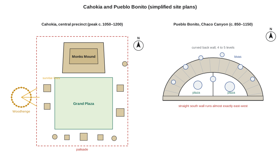
Cahokia, near present-day St. Louis on the Mississippi River, was the largest city north of Mesoamerica before the eighteenth century. It grew rapidly after about 1050 CE, and at its peak, roughly 1050 to 1200, it may have had an estimated ten thousand to twenty thousand people, with more in the surrounding region. Its builders raised about 120 earthen mounds. The largest, Monks Mound, is about 30 m (100 ft) high on a base of about 290 by 240 m (955 by 775 ft), built in stages from basketloads of earth carried by hand, and carried a large timber building on its summit. In front of it was the Grand Plaza, a levelled open space of about 20 hectares (50 acres). Rings of tall wooden posts, now called Woodhenge, marked the positions of sunrise at the solstices and equinoxes. Cahokia declined after about 1200 and was largely abandoned by 1350. It is a UNESCO World Heritage Site, as are Poverty Point, Chaco and the Hopewell earthworks.
The Ancestral Puebloans
In the dry Four Corners region of the southwestern United States, the Ancestral Puebloans built in stone and adobe. In Chaco Canyon, New Mexico, between about 850 and 1150, they built a dozen great houses, large multi-storey buildings with hundreds of rooms, connected by roads that ran straight for many kilometres across the desert. Pueblo Bonito, the largest, is a D-shaped complex of more than six hundred rooms, rising to four or five storeys at its curved back wall and stepping down to a single storey along its straight south wall, which runs almost exactly east-west. Within it are dozens of kivas, circular rooms often set partly underground, used for ceremony and community gatherings; the largest are great kivas.
Chacoan walls were built with a rubble core faced with thin, finely laid sandstone slabs in banded patterns, and the floors and roofs were framed with timbers carried from mountains up to about 80 km (50 mi) away, an enormous effort in a land without draft animals or wheeled vehicles. Several Chacoan buildings are aligned with the sun and moon. On Fajada Butte, a spiral petroglyph is crossed by daggers of sunlight passing between stone slabs at the solstices and equinoxes, and some great houses are oriented toward the lunar standstill positions. Pueblo Bonito's south-facing terraces caught the low winter sun, and its thick masonry walls stored heat, a passive solar strategy studied by designers today.
Later, around 1190 to 1280, Ancestral Puebloan communities at Mesa Verde, in southwestern Colorado, built villages of stone in alcoves in the cliffs. Cliff Palace, the largest, has about 150 rooms and more than twenty kivas, sheltered by the overhanging rock from summer sun and winter snow. The descendants of the Ancestral Puebloans include today's Pueblo nations of New Mexico and Arizona, such as the Hopi, Zuni and the people of Acoma and Taos, whose villages have been continuously inhabited for centuries. Taos Pueblo, with its multi-storey adobe houses, has been lived in for about a thousand years.
Dwellings of the North
Across what is now Canada and the northern United States, Indigenous nations developed dwellings precisely adapted to climate, material and social life. Four examples show the range.
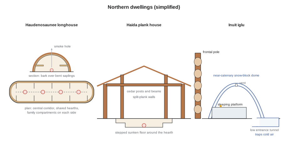
- The Haudenosaunee longhouse. The Haudenosaunee (Iroquois Confederacy) of present-day Ontario, Quebec and New York State, and their Wendat (Huron) neighbours, lived in villages of longhouses framed with bent saplings and covered with sheets of elm or other bark. A longhouse could be 6 to 7 m (20 to 23 ft) wide and 20 to 60 m (65 to 200 ft) or more long. Inside, a central corridor ran its length, with a line of hearths down the middle; each hearth was shared by two families living in compartments on either side, with sleeping platforms and storage above. Smoke rose through openings in the roof. A longhouse was the home of an extended family related through the female line, and it could be lengthened as the family grew. The Haudenosaunee call themselves the People of the Longhouse, and the house is also a symbol of the Confederacy itself.
- The Haida plank house. On Haida Gwaii, off the coast of British Columbia, the Haida built large houses of western red cedar: a heavy post-and-beam frame with walls of split planks, and a gabled roof. Many had a sunken central floor with stepped platforms around it and a central hearth. A carved frontal pole at the entrance displayed the crests and history of the family, and mortuary and memorial poles stood nearby. At SGang Gwaay Llnagaay (Ninstints), now a UNESCO World Heritage Site protected by the Haida Nation and Parks Canada, the remains of houses and poles stand at the edge of the forest. Plank houses of related types were built by many Northwest Coast nations, including the Kwakwaka'wakw, Nuu-chah-nulth and Coast Salish.
- The Inuit iglu and qarmaq. Inuit in the Arctic built several kinds of dwelling. The iglu (often spelled igloo in English) is a dome of blocks cut from wind-packed snow, laid in a rising spiral so that each block leans on the one before and the dome can be built without support. Its profile is close to a catenary, the ideal shape for a masonry dome under its own weight. A low entrance tunnel traps cold air, while a raised sleeping platform sits in the warmest air under the dome; a small vent controls moisture. Snow is an excellent insulator, and a small oil lamp can keep the interior well above the outside temperature. For longer winter stays, many Inuit and their Thule ancestors built the qarmaq, a semi-subterranean house of stone, sod and whalebone or driftwood framing.
- The tipi. On the Plains, nations including the Blackfoot (Niitsitapi), Cree and Lakota lived in tipis, cones of long poles covered with buffalo hide (later canvas), designed to be taken down, moved and set up quickly. The cone is tilted, steeper at the back, and two smoke flaps at the top can be adjusted to the wind to draw smoke from the central fire. An inner lining creates a layer of air for insulation and draws fresh air up behind it.
The iglu's shape can be checked with a little mathematics. A catenary arch of span s and height h has the shape y = h − a(cosh(x/a) − 1); the script below finds the value of a that fits a typical iglu and compares the result with a hemisphere of the same span.
import math

span, height = 3.6, 2.4         # a typical iglu: span and height in metres
half = span / 2
# find a so that a*(cosh(half/a) - 1) = height (catenary through the base corners)
lo, hi = 0.1, 50.0
for _ in range(100):
    a = (lo + hi) / 2
    if a * (math.cosh(half / a) - 1) > height:
        lo = a
    else:
        hi = a
print(f"catenary parameter a = {a:.3f} m")
print(" x (m)   catenary y   hemisphere y")
for i in range(0, 7):
    x = half * i / 6
    yc = height - a * (math.cosh(x / a) - 1)
    yh = math.sqrt(max(half ** 2 - x ** 2, 0)) * height / half
print(f"{x:5.2f} {yc:9.2f} {yh:9.2f}")catenary parameter a = 0.920 m x (m) catenary y hemisphere y 0.00 2.40 2.40 0.30 2.35 2.37 0.60 2.20 2.26 0.90 1.92 2.08 1.20 1.50 1.79 1.50 0.88 1.33 1.80 -0.00 0.00
The catenary is taller and steeper near its base than a hemisphere (even one stretched to the same height), which keeps the line of thrust inside the snow blocks and prevents the lower part of the dome from spreading. Inuit builders arrived at this shape through generations of practice.
| Place or building | Region | Date | Key idea |
|---|---|---|---|
| Watson Brake | Louisiana | c. 3500 BCE | Ring of earthen mounds built by hunter-gatherers |
| Caral | Peru | c. 2600 BCE | Platform mounds and sunken plazas |
| Teotihuacan | Valley of Mexico | c. 100 BCE–550 CE | Grid city on an axis; Pyramid of the Sun |
| Temple I, Tikal | Guatemala | c. 732–734 CE | Maya funerary temple with roof comb |
| Pueblo Bonito, Chaco | New Mexico | c. 850–1150 | D-shaped great house with kivas |
| Cahokia | Illinois | peak c. 1050–1200 | Mississippian city; Monks Mound |
| Cliff Palace, Mesa Verde | Colorado | c. 1190–1280 | Stone village in a cliff alcove |
| Machu Picchu | Peru | c. 1450 | Inca estate with ashlar temples and terraces |
| Haudenosaunee longhouse | Ontario, Quebec, New York | many centuries | Bark-covered extended-family house |
| Haida plank house | Haida Gwaii, British Columbia | many centuries | Cedar post-and-beam house with frontal pole |
| Iglu and qarmaq | Arctic | many centuries | Snow dome; sod and stone winter house |
Worked problem
Learning from Pueblo Bonito
Wren's Kestrel Point design has a south-facing slope. What can she learn, respectfully and accurately, from Pueblo Bonito's response to sun and climate?
Show solution
- Study the evidence: Pueblo Bonito's tall curved back wall shelters it on the north, and its rooms step down toward the south.
- In winter the low sun reaches deep into the terraced rooms and warms the thick masonry, which releases heat at night.
- In summer the high sun strikes mostly the roofs, and the mass keeps the interior cooler.
- Extract the principle, mass and terracing toward the winter sun, and acknowledge its source: an architecture of the Ancestral Puebloans, whose descendants are living Pueblo nations.
Answer: Wren can terrace her building down the south slope with thermal mass on the north, citing Pueblo Bonito as a precedent by name and culture, without imitating its forms or imagery.
Exercise 10: a dwelling and its climate
This exercise takes about five hours.
- Choose one dwelling type from this lesson: the longhouse, the plank house, the iglu, the tipi, the qarmaq or a Pueblo house.
- From published ethnographic and archaeological sources, and wherever possible from sources produced by the nation itself, draw a plan and section at a small scale.
- Annotate the section with the main climatic strategies: heat, air movement, smoke, moisture, light and snow or rain.
- Annotate the plan with social organization: who lives where, how space is shared, where the hearth is.
- Deliverable: one sheet with the drawings, notes and a list of sources, with a paragraph on how climate, material and community shape the form.
Precedent analysis: Cahokia's Grand Plaza
From published maps, draw Cahokia's central precinct at a small scale, showing Monks Mound, the Grand Plaza, the surrounding mounds and the palisade. Compare its size with a public square you know, such as The Forks in Winnipeg. Write a paragraph on how earthworks and open space created a civic centre without stone buildings.
Self-critique checklist
- Have I named specific nations and cultures, not just Native American or First Nations in general?
- Have I used present tense where traditions and nations continue today?
- Have I used Indigenous sources where available and noted where knowledge belongs to a community?
- Have I given estimates (such as Cahokia's population) as estimates, with ranges?
Common mistakes
MistakeTreating Indigenous architecture as primitive or simple.
InsteadDescribe the precise adaptation to climate, material and society, and the scale of works such as Cahokia and Chaco.
MistakeWriting as if these cultures ended at contact.
InsteadMany nations and building traditions continue; use present tense where appropriate.
MistakeGrouping all Indigenous peoples together.
InsteadName specific nations and regions: Haudenosaunee, Haida, Inuit, Ancestral Puebloans, Maya, Inca.
MistakeBorrowing sacred forms or imagery as decoration.
InsteadLearn principles respectfully and consult communities about their own heritage.
Summary and key terms
- The Americas developed many independent building traditions over at least fifteen thousand years.
- Mesoamerican cities such as Teotihuacan and Maya centres such as Tikal built axial plazas and temple pyramids tied to the calendar.
- Andean builders from Caral (c. 2600 BCE) to the Inca developed fine masonry, terracing and road networks; Inca walls resist earthquakes.
- In North America, earthworks from Watson Brake (c. 3500 BCE) to Cahokia (peak c. 1050–1200) and the great houses of Chaco Canyon show large-scale planning and astronomy.
- Northern dwellings, such as the Haudenosaunee longhouse, Haida plank house, Inuit iglu and qarmaq and the tipi, are precise responses to climate, material and community.
- Talud-tablero
- A Mesoamerican terrace profile of a sloping apron below a vertical framed panel.
- Ashlar
- Masonry of finely cut and fitted stones.
- Kiva
- A circular ceremonial room of Ancestral Puebloan and Pueblo communities.
- Great house
- A large multi-storey Chacoan building with hundreds of rooms.
- Longhouse
- A long bark-covered dwelling shared by an extended family, as among the Haudenosaunee.
Practice problems
Work each problem on paper first, then reveal the answer to check.
About when was Watson Brake built, and by whom?
Show answer
About 3500 BCE, by hunting, fishing and gathering communities in present-day Louisiana.
What was Cahokia's estimated population at its peak?
Show answer
An estimated ten thousand to twenty thousand people, around 1050 to 1200 CE.
Why are Inca walls resistant to earthquakes?
Show answer
Tightly fitted blocks without mortar, inward-leaning walls and trapezoidal openings let the stones shift and settle back.
What is the social organization of a Haudenosaunee longhouse?
Show answer
An extended family related through the female line, with pairs of families sharing hearths along a central corridor.
Why does an iglu have a low entrance tunnel?
Show answer
It traps cold air below the level of the living and sleeping platform, keeping warm air inside.
Lesson quiz · 5 questions
Score 60% or more to complete this lesson.
Create a free account to save your progress, take quizzes and earn a certificate.