
ROB-460 · Lesson 12 of 12 · 29 min
Capstone: designing a multi-robot field mission
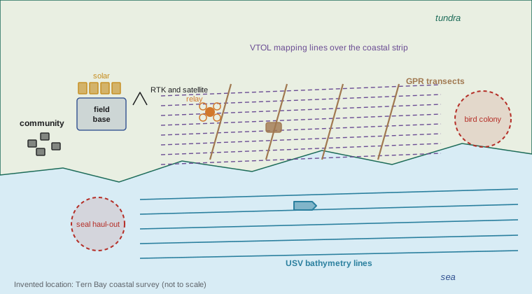
This capstone brings the course together in the design of a complete multi-robot field mission. The scenario is invented: a three-week summer survey of a stretch of Arctic coastline near a fictional community called Tern Bay, to measure shoreline erosion, map permafrost conditions and survey nearshore water depths. The same method applies to an agricultural, mining or offshore mission. You will work through requirements, the environment, the team, energy and logistics, localization and communication, task allocation, risk, approvals and community engagement, and a verification plan. Numbers are illustrative and chosen to exercise the methods of earlier lessons; a real mission would use measured data and local knowledge.
Step 1: mission requirements
Start with what the users need, not with the robots. Suppose the users are the community's land and environment office and a university research group. They want an orthomosaic and elevation model of 12 km of coastline in a strip 600 m deep, with 5 cm ground sample distance, to compare with earlier surveys; ground-penetrating radar profiles along 40 km of transects to estimate active layer depth over permafrost; and depth soundings out to 1 km offshore along 12 km of coast. Data must be delivered within two months, the field season window is about three weeks in July and August, and the community has asked that wildlife disturbance be minimized and that local people be employed and trained.
| Requirement | Measure | Source |
|---|---|---|
| Coastal mapping | 7.2 km² at 5 cm GSD, orthomosaic and elevation model | Research group and community office |
| Permafrost profiling | 40 km of GPR transects on land | Research group |
| Nearshore bathymetry | 12 km of coast to 1 km offshore, lines every 50 m | Community office (boating safety, erosion) |
| Schedule | Fieldwork within 21 days; data within two months | Funding and season constraints |
| Wildlife | Minimize disturbance; buffer zones around nesting colonies and marine mammals | Community and permits |
| Local benefit | Employ and train community members; share data under agreed terms | Community research agreement |
Step 2: environment and constraints
Place the mission on lesson 1's four axes. Structure is low: tundra, gravel beaches, eroding bluffs and shallow water, with little prior high-resolution mapping. Dynamics are moderate: tides, waves, drifting ice early in the season, wildlife and changing weather. Harshness is moderate in summer, with temperatures from about 0 to 15 degrees, fog, rain, wind and abrasive sand, but soft, wet active-layer soils make ground mobility hard (lesson 2). Remoteness is high: the nearest repair facility is a flight away, cellular coverage is limited to the community, and GNSS works but with high-latitude ionospheric effects (lesson 3). Continuous summer daylight helps solar charging and allows round-the-clock operation, although crews still need rest.
Step 3: choosing the team
Match platforms to tasks, using the trade-offs of lessons 2, 6 and 7. A hybrid VTOL drone suits the large coastal mapping task. A multirotor provides detailed imaging of eroding bluffs and serves as a communication relay. A tracked ground robot with low ground pressure carries the ground-penetrating radar along transects, where soft soils rule out heavy wheeled vehicles. An uncrewed surface vehicle with a single-beam or multibeam echo sounder runs bathymetry lines, avoiding the risk and cost of crewed small-boat survey. Two of each critical robot, or one spare across the fleet, gives the redundancy lesson 1 recommended.
# Team sizing: how many working days does each platform need? (illustrative performance values)
import math
tasks = {
  "VTOL mapping (7.2 km2 at 5 cm GSD)": dict(work=7.2, rate=1.6, unit="km2", hours_per_day=8, availability=0.85),
  "Multirotor bluff detail (12 km of bluff)": dict(work=12, rate=1.5, unit="km", hours_per_day=6, availability=0.85),
  "Tracked GPR robot (40 km transects)": dict(work=40, rate=1.2, unit="km", hours_per_day=10, availability=0.80),
  "USV bathymetry (12 km x 21 lines at 50 m)": dict(work=12 * 21, rate=6.0, unit="km", hours_per_day=12, availability=0.80),
}
weather_fly, weather_sea = 0.6, 0.5   # fraction of days suitable for flying and for small-vessel work
for name, t in tasks.items():
    hours = t["work"] / t["rate"]
    days = hours / (t["hours_per_day"] * t["availability"])
    suit = weather_sea if "USV" in name else weather_fly if ("VTOL" in name or "Multirotor" in name) else 0.85
    calendar = days / suit
print(f"{name:42s} {hours:5.1f} h of work -> {days:4.1f} working days -> {calendar:4.1f} calendar days")VTOL mapping (7.2 km2 at 5 cm GSD) 4.5 h of work -> 0.7 working days -> 1.1 calendar days Multirotor bluff detail (12 km of bluff) 8.0 h of work -> 1.6 working days -> 2.6 calendar days Tracked GPR robot (40 km transects) 33.3 h of work -> 4.2 working days -> 4.9 calendar days USV bathymetry (12 km x 21 lines at 50 m) 42.0 h of work -> 4.4 working days -> 8.7 calendar days
The bathymetry is the longest task, because many lines are needed and only half of days are expected to be calm enough for a small surface vehicle. On average a single USV needs under nine calendar days, which looks comfortable within 21, but a single unit has no backup: one failure, or a long run of rough weather, stops the bathymetry. A second USV, or a wider line spacing agreed with users, would reduce schedule risk. The mapping and GPR tasks fit comfortably, leaving margin for repeat flights after poor weather or for extra transects.
Step 4: energy, logistics and field base
A field base near the community provides charging, storage, a workshop with spares, and accommodation. Summer daylight allows solar charging, backed by a small generator for cloudy periods. Size the energy system from daily loads: drone battery charging, the ground robot's batteries, USV batteries, computing and communications. Spares should cover the most likely failures from lesson 1's reliability analysis: propellers, drone batteries, tracks and drive belts, connectors and sensors. Plan transport of the robots, batteries (subject to dangerous goods rules for lithium batteries in air freight) and fuel to the community well in advance, because northern air and sealift schedules are limited and expensive.
Worked problem
Daily energy budget for the field base
Daily charging loads are: VTOL drone 8 kWh, multirotor 3 kWh, tracked robot 12 kWh, USV 10 kWh, base computing and communications 4 kWh. Solar panels produce about 0.9 kWh per kW of rated capacity per day on average in the area's summer conditions over 24 h of daylight, with large day-to-day variation. Size a solar array to cover 80 percent of loads on an average day, and estimate generator energy on a cloudy day when solar output is a third of average.
Show solution
- Total daily load: \( 8 + 3 + 12 + 10 + 4 = 37 \) kWh.
- Solar target: \( 0.8 \times 37 = 29.6 \) kWh, so rated capacity \( 29.6 / 0.9 \approx 33 \) kW. That is large; reducing loads by charging only what each day needs is worth considering.
- A smaller 15 kW array gives about 13.5 kWh on an average day; on a cloudy day, about 4.5 kWh.
- Generator energy on a cloudy day with the 15 kW array: \( 37 - 4.5 = 32.5 \) kWh.
Answer: Covering 80 percent of loads by solar needs about 33 kW of panels; a smaller array with a generator is more practical, and the plan should include fuel for several cloudy days. The yield figure is illustrative; use measured local solar data.
Step 5: localization and communication architecture
Survey accuracy requirements drive localization. An RTK base station at the field base, with its position determined by post-processing against the national reference frame (for example with a PPP service), provides corrections to the drones, ground robot and USV within radio range; the drones also record raw GNSS for post-processed kinematic correction if the link drops, and ground control points checked by the survey team validate the mapping. The USV combines RTK with an inertial unit and must correct depth soundings for tides and vessel motion. The GPR robot localizes with RTK and dead reckoning when it passes behind ridges, using lesson 3's drift analysis to set how far it may travel without a fix.
The communication architecture follows lesson 11. A LEO satellite terminal at the base provides backhaul for supervision, weather data and remote expert support. A 900 MHz telemetry network carries commands and status from all robots back to the base over several kilometers; a mesh network at 2.4 GHz carries higher-rate data when in range, with the multirotor acting as an airborne relay for the ground robot behind bluffs. Bulk data, such as tens of gigabytes of imagery per day, is offloaded when robots return to base rather than streamed. Each robot has a defined link-loss behavior: the drones return home after a timeout, the ground robot stops and waits, and the USV holds position or returns along its last safe track.
# Mission success over the season: Monte Carlo with weather, failures and spares (illustrative)
import numpy as np
rng = np.random.default_rng(2026)
days, trials = 21, 4000
def run(n_usv):
    done = 0
    for _ in range(trials):
        work_needed, work_done = 4.4, 0.0          # USV working days required
        units = n_usv
        for d in range(days):
            calm = rng.random() < 0.5
            failures = rng.binomial(units, 0.04)    # 4 % chance a unit fails on a given day
            units -= failures
            if units == 0:
                break
            if calm:
                work_done += min(units, 2) * rng.uniform(0.7, 1.0)   # partial days happen
            if work_done >= work_needed:
                done += 1; break
    return done / trials
for n in (1, 2, 3):
print(f"{n} USV(s): probability of finishing bathymetry in {days} days = {run(n):.2f}")1 USV(s): probability of finishing bathymetry in 21 days = 0.64 2 USV(s): probability of finishing bathymetry in 21 days = 0.91 3 USV(s): probability of finishing bathymetry in 21 days = 0.98
The simulation supports the earlier judgment: one surface vehicle gives only a moderate chance of finishing in a season where half the days are rough and units occasionally fail, while two vehicles make success likely. A third adds little. Monte Carlo analyses like this are cheap and make risk visible to funders and users; they should be updated with real weather statistics and failure rates from earlier campaigns.
Step 6: task allocation and daily operations
Each day begins with a planning meeting that reviews the weather, robot health and progress. Survey blocks, transects and bathymetry lines are divided among available robots, using optimal assignment (lesson 9) for the morning allocation and auctions to reallocate work when a robot fails or a weather window opens. Flight and vessel plans respect buffer zones around wildlife and the community. One supervisor monitors the drones and one the ground robot and USV, with a field technician for maintenance; with neglect times of tens of minutes and interactions of a few minutes, lesson 11's analysis suggests each supervisor can handle two or three robots with spare capacity for clustered events. Data is checked for quality every evening, and gaps are re-planned for the next day.
Step 7: risk assessment
A risk assessment, using the methods of ROB-450, covers people, wildlife, equipment and the mission. Hazards to people include polar bears, which require trained wildlife monitors and safety plans for anyone outside; cold water near the shore; and handling of lithium batteries and fuel. Hazards to wildlife include disturbance of nesting birds and hauled-out seals by drones and vessels; mitigations include flight altitudes and buffer distances set with biologists and the community, and avoiding sensitive areas at sensitive times. Hazards to the mission include fog and wind grounding drones, icing in early-season fog, soft ground stopping the ground robot, and loss of the USV in surf. Each hazard gets controls and an owner, and the plan includes a decision process for stopping work.
| Hazard | Consequence | Main controls |
|---|---|---|
| Polar bear encounter | Serious injury to field crew | Wildlife monitors, deterrents, check-in procedures, robots used to reduce time crews spend on foot |
| Drone disturbance of nesting birds | Nest abandonment, permit breach | Buffer zones, minimum altitudes, timing, monitoring by a biologist |
| USV in surf or ice | Vehicle loss, debris | Sea state limits, ice watch, recovery plan, geofence |
| Ground robot stuck in thawed soil | Lost days, recovery effort | Ground pressure check, slip monitoring, route planning from drone maps, recovery kit |
| Lithium battery fire | Injury, loss of equipment | Fireproof charging containers, monitoring, storage separation, training |
| Communication loss | Robots out of control or idle | Defined link-loss behaviors, telemetry backup, relays |
Step 8: approvals, community engagement and data governance
Field missions require approvals from several authorities, and in northern regions research is subject to licensing and community agreements. The robotics team should plan these months ahead.
In an equivalent Alaskan scenario, the team would need: permission from landowners, which may include Alaska Native corporations, tribes and state or federal land managers; permits under wildlife law, including the Marine Mammal Protection Act for activities that may disturb seals, walrus or polar bears, the Endangered Species Act where listed species are involved and the Migratory Bird Treaty Act; FAA authorizations under Part 107 and any waivers for beyond-visual-line-of-sight flights, as summarized in ROB-450; FCC-authorized radio equipment; and consultation with tribal governments. The CARE principles for Indigenous data governance (collective benefit, authority to control, responsibility, ethics) are widely used alongside open data principles. The team should agree in writing with the community how data will be owned, stored, shared and used, and how local people will be involved.
Community engagement is not a formality. Local knowledge about weather, ice, wildlife and safe travel improves the mission, and community members trained as robot operators and technicians add capacity and leave lasting skills. Data sovereignty matters because coastal and land data can affect hunting, travel, infrastructure and land claims.
Step 9: verification, validation and metrics
Before deployment, verify each robot and the whole system: bench tests of sensors and communications; a full rehearsal at a southern test site with similar terrain, including link-loss and fault scenarios; checks of mapping accuracy against surveyed control points; and testing of the data pipeline from robot to final product. During the mission, track the metrics from lesson 1: availability, interventions per day, area or line kilometers completed per day, data quality rejections, and incidents. After the mission, hold a review with the community and users, compare results with requirements, and record lessons for the next season.
| Deliverable for the capstone | Content |
|---|---|
| Concept of operations | Mission description, team, daily cycle, roles, link-loss and fault behaviors |
| Engineering analyses | Coverage and schedule, energy budget, link budgets, localization accuracy, reliability and Monte Carlo schedule risk |
| Risk assessment | Hazards, consequences, controls and owners, including wildlife and community concerns |
| Approvals and engagement plan | Permits, licenses, research agreements, data governance and training |
| Verification and validation plan | Tests before deployment, acceptance criteria, mission metrics and review |
Common mistakes
MistakeChoosing robots first and fitting the mission to them.
InsteadStart from user requirements and constraints, then select platforms that meet them with margin.
MistakePlanning a schedule with no allowance for weather or failures.
InsteadInclude availability, weather statistics and spares, and test the schedule with Monte Carlo simulation.
MistakeStreaming all data over a satellite link.
InsteadOffload bulk data at base, send summaries and status over the link, and size backhaul for what must be live.
MistakeTreating permits and community engagement as paperwork at the end.
InsteadStart months ahead, involve the community in design, and agree data governance in writing.
MistakeDeploying without a full rehearsal including faults.
InsteadRehearse at a representative site with link-loss, failure and recovery scenarios before traveling north.
Summary and key terms
- A field mission design starts with user requirements, schedule, constraints and community priorities.
- The four environmental axes guide hardening, mobility, localization and autonomy choices.
- Team composition matches platforms to tasks and adds redundancy for critical tasks.
- Energy, logistics and spares are planned from daily loads and reliability analysis, with long lead times in remote regions.
- Localization and communication architectures combine RTK, telemetry, mesh relays, satellite backhaul and defined link-loss behaviors.
- Task allocation, supervision ratios and Monte Carlo schedule risk analysis support daily operations and funding decisions.
- Risk assessment, approvals, community engagement, data governance and verification complete the mission plan.
- Concept of operations
- A description of how a system will be used, by whom and under what procedures.
- Ground control point
- A surveyed marker visible in imagery, used to check and adjust mapping accuracy.
- Ground-penetrating radar
- A sensor that sends radio pulses into the ground to image layers such as the active layer above permafrost.
- Active layer
- The surface layer of soil above permafrost that thaws each summer.
- Bathymetry
- Measurement of water depth and seabed shape.
- Monte Carlo simulation
- Estimating outcomes by simulating many random scenarios.
- Data sovereignty
- The right of a community or nation to govern data about its people, lands and resources.
- OCAP principles
- First Nations principles of ownership, control, access and possession of data.
- CARE principles
- Principles for Indigenous data governance: collective benefit, authority to control, responsibility and ethics.
- Rehearsal
- A full test of a mission in representative conditions before deployment.
Practice problems
Work each problem on paper first, then reveal the answer to check.
Why does the capstone start with requirements rather than robots?
Show answer
The mission exists to meet user needs; robots are chosen to satisfy requirements and constraints with margin.
Place the Tern Bay mission on the four environmental axes.
Show answer
Low structure, moderate dynamics, moderate harshness with soft soils, high remoteness.
Why is a tracked robot chosen for GPR transects?
Show answer
Low ground pressure suits soft, wet active-layer soils where wheeled robots would sink.
The USV needs 4.4 working days and only half of days are calm. How many calendar days does one USV need on average, ignoring failures?
Show answer
About 8.8 calendar days on average, but variability and failures make one unit risky in a 21-day window.
Name two reasons not to stream all imagery over satellite.
Show answer
Limited backhaul capacity and cost; data can be offloaded at base; links should be reserved for supervision and status.
What link-loss behavior would you specify for the USV, and why?
Show answer
Hold position or return along the last safe track, because drifting could put it into surf, ice or traffic.
Give two wildlife controls for drone flights.
Show answer
Buffer distances and minimum altitudes around colonies and haul-outs; avoiding sensitive periods; biologist monitoring.
Why should data governance be agreed in writing with the community?
Show answer
Data can affect land use, hunting, infrastructure and rights; clear agreements respect sovereignty and avoid disputes.
What should a pre-deployment rehearsal include?
Show answer
Full operations at a representative site, link-loss and fault scenarios, accuracy checks against control points and the full data pipeline.
List three metrics to track during the mission.
Show answer
Availability, interventions per day, work completed per day, data quality rejections, incidents.
Lesson quiz · 5 questions
Score 60% or more to complete this lesson.
Create a free account to save your progress, take quizzes and earn a certificate.