
GEOM-230 · Lesson 8 of 12 · 19 min
NAVD 88 and the coming NAPGD2022
The design of the new Missouri River bridge must keep its low chord above the base flood elevation shown on the current flood insurance rate map, and both numbers are in NAVD 88, the North American Vertical Datum of 1988. Within a few years, however, NGS expects to replace NAVD 88 with the North American–Pacific Geopotential Datum of 2022, NAPGD2022, and heights in Montana are expected to drop by something of the order of a meter. Leah Tran asked whether the bridge would therefore be lower. Ruth Albrecht explained that the bridge will not move at all; only the numbers will, and they will move together for every point in the area. The danger lies in mixing numbers from the two datums. This lesson describes NAVD 88, its known problems, GEOID18, and the geoid-based datum that will replace it.
From NGVD 29 to NAVD 88
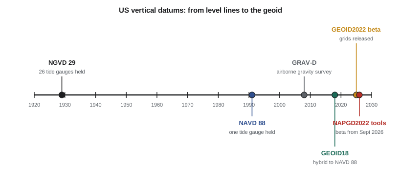
The first national vertical datum, the National Geodetic Vertical Datum of 1929 (NGVD 29, originally the Sea Level Datum of 1929), held 26 tide gauges in the United States and Canada fixed at local mean sea level and carried heights inland through the leveling network. Because sea level is not a level surface, forcing it to zero at many gauges distorted the network. NGVD 29 also used normal-orthometric corrections, without measured gravity, and its heights were disturbed over the decades by subsidence and by the movement of the crust.
NAVD 88 was the result of a new general adjustment of North American leveling, completed and published by NGS in 1991. It holds fixed the height of a single primary tidal benchmark at Father Point (Rimouski), Quebec, on the St. Lawrence River, and it uses Helmert orthometric heights computed from geopotential numbers with measured gravity. It was a large improvement, and it remains the official vertical datum of the United States. In Montana and much of the West, NAVD 88 heights are more than a meter higher than NGVD 29 heights of the same marks.
What is wrong with NAVD 88
Comparisons with GNSS and modern gravimetric geoid models have revealed systematic errors in NAVD 88 that grow across the continent. NGS describes the datum as biased by roughly half a meter relative to the best global geoid, and tilted by about a meter across the conterminous states, from south-east to north-west. The errors accumulated through tens of thousands of kilometers of leveling, from a single fixed point at Rimouski. Benchmarks have also been disturbed, destroyed or have subsided, especially along the Gulf Coast, where some have sunk by more than a meter. And the network depends on benchmarks that are expensive to maintain and not available everywhere.
Because NAVD 88 cannot be reached directly from GNSS, NGS publishes hybrid geoid models that convert NAD83 ellipsoidal heights to NAVD 88 heights. The current one, GEOID18, starts from a gravimetric geoid and is warped to fit thousands of benchmarks that have both GNSS-derived ellipsoidal heights and published NAVD 88 heights:
GEOID18 reproduces NAVD 88, including its tilt and bias, which is exactly what is wanted while NAVD 88 is the official datum. It is not an approximation of the true geoid.
NAPGD2022: a datum defined by the geoid
NAPGD2022 will replace NAVD 88, and the other vertical datums of US territories, with a datum defined by the gravity field rather than by leveling. Its reference surface is an equipotential surface with the same \(W_0 = 62\,636\,856.0\ \text{m}^2/\text{s}^2\) that Canada uses for CGVD2013, so heights will agree across the border. It is realized by a family of models. GEOID2022 gives the geoid height at a resolution of one arcminute, in the tide-free system, relative to GRS80 in the ITRF2020 frame, and includes both static and time-dependent components. DEFLEC2022 gives deflections of the vertical at the Earth's surface, GRAV2022 gives surface gravity, and GM2022 is a time-dependent global geopotential model to degree and order 2190. Heights will come from GNSS:
where NATRF2022 is the new North American terrestrial reference frame that replaces NAD83. The airborne gravity collected by the GRAV-D project, together with satellite and terrestrial gravity, is what makes a centimeter-level geoid possible across the country.
NGS released the NAPGD2022 grids, along with the new reference frames and the 2022 State Plane Coordinate System, to its beta website in June 2025 for review and testing. On September 15, 2026, it released beta versions of the modernized NSRS tools, starting about six months of beta testing; NGS will review user feedback before approving the modernized system. During the beta, the products are for testing only: official work continues on NAVD 88 and NAD83.
How big is the change?
Because NAPGD2022 removes the bias and tilt of NAVD 88, the change from NAVD 88 to NAPGD2022 is largest in the north-west and smallest in the south-east. Estimates from GPS on benchmarks have shown average changes of about −1.1 m in Washington and −1.0 m in Oregon, and about −0.3 m in North Carolina. Montana lies in the part of the country where changes approach a meter, so most heights in the state will become smaller by several decimeters to about a meter. The change varies smoothly, typically by a few centimeters over tens of kilometers, so relative heights within a project change very little.
The real risk is in combining numbers. A flood elevation, a sewer invert or a bridge clearance computed in one datum and compared with a value in another will be wrong by the full datum change. Flood maps, permits, as-built drawings and GIS layers will all be converted over a period of years, not on one day, so for some time both datums will be in use side by side.
Worked problem
Datum mixing at the bridge
The base flood elevation at the bridge is 1019.40 m NAVD 88 and the design low chord is 1021.25 m NAVD 88. For this exercise, take the predicted change from NAVD 88 to NAPGD2022 at the site as −0.850 m. What clearance would be computed if the low chord were converted to NAPGD2022 and compared with the unconverted flood elevation?
Show solution
- \[\text{clearance}_{88} = 1021.25 - 1019.40 = 1.85\ \text{m}\]
- \[\text{low chord}_{2022} = 1021.25 - 0.850 = 1020.40\ \text{m}\]
- \[\text{mixed} = 1020.40 - 1019.40 = 1.00\ \text{m}\]
- \[\text{both converted} = (1021.25 - 0.850) - (1019.40 - 0.850) = 1.85\ \text{m}\]
Answer: The true clearance is 1.85 m in either datum. Mixing a converted low chord with an unconverted flood elevation would show only 1.00 m and might trigger a needless redesign; the reverse mistake would overstate the clearance by 0.85 m, which is far more dangerous.
# NAVD 88 today and NAPGD2022 tomorrow on the river project
W0 = 62636856.0                     # reference potential adopted for NAPGD2022, m^2/s^2

# 1. NAVD 88 height of CR1 from GNSS with the hybrid geoid GEOID18
h83 = 1004.826                      # NAD83(2011) ellipsoidal height, epoch 2010.00
N18 = -15.098                       # GEOID18 value at CR1
H88 = h83 - N18
print("NAVD 88 height of CR1 =", format(H88, ".3f"), "m")

# 2. Predicted change at the site, read from the NGS change grid (value used for this exercise)
dH = -0.850                         # NAPGD2022 minus NAVD 88, m
H22 = H88 + dH
print("expected NAPGD2022 height of CR1 =", format(H22, ".3f"), "m")

# 3. Design and regulatory elevations must be in the same datum
bfe88 = 1019.40                     # base flood elevation on the current flood map, NAVD 88
deck88 = 1021.25                    # bridge low chord in the design, NAVD 88
print("low chord clearance above flood, NAVD 88:", round(deck88 - bfe88, 2), "m")
print("mixing datums (low chord in NAPGD2022, flood in NAVD 88):", round(deck88 + dH - bfe88, 2), "m  <- wrong")
print("both in NAPGD2022:", round((deck88 + dH) - (bfe88 + dH), 2), "m")

# 4. The same height as a potential difference: C = W0 - W and H = C / mean gravity
gbar = 9.805530 + 0.0424e-5 * 1019.9  # Helmert mean gravity along the plumb line at CR1
C = H22 * gbar
print("geopotential number C =", round(C, 3), "m^2/s^2, so W at the pillar =", round(W0 - C, 3), "m^2/s^2")

# 5. Old NGVD 29 values from a 1960s drawing, converted with a local shift from benchmarks
pairs = [(1018.912, 1020.071), (1003.540, 1004.702)]   # (NGVD 29, NAVD 88) at two benchmarks
shift = sum(b - a for a, b in pairs) / len(pairs)
print("NAVD 88 minus NGVD 29 here =", round(shift, 3), "m; old intake sill 1001.20 ->", round(1001.20 + shift, 3), "m NAVD 88")NAVD 88 height of CR1 = 1019.924 m expected NAPGD2022 height of CR1 = 1019.074 m low chord clearance above flood, NAVD 88: 1.85 m mixing datums (low chord in NAPGD2022, flood in NAVD 88): 1.0 m <- wrong both in NAPGD2022: 1.85 m geopotential number C = 9993.001 m^2/s^2, so W at the pillar = 62626862.999 m^2/s^2 NAVD 88 minus NGVD 29 here = 1.161 m; old intake sill 1001.20 -> 1002.361 m NAVD 88
The program computes the NAVD 88 height of CR1 from its NAD83(2011) ellipsoidal height and GEOID18, applies the exercise value of the predicted change, and repeats the clearance check. It then expresses the NAPGD2022 height as a geopotential number, about 9993 m²/s², which is what the new datum really defines: a height in meters is the potential difference from \(W_0\) divided by mean gravity. Finally, it converts an intake sill elevation from a 1960s drawing in NGVD 29 using a local shift of +1.161 m determined at two benchmarks with both values. NGS's VERTCON tool performed such conversions over larger areas; within a small project, a shift from local benchmarks is often more accurate.
Preparing for the change
Surveyors and engineers can prepare now. Record the datum, geoid model and epoch with every height, such as NAVD 88 (GEOID18) or NAD83(2011) epoch 2010.00. Keep raw GNSS observations, not only the final heights, so that they can be reprocessed in NATRF2022 and NAPGD2022. Tie projects to CORS and to stable benchmarks, and test the beta products on known marks while they are available for comparison. When the new datum is adopted, NGS's transformation tool, NCAT, will convert coordinates and heights between the old and new systems.
A project workflow
On the bridge, Coulee Geomatics follows a routine that applies to any project needing NAVD 88 heights today. First, the GNSS control is processed against NOAA CORS Network stations, for example through OPUS, and the results are expressed in NAD83(2011) at epoch 2010.00. Second, ellipsoidal heights are converted to NAVD 88 with GEOID18, using the official grid and NGS software or a program that reproduces it exactly. Third, at least two, and preferably three or more, existing benchmarks with published NAVD 88 heights are occupied as checks. Differences of a centimeter or two are normal; larger ones prompt a search for disturbed marks, wrong antenna heights or mixed epochs. Fourth, any heights inherited from older drawings are converted from NGVD 29 with a documented shift or tool. Finally, the report states the datum, the geoid model, the frame and epoch, the benchmarks used as checks and their residuals.
This routine also protects the client when NAPGD2022 is adopted. Because the raw GNSS data, the frame and epoch, and the geoid model are all recorded, the heights can be recomputed in the new datum with the official tools, and the size of the change at the project can be stated exactly instead of being estimated.
Common mistakes
MistakeComparing a NAPGD2022 height with a NAVD 88 flood elevation.
InsteadConvert both values to the same datum before comparing.
MistakeTreating GEOID18 as the true geoid.
InsteadGEOID18 is a hybrid model fitted to NAVD 88, with that datum's bias and tilt.
MistakeAssuming the datum change will move structures.
InsteadOnly the numbers change; physical clearances and gradients stay the same.
MistakeUsing beta NAPGD2022 products for official work.
InsteadBeta products are for testing until NGS approves the modernized system.
MistakeUsing one NGVD 29 to NAVD 88 shift over a large area.
InsteadThe shift varies; use local benchmarks or a grid-based tool.
Summary and key terms
- NGVD 29 held 26 tide gauges; NAVD 88 holds one tidal benchmark at Rimouski, Quebec, and uses Helmert orthometric heights.
- NAVD 88 is biased by roughly half a meter and tilted by about a meter across the conterminous states.
- GEOID18 is a hybrid model that converts NAD83(2011) ellipsoidal heights to NAVD 88.
- NAPGD2022 is defined by W0 = 62 636 856.0 m²/s² and realized by GEOID2022, DEFLEC2022, GRAV2022 and GM2022.
- NGS released beta grids in June 2025 and beta tools on September 15, 2026, for about six months of testing.
- Heights in Montana are expected to drop by several decimeters to about a meter; never mix datums.
- NGVD 29
- The National Geodetic Vertical Datum of 1929, fixed to 26 tide gauges.
- NAVD 88
- The North American Vertical Datum of 1988, fixed at one tidal benchmark at Rimouski, Quebec.
- GEOID18
- The NGS hybrid geoid model relating NAD83(2011) ellipsoidal heights to NAVD 88.
- NAPGD2022
- The North American–Pacific Geopotential Datum of 2022, a geoid-based vertical datum that will replace NAVD 88.
- GEOID2022
- The geoid model that realizes NAPGD2022.
- NATRF2022
- The North American Terrestrial Reference Frame of 2022, which will replace NAD83.
Practice problems
Work each problem on paper first, then reveal the answer to check.
A GNSS height in NAD83(2011) is 1 112.406 m and GEOID18 gives N = −14.882 m. What is the NAVD 88 height?
Show answer
1 112.406 + 14.882 = 1 127.288 m.
A NAVD 88 height is 1 050.000 m and the predicted change is −0.92 m. What NAPGD2022 height is expected?
Show answer
1 049.08 m.
A culvert invert is 1 001.35 m NAPGD2022 and the ditch outlet is 1 002.10 m NAVD 88, with a change of −0.85 m. Which way will water flow?
Show answer
The outlet is 1 001.25 m in NAPGD2022, so the invert is 0.10 m higher than the outlet and water flows toward the outlet.
What single point is held fixed in NAVD 88?
Show answer
The primary tidal benchmark at Father Point (Rimouski), Quebec.
What W0 defines NAPGD2022?
Show answer
62 636 856.0 m²/s², the same value as CGVD2013.
Lesson quiz · 5 questions
Score 60% or more to complete this lesson.
Create a free account to save your progress, take quizzes and earn a certificate.