
GEOM-230 · Lesson 11 of 12 · 19 min
Earth rotation and time
The astronomic longitude of lesson 9 came from comparing local sidereal time with Greenwich sidereal time at the same instant, and Theo Martel took that instant from a GNSS receiver. Between the receiver's clock and the rotation of the Earth lies a chain of time scales and corrections: GPS time, international atomic time, coordinated universal time, universal time and sidereal time, each with its own definition and its own reason for existing. The pole about which the Earth turns also wanders by several meters. A geodesist needs to understand both, because they link the terrestrial frame in which coordinates are expressed to the celestial frame in which stars, quasars and satellite orbits are described. This lesson explains sidereal time, the Earth rotation angle, the main time scales and polar motion.
Solar and sidereal days
A solar day is the time between successive transits of the Sun across the meridian, 24 hours on average. A sidereal day is the time between successive transits of a distant star, or more precisely of the vernal equinox. They differ because the Earth moves along its orbit. During one rotation the Earth advances about a degree around the Sun, so it must turn about 361° to bring the Sun back to the meridian, but only 360° to bring back a star. The mean sidereal day is therefore shorter, 23 h 56 min 4.091 s of solar time, and there is one more sidereal day than solar days in a year.
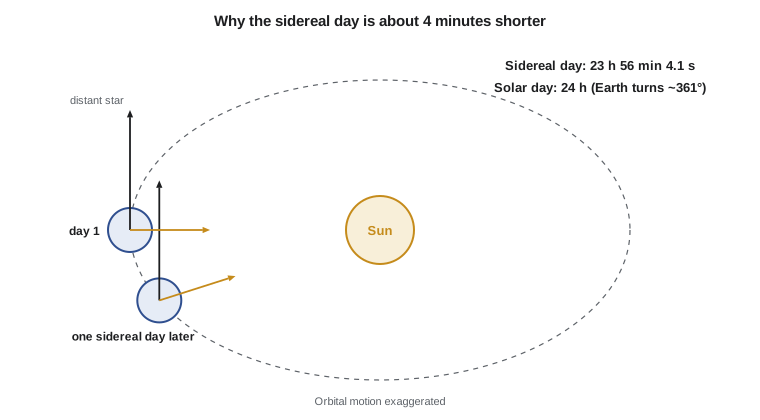
Sidereal time at a place is the hour angle of the vernal equinox, which equals the right ascension of stars on the local meridian. Greenwich mean sidereal time (GMST) is computed from universal time by a conventional formula; the classical form, adequate for most purposes, is
where \(D_0\) is the number of days from 2000 January 1, 12h UT1 to the previous midnight, \(H\) the hours of UT1 since that midnight and \(T\) the number of centuries since 2000. Local mean sidereal time is GMST plus the longitude converted to hours. Apparent sidereal time adds the equation of the equinoxes, at most about 1.1 seconds, caused by nutation.
The Earth rotation angle
Since 2003 the international conventions describe the Earth's rotation more cleanly through the Earth rotation angle (ERA), the angle between two non-rotating reference points, one on the celestial equator and one on the terrestrial equator. It is a strictly linear function of UT1:
where \(D_U\) is the number of UT1 days since 2000 January 1, 12h. In effect, the ERA is the modern definition of UT1. GMST equals the ERA plus the accumulated precession of the equinox, about 4612″ per century, which is why the two differ by about 82 seconds of time in 2026.
Time scales
Several time scales are in use, and confusing them is a classic source of error.
Universal Time (UT1) is defined by the rotation of the Earth through the ERA. It is the time scale that astronomic longitude depends on, but it is not uniform, because the Earth's rotation rate varies.
International Atomic Time (TAI) is a uniform scale formed from about 450 atomic clocks in laboratories around the world, combined by the International Bureau of Weights and Measures. Its unit is the SI second.
Coordinated Universal Time (UTC) is the basis of civil time. It runs at the rate of TAI but is kept within 0.9 s of UT1 by inserting leap seconds. Twenty-seven leap seconds have been added since 1972, the last at the end of 2016, so that since 2017 TAI − UTC = 37 s. In 2022 the General Conference on Weights and Measures decided to allow the difference UT1 − UTC to grow beyond 0.9 s by 2035, effectively ending leap seconds; in recent years the Earth has been rotating slightly faster than in previous decades, so no leap second has been needed since 2016.
GPS time is the time scale of the GPS system. It was set equal to UTC on 6 January 1980 and does not include leap seconds, so it differs from TAI by a constant 19 s and from UTC by 18 s since 2017. Other GNSS have their own system times with similar offsets. Terrestrial Time (TT), used for ephemerides, is TAI + 32.184 s.
| Time scale | Basis | Relation (since 2017) |
|---|---|---|
| UT1 | Earth rotation (ERA) | UTC + DUT1, with |DUT1| < 0.9 s |
| TAI | Atomic clocks | UTC + 37 s |
| UTC | TAI with leap seconds | Civil time base |
| GPS time | GPS system clocks | UTC + 18 s = TAI − 19 s |
| TT | Ephemeris time scale | TAI + 32.184 s |
The difference DUT1 = UT1 − UTC is published by the International Earth Rotation and Reference Systems Service (IERS). For astronomic longitude, an error of 1 ms in UT1 shifts the result by 0.015″, about 0.3 m on the ground; using UTC instead of UT1, with an error that can reach 0.9 s, would shift it by up to 13.5″ or about 270 m.
The variable length of day
The Earth's rotation is not constant. Tidal friction, mainly from the Moon, slows it over geological time, lengthening the day by roughly 2 ms per century. Seasonal changes in the angular momentum of the atmosphere change the length of day by about a millisecond over the year. Exchanges of angular momentum between the core and mantle cause decade-long fluctuations of a few milliseconds. Large earthquakes and the redistribution of ice and water change it by microseconds. These variations are measured by VLBI observations of quasars, together with satellite techniques, and published by the IERS as Earth orientation parameters.
Polar motion
The Earth's rotation axis is not fixed in the body of the Earth. Relative to the crust, the instantaneous pole moves in a roughly circular path a few meters across. The two main components are the Chandler wobble, a free oscillation with a period of about 433 days and an amplitude that varies over the decades, and an annual motion driven by the seasonal redistribution of air and water. Their combination produces a beating pattern with a period of about six years. Superimposed on this is a slow drift of the mean pole of several centimeters per year, driven by the rebound of the crust after the last ice age and, more recently, by melting ice and changes in groundwater.
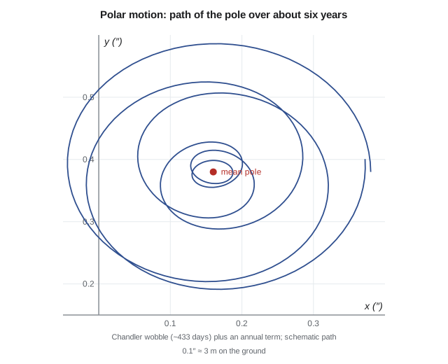
The pole position is expressed by coordinates \(x_p\) and \(y_p\), in arcseconds, relative to the IERS Reference Pole, with \(x_p\) toward the reference meridian and \(y_p\) toward 90° west. Typical values are a few tenths of an arcsecond, corresponding to several meters. Because astronomic latitude and longitude are measured relative to the instantaneous rotation axis, they must be reduced to the conventional pole before they are compared with geodetic coordinates. To first order, with \(\lambda\) positive east,
where the corrections are the observed values minus the conventional values. Polar motion also matters for GNSS: satellite orbits are computed in a celestial frame and must be rotated into the terrestrial frame using UT1, polar motion, precession and nutation. Errors in the Earth orientation parameters translate directly into errors of the orbits and therefore of positions.
Worked problem
Reducing astronomic coordinates for polar motion
On the observation night the IERS gives \(x_p = 0.182''\) and \(y_p = 0.334''\). Reduce the astronomic coordinates of CR1 (\(\Phi = 47^\circ 30' 23.96''\), \(\Lambda = -111.2992^\circ\)) to the conventional pole.
Show solution
- \[\cos\Lambda = -0.363\,3, \qquad \sin\Lambda = -0.931\,7, \qquad \tan\Phi = 1.091\,6\]
- \[\Delta\Phi = 0.182 \times (-0.363\,3) - 0.334 \times (-0.931\,7) = -0.066\,1 + 0.311\,2 = +0.245''\]
- \[\Delta\Lambda = \big(0.182 \times (-0.931\,7) + 0.334 \times (-0.363\,3)\big) \times 1.091\,6 = -0.290\,9 \times 1.091\,6 = -0.318''\]
- \[\Phi_0 = \Phi - \Delta\Phi = 47^\circ 30' 23.96'' - 0.25'' = 47^\circ 30' 23.71''\]
Answer: Polar motion shifts the observed latitude by +0.25″ and the longitude by −0.32″. Uncorrected, these would be about 7 m on the ground in each direction and would contaminate the deflection components of lesson 9 by a few tenths of an arcsecond.
Precession and nutation
The rotation axis also moves in space. The gravitational pull of the Sun and Moon on the equatorial bulge makes the axis sweep out a cone around the pole of the ecliptic once in about 26,000 years, the precession that slowly shifts the vernal equinox along the ecliptic and that makes GMST run ahead of the ERA. Superimposed on it is nutation, a set of periodic nodding motions, the largest with a period of 18.6 years and an amplitude of about 9″, tied to the regression of the Moon's orbital plane. Precession and nutation are modeled by conventional theories adopted by the International Astronomical Union, with small corrections observed by VLBI. They determine where a star appears on a given night and how celestial and terrestrial frames are linked.
# Sidereal time, the Earth rotation angle, time scales and polar motion
import math

def julian_date(y, mo, d, hh=0, mm=0, ss=0.0):          # Gregorian calendar, valid after 1582
    if mo <= 2:
        y, mo = y - 1, mo + 12
    A = y // 100; B = 2 - A + A // 4
    return int(365.25 * (y + 4716)) + int(30.6001 * (mo + 1)) + d + B - 1524.5 + (hh + mm / 60 + ss / 3600) / 24

def hms(hours):
    hours %= 24; h = int(hours); m = int((hours - h) * 60); s = (hours - h - m / 60) * 3600
    return str(h).zfill(2) + ":" + str(m).zfill(2) + ":" + format(s, "06.3f")

# Observation night: 15 October 2026, 03:30:00 UTC (21:30 local daylight time on the 14th)
dUT1 = 0.02                                   # UT1 - UTC from the IERS bulletin, seconds
jd_utc = julian_date(2026, 10, 15, 3, 30, 0.0)
jd_ut1 = jd_utc + dUT1 / 86400
print("JD (UTC) =", format(jd_utc, ".6f"))

# Earth rotation angle (IAU 2000) and the classical GMST series (IAU 1982, USNO form)
Du = jd_ut1 - 2451545.0
era = (0.7790572732640 + 1.00273781191135448 * Du) % 1.0 * 24          # in hours
T = Du / 36525
jd0 = math.floor(jd_ut1 - 0.5) + 0.5; H = (jd_ut1 - jd0) * 24
gmst = (6.697374558 + 0.06570982441908 * (jd0 - 2451545.0) + 1.00273790935 * H + 0.000026 * T * T) % 24
print("Earth rotation angle =", hms(era), "  GMST =", hms(gmst), "  difference", round((gmst - era) * 3600, 2), "s")

lam = -111.2978                               # longitude of CR1, degrees (east positive)
lmst = gmst + lam / 15
print("local mean sidereal time at CR1 =", hms(lmst))

# Day lengths
sidereal_day = 86400 / 1.00273790935
print("mean sidereal day =", hms(sidereal_day / 3600), "of solar time (", round(86400 - sidereal_day, 3), "s shorter )")

# Time scales on that night
TAI_UTC, GPS_UTC = 37, 18                     # seconds, unchanged since 2017
print("TAI = UTC +", TAI_UTC, "s;  GPS time = UTC +", GPS_UTC, "s;  TT = TAI + 32.184 s = UTC +", TAI_UTC + 32.184, "s")

# Polar motion: reduce observed astronomic coordinates to the conventional terrestrial pole
xp, yp = 0.182, 0.334                         # pole coordinates, arcsec (IERS bulletin)
Phi, Lam = 47 + 30 / 60 + 23.96 / 3600, -(111 + 17 / 60 + 57.15 / 3600)
l, p = math.radians(Lam), math.radians(Phi)
dPhi = xp * math.cos(l) - yp * math.sin(l)                   # observed minus conventional
dLam = (xp * math.sin(l) + yp * math.cos(l)) * math.tan(p)
print("polar motion: dPHI =", round(dPhi, 3), "arcsec, dLAMBDA =", round(dLam, 3), "arcsec")
print("on the ground: ", round(dPhi * 30.9, 1), "m north-south and", round(dLam * 20.9, 1), "m east-west")
print("a 1 ms error in UT1 shifts astronomic longitude by", round(15 * 0.001, 3), "arcsec =", round(15 * 0.001 * 20.9, 2), "m here")JD (UTC) = 2461328.645833 Earth rotation angle = 05:03:22.142 GMST = 05:04:44.515 difference 82.37 s local mean sidereal time at CR1 = 21:39:33.043 mean sidereal day = 23:56:04.091 of solar time ( 235.909 s shorter ) TAI = UTC + 37 s; GPS time = UTC + 18 s; TT = TAI + 32.184 s = UTC + 69.184 s polar motion: dPHI = 0.245 arcsec, dLAMBDA = -0.318 arcsec on the ground: 7.6 m north-south and -6.6 m east-west a 1 ms error in UT1 shifts astronomic longitude by 0.015 arcsec = 0.31 m here
The program computes the Julian date of the observation, 15 October 2026 at 03:30 UTC, which was 21:30 local daylight time the previous evening. It adds the small DUT1 to get UT1 and evaluates both the Earth rotation angle and GMST; their difference of about 82 seconds is the accumulated precession since 2000. Adding the longitude gives the local sidereal time, which tells the observer which stars are on the meridian. The table of time scales shows why receiver time cannot be used directly as Earth rotation time: GPS time is 18 s ahead of UTC, which could be up to 0.9 s from UT1. The polar motion corrections reproduce the worked example, and the last line shows the sensitivity of longitude to timing.
Who provides Earth orientation parameters
The IERS combines VLBI, satellite laser ranging, GNSS and DORIS observations into Earth orientation parameters: polar motion, UT1 − UTC, the length of day and corrections to the precession–nutation model. Its rapid service publishes daily values and predictions, used by GNSS control segments and real-time applications, and its final combined series is used for precise work after the fact. VLBI is the only technique that measures UT1 directly, because it alone observes the Earth's orientation against the distant quasars that define the celestial reference frame; satellite techniques track its rate of change. The same observations also define the ITRF of lesson 12, so Earth rotation and terrestrial reference frames are products of one integrated system.
Common mistakes
MistakeUsing UTC or GPS time where UT1 is needed.
InsteadApply DUT1 and, for GPS time, the 18 s offset; UT1 is what longitude depends on.
MistakeTreating the sidereal day as 24 hours.
InsteadIt is about 3 min 56 s shorter than the mean solar day.
MistakeIgnoring polar motion in astronomic positioning.
InsteadReduce observed Φ and Λ to the conventional pole; the effect reaches several meters.
MistakeAssuming the length of day is constant.
InsteadIt varies by milliseconds over seasons and decades.
MistakeConfusing the Earth rotation angle with GMST.
InsteadGMST includes accumulated precession; in 2026 the two differ by about 82 s of time.
Summary and key terms
- A sidereal day, 23 h 56 min 4.091 s, is one rotation relative to the stars; a solar day is about 4 minutes longer.
- The Earth rotation angle is a linear function of UT1; GMST adds accumulated precession.
- UT1 follows the Earth's rotation; TAI is atomic; UTC is TAI with leap seconds; GPS time is UTC + 18 s since 2017.
- Leap seconds keep |UT1 − UTC| < 0.9 s; they are to be discontinued by 2035.
- The pole moves several meters in a Chandler and annual pattern; astronomic coordinates must be reduced to the conventional pole.
- Precession and nutation move the axis in space; the IERS publishes Earth orientation parameters.
- Sidereal time
- The hour angle of the vernal equinox; equal to the right ascension of stars on the local meridian.
- Earth rotation angle
- The conventional angle of the Earth's rotation, linear in UT1.
- UT1
- The time scale defined by the Earth's rotation.
- UTC
- Coordinated Universal Time, atomic time kept within 0.9 s of UT1 by leap seconds.
- Polar motion
- The movement of the Earth's rotation axis relative to the crust.
- Chandler wobble
- A free oscillation of the rotation axis with a period of about 433 days.
Practice problems
Work each problem on paper first, then reveal the answer to check.
How many seconds shorter than the mean solar day is the mean sidereal day?
Show answer
About 235.9 s.
What is GPS time at 12:00:00 UTC on a day in 2026?
Show answer
12:00:18 GPS time.
DUT1 = −0.12 s. What is UT1 when UTC is 05:00:00.00?
Show answer
04:59:59.88.
A pole coordinate of 0.30″ corresponds to about how many meters?
Show answer
About 0.30 × 30.9 = 9.3 m.
If UTC is used instead of UT1 when DUT1 = 0.4 s, what longitude error results?
Show answer
0.4 × 15″ = 6″.
Lesson quiz · 5 questions
Score 60% or more to complete this lesson.
Create a free account to save your progress, take quizzes and earn a certificate.