
GEOM-230 · Lesson 1 of 12 · 23 min
History and scope of geodesy
In her first week at Coulee Geomatics, intern Leah Tran opened the control file for the Missouri River bridge and counted the reference surfaces in it: an ellipsoid called GRS80, a geoid model called GEOID18, a vertical datum called NAVD 88, a frame called NAD83(2011) at epoch 2010.00, and a state plane projection on top of all of them. "Why does a bridge need five different Earths?" she asked Ruth Albrecht. Ruth's answer was that it needs only one Earth, but that the Earth is a lumpy, spinning, slowly deforming body, and each of those names describes one part of how we measure it. Explaining that answer properly is the subject of this course. Geodesy is the science that supplies the surfaces, frames and numbers on which every survey, map and GNSS position rests.
The German geodesist Friedrich Robert Helmert defined geodesy in 1880 as the science of the measurement and mapping of the Earth's surface. Modern definitions are broader. Geodesy today is usually described as resting on three pillars: the geometry of the Earth (its size, shape and the positions of points on it), its gravity field (which defines the vertical and heights), and its rotation and orientation in space. All three change with time, so a fourth theme runs through the others: monitoring how the Earth deforms, how its masses move and how its spin varies. This lesson traces how these ideas developed and outlines what the rest of the course covers.
A round Earth, and how big it is
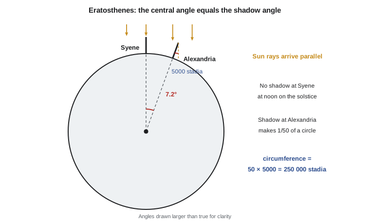
Greek philosophers argued for a spherical Earth from everyday evidence: the curved shadow of the Earth on the Moon during an eclipse, ships disappearing hull first over the horizon, and new stars appearing as a traveler moves south. The first measurement of its size that has come down to us is usually credited to Eratosthenes of Cyrene, librarian at Alexandria in the third century BC. He knew that at noon on the summer solstice the Sun shone straight down a well at Syene, near modern Aswan, so it stood at the zenith there. At the same moment in Alexandria, almost due north, a vertical gnomon cast a shadow showing that the Sun was about one fiftieth of a full circle, 7.2°, from the zenith.
Because the Sun is so far away its rays arrive parallel, and simple geometry shows that the angle between the two verticals at the center of the Earth equals the shadow angle. The arc between the two cities therefore spans one fiftieth of the circumference. Taking the distance as 5000 stadia gave a circumference of 250,000 stadia. How good this was depends on the length of the stadion, which is uncertain; common modern readings give between about 39,000 and 46,000 km, bracketing the true meridian circumference of about 40,008 km. The method is more important than the number. Eratosthenes combined an astronomical observation, an angle between two verticals, with a terrestrial one, a distance on the ground. That combination of an arc length and the change in the direction of the vertical along it is the arc measurement method, and it remained the main tool for finding the size and shape of the Earth for two thousand years.
Later measurements refined the size. Astronomers working for the caliph al-Ma'mun in the ninth century measured a degree of latitude on the plains of Mesopotamia. In 1615 the Dutch scientist Willebrord Snellius introduced triangulation, measuring a chain of triangles with angles and only one or two directly measured base lines, so that long arcs could be determined without chaining the whole distance. In 1669–70 Jean Picard used triangulation with telescopic sights to measure an arc near Paris, and his value for the Earth's radius was good enough for Isaac Newton to use when he tested his theory of gravitation against the motion of the Moon.
Flattened or elongated?
Newton went further. In the Principia of 1687 he argued that a rotating, self-gravitating fluid body must bulge at the equator and flatten at the poles, and he estimated the flattening at about 1/230. Measurements in France by the Cassini family seemed to show the opposite, an Earth elongated toward the poles. The question was not academic: navigation, cartography and the national prestige of two scientific traditions were involved.
The French Academy of Sciences settled it with two expeditions. One, led by Pierre Louis Maupertuis, measured an arc in Lapland near the Arctic Circle in 1736–37. The other, with Pierre Bouguer, Charles Marie de La Condamine and Louis Godin, worked near the equator in what is now Ecuador from 1735 to the 1740s. If the Earth is flattened, the meridian is flatter near the poles, its radius of curvature is larger there, and a degree of latitude is longer. The Lapland degree was indeed longer than the French and equatorial ones. The Earth is an oblate spheroid. The table in the program below shows how the length of one degree of latitude grows from about 110.6 km at the equator to about 111.7 km at the poles.
Two measured degree lengths are enough to solve for the two parameters of an ellipse, its equatorial radius and its flattening. The program demonstrates this, and also shows how sensitive the solution is: if the Lapland degree is 400 m too long, the computed inverse flattening drops from 298 to about 210. Maupertuis's own figure of roughly 1/178 is now understood to reflect errors of that kind in his arc. Geodesy is full of such lessons, where a small systematic error in one measurement dominates the result.
The meter and the nineteenth century
The French Revolution turned geodesy into the basis of a measurement system. The meter was defined in 1791 as one ten-millionth of the distance from the North Pole to the equator along the meridian of Paris. Jean-Baptiste Delambre and Pierre Méchain measured the arc from Dunkirk to Barcelona between 1792 and 1798 to realize it. Their arc contained small errors, and the meter bar made from it is about 0.2 mm shorter than one ten-millionth of the true quadrant, but the link between the unit of length and the size of the Earth is why the meridian circumference is so close to 40,000 km.
The nineteenth century brought long arcs across continents, such as the Struve Geodetic Arc from the Arctic Ocean to the Black Sea, measured between 1816 and 1855 and now a World Heritage Site. Different arcs gave slightly different ellipsoids, each fitting its own region best: Everest (1830) for India, Bessel (1841) for Europe and Clarke (1866) for North America. Clarke 1866 became the ellipsoid of the North American Datum of 1927 and remained in use on this continent for most of the twentieth century. In 1924 the International Union of Geodesy and Geophysics adopted the Hayford ellipsoid as the International Ellipsoid.
At the same time geodesists recognized that the plumb line, to which every astronomical and leveling observation is referenced, does not point along the normal to any ellipsoid. Mountains attract it, and so do hidden density variations. The real level surface of the Earth is irregular. Johann Benedict Listing gave it the name geoid in 1873, and Helmert and others developed physical geodesy, the study of the gravity field and its relation to the figure of the Earth. George Gabriel Stokes had already shown, in 1849, how the shape of the geoid could be computed from gravity measured over the whole Earth.
Satellites and the global view
Until the 1950s, geodesy was continental. Each region had its own datum, fixed by an initial point and its own ellipsoid, and the datums were not connected across oceans. The launch of Sputnik in 1957 changed this. The orbits of satellites are shaped by the Earth's gravity field, so tracking them revealed the flattening more precisely than any arc, and in 1958–59 tracking of Vanguard 1 showed the slight pear shape of the Earth. Within two decades, Doppler tracking of navigation satellites, laser ranging to satellites and the Moon, and very long baseline interferometry (VLBI) on distant quasars had tied the continents into a single global system with its origin at the Earth's center of mass.
The Geodetic Reference System 1980 (GRS80), adopted by the International Union of Geodesy and Geophysics in 1979, defined the ellipsoid and normal gravity field used by NAD83 and by most modern systems. WGS 84, the system of GPS, uses an ellipsoid that differs from GRS80 by a fraction of a millimeter. The International Terrestrial Reference Frame, now in its ITRF2020 version, combines VLBI, satellite laser ranging, GNSS and DORIS into the most accurate global frame available. Gravity missions such as GRACE (2002–2017), GOCE (2009–2013) and GRACE Follow-On (since 2018) mapped the geoid with centimeter accuracy at long wavelengths and now track the movement of water and ice month by month.
In the United States, geodesy began with the Survey of the Coast, established in 1807 under President Thomas Jefferson. It became the Coast and Geodetic Survey in 1878 and the National Geodetic Survey (NGS) in 1970. NGS maintains the National Spatial Reference System, including the NAD83 frame, the NOAA CORS Network of continuously operating GNSS stations, and the vertical datum NAVD 88. It is now modernizing the whole system, replacing NAD83 with NATRF2022 and NAVD 88 with the geoid-based NAPGD2022.
| Branch | Main questions | Examples in this course |
|---|---|---|
| Geometric geodesy | Size and shape of the Earth; positions and computations on the ellipsoid | Lessons 2–4 |
| Physical geodesy | Gravity field, geoid and heights | Lessons 5–8, 10 |
| Geodetic astronomy | Direction of the plumb line and orientation from stars | Lesson 9 |
| Earth rotation and time | Sidereal time, polar motion, time scales | Lesson 11 |
| Reference frames and networks | Datums, frames, transformations, crustal motion | Lesson 12 |
Why a surveyor needs geodesy
Plane surveying treats the Earth as flat over a small area, and for a building lot that is good enough. But the curvature of the Earth departs from a horizontal plane by \(d^2/2R\), which is about 8 cm at 1 km and 2 m at 5 km. Directions referred to north converge as one moves east or west. Plumb lines at two ends of a long bridge are not parallel. GNSS receivers compute positions in an Earth-centered frame on an ellipsoid, while engineers and regulators want heights above a level surface and coordinates on a map projection. Every one of these conversions is geodesy.
Worked problem
Curvature and a 7.2° arc
(a) How far does the Earth's surface fall below a horizontal line of sight over 1 km and over 5 km, using a mean radius of 6371 km? (b) Using a modern circumference of 40,008 km for the meridian, how long would Eratosthenes's 7.2° arc be?
Show solution
- \[c = \frac{d^2}{2R} \to c_{1\,\text{km}} = \frac{1000^2}{2 \times 6\,371\,000} = 0.0785\ \text{m}\]
- \[c_{5\,\text{km}} = \frac{5000^2}{2 \times 6\,371\,000} = 1.962\ \text{m}\]
- \[s = \frac{7.2^\circ}{360^\circ} \times 40\,008\ \text{km} = 800\ \text{km}\]
- The true distance from Aswan to Alexandria is roughly 840 km, and the two cities are not exactly on one meridian, so Eratosthenes's data contained small errors that partly canceled.
Answer: The surface falls 7.85 cm below the line of sight in 1 km and almost 2 m in 5 km, which is why long sights in leveling and trigonometric heighting must be corrected. A 7.2° arc of the meridian is about 800 km long.
# From Eratosthenes to the flattened Earth
import math

# 1. Eratosthenes: the Sun's shadow angle at Alexandria at noon on the solstice
angle = 7.2                      # degrees, 1/50 of a full circle
arc = 5000                       # stadia from Syene to Alexandria
circ = arc * 360 / angle
print("Eratosthenes: circumference =", round(circ), "stadia")
for stadion in (157.5, 185.0):   # two common modern readings of the stadion, in m
    print("  with a stadion of", stadion, "m:", round(circ * stadion / 1000), "km")

# 2. Length of one degree of latitude on a modern ellipsoid (GRS80)
a, f = 6378137.0, 1 / 298.257222101
e2 = f * (2 - f)
def M(lat):                      # meridian radius of curvature
    s = math.sin(math.radians(lat))
    return a * (1 - e2) / (1 - e2 * s * s) ** 1.5
deg = lambda lat: M(lat) * math.pi / 180
for lat in (0.0, 45.0, 49.7, 66.3, 90.0):
    print("one degree of latitude at", str(lat).rjust(4), "deg =", format(deg(lat), ",.1f"), "m")

# 3. Recover a and e2 from two measured degree lengths, as the 18th-century expeditions did
lat1, lat2 = 1.5, 66.3           # roughly Peru and Lapland
d1, d2 = deg(lat1), deg(lat2)    # pretend these were measured
s1, s2 = math.sin(math.radians(lat1)) ** 2, math.sin(math.radians(lat2)) ** 2
r = (d1 / d2) ** (2 / 3)         # d is proportional to (1 - e2 sin^2)^-1.5, so this is linear in e2
ee = (1 - r) / (s2 - r * s1)
aa = d1 * 180 / math.pi * (1 - ee * s1) ** 1.5 / (1 - ee)
ff = 1 - math.sqrt(1 - ee)
print("recovered a =", round(aa, 1), "m, 1/f =", round(1 / ff, 3))

# 4. Sensitivity: the same solution with the Lapland degree measured 400 m too long
def solve(d1, d2):
    r = (d1 / d2) ** (2 / 3)
    ee = (1 - r) / (s2 - r * s1)
    return 1 / (1 - math.sqrt(1 - ee))
print("Lapland degree 400 m too long -> 1/f =", round(solve(d1, d2 + 400), 1))Eratosthenes: circumference = 250000 stadia with a stadion of 157.5 m: 39375 km with a stadion of 185.0 m: 46250 km one degree of latitude at 0.0 deg = 110,574.3 m one degree of latitude at 45.0 deg = 111,131.8 m one degree of latitude at 49.7 deg = 111,223.3 m one degree of latitude at 66.3 deg = 111,511.8 m one degree of latitude at 90.0 deg = 111,694.0 m recovered a = 6378137.0 m, 1/f = 298.257 Lapland degree 400 m too long -> 1/f = 209.5
The first lines reproduce Eratosthenes's arithmetic and the range of results that different stadion lengths give. The table of degree lengths shows the effect of flattening: a degree near the site's latitude of about 49.7° is 111.2 km long, about 650 m longer than at the equator. The final lines solve the problem that the eighteenth-century expeditions faced. With error-free degree lengths at 1.5° and 66.3° the program recovers the GRS80 semi-major axis and inverse flattening exactly, but a 400 m error in the northern arc produces an inverse flattening of about 210, far from the truth. Two arcs are the bare minimum; redundant measurements, adjusted by least squares, are what make modern results reliable.
What this course covers
The next three lessons build the geometric toolkit: the ellipsoid and its radii of curvature, geodetic coordinates and their conversion to Earth-centered Cartesian coordinates, and the solution of distances and azimuths on the ellipsoid. Lessons 5 to 8 turn to gravity: normal gravity, the geoid, the different kinds of height, and the vertical datum used in practice. Lessons 9 and 10 connect the two through the direction of the plumb line, measured astronomically, and its deflection from the ellipsoid normal. Lesson 11 covers Earth rotation and time, which link terrestrial and celestial frames. Lesson 12 brings everything together in geodetic networks and reference frames, including the seven-parameter transformation used to move coordinates between frames. Throughout, the examples follow Coulee Geomatics's projects, so the formulas stay attached to real decisions.
Common mistakes
MistakeThinking the geoid and the ellipsoid are the same surface.
InsteadThe ellipsoid is a smooth mathematical figure; the geoid is a level surface of the gravity field that departs from it by tens of meters.
MistakeTreating Eratosthenes's result as an exact value.
InsteadHis method was sound but his data and units are uncertain; the method of combining arc length with the change in the vertical is the lasting contribution.
MistakeAssuming the Earth is elongated at the poles because the polar radius of curvature is larger.
InsteadThe polar radius of curvature is larger because the Earth is flattened there; the polar semi-axis is shorter.
MistakeIgnoring curvature on long sights.
InsteadThe surface drops about 8 cm in 1 km and 2 m in 5 km below a horizontal line.
MistakeAssuming one datum fits the whole world.
InsteadHistoric datums were regional; modern frames are global but still change with time and must be identified by name and epoch.
Summary and key terms
- Geodesy studies the Earth's geometry, gravity field and rotation, and how they change with time.
- Eratosthenes estimated the circumference by combining an arc length with the angle between verticals.
- Newton predicted an oblate Earth; arc measurements in Lapland and near the equator confirmed it.
- The meter was originally defined from the length of the meridian quadrant.
- Regional ellipsoids such as Clarke 1866 gave way to global systems such as GRS80 and WGS 84 after satellites tied the continents together.
- The geoid, named by Listing in 1873, is the level surface that heights refer to; it departs from any ellipsoid.
- Modern frames such as ITRF2020 combine VLBI, satellite laser ranging, GNSS and DORIS.
- Geodesy
- The science of the size, shape, gravity field and rotation of the Earth and their changes with time.
- Arc measurement
- Determining the Earth's dimensions from a measured arc length and the astronomically observed change in the vertical along it.
- Triangulation
- Fixing positions by measuring the angles of a chain of triangles from one or more measured base lines.
- Oblate spheroid
- An ellipsoid of revolution flattened at the poles.
- Geoid
- The level surface of the Earth's gravity field that best approximates mean sea level.
- Datum
- A set of conventions and constants defining a coordinate system, realized by coordinates of physical points.
Practice problems
Work each problem on paper first, then reveal the answer to check.
How far does the surface fall below a horizontal line over 2 km (R = 6371 km)?
Show answer
2000² / (2 × 6,371,000) = 0.314 m.
If the shadow angle had been 7.0° with the same 5000 stadia, what circumference would result?
Show answer
360 / 7.0 × 5000 = 257,143 stadia.
Is a degree of latitude longer in Alberta or in Ecuador? Why?
Show answer
In Alberta; the meridian is flatter at higher latitudes, so its radius of curvature is larger.
Name three techniques combined in ITRF2020.
Show answer
Any three of VLBI, satellite laser ranging, GNSS and DORIS.
What two kinds of observation does the arc measurement method combine?
Show answer
A terrestrial distance along the arc and an astronomical observation of the change in the direction of the vertical.
Lesson quiz · 5 questions
Score 60% or more to complete this lesson.
Create a free account to save your progress, take quizzes and earn a certificate.