
CIV-390 · Lesson 10 of 12 · 20 min
Cross-sections, roadside safety and active transportation
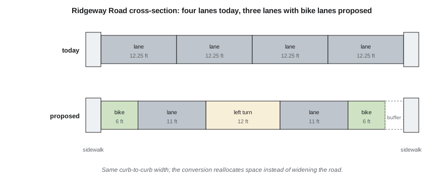
Ridgeway Road's western section is 15 m (49 ft) from curb to curb, striped for four 3.75 m (12 ft) lanes with no median and no space for anyone but drivers. Pedestrians cross four lanes of traffic to reach the high school, cyclists share the right lane with buses and trucks, and drivers turning left stop in a through lane, provoking rear-end crashes and sudden lane changes. The cross-section, the arrangement of lanes, medians, shoulders, curbs, sidewalks and roadsides across a road, determines much of how a road works and how safe it is. This lesson covers cross-section elements, the forgiving roadside and the clear zone, and the design of facilities for walking and cycling, and it tests a 'road diet' that would reallocate Ridgeway's width.
Elements of the cross-section
Travel lanes on arterials are typically 3.0 to 3.7 m (10 to 12 ft) wide. Wider lanes give more room for trucks and buses and a margin for driver error at higher speeds; narrower lanes save space for other uses and, on urban streets, are associated with somewhat lower speeds without measurable loss of safety in many studies. Current guides in both countries treat lane width as a choice within a range, tied to context, speed and vehicle mix, rather than a fixed minimum. Lanes have a cross slope of about 2 % so that water drains off; on undivided roads the crown is usually at the centerline.
Medians separate opposing traffic. A raised median prevents left turns except at openings, provides refuge for pedestrians crossing in two stages, and reduces head-on crashes; a flush median or a two-way left-turn lane (TWLTL) gives turning vehicles a place to wait out of the through lanes. Shoulders on rural roads provide space for stopped vehicles, recovery for errant drivers, structural support for the pavement edge and, often, room for cyclists. Urban streets use curbs instead of shoulders, with a gutter that carries drainage to inlets. Beyond the curb lie the boulevard or furnishing zone, which holds poles, trees, hydrants and snow, and the sidewalk.
In northern cities, the cross-section must also store snow. A boulevard of at least 2 m (6 to 7 ft) between curb and sidewalk keeps plowed snow off the sidewalk and away from the travel lanes; without it, snow is pushed onto sidewalks or narrows the road for months. Kestrel Bay's proposals for Ridgeway retain the existing boulevards for this reason.
The forgiving roadside and the clear zone
Drivers leave the road for many reasons: fatigue, distraction, ice, avoiding another vehicle, or simply misjudging a curve. Run-off-road crashes account for a large share of road deaths, especially on rural roads. The forgiving roadside concept, developed in the 1960s and now central to roadside design, accepts that some drivers will leave the road and aims to give them a chance to recover or stop safely. The clear zone is the unobstructed, traversable area beyond the edge of the traveled way available for this purpose. Its recommended width depends on the design speed, traffic volume and side slope: a few meters (about 10 ft) on low-speed roads, and 9 m (30 ft) or more on high-speed highways with steep fill slopes.
AASHTO's Roadside Design Guide gives clear zone widths and barrier warrants, and MnDOT's road design manual adapts them for state routes. Within the clear zone, the designer's options for each hazard, in order of preference, are to remove it, relocate it, make it breakaway or traversable, shield it with a barrier or crash cushion, or, as a last resort, delineate it. A barrier is itself a hazard, though a smaller one, so it is used only where hitting it is less severe than the hazard it shields.
Side slopes matter. A fill slope of 1:4 or flatter is recoverable: most drivers can stop or return to the road. Slopes between 1:3 and 1:4 are traversable but not recoverable, so a vehicle will reach the bottom and needs a clear runout area there. Slopes steeper than 1:3 are critical, and vehicles are likely to overturn. Ditches, culvert ends, utility poles, trees, rock outcrops and bridge piers are common fixed hazards. On the Ridgeway extension, the rock cut on the inside of the new curve and a culvert headwall at the creek are inside the clear zone. The rock cut will be laid back with a smooth face and a ditch shaped so that vehicles are redirected, and the culvert end will be extended beyond the clear zone with a traversable grate.
Designing for walking
Every trip begins and ends on foot, and some people, including children, many older adults and people who cannot afford or cannot drive a car, depend entirely on walking and transit. Sidewalks should be continuous, at least about 1.8 m (6 ft) wide on arterials to let two wheelchairs pass, separated from traffic by a boulevard, and kept clear of poles and snow. Crossings should be frequent enough that people do not have to walk far out of their way, short, and protected where traffic is heavy: by signals, pedestrian crossovers or beacons, raised crossings, curb extensions that shorten the crossing, and median refuge islands that let people cross one direction at a time.
Accessibility is a legal requirement as well as good design. The Americans with Disabilities Act requires that new and altered pedestrian facilities be accessible, and the US Access Board's Public Right-of-Way Accessibility Guidelines (PROWAG), finalized in 2023, give detailed technical requirements that become enforceable standards as federal agencies adopt them; many agencies already follow them. Curb ramps, detectable warning surfaces at crossings, accessible pedestrian signals with audible and vibrotactile cues, and sidewalks with gentle cross slopes are now standard on new work.
Designing for cycling
People's willingness to cycle depends heavily on how separated they are from motor traffic. Surveys in many cities find that only a small share of people are willing to ride in mixed traffic on busy streets, while a large share, often described as 'interested but concerned', would ride on facilities that separate them from cars. Facility types, in increasing order of separation, include shared lanes with markings, painted bike lanes, buffered bike lanes, separated or protected bike lanes with a physical barrier such as curbs, posts or parking, and off-street multi-use paths.
Guidance from FHWA, AASHTO's bike guide, MnDOT's bicycle facility design manual and the National Association of City Transportation Officials (NACTO) uses a similar selection approach based on motor vehicle volume and speed: as speeds and volumes rise, more separation is recommended. On a street with operating speeds of about 35 mph and volumes like Ridgeway's, the guidance points toward a buffered or physically separated facility rather than a painted lane. Painted bike lanes of 5 to 6 ft, with a buffer where space allows, are the minimum the team would consider.
Intersections are where most bicycle crashes occur, so bike facilities need careful treatment where they meet turning traffic: bike boxes, two-stage turn boxes, protected intersection corners that keep cyclists separated until they cross, and signal phases that separate bikes from right-turning vehicles. Winter maintenance is the other key issue in a northern city: a protected bike lane is only useful in January if the city has equipment narrow enough to clear it.
Road diets
A road diet converts a four-lane undivided road into three lanes: one through lane in each direction and a center two-way left-turn lane, often with the leftover width used for bike lanes, wider sidewalks or parking. Left-turning vehicles wait in the center lane instead of blocking a through lane, which cuts rear-end and sideswipe crashes; pedestrians cross fewer lanes; and the single through lane in each direction moderates speeds because the fastest driver can no longer weave around slower ones. FHWA lists road diets among its proven safety countermeasures, with total crash reductions reported in the range of roughly 19 to 47 % depending on the setting.
The limit is capacity. With one through lane per direction, peak-hour volumes must fit through the signals. FHWA guidance suggests that four-lane undivided roads with average daily traffic up to about 20,000 vehicles are good candidates, and that roads up to about 25,000 should be studied carefully, with signal operations as the deciding factor. Turning volumes, bus stops (buses stopped in the single lane block traffic) and driveways also matter.
Testing the road diet on Ridgeway Road
Owen tests the three-lane cross-section in the 49 ft curb-to-curb width: two 6 ft bike lanes, two 11 ft travel lanes and a 12 ft center turn lane, leaving 3 ft for buffers. The critical question is whether one through lane can carry the design-year peak direction. The team assumes that about 10 % of peak traffic would divert to other routes, that 88 % of the remaining peak-direction traffic goes straight through, and that Ridgeway's green ratio after retiming is about 0.55. The script checks the cross-section width, the capacity on the west and east sections, and the crossing distance for pedestrians.
# Road diet check for Ridgeway Road: four lanes to three, with bike lanes
UNITS = "US"
SI = UNITS == "SI"
width = 15.0 if SI else 49.0           # curb-to-curb width
if SI:
    four = [("lane", 3.75)] * 4
    three = [("bike", 1.8), ("lane", 3.3), ("two-way left turn", 3.8), ("lane", 3.3), ("bike", 1.8)]
else:
    four = [("lane", 12.25)] * 4
    three = [("bike", 6.0), ("lane", 11.0), ("two-way left turn", 12.0), ("lane", 11.0), ("bike", 6.0)]
for name, sec in (("existing four-lane", four), ("proposed three-lane", three)):
    tot = sum(w for _, w in sec)
    print(f"{name:20s} uses {tot:.2f} of {width:.2f} {'m' if SI else 'ft'}")
# peak-direction capacity check at the busiest signal (from lesson 6), one through lane
diverted = 0.10                         # share expected to shift to the bypass or other routes
g_C = 0.55                              # green ratio available to Ridgeway after retiming
cap = 1800 * g_C
for name, peak_dir in (("west section at Carrick Street", 1447), ("east section past the operations site", 960)):
    v = peak_dir * (1 - diverted) * 0.88    # through share; turns use the turn lanes
    print(f"{name:40s} one through lane: demand {v:4.0f} veh/h, capacity {cap:.0f}, v/c = {v/cap:.2f}")
# crossing distance and exposure for pedestrians
walk = 1.0 if SI else 3.5
for name, d in (("four lanes", width), ("three lanes with refuge island at the middle", width / 2 + 1.0)):
    print(f"{name:45s} crossing time {d/walk:.0f} s")
# clear zone: a rough look-up for a 60 / 40 design speed, AADT over 6,000 and fill slope 1:6 or flatter
cz = (3.5, 4.5) if SI else (12, 14)
print(f"clear zone range on a straight section: {cz[0]} to {cz[1]} {'m' if SI else 'ft'} from the edge of the through lane")existing four-lane uses 49.00 of 49.00 ft proposed three-lane uses 46.00 of 49.00 ft west section at Carrick Street one through lane: demand 1146 veh/h, capacity 990, v/c = 1.16 east section past the operations site one through lane: demand 760 veh/h, capacity 990, v/c = 0.77 four lanes crossing time 14 s three lanes with refuge island at the middle crossing time 7 s clear zone range on a straight section: 12 to 14 ft from the edge of the through lane
The result splits the corridor in two. On the east section, past the operations site, the design-year demand of about 760 veh/h fits comfortably in one through lane with a volume-to-capacity ratio of about 0.77. On the west section, through the Carrick Street intersection, the demand of about 1,150 veh/h would exceed the single lane's capacity of about 990 veh/h (v/c 1.16). A full-length road diet would therefore create queues at Carrick in the design year, and would push traffic toward the bypass, which lesson 5 showed is already close to capacity.
The team's recommendation is a hybrid: a road diet with bike lanes and median refuge islands on the east section, from just east of Carrick Street to the operations site roundabout, and four lanes kept through the Carrick intersection, with left-turn bays and protected bike facilities on the side streets. Pedestrian crossing distance at the new mid-block crossing by the high school would drop from 15 m (49 ft) to about half that with a refuge island, halving the time students are exposed to traffic. Lesson 12 tests the robustness of this split against higher growth.
Worked problem
Clear zone check on the extension
On the rural extension, a utility pole stands 13 ft from the edge of the traveled way on a 1:6 fill slope. The recommended clear zone for the 50 mph design speed, with AADT over 6,000 and slopes of 1:6 or flatter, is 20 to 24 ft. What should be done?
Show solution
- \[13\ \text{ft} < 20\ \text{ft (lower end of the clear zone range)}\]
- \text{Options: relocate the pole beyond 24 ft, use a breakaway support, or shield it.}
Answer: The pole is inside the clear zone. Because the road is being rebuilt, relocating the pole line to the outer edge of the right of way is the preferred solution, and costs little more than shielding it.
Common mistakes
MistakeTreating the widest lane as the safest choice everywhere.
InsteadLane width is a contextual choice; on urban streets narrower lanes can reduce speeds without harming safety.
MistakeAdding a barrier in front of every hazard.
InsteadRemove, relocate or make hazards breakaway first; barriers are hazards themselves.
MistakeApplying a road diet without checking signal capacity.
InsteadCheck peak-direction through demand against the capacity of one lane at the critical signal.
MistakeDesigning bike and pedestrian facilities without a winter plan.
InsteadProvide snow storage and equipment that can clear sidewalks and bike lanes.
Summary and key terms
- Cross-section elements include lanes, medians, shoulders or curbs, boulevards and sidewalks; widths are chosen for context, speed and users.
- The forgiving roadside provides a clear zone; hazards in it are removed, relocated, made breakaway, shielded or delineated.
- Pedestrian facilities need continuity, accessibility, short protected crossings and snow-free sidewalks.
- Bicycle facility selection increases separation as motor vehicle speed and volume rise.
- Road diets reduce crashes and crossing distances; their limit is peak-direction capacity at signals.
- Cross slope
- The transverse slope of a lane, usually about 2 %, for drainage.
- Two-way left-turn lane
- A center lane used by left-turning vehicles in both directions.
- Clear zone
- The traversable area beyond the traveled way available for errant vehicles to recover.
- Recoverable slope
- A side slope, 1:4 or flatter, on which most drivers can stop or return to the road.
- Separated bike lane
- A bike lane physically separated from motor traffic by curbs, posts or parking.
- Road diet
- A conversion of a four-lane undivided road to three lanes with a center turn lane.
- Refuge island
- A raised island in the middle of a crossing where pedestrians can wait.
Practice problems
Work each problem on paper first, then reveal the answer to check.
A crossing of four 12 ft lanes is replaced by two 11 ft lanes and a 12 ft turn lane with a refuge island in the middle. At 3.5 ft/s, how long is the crossing today and each stage after?
Show answer
Today 48 ft takes 13.7 s. Each stage crosses one lane plus half the turn lane, about 17 ft, or roughly 5 s.
Peak direction through demand is 900 veh/h and the green ratio is 0.50 with s = 1,800 veh/h. Can one lane carry it?
Show answer
Capacity = 900 veh/h; v/c = 1.00: no margin, so the road diet would fail at that signal.
List the preferred order of treatments for a hazard in the clear zone.
Show answer
Remove, relocate, make breakaway, shield with a barrier, delineate.
Why does a single through lane per direction lower speeds?
Show answer
Faster drivers cannot pass slower ones, so the platoon moves at the speed of the leaders.
Lesson quiz · 5 questions
Score 60% or more to complete this lesson.
Create a free account to save your progress, take quizzes and earn a certificate.