
BIOL-440 · Lesson 2 of 12 · 23 min
Boreal trees, soils and permafrost
Only a handful of tree species dominate the North American boreal forest, yet each has a distinct way of surviving cold, fire, poor soils and frozen ground. This lesson introduces those trees and the shrubs, mosses and lichens beneath them, then turns to the ground itself: the acidic podzols of well-drained uplands, the waterlogged gleysols and organic soils of lowlands, and permafrost, ground that stays frozen for two or more years and that underlies much of the North. Understanding these foundations explains much of what follows, from fire behavior to peatland carbon and the effects of thaw.
Few species, distinct strategies
Black spruce (Picea mariana) is the signature tree of the North American boreal forest. It grows on cold, wet, nutrient-poor sites, including peatlands and permafrost, tolerates shallow rooting and can reproduce by layering, rooting where lower branches touch moss. Its cones are semi-serotinous: many stay closed on the tree for years and open in the heat of fire, releasing a pulse of seed onto the freshly burned ground. White spruce (Picea glauca) prefers better-drained, richer sites such as river terraces and mixedwood uplands, grows larger and longer-lived and relies on mast seed years rather than fire to regenerate. Jack pine (Pinus banksiana) dominates dry, sandy and rocky sites; its cones are strongly serotinous, sealed with resin that melts near 50 °C, so stands are typically even-aged cohorts that established after a fire.
Balsam fir (Abies balsamea) is shade tolerant and abundant in the east, where long fire-free intervals let it build up in the understorey; it is the preferred host of the spruce budworm discussed in lesson 3. Tamarack (Larix laricina), a deciduous conifer, grows in fens and wet sites and drops its needles each autumn. Trembling aspen (Populus tremuloides) is the most widespread tree in North America; after fire or logging it resprouts prolifically from root suckers, so a single genetic individual, a clone, can cover hectares. Paper birch (Betula papyrifera) and balsam poplar also colonize disturbed sites quickly. Broadleaf trees hold more water in their foliage and burn less readily than conifers, a property that matters for fire behavior and management.
| Species | Typical sites | Regeneration strategy | Fire relationship |
|---|---|---|---|
| Black spruce | Cold, wet lowlands, peatlands, permafrost | Semi-serotinous cones, layering | Burns readily in crown fires; seeds in after fire |
| White spruce | Well-drained, richer uplands and river terraces | Mast seed years, needs mineral soil | Fire-sensitive; regenerates slowly after fire |
| Jack pine | Dry sands, rock outcrops | Strongly serotinous cones | Depends on fire to open cones |
| Balsam fir | Moist sites, mixedwood understorey | Shade-tolerant seedlings | Fire-sensitive; increases with long fire-free intervals |
| Tamarack | Fens and wet sites | Seed; deciduous needles | Usually survives in wet settings that burn less often |
| Trembling aspen | Uplands of many kinds | Root suckering after disturbance | Low flammability; resprouts after fire |
| Paper birch | Disturbed uplands | Abundant light seed, sprouting | Pioneer after fire |
Beneath the trees, the boreal understorey is made of ericaceous shrubs such as Labrador tea, blueberries and bog cranberry, willows and alders on wetter sites, feather mosses such as Pleurozium and Hylocomium on upland forest floors, Sphagnum mosses in peatlands, and reindeer lichens (Cladonia and related genera) in open, dry woodlands. Mosses and lichens are not a minor component: in black spruce forests the moss layer insulates the soil, keeps it cold and wet, slows decomposition, stores much of the ecosystem's nitrogen and, through cyanobacteria living on feather mosses, fixes nitrogen from the air. Remove the moss layer, as a severe fire does, and the soil warms and permafrost can thaw.
Boreal soils
Soil formation in the boreal forest is slow because cold limits weathering and decomposition. On well-drained, sandy or loamy uplands under conifers, acidic litter and leaching produce podzols (Podzolic soils in the Canadian classification, Spodosols in the United States system), with a bleached gray eluvial layer beneath the litter and a rust-colored layer below where iron, aluminum and organic matter accumulate. Under aspen and on finer, base-rich parent materials, Luvisolic soils (Alfisols) form, with clay moved downward. In poorly drained lowlands, waterlogging creates gleyed mineral soils, with gray and mottled colors from reduced iron, and organic soils (Organic order; Histosols) where peat at least 40 centimeters deep accumulates. Where permafrost lies within a meter or two of the surface, soils are classified as Cryosols (Gelisols), often churned by freezing and thawing into irregular, mixed layers, a process called cryoturbation.
The thick forest floor, called the organic or LFH layer, is one of the defining features of boreal soils. It accumulates because decomposition is slow: cold, wet, acidic conditions and low-quality litter of conifer needles and mosses limit microbial activity. Nutrients, especially nitrogen, are locked in this organic material, and boreal trees depend heavily on mycorrhizal fungi to obtain them, as BIOL-340 described. This tight nutrient economy explains why boreal forests grow slowly and why disturbance that releases nutrients, such as fire, can boost growth for a time.
Permafrost
Permafrost is ground, soil or rock, that remains at or below 0 °C for at least two consecutive years. It underlies roughly a quarter of the exposed land of the Northern Hemisphere, about half of Canada and about 80 percent of Alaska, according to commonly cited estimates. Above it lies the active layer, which thaws each summer and refreezes each winter; it may be less than 50 centimeters thick under insulating peat in the far north and several meters thick near the southern limit. Permafrost zones are mapped by the share of the landscape underlain by permafrost: continuous (more than 90 percent), discontinuous (50 to 90 percent), sporadic (10 to 50 percent) and isolated patches (less than 10 percent).
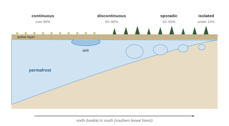
Unfrozen zones within or beneath permafrost are called taliks, and they form under lakes and rivers that do not freeze to the bottom. Ground ice is the key to permafrost's sensitivity. Ice-rich permafrost contains lenses, veins and wedges of nearly pure ice, sometimes more ice than soil by volume. When it thaws, the ground subsides, forming thermokarst: collapse scars in peat plateaus, slumping hillsides, thaw lakes and hummocky terrain. Permafrost temperature has risen across the Arctic over recent decades, often by more than 1 °C at monitored boreholes where the permafrost is coldest, and in the discontinuous zone it is close to 0 °C, poised to thaw.
In Alaska, permafrost underlies nearly all of the North Slope and much of interior and western Alaska, from the continuous permafrost of the Arctic coastal plain to the discontinuous permafrost around Fairbanks, where north-facing slopes and valley bottoms are frozen while south slopes are not. The Trans-Alaska Pipeline, completed in 1977, carries warm oil above ground on vertical supports with heat pipes in permafrost sections so that it does not thaw the ground beneath it, and roads and buildings across interior Alaska show the heaving and sinking that thaw causes.
The thickness of the active layer depends on how much heat reaches the ground in summer and how well the surface insulates. Peat, moss and snow are powerful insulators: a thick moss layer keeps soils cold in summer, whereas deep snow keeps them warm in winter by blocking the cold air. A simple and widely used model, the Stefan equation, predicts the depth of seasonal thaw from the accumulated thawing degree-days and the thermal properties of the soil.
Here \(Z\) is thaw depth in meters, \(k\) the thermal conductivity of the thawed soil in watts per meter per kelvin, TDD the thawing degree-days in degree-days (multiplied by 86,400 seconds per day), \(L\) the latent heat of fusion of water (334,000 joules per kilogram), \(\rho\) the density of water and \(w\) the volumetric water content. In practice an empirical edaphic factor replaces the constants, and depth scales with the square root of thawing degree-days, so doubling summer warmth deepens thaw by about 40 percent, not 100 percent.
# Active layer depth from thawing degree-days with the Stefan equation (synthetic sites).
import numpy as np
L_f, rho_w = 334_000.0, 1000.0                     # J/kg, kg/m3
sites = {                                          # thermal conductivity (W/m/K), volumetric water content
    'mineral soil, thin moss':   (1.2, 0.30),
    'peat plateau, thick moss':  (0.45, 0.55),
    'burned peat, moss removed': (0.6, 0.45),
}
for tdd in (900, 1200, 1500):
    print(f"thawing degree-days = {tdd}")
    for name, (k, w) in sites.items():
        z = np.sqrt(2 * k * tdd * 86400 / (L_f * rho_w * w))
        print(f"   {name:<28} thaw depth {z:4.2f} m")
z1 = np.sqrt(2 * 0.45 * 900 * 86400 / (L_f * 1000 * 0.55)); z2 = np.sqrt(2 * 0.45 * 1800 * 86400 / (L_f * 1000 * 0.55))
print(f"doubling degree-days from 900 to 1800 deepens peat thaw by {100 * (z2 / z1 - 1):.0f} per cent")thawing degree-days = 900 mineral soil, thin moss thaw depth 1.36 m peat plateau, thick moss thaw depth 0.62 m burned peat, moss removed thaw depth 0.79 m thawing degree-days = 1200 mineral soil, thin moss thaw depth 1.58 m peat plateau, thick moss thaw depth 0.71 m burned peat, moss removed thaw depth 0.91 m thawing degree-days = 1500 mineral soil, thin moss thaw depth 1.76 m peat plateau, thick moss thaw depth 0.80 m burned peat, moss removed thaw depth 1.02 m doubling degree-days from 900 to 1800 deepens peat thaw by 41 percent
The output shows why peat plateaus can hold permafrost far south of where mineral soils would: low conductivity and high water content slow heat flow, so thaw stays shallow. It also shows the danger of losing that insulation. Burned peat with its moss gone thaws markedly deeper under the same summer, and once the active layer no longer refreezes completely, a talik forms and thaw accelerates.
Soil carbon and permafrost carbon
Because decomposition is slow and permafrost freezes organic matter in place, northern soils hold enormous stocks of carbon. The northern circumpolar permafrost region is estimated to contain roughly 1,400 to 1,600 billion metric tons of organic carbon, about twice the carbon now in the atmosphere, much of it in the top three meters and in deep, ice-rich deposits called yedoma in Siberia and Alaska. A soil carbon stock is calculated by multiplying, layer by layer, the layer thickness by its bulk density and its carbon fraction, then summing.
Worked problem
Calculating a soil carbon stock
Kai cores a peat plateau and measures two layers: 0 to 0.4 m with bulk density 0.08 g per cm3 and 45 percent carbon, and 0.4 to 1.4 m with bulk density 0.12 g per cm3 and 48 percent carbon. Estimate the carbon stock in kilograms per square meter.
Show solution
- Convert bulk density to kilograms per cubic meter: 0.08 g/cm3 = 80 kg/m3 and 0.12 g/cm3 = 120 kg/m3.
- Top layer: 0.4 m x 80 kg/m3 x 0.45 = 14.4 kg C per m2.
- Lower layer: 1.0 m x 120 kg/m3 x 0.48 = 57.6 kg C per m2.
- Total = 14.4 + 57.6 = 72 kg C per m2, which is 720 metric tons per hectare.
Answer: About 72 kg of carbon per square meter (720 t/ha), far more than the carbon in the trees above it.
By comparison, a mature black spruce stand might hold 30 to 60 metric tons of carbon per hectare in its trees. Ecosystem carbon in the boreal forest is therefore dominated by what is underground, and processes that expose or thaw that carbon, deep-burning fires, drainage and permafrost thaw, matter more for the carbon balance than changes in tree cover alone. Lesson 11 develops the permafrost carbon feedback that results.
Common mistakes
MistakeTreating all boreal conifers as fire-adapted in the same way.
InsteadJack pine and black spruce depend on serotinous cones, while white spruce and balsam fir are fire-sensitive.
MistakeThinking permafrost means ice everywhere below the surface.
InsteadPermafrost is defined by temperature; its ice content varies, and ice-rich permafrost is the kind that subsides when it thaws.
MistakeAssuming active layer thickness scales directly with summer warmth.
InsteadIn the Stefan model thaw depth scales with the square root of thawing degree-days.
MistakeOverlooking mosses and lichens as minor plants.
InsteadThe moss layer insulates permafrost, stores nitrogen and fixes it through cyanobacteria.
MistakeCalculating soil carbon from carbon content alone.
InsteadA stock needs layer thickness and bulk density as well as carbon fraction.
Summary and key terms
- A few tree species dominate, each with a strategy: serotiny in black spruce and jack pine, suckering in aspen, shade tolerance in balsam fir.
- Mosses and lichens insulate soils, store nutrients and shape the ground thermal regime.
- Boreal soils include podzols on uplands, gleysols and organic soils in lowlands and cryosols over permafrost.
- Permafrost is ground below 0 °C for two or more years; zones run from continuous to isolated.
- Ice-rich permafrost subsides when it thaws, creating thermokarst; the Stefan equation predicts thaw depth from degree-days.
- Northern soils and permafrost hold roughly twice the carbon of the atmosphere.
- serotiny
- Retention of seeds in closed cones that open in response to heat, typically from fire.
- root suckering
- Production of new shoots from roots, which lets aspen form large clones.
- podzol
- An acidic, leached upland soil with a bleached layer above a layer enriched in iron, aluminum and organic matter.
- cryosol
- A soil with permafrost near the surface, often mixed by frost action.
- permafrost
- Ground that remains at or below 0 °C for at least two consecutive years.
- active layer
- The surface layer above permafrost that thaws each summer and refreezes each winter.
- talik
- An unfrozen zone within or beneath permafrost.
- thermokarst
- Uneven terrain and collapse features formed when ice-rich permafrost thaws.
- thawing degree-days
- The sum of daily mean temperatures above 0 °C over the thaw season.
- bulk density
- The dry mass of soil per unit volume, used to convert concentrations to stocks.
Practice problems
Work each problem on paper first, then reveal the answer to check.
Why do jack pine stands often consist of trees of a single age?
Show answer
Serotinous cones release seed after fire, so the stand establishes as one post-fire cohort.
Which boreal tree increases in the understorey during long fire-free periods in the east?
Show answer
Balsam fir.
Define continuous permafrost.
Show answer
Permafrost underlying more than 90 percent of the landscape.
A site has 1,000 thawing degree-days and a thaw depth of 0.6 m. Using square-root scaling, predict thaw depth at 1,440 degree-days.
Show answer
0.6 x sqrt(1.44) = 0.72 m.
Why does a severe fire that burns the moss layer deepen the active layer?
Show answer
It removes insulation and darkens the surface, so more heat reaches the soil.
What soil horizon color marks a podzol?
Show answer
A bleached gray eluvial layer over a rust-colored layer of accumulation.
A layer 0.5 m thick has bulk density 100 kg/m3 and 40 percent carbon. What is its carbon stock?
Show answer
0.5 x 100 x 0.40 = 20 kg C per m2.
What is yedoma?
Show answer
Very ice-rich, carbon-rich permafrost deposits found in Siberia and Alaska.
Lesson quiz · 5 questions
Score 60% or more to complete this lesson.
Create a free account to save your progress, take quizzes and earn a certificate.