
BIOL-440 · Lesson 12 of 12 · 23 min
Capstone: a management plan for an invented boreal region
This capstone brings the course together. The Sable River team has been asked to help a joint planning board draft a 50-year ecological management plan for the watershed around their station and the caribou range to its north. The board brings together the local Indigenous government, the provincial, territorial or state government, a forestry company, an energy company that holds exploration rights, and the station's scientists. The task is to describe the system, identify what people value in it, project how it might change under different choices, and propose management that is robust to an uncertain future. Every number here is synthetic, but the reasoning is the kind used in real northern planning.
The planning area
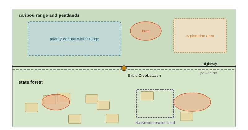
The planning area covers 6,000 square kilometers (about 2,300 square miles) of the invented Sable Creek watershed in interior Alaska: black spruce over permafrost on north slopes and lowlands, aspen, birch and white spruce on south slopes, fens and bogs over 30 percent of the area, and many lakes. The northern 3,500 square kilometers overlap the winter range of a migratory caribou herd and the range of a small resident woodland herd. State forest land covers the southern half, a highway and powerline run east–west across the middle, and an energy company holds exploration leases in the northeast. Alaska Native village and regional corporations own several large parcels, and village residents hunt, trap and fish across the area under state and federal subsistence regulations. The plan must coordinate state, federal and Native corporation landowners, which in Alaska is often the hardest part of landscape planning.
Step 1: what matters
Planning starts with values, not models. Through workshops and interviews, the board identified valued components: a self-sustaining caribou population; moose, fish and furbearers for harvest; clean water and healthy fish; peatland and forest carbon; a sustainable timber supply and local jobs; safety of the community and infrastructure from wildfire; cultural sites and travel routes; and room for economic development. Each valued component needs an indicator that can be measured and projected, and a target or threshold that signals concern. Some targets come from law or science, such as the 65 percent undisturbed habitat threshold for boreal caribou; others are set by the board, such as maintaining at least 20 percent of the forest older than 120 years.
| Valued component | Indicator | Target or threshold | Main pressures |
|---|---|---|---|
| Caribou | Undisturbed share of range; calves per 100 cows | ≥ 65% undisturbed; ≥ 28 calves per 100 cows | Fire, linear features, harvest, predation |
| Old forest | Share of forest older than 120 years | ≥ 20% of forested area | Fire, harvest |
| Moose and furbearers | Harvest success; track counts | Stable or rising | Access, predation, habitat change |
| Fish and water | Mercury in pike; water quality | Below consumption guideline | Development, permafrost thaw |
| Carbon | Peatland area intact; forest carbon | No net loss of intact peatland | Drainage, roads, deep burning |
| Community safety | Fuel treatment around town; evacuation plans | Treatment of high-risk interface | More extreme fire weather |
| Timber and jobs | Annual harvest volume | Sustainable over 100 years | Fire losses, protected areas |
Step 2: the current state
The team assembled the evidence. Fire history from lesson 4 gives a fire cycle of roughly 85 to 90 years under recent climate. The stand-age map shows 34 percent of the forest older than 120 years. In the caribou range, burns under 40 years old cover 18 percent and human features buffered by 500 meters cover 24 percent, with some overlap, so total disturbance is about 39 percent and the undisturbed share about 61 percent, just below the threshold. Collared caribou show adult female survival of 0.88 and recruitment of 25 calves per 100 cows, a slowly declining population with a growth rate of about 0.99. Peatlands store an average of about 150 kilograms of carbon per square meter, and permafrost persists only in scattered peat plateaus, which have shrunk over the past 50 years. Guardians report that moose have increased near the road and that wolves now use the seismic lines in winter.
Step 3: scenarios
The future is uncertain, so the team projected the system under alternative management options and climate futures, rather than trying to predict a single outcome. Three management options were defined. Business as usual continues current harvest and allows exploration to proceed with standard mitigation. Conservation focus protects the northern peatlands and caribou range from new industrial disturbance, restores 1,500 kilometers of seismic lines over 20 years and concentrates harvest in the south. Balanced uses designated zones for development with strict limits on new linear features, restores half as many lines and reduces harvest in the caribou range. Each option was run under a moderate and a hot climate future, the latter with more frequent fire.
# 50-year scenario model for the Sable caribou range (synthetic, illustrative).
import numpy as np
def project(option, climate, runs=400, years=50, seed=1212):
    rng = np.random.default_rng(seed)
    fire_rate = {'moderate': 0.0045, 'hot': 0.012}[climate]          # fraction of range burning per year
    new_dist = {'business as usual': 0.006, 'balanced': 0.0015, 'conservation': 0.0}[option]
    restore = {'business as usual': 0.0, 'balanced': 0.003, 'conservation': 0.006}[option]
    out = []
    for _ in range(runs):
        burned, human = 0.18, 0.24                                  # starting disturbed shares (with overlap below)
        for t in range(years):
            fire = rng.gamma(0.3, fire_rate / 0.3)                    # variable annual area burned
            burned = min(burned + fire * (1 - burned) - burned / 40, 0.95)   # burns recover after ~40 years
            human = max(human + new_dist - (restore if t < 20 else 0), 0.05)
        total = 1 - (1 - burned) * (1 - human)
        recruit = 36 - 0.24 * 100 * total                            # calves per 100 cows (lesson 7 relationship)
        lam = 0.88 + 0.5 * recruit / 100 * 0.88                     # female survival plus female recruits
        out.append((total, lam))
    a = np.array(out)
    return a[:, 0].mean(), np.mean(a[:, 0] <= 0.35), np.median(a[:, 1]), np.mean(a[:, 1] >= 1.0)
print(f"{'option':<18}{'climate':<10}{'disturbed':>10}{'P(meets 65%)':>14}{'lambda':>8}{'P(lambda>=1)':>14}")
for opt in ('business as usual', 'balanced', 'conservation'):
    for clim in ('moderate', 'hot'):
        d, p, l, pl = project(opt, clim)
print(f"{opt:<18}{clim:<10}{100 * d:>9.0f}%{p:>14.2f}{l:>8.3f}{pl:>14.2f}")option climate disturbed P(meets 65%) lambda P(lambda>=1) business as usual moderate 61% 0.00 0.974 0.00 business as usual hot 68% 0.00 0.967 0.00 balanced moderate 37% 0.10 0.999 0.33 balanced hot 48% 0.00 0.987 0.00 conservation moderate 26% 1.00 1.011 1.00 conservation hot 39% 0.21 0.997 0.33
The projections show the logic of robust decision-making. Under business as usual, disturbance rises well above the threshold in both climates and the caribou population almost certainly declines. Conservation focus brings disturbance well below the threshold under a moderate climate and gives a stable or growing herd in nearly every run, but in the hot future it meets the threshold in only about a fifth of runs and gives a stable herd in about a third, because fire alone pushes disturbance up. The balanced option sits between them, failing the threshold in most runs even under a moderate climate. No option guarantees success under the hot climate, which tells the board two things: managing human disturbance is necessary but not sufficient, and the plan must include actions for fire, such as protecting key lichen winter ranges where feasible, and monitoring that would trigger further action.
Trade-offs must be made explicit. The conservation option reduces the timber available from the northern half of the license and defers some exploration, with costs to jobs and revenue that the board must weigh, perhaps offset by restoration employment, guardian programs and carbon finance for protected peatlands. Uncertainty must be communicated honestly: the projections rest on a disturbance–recruitment relationship borrowed from other ranges, on assumed fire rates and on a highly simplified population model. The team therefore presented ranges and probabilities rather than single numbers, ran the model again with different fire rates and recruitment slopes to check whether the ranking of options changed, and explained the limits of the model in plain language at community meetings, alongside the guardians' observations of the same landscape.
Step 4: the plan
Drawing on the projections, the board's draft plan combines measures across the course. It protects the northern peatlands and core caribou range from new industrial disturbance, consistent with the proposed Indigenous protected area; restores seismic lines in the caribou range by mounding, planting and line blocking, prioritizing lines that wolves use most according to collar data; and concentrates harvest in the south using natural disturbance-based patterns that retain old-forest patches and snags. It sets a cap on new linear features and requires shared roads and narrow, low-impact seismic methods in the development zone. For fire, it supports FireSmart or Firewise treatments around the community and infrastructure, revives cultural burning in spring around the community with the Indigenous government's fire program, and designates priority caribou winter range for initial attack when fires threaten it. For fish and water, it requires baseline and ongoing mercury monitoring before any new impoundment or road crossing, and for carbon it adopts no net loss of intact peatland.
Implementation depends on the state forest plan and permitting, the cooperation of Native corporations as major landowners, federal agencies for subsistence and migratory caribou management, and agreements with the energy leaseholder. Tribal councils and the regional caribou working group would share in monitoring and in setting harvest recommendations, and federal and state fire agencies would assign protection levels consistent with the plan's priorities.
Step 5: monitoring and adaptive management
The plan is adaptive: it treats management as an experiment, monitors outcomes and adjusts. The monitoring program follows the design principles of BIOL-430. Satellite imagery tracks disturbance and fire annually; guardians and scientists jointly survey caribou recruitment each March and collar a sample of cows; wolf collars and trail cameras on restored and unrestored lines test whether restoration reduces wolf use, using a before–after–control–impact design; stand plots track regeneration after fire and harvest; permafrost and peatland plots track thaw; and fish mercury is sampled every three years. The board agreed on triggers in advance: if recruitment stays below 25 calves per 100 cows for three consecutive years, or disturbance exceeds 45 percent, the board will consider further measures, such as maternal penning or temporary harvest closures. Data are shared under agreed governance principles, OCAP or CARE, with results reported to the community each year.
Worked problem
Choosing among options with a risk threshold
The board agreed that an acceptable option must give at least a 50 percent chance of a stable or growing caribou population under the moderate climate, and that among acceptable options it will choose the one with the highest chance under the hot climate. The projections give probabilities of lambda of at least 1 of 0.00 (moderate) and 0.00 (hot) for business as usual, 0.33 and 0.00 for balanced, and 1.00 and 0.33 for conservation. Which option is chosen, and what does the result imply for the plan?
Show solution
- Check the first criterion under the moderate climate: business as usual (0.00) and balanced (0.33) fall below 0.50; conservation (1.00) passes.
- Only conservation is acceptable, so it is chosen.
- Even so, conservation gives only a one-in-three chance under the hot climate, so the plan must add fire-related measures and monitoring triggers.
- The result depends on the model and its assumptions, so the board should also test how sensitive the ranking is to the disturbance–recruitment relationship and the fire rates.
Answer: The conservation option, the only one meeting the 50 percent criterion, supplemented with fire measures because its hot-climate odds remain about one in three.
Common mistakes
MistakeStarting with a model instead of with values.
InsteadIdentify valued components, indicators and targets with the people who live there before projecting.
MistakeSeeking a single optimal prediction.
InsteadUse scenarios across climate futures and choose robust options.
MistakeAssuming habitat protection alone will secure caribou in a hotter climate.
InsteadFire may push disturbance up regardless, so plans need fire measures and triggers for further action.
MistakeSetting monitoring without decision triggers.
InsteadAgree in advance which results will prompt which actions.
MistakeTreating Indigenous partners as stakeholders to consult late.
InsteadIndigenous governments are rights holders and decision-makers from the start.
Summary and key terms
- Planning starts with valued components, indicators and targets agreed with the people who live in and govern the area.
- The current state is assembled from fire history, stand ages, disturbance mapping, wildlife vital rates and community observations.
- Scenario models compare management options across climate futures to find robust choices.
- A plan combines protection, restoration, careful harvest, fire management and monitoring.
- Implementation depends on governance: Crown or state agencies, Indigenous governments and landowners.
- Adaptive management uses monitoring with pre-agreed triggers and shared data governance.
- valued component
- An element of the environment that people care about and that a plan aims to protect.
- indicator
- A measurable variable that tracks the condition of a valued component.
- threshold
- An indicator value beyond which risk of harm increases sharply.
- scenario
- A plausible, internally consistent description of a possible future used for planning.
- robust decision
- A choice that performs acceptably across a wide range of possible futures.
- adaptive management
- Management that treats actions as experiments, monitors outcomes and adjusts.
- decision trigger
- A pre-agreed monitoring result that prompts a specific management response.
- rights holder
- A party with legal or constitutional rights in an area, such as an Indigenous government.
- initial attack
- The first suppression response to a new fire.
- no net loss
- A policy that any loss of a habitat must be balanced by equivalent gains.
Practice problems
Work each problem on paper first, then reveal the answer to check.
Why does the planning process begin with valued components?
Show answer
So that projections and decisions address what people actually care about in the area.
A range is 39 percent disturbed. Does it meet the federal threshold?
Show answer
No; it is 61 percent undisturbed, below 65 percent.
Why model several climate futures?
Show answer
Because the future is uncertain; robust options must perform acceptably across plausible futures.
In the scenarios, why does even the conservation option struggle under a hot climate?
Show answer
More frequent fire raises disturbance regardless of human activity.
Name two fire-related measures in the plan.
Show answer
For example FireSmart treatments, cultural burning, or prioritizing caribou winter range for initial attack.
What is a decision trigger? Give an example from the plan.
Show answer
A pre-agreed result that prompts action, such as recruitment below 25 calves per 100 cows for three years.
Why use a BACI design to evaluate line restoration?
Show answer
To separate the effect of restoration from changes that would have happened anyway.
Who must be involved in implementing the plan?
Show answer
Crown or state agencies, the Indigenous government, landowners and companies.
Lesson quiz · 5 questions
Score 60% or more to complete this lesson.
Create a free account to save your progress, take quizzes and earn a certificate.