
ARCH-450 · Lesson 4 of 12 · 23 min
Documenting historic buildings
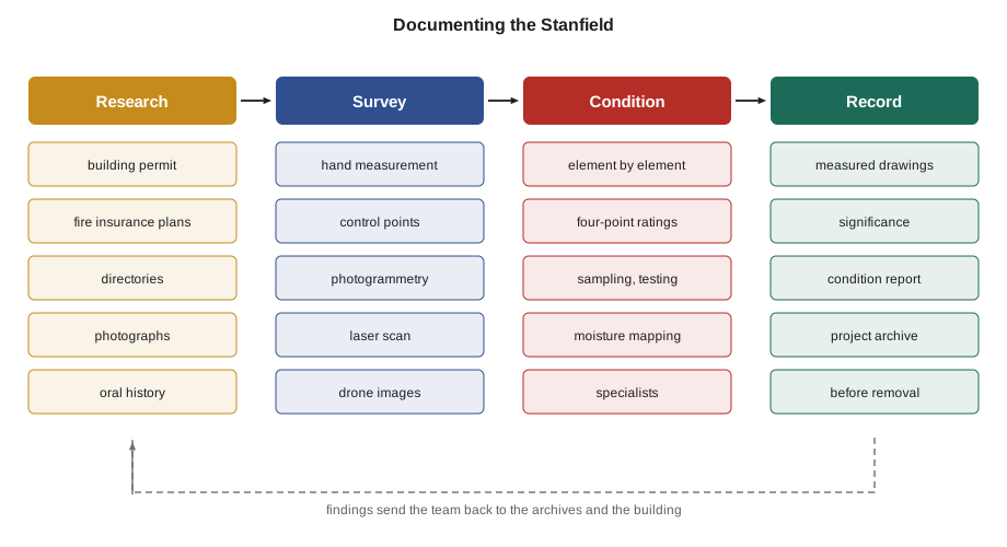
In the fourth week the studio moves into the Stanfield. The owner has agreed to let the students set up tables on the ground floor, under temporary lights strung from the beams, and Bérubé divides the work. Wren and Joon-ho will research the building's history in the archives. Callum and Ingrid will measure it. Everyone will take part in the condition survey. 'You cannot conserve what you do not understand,' Bérubé says, 'and you cannot understand what you have not recorded. Documentation is not paperwork that comes before the design. It is the first act of design, and the record you make now may be the only record of this building that survives.'
Why document
Documentation serves several purposes at once. It establishes what the building is and how it got that way, which is the evidence for the statement of significance. It records the condition of every element, which is the basis for deciding what to repair and what to replace. It provides accurate drawings for the design and for the contract documents, because old buildings are rarely square, rarely plumb and almost never match whatever drawings survive. It creates a permanent record of the building before it is changed, so that future owners, researchers and architects know what was there. And it often reveals things that change the design: a blocked-up window, a hidden cast-iron column, a painted ceiling under a later layer of plaster or a structural defect that no one suspected.
Bérubé insists on one rule above all: record before you remove. Once a partition is demolished or a layer of paint is stripped, the evidence it contained is gone. The students will photograph every room before anyone moves a piece of furniture, and they will record every element that the design proposes to remove before it is removed.
Archival research
Wren and Joon-ho begin in the archives. The Hennepin County Library's Special Collections and the city's records hold the building permit for the Stanfield, issued in 1910, which gives the name of the architect, the contractor, the estimated cost and a short description. The permit lists the building as a five-story warehouse of brick and mill construction. The original drawings have not survived, a common situation, but the permit led them to the architect's name, and the architect's name led them to a set of drawings for a similar warehouse two blocks away, which shows the details the Stanfield probably shares.
Fire insurance plans are one of the most valuable sources for commercial buildings. Insurance companies mapped cities in great detail between the 1870s and the 1950s, recording every building's footprint, height, construction, roof, openings, fire walls and use with a set of standard symbols and tints, and revising the maps as buildings changed. The Sanborn maps, which cover thousands of American towns and cities, show the Stanfield in several editions. The 1917 sheet confirms the brick walls, the timber interior, a freight elevator and an iron fire escape on the lane; a 1949 revision shows a one-story addition on the lane, since demolished.
City directories list who occupied each address year by year, and from them the students trace the Stanfield's history: the implement company until 1932, a wholesale hardware firm until 1961, a printing company on the lower floors and a mix of small manufacturers above, artists' studios on the upper floors from the late 1970s to the early 2000s, and vacancy since 2009. Historic photographs from the archives and from the collections of local historical societies show the building in 1912 with its full cornice and original storefront, in the 1950s with a large painted sign on the avenue facade, and in the 1980s with artists' work in the windows. Newspaper articles record a fire on the fourth floor in 1938, which explains why a group of beams on that floor are newer than the rest.
Oral history fills gaps that documents cannot. The students interview a retired printer who worked in the building in the 1970s and two artists who had studios on the fifth floor. They learn where the original stair was, why one bay of windows was bricked up (to protect stored paper from light) and that the freight elevator was still hand-operated in 1985. These memories are evidence of social value as well as history, and the interviews are recorded and transcribed for the project archive.
The measured survey
Callum and Ingrid start with the simplest tools: tape measures, a laser distance meter, a level and a notebook. They measure each floor along the lines of posts, recording the spacing of the bays, the thickness of the walls at each opening, the sizes of posts and beams, and the heights of floors and windows. They draw as they measure, on gridded paper at a scale large enough to note every dimension, because a dimension without a sketch is useless and a sketch without dimensions is dangerous. Bérubé shows them how to take running dimensions from a single starting point along each wall, so that errors do not accumulate, and how to take diagonals across each room to check whether it is square. Few rooms in the Stanfield are: the building is about 2 1/2 in wider at the lane than at the avenue.
Brick coursing is a useful check on vertical dimensions. The Stanfield's brick, with its mortar joints, rises at almost exactly a constant height for every course, so the students can count courses on a photograph and convert the count to a height. This lets them estimate the heights of parts of the facade they cannot reach, and check the heights they have measured.
# Estimating heights on the Stanfield's facade by counting brick courses
# Calibrate: measured height of 10 courses at the ground floor
ten_courses_in = 28.0
course = ten_courses_in / 10
print(f"one course = {course:.2f} in (brick plus joint)")
counts = {"sill of level 2 windows": 62, "top of level 3 arches": 157,
          "base of cornice": 286, "top of parapet": 301}
for item, n in counts.items():
    print(f"{item:<26} {n:>4} courses = {n * course / 12:6.1f} ft")
# Check against the laser measurement of the cornice base from the sidewalk
laser_ft = 66.6
est = counts["base of cornice"] * course / 12
print(f"laser {laser_ft:.1f} ft, estimate {est:.1f} ft, difference {abs(laser_ft - est) * 12:.1f} in")one course = 2.80 in (brick plus joint) sill of level 2 windows 62 courses = 14.5 ft top of level 3 arches 157 courses = 36.6 ft base of cornice 286 courses = 66.7 ft top of parapet 301 courses = 70.2 ft laser 66.6 ft, estimate 66.7 ft, difference 1.6 in
The estimate agrees with the laser measurement to within a few inches, which tells the students both that their course count is right and that the facade has not settled unevenly. Where the two disagree on an old building, the difference is itself evidence, of a lintel that has dropped, a wall that has bulged or a parapet that has been rebuilt.
Photogrammetry and laser scanning
Hand measurement is accurate and teaches the measurer a great deal about the building, but it is slow, and it cannot easily capture curved or decorated surfaces. For the facades and the complex details, the students use two digital methods. Photogrammetry builds a three-dimensional model or a scaled, distortion-free image, called an orthophoto, from many overlapping photographs taken from different positions. With a scale reference and a few control points measured by hand or with a total station, it produces elevations accurate enough for drawings at the scale of the facade. The students photograph the avenue facade from the sidewalk and from the windows across the street, and a drone flight, arranged by the owner, captures the parapet and the cornice.
Laser scanning measures millions of points by sweeping a laser across every surface within its range, producing a point cloud that records the geometry of a building to within a few hundredths of an inch over large distances. A consultant scans the whole interior in two days, setting up the scanner at about forty positions and registering the scans together. The point cloud reveals what hand measurement missed: the floors sag between posts by up to 1 1/2 in on the fourth floor, the avenue wall leans outward by 1 in over its height, and the posts are not exactly on a grid. The cloud is not a drawing, however. Someone must still decide what to draw, interpret what the points show, and build a model or a set of drawings that a builder can use. Bérubé insists that the students walk the building with the scan on a tablet, checking it against what they can see and touch.
Measured drawings and recording standards
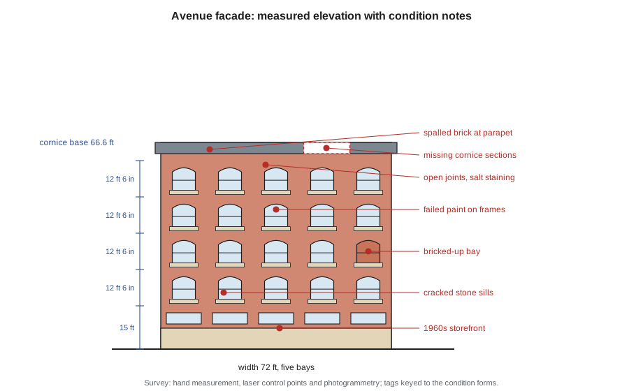
Measured drawings of historic buildings follow conventions set by the Historic American Buildings Survey, established in 1933 as a program to employ architects during the Depression, and now part of the National Park Service with its companion programs for engineering and landscapes. Its standards define how buildings are recorded in drawings, large-format photographs and written history, and its collection, held at the Library of Congress, is one of the great archives of American architecture. The students' drawings will show the building as it exists, not as it was designed or as it should be. They distinguish original fabric from later work, note materials and conditions, and give the sources and methods of measurement on each sheet.
The condition survey
A condition survey records the state of every element of the building, so that the design and the cost plan rest on facts rather than guesses. The students work through the building systematically, floor by floor and elevation by elevation, using a standard form. For each element they record its location, material, original or later date, condition, the likely cause of any deterioration and the urgency of repair. They use a simple scale of four ratings: good, fair, poor and failed, with clear definitions of each so that different people rate the same element in the same way. Every rating is backed by a photograph keyed to the drawings.
Some conditions can be judged by eye. Others need investigation. A few bricks are removed from the parapet to see how far the deterioration goes. Mortar samples are taken for laboratory analysis, to find out what the original mortar was made of so that repairs can match it. A moisture meter maps damp areas on the inside of the walls, and the students find that the north-east corner of the fifth floor is wet, below a roof drain that has been blocked for years. A structural engineer bores small holes into the beam ends at the fifth floor and finds rot in four of them, where they sit in pockets in the wet wall. Paint samples are examined under a microscope to find the original paint scheme of the windows, a dark green under six later layers. The survey also records hazards: lead in the old paint, asbestos in the pipe insulation of the 1950s heating system and pigeon droppings on the top floor, all of which need specialist handling before the work begins.
# Summarizing the Stanfield condition survey
import collections
survey = [
    ("parapet brick", "poor"), ("cornice metal", "poor"), ("upper walls", "fair"),
    ("lower walls", "fair"), ("stone base", "good"), ("stone sills", "fair"),
    ("windows level 2", "poor"), ("windows levels 3-5", "fair"), ("storefront", "poor"),
    ("roof membrane", "failed"), ("roof drains", "failed"), ("posts", "good"),
    ("beams levels 2-4", "good"), ("beam ends level 5 NE", "failed"), ("plank floors", "good"),
    ("freight elevator", "poor"), ("fire escape", "failed"), ("interior plaster", "fair"),
]
rank = {"good": 0, "fair": 1, "poor": 2, "failed": 3}
count = collections.Counter(c for _, c in survey)
for k in rank:
    print(f"{k:<7} {count[k]:2d}")
urgent = [e for e, c in survey if rank[c] == 3]
print("urgent (stabilize first):", ", ".join(urgent))good 4 fair 5 poor 5 failed 4 urgent (stabilize first): roof membrane, roof drains, beam ends level 5 NE, fire escape
The summary gives the owner the most important finding of the survey in one line: the roof and its drains have failed, and water is reaching the structure. Bérubé recommends that the roof be patched and the drains cleared immediately, months before any design is approved, and that the wet beam ends be propped. This is preservation in its plainest form, and the standards require it: a historic place must be protected and stabilized until a use is found, because an empty building that leaks can lose in a few years what a century of use did not harm.
Bringing it together
By the end of the week the students have the materials for a conservation plan: a history of the building, a set of measured drawings, a condition report and a revised statement of significance. The research has changed their understanding of the building in several ways. The fourth-floor beams replaced after the 1938 fire are now understood as part of the building's history, not as original fabric. The bricked-up bay is a later change that may be reversed. The mezzanine added in the 1930s, about which they were unsure in the first week, turns out to have been built by the hardware company for its offices and is finished with the only surviving decorative woodwork in the building. It moves into the list of character-defining elements. Documentation has done what Bérubé promised: it has turned instinct into evidence.
Worked problem
Planning a condition survey
The Stanfield has five floors and a basement, four elevations and a roof. Plan how two people can complete a first condition survey in three days, and list the specialists who must be called in.
Show solution
- Day 1: roof and exterior elevations, using binoculars, the drone images and the windows for access; note the parapet, cornice, walls, windows, storefront and fire escape.
- Day 2: the interior, floor by floor, recording structure, floors, walls, windows from inside, the elevator and services; map moisture with a meter.
- Day 3: the basement and foundations, sampling of mortar and paint, photographs to fill gaps, and compilation of the forms.
- Specialists: a structural engineer for the beam ends, the wall lean and the floor sag; a hazardous materials consultant for lead and asbestos; a masonry conservator for mortar analysis; an elevator inspector.
Answer: Two people can make a systematic first survey in three days if they divide it by zone, but the structural, hazardous materials and masonry findings must come from specialists.
Exercise 4: recording a historic building
- Find the building permit, a fire insurance plan and two historic photographs for a building near the school, and write a one-page history.
- Measure a room by hand, taking running dimensions and diagonals, and draw it at a scale of 1:50 or 1/4 in = 1 ft.
- Estimate the height of a brick facade by counting courses, and check it against a laser measurement.
- Survey the condition of one elevation using the four-point scale, and photograph each element you rate.
Self-check
- Have I recorded before removing anything?
- Have I drawn the building as it exists, distinguishing original fabric from later work?
- Have I backed every condition rating with a photograph and a likely cause?
- Have I identified the urgent problems that need stabilizing now?
Common mistakes
MistakeRelying on surviving original drawings as a record of the building.
InsteadMeasure the building as built, because buildings rarely match their drawings and change over time.
MistakeTreating a point cloud as finished documentation.
InsteadInterpret the scan, check it in the building and produce drawings or a model that show what matters.
MistakeRating condition without a clear scale.
InsteadUse defined ratings so different people rate elements consistently, and back each with a photograph.
MistakeWaiting for design approval before stopping water entry.
InsteadStabilize urgent problems such as roof leaks immediately.
MistakeIgnoring later changes in the history.
InsteadRecord and evaluate later work, since some of it may have significance of its own.
Summary and key terms
- Documentation establishes what a building is, how it changed and what condition it is in, and is the first act of conservation design.
- Archival sources include building permits, fire insurance plans, directories, photographs, newspapers and oral history.
- Measured surveys combine hand measurement with total stations, photogrammetry and laser scanning, but scans must be interpreted.
- Condition surveys rate every element on a defined scale, identify causes and call in specialists for structure, hazards and materials.
- Urgent problems such as water entry must be stabilized at once, and everything must be recorded before it is removed.
- Fire insurance plan
- A detailed map made for insurers showing each building's footprint, construction, height and use.
- Photogrammetry
- The production of measured models or scaled images from overlapping photographs.
- Point cloud
- A set of millions of measured points produced by laser scanning.
- Orthophoto
- A photograph corrected for distortion so that it can be measured at a uniform scale.
- Condition survey
- A systematic record of the state of every element of a building, with ratings and causes.
Practice problems
Work each problem on paper first, then reveal the answer to check.
Name three archival sources that helped the students date changes to the Stanfield.
Show answer
The building permit, fire insurance plans, city directories, historic photographs and newspaper articles.
Why take running dimensions from a single starting point?
Show answer
So that small errors do not accumulate along a wall.
Ten brick courses measure 28 in. How high is a point 200 courses above the base?
Show answer
About 46.7 ft.
What did the laser scan reveal that hand measurement missed?
Show answer
Floor sag of up to about 1 1/2 in, an outward lean of the avenue wall and posts that are not exactly on a grid.
Why must the roof be repaired before the design is approved?
Show answer
Water is reaching the structure, and the standards require a place to be protected and stabilized until a use is found.
Lesson quiz · 5 questions
Score 60% or more to complete this lesson.
Create a free account to save your progress, take quizzes and earn a certificate.