
MSAZ-300 · Lesson 7 of 12 · 21 min
Graph and spatial data
▶ Video coming soon A video version of this lesson is on the way.
Two features of the new Finch Rewards app needed data that does not sit comfortably in rows and columns. The refer-a-friend program pays a bonus when a member brings in a new member, and a smaller bonus when that new member brings in someone else, up to three levels. Marketing also wants to know which members are at the centre of large referral networks, because those people are worth a thank-you. And the app's store finder must show the nearest stores to wherever the member is standing, with offers from those stores first. The first is a graph problem, the second a spatial one, and SQL Server and Azure SQL have built-in support for both.
Graph tables
A graph is a set of nodes connected by edges. In SQL Server's graph feature, a node table is an ordinary table created AS NODE, which adds a hidden node ID column identifying each node. An edge table is created AS EDGE and adds from and to ID columns that point at nodes, plus an edge ID of its own. In T-SQL these pseudo-columns are written with a leading dollar sign, as the listings show. Edges can have their own columns, such as the date of a referral or the bonus paid. Because they are tables, nodes and edges can have indexes, constraints and permissions like any other table, and graph queries can join them to ordinary tables.
CREATE TABLE graph.Person (MemberId bigint NOT NULL PRIMARY KEY) AS NODE;

CREATE TABLE graph.Referred
(
    ReferredOn date NOT NULL,
    BonusPoints int NOT NULL,
    CONSTRAINT EC_Referred CONNECTION (graph.Person TO graph.Person)
) AS EDGE;

-- Member 1001 referred member 2040 on March 3, 2026
INSERT graph.Referred ($from_id, $to_id, ReferredOn, BonusPoints)
SELECT a.$node_id, b.$node_id, '2026-03-03', 500
FROM graph.Person AS a, graph.Person AS b
WHERE a.MemberId = 1001 AND b.MemberId = 2040;
An edge constraint, written with CONNECTION, limits which node types an edge may join; without one, an edge table can connect any nodes to any nodes. The node and edge ID pseudo-columns are stored as JSON strings that identify the table and row, and the engine fills them in for you.
Graph queries use the MATCH clause, which describes a pattern with an ASCII-art arrow. MATCH(a-(r)->b) means node a has an edge r pointing to node b. Patterns can chain: MATCH(a-(r1)->b-(r2)->c) finds two-step referrals. The direction of the arrow matters, and patterns can point either way. For paths of unknown length, SHORTEST_PATH finds the shortest chain of edges between nodes, with a + for one or more steps or {1,3} for between one and three, and aggregate functions such as COUNT and STRING_AGG with WITHIN GROUP (GRAPH PATH) summarize each path.
-- Members referred by people that member 1001 referred (second level)
SELECT p3.MemberId AS SecondLevel
FROM graph.Person AS p1, graph.Referred AS r1, graph.Person AS p2,
     graph.Referred AS r2, graph.Person AS p3
WHERE MATCH(p1-(r1)->p2-(r2)->p3)
  AND p1.MemberId = 1001;

-- Everyone within three levels of member 1001, with the chain that links them
SELECT p1.MemberId AS Root,
       LAST_VALUE(p2.MemberId) WITHIN GROUP (GRAPH PATH) AS Reached,
       COUNT(p2.MemberId) WITHIN GROUP (GRAPH PATH) AS Levels,
       STRING_AGG(CAST(p2.MemberId AS varchar(20)), ' > ') WITHIN GROUP (GRAPH PATH) AS Chain
FROM graph.Person AS p1,
     graph.Referred FOR PATH AS r,
     graph.Person FOR PATH AS p2
WHERE MATCH(SHORTEST_PATH(p1(-(r)->p2){1,3}))
  AND p1.MemberId = 1001;
Hana compared this with the recursive CTE from lesson 3, which answers the same question from a ReferredBy column on Member. For a strict tree, where everyone has at most one referrer, the CTE is fine and needs no new tables. The graph model earns its place when the relationships are many-to-many or of several kinds. Marketing's next request was exactly that: members can now also share offers with friends and belong to household groups, so one person can be connected to another in three different ways. In the graph model that is two more edge tables and patterns that mix them. In the relational model it is three more self-joining tables and recursive queries that grow harder with every new kind of link.
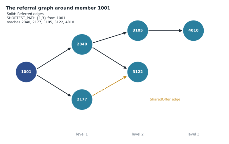
Graph tables do not make every relationship query fast. MATCH patterns are turned into joins, so indexes on the from and to ID columns of each edge table matter just as foreign key indexes do, and SHORTEST_PATH across a very large, densely connected graph can be expensive. For the referral program, which has about 38,000 referral edges, the three-level query runs in a few milliseconds with indexes on both edge columns.
Spatial data
SQL Server has two spatial types. geography stores shapes on the round Earth, using latitude and longitude, and measures distances and areas in real units, by default metres and square metres for the common coordinate system, SRID 4326. geometry stores shapes on a flat plane, in whatever units the coordinates use, which suits floor plans, maps already projected to a flat grid, and the warehouse layout in StockLine. For anything that has a latitude and longitude, geography is the right choice, because distances on a flat plane drawn from latitude and longitude are wrong, and increasingly so far from the equator.
ALTER TABLE rewards.Store ADD Location geography NULL;

UPDATE rewards.Store
SET Location = geography::Point(49.882, -97.200, 4326)   -- latitude, longitude, SRID
WHERE StoreId = 11;

CREATE SPATIAL INDEX SX_Store_Location ON rewards.Store (Location);
The argument order catches everyone at least once. geography::Point takes latitude, then longitude, then the SRID. Well-known text, used by geography::STGeomFromText and by many other tools, writes POINT(longitude latitude), the other way round. A store placed with its coordinates swapped ends up in the wrong hemisphere, and the error is silent until someone looks at a map. Hana's import checks that every store's latitude is between 40 and 60 and its longitude between −100 and −90, which covers every Harrow & Finch location and catches any swap.
Spatial methods answer the store finder's questions. STDistance returns the distance between two shapes, in metres for geography with SRID 4326. STBuffer draws a zone around a shape, and STIntersects or STWithin test whether shapes overlap or one is inside another, which is how the app will decide whether a member is inside a store's delivery area. A nearest-neighbour query, TOP (n) with ORDER BY STDistance and a WHERE clause that filters out null distances, can use the spatial index.
DECLARE @here geography = geography::Point(49.870, -97.150, 4326);

SELECT TOP (3) s.StoreId, s.StoreName,
       CAST(s.Location.STDistance(@here) / 1000.0 AS decimal(6,1)) AS DistanceKm
FROM rewards.Store AS s
WHERE s.Location.STDistance(@here) IS NOT NULL
ORDER BY s.Location.STDistance(@here);from math import radians, sin, cos, asin, sqrt
def distance_km(lat1, lon1, lat2, lon2):
# great-circle distance on a sphere the size of the Earth
lat1, lon1, lat2, lon2 = map(radians, (lat1, lon1, lat2, lon2))
a = sin((lat2 - lat1) / 2) ** 2 + cos(lat1) * cos(lat2) * sin((lon2 - lon1) / 2) ** 2
return 2 * 6371.0 * asin(sqrt(a))
member = (49.870, -97.150)
stores = {"St. Vital": (49.830, -97.100), "Polo Park": (49.882, -97.200),
"Kildonan": (49.940, -97.080), "Transcona": (49.890, -97.000)}
ranked = sorted((distance_km(*member, *pos), name) for name, pos in stores.items())
for km, name in ranked:
print(f"{name:10s} {km:5.1f} km")
print("nearest store:", ranked[0][1])Polo Park 3.8 km St. Vital 5.7 km Kildonan 9.3 km Transcona 11.0 km nearest store: Polo Park
What this code does
The program takes a member's home location and four store locations as latitude and longitude, and works out the straight-line distance over the Earth's curved surface from the member to each store. It sorts the stores from nearest to farthest and prints the list, then names the nearest one. This is the same calculation the geography type's distance method does in the database, which is why the query in this lesson can rank stores without any of this arithmetic in the app.
| Task | Method | Finch Rewards use |
|---|---|---|
| Distance between two places | STDistance | Rank the nearest stores |
| A zone around a place | STBuffer | Delivery area around a store |
| Is a point inside an area? | STWithin or STIntersects | Is the member inside a delivery zone? |
| Build a point | geography::Point(lat, long, SRID) | Store and member locations |
| Read or write shapes as text | STGeomFromText, STAsText | Import delivery zones from the mapping team |
Privacy
Location is personal information. Carmen Ortiz reviewed the store finder and set two rules. The app sends the member's current position for each search and the database does not store it; the query uses it and forgets it. The member's home location is stored only as the postal or ZIP code centre the member typed, never a precise address. Both rules show up in the design: there is no MemberLocation table, and the search procedure takes the position as a parameter. MSAZ-281 covers masking and access control for the columns that are stored.
Loading and maintaining the graph
Node and edge tables are filled with ordinary INSERT statements, usually from existing relational tables. Hana loaded graph.Person with one row per member from rewards.Member, and graph.Referred from the ReferredBy column, joining each member to the referring member's node to find the two node IDs. The edges then need to stay in step with the app. When a new member signs up with a referral code, the sign-up procedure inserts the member, the Person node and the Referred edge in one transaction, so the graph can never show a referral to someone who does not exist. Deleting a node does not automatically delete its edges, so the account-closure procedure removes a member's edges before marking the member closed, and a weekly check counts edges whose from or to node no longer exists. In the test data it has always returned zero.
Marketing's question about members at the centre of large networks needs a count of everyone reachable from each member, which is SHORTEST_PATH with the + quantifier and a COUNT per root member. Run for every member at once, that query is expensive, so it runs weekly into a summary table, rewards.ReferralReach, and the app reads the summary. Elena's general advice applies to graph queries as to any other: compute expensive answers on a schedule when they do not need to be live, and keep the live queries small.
How spatial indexes work
A spatial index cannot sort shapes the way an ordinary index sorts numbers, so SQL Server divides space into a hierarchy of grids and records which grid cells each shape touches. A query such as a distance test first uses the index to find candidate shapes in nearby cells, the primary filter, and then runs the exact spatial method on those candidates, the secondary filter. The grid density and the number of cells per object can be tuned, but the defaults for geography suit most point data such as store locations. With only 23 stores, the store finder hardly needs the index; it matters for the delivery-zone checks the app will run against thousands of addresses, and for any future table of member postal or ZIP code centres. The query must be written so the optimizer can use the index: the spatial method on the indexed column, compared with a value or a parameter, as in the store finder's ORDER BY and WHERE.
Worked problem
How wrong is a flat-plane distance at Winnipeg's latitude?
A developer computes distance by treating degrees of latitude and longitude as equal squares, about 111.2 km each, and uses the Pythagorean formula. At latitude 49.9 degrees, one degree of longitude is really only about 111.2 × cos(latitude) km. For a store 0.1 degrees due east of the member, compare the flat estimate with the real distance.
Show solution
- Flat estimate: 0.1 × 111.2 = 11.12 km.
- cos(49.9°) ≈ 0.644.
- Real distance: 0.1 × 111.2 × 0.644 ≈ 7.16 km.
- The flat estimate is about 55 in 100 too long, which would put the wrong store at the top of the list.
Answer: About 11.1 km estimated against about 7.2 km real. Use geography, which measures on the curved Earth.
Common mistakes
Mistakegeography::Point takes longitude first.
Insteadgeography::Point takes latitude, then longitude; well-known text POINT() is the one written longitude first.
Mistakegeometry is fine for latitude and longitude if the area is small.
Insteadgeometry treats degrees as flat units, which distorts east-west distances; use geography.
MistakeGraph tables replace the need for indexes.
InsteadMATCH becomes joins; index the from and to ID columns of each edge table.
MistakeEvery hierarchy needs graph tables.
InsteadA strict tree is fine with a parent column and a recursive CTE; graphs help with many-to-many and mixed relationships.
MistakeStore each member's current location to speed up searches.
InsteadLocation is personal data; pass it to the query and do not keep it unless there is a reason and consent.
Summary and key terms
- Node tables are created AS NODE and edge tables AS EDGE; both are ordinary tables with extra pseudo-columns.
- Edge constraints limit which node types an edge can join.
- MATCH describes patterns with arrows; SHORTEST_PATH finds variable-length paths with FOR PATH tables.
- Use graph tables for many-to-many and mixed relationships; a recursive CTE suits a simple tree.
- geography measures on the Earth in metres for SRID 4326; geometry is planar.
- STDistance, STBuffer and STIntersects answer distance and area questions; spatial indexes support them.
- Treat location as personal data.
- Node table
- A table created AS NODE whose rows are the nodes of a graph.
- Edge table
- A table created AS EDGE whose rows connect a from node to a to node.
- MATCH
- The predicate that matches graph patterns written with arrows.
- SHORTEST_PATH
- A function in MATCH that finds the shortest chain of edges between nodes.
- geography
- A spatial type that stores shapes on the round Earth using latitude and longitude.
- SRID
- A spatial reference identifier naming the coordinate system; 4326 is the common latitude and longitude system.
- STDistance
- A spatial method returning the distance between two shapes.
Practice problems
Work each problem on paper first, then reveal the answer to check.
What does an edge constraint written CONNECTION (graph.Person TO graph.Person) do?
Show answer
It allows edges in that table only from Person nodes to Person nodes.
Why did Hana move from a recursive CTE to graph tables?
Show answer
Members became connected in several different ways, which graph patterns combine easily.
In what units does STDistance return distances for geography with SRID 4326?
Show answer
Metres.
What is wrong with geography::Point(-97.2, 49.9, 4326)?
Show answer
The arguments are swapped; latitude comes first.
What two privacy rules did Carmen set for the store finder?
Show answer
Do not store the member's current position, and store home location only as a postal or ZIP code centre.
Lesson quiz · 5 questions
Score 60% or more to complete this lesson.
Create a free account to save your progress, take quizzes and earn a certificate.