
ARCH-340 · Lesson 8 of 12 · 19 min
Green infrastructure
In early May a thunderstorm drops 40 mm of rain on the greenway district in under an hour. The next morning the students find the underpass where Marlow Street dips below the old rail line flooded to the height of a car door, a line of debris across the hub's parking lot, and a basement on Aldous Street with water seeping through its walls. Nadia Kaminski, a stormwater engineer with the city who joins the class that week, shows them a map of the district's sewers. In this part of the city, as in many older Canadian cities, the sewers are combined: the same pipe carries sewage from homes and rain from streets and roofs. In a big storm the pipes fill, and the excess overflows into the river through outfalls, carrying raw sewage with it. 'Every square metre of roof and pavement you add sends more water into those pipes faster,' she says. 'Making bigger pipes is the old answer. The new answer is to slow the water down, soak it in and use it where it falls.'
Water in the city
Before development, most rain that falls on a prairie landscape soaks into the ground or is taken up by plants and returned to the air; only a small share runs off over the surface. When land is covered by roofs, roads and parking lots, the balance reverses. Rough estimates from American studies suggest that in a natural landscape about a tenth of rainfall runs off, while in a district where three-quarters of the ground is impervious more than half does. Runoff from paved surfaces also arrives faster, so peak flows in streams and pipes rise sharply, causing flooding and erosion. It carries oil, metals, salt, sediment, litter and nutrients that pollute rivers and lakes.
Grey infrastructure is the traditional engineered system of gutters, catch basins, pipes and outfalls that collects runoff and sends it away as quickly as possible. Green infrastructure uses soils, plants and landform to manage water close to where it falls: slowing it, storing it, letting it soak in, cleaning it and returning some of it to the air. The two are not alternatives; most districts need both. Green infrastructure handles the frequent smaller storms that carry most of the pollution and reduces the load on pipes; grey infrastructure and overland flow routes handle the rare large storms.
Peak flow and the rational method
Engineers estimate peak runoff from small areas with the rational method, which multiplies a runoff coefficient by the rainfall intensity and the area drained.
In the formula, Q is the peak flow, C is the runoff coefficient (the share of rainfall that runs off, from about 0.1 for woodland to about 0.95 for roofs), i is the rainfall intensity for a storm of the chosen frequency and a duration equal to the time water takes to reach the outlet, and A is the area. With consistent units, the formula gives a quick estimate for small sites. Green infrastructure lowers C, slows the flow (which lowers i for the design) and stores water so that less leaves the site.
Kaminski asks the students to estimate the runoff from the hub's block and to size a rain garden that would hold the first 25 mm of a storm, the depth of rain that covers most storms in a typical year.
# Peak runoff (rational method) and a rain garden sized to hold a design storm
C = {"roof": 0.95, "pavement": 0.90, "lawn": 0.25, "permeable paving": 0.40}
areas = {"roof": 1800, "pavement": 2400, "lawn": 900, "permeable paving": 600}                   # m2
i = 75                           # design rainfall intensity, mm/h
A = sum(areas.values())
Cw = sum(C[k] * a for k, a in areas.items()) / A
Q = Cw * i * A / 3600                       # peak flow, L/s
print(f"area {A:,.0f} m2, weighted C {Cw:.2f}, peak runoff {Q:.0f} L/s")
storm = 25                   # depth to capture, mm
runoff_vol = Cw * A * storm / 1000
depth = 300                    # ponding depth of the rain garden, mm
garden = runoff_vol / (depth / 1000)
print(f"runoff from the design storm: {runoff_vol:,.1f} m3; rain garden about {garden:,.0f} m2 "
f"({garden / A:.1%} of the area drained)")area 5,700 m2, weighted C 0.76, peak runoff 90 L/s runoff from the design storm: 108.4 m3; rain garden about 361 m2 (6.3% of the area drained)
A rain garden of about 6% of the area it drains, with 300 mm of ponding, would hold the design storm. That is a common proportion: rule-of-thumb guidance for rain gardens often suggests between about 5% and 20% of the drained area, depending on soils, ponding depth and the storm to be captured. On the slow-draining clay of the district, Kaminski recommends adding an underdrain so the garden empties within a day or two, and keeping deeper water away from basements.
The green infrastructure toolkit
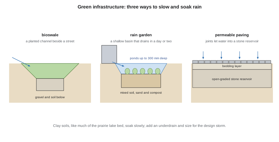
- Rain gardens are shallow planted depressions that collect runoff from roofs, walks and small paved areas and let it soak in over a day or two. They are planted with species that tolerate both wet and dry periods.
- Bioswales are planted channels, usually beside streets and parking lots, that carry, slow and filter runoff. Check dams across the swale hold water back to let it soak in.
- Tree trenches and soil cells under sidewalks direct street runoff into the soil around tree roots, watering the trees and storing water.
- Permeable paving, such as pavers with open joints, porous asphalt or porous concrete, lets water pass through the surface into a stone reservoir beneath, from which it soaks into the ground or drains slowly.
- Green roofs hold rain in their soil and plants and release much of it to the air; extensive green roofs with 75 to 150 mm of growing medium are light and need little care; intensive roofs are deeper gardens.
- Cisterns and rain barrels store roof water for later use in irrigation or toilet flushing.
- Constructed wetlands and stormwater ponds treat and store larger volumes, and can be designed as parks.
Each tool must be designed for the local climate. In a prairie winter, surfaces freeze, snow piles up, and spring melt brings a large pulse of water over frozen ground. Plants must tolerate salt, which is carried in snow plowed off streets. Permeable paving works in cold climates if its stone reservoir is deep enough to drain before freezing and if sand is not used for winter traction, because sand clogs the joints. Inlets must be designed so ice does not block them.
From pipes to parks
Several cities have shown how stormwater can become the organizing idea of public space. After a cloudburst in July 2011 flooded much of Copenhagen, the city adopted a cloudburst plan the following year that combines bigger sewers with streets designed to carry water to parks and plazas that flood temporarily in extreme storms. Rotterdam built water squares, sunken plazas used for sport most of the time that fill with water in heavy rain. Philadelphia's Green City, Clean Waters program, approved in 2011, committed the city to manage much of its combined sewer overflow problem with green infrastructure over twenty-five years.
Flooding on the prairies has also shaped cities at a larger scale. After the great Red River flood of 1950, Manitoba built the Red River Floodway around Winnipeg, completed in 1968 and expanded after the flood of 1997; it has protected the city from many floods since. At the same time, the province has required Winnipeg to reduce overflows from its combined sewers, a long and costly program.
A stormwater park for the greenway district
The students' framework turns the old rail yard south-east of the corner, the lowest land in the district, into a stormwater park. It has three parts. A chain of rain gardens and bioswales along the greenway collects runoff from the streets that slope down to it. A shallow constructed wetland in the centre of the park holds and cleans water from the district's storm sewers after a storm, releasing it slowly. Around the wetland, a sloping meadow and a small forest give the park a dry use in all seasons, with paths, a sliding hill made from the excavated clay and a warming hut. In a rare extreme storm, the meadow itself floods, protecting the underpass and the basements on Aldous Street.
Ingrid works out that the park would occupy about 4 ha of the rail yard. She proposes that the rest of the yard, near the avenue, be developed with housing and workshops whose roofs, lanes and courtyards drain to the park, so the development helps pay for it. Kaminski adds a caution: the wetland must be designed with gentle side slopes and a shallow safety bench at the edge, because children will play there.
A green street on Marlow Street
Marlow Street runs downhill from the avenue to the greenway and carries the bus route and most of the district's runoff towards the underpass. Joon-ho redesigns two blocks of it as a green street. The roadway narrows from 11 m to 7 m, enough for the bus and two lanes of traffic, and the space gained becomes a planted strip on each side. Curb cuts every few metres let street runoff flow into a series of shallow bioswale cells, separated by small check dams, so water steps down the hill from cell to cell instead of racing to the bottom. Between the cells, curb extensions hold bus stops, bike racks and benches. Large trees in soil trenches line the back of the strip, connected underground so their roots share one long body of soil.
Kaminski checks the design against three conditions. In a frequent summer storm, the cells absorb almost all the runoff from the street and sidewalks, and none reaches the underpass. In a rare large storm, the cells fill and overflow back into the gutter, which carries the excess to the stormwater park along a path that does not pass any basements. In winter, the planted strips double as snow storage, the plants are chosen to tolerate salt, and each cell has a high-level overflow inlet that will not freeze shut. She asks Joon-ho to add one more detail: a simple sign at each cell explaining what it does, because residents who understand a rain garden are more likely to help look after it.
Co-benefits and costs
Green infrastructure does more than manage water. It cools streets in summer heat, provides habitat, makes walking more pleasant, raises property values and can create jobs in installation and maintenance. Its costs are real too. It needs space, careful design, construction supervision (compacted soils ruin infiltration) and, above all, ongoing maintenance: removing sediment and litter, weeding, replacing plants killed by salt, clearing inlets. Many programs have failed not in design but in care. Kaminski recommends that every green infrastructure element in the framework plan have a named owner responsible for its upkeep and a budget.
There is also a question of fairness. Flooding, heat and polluted runoff often fall hardest on lower-income neighbourhoods with fewer trees and more pavement, while new green infrastructure and parks can raise land values and rents. Planning green infrastructure with residents, and coupling it with the protections discussed in Lesson 11, helps make sure the people who suffered the floods are the ones who benefit from the park.
Exercise 8: water in the district
- Map the impervious surfaces, drainage directions, low points and flooding problems of your district.
- Estimate the peak runoff from one block with the rational method.
- Size a rain garden or bioswale to capture the first 25 mm of rain from a parking lot.
- Propose a chain of green infrastructure from roofs to streets to a park, and an overland route for extreme storms.
- Write a maintenance plan stating who cares for each element and how often.
Water you can see
Kaminski ends her visit with a principle the students adopt for the whole framework: make water visible. Most of the district's rain disappears into gratings within seconds of falling, and residents never see where it goes until a basement floods. Downspouts that spill into runnels across a plaza, rain chains on the hub's canopy, a small cascade where the bioswale on Marlow Street drops into the stormwater park, and planted cells that fill and empty after each storm all show people how water moves through their district. Visible water teaches, delights children and builds support for paying to maintain the system. It also has to be safe: runnels need to be shallow and crossable by wheelchairs, cascades need to freeze safely, and nothing should create standing water deep enough to be a danger. Joon-ho sketches the hub plaza with a shallow runnel that carries roof water across the paving to a rain garden by the bus stop, frozen into a ribbon of ice in winter and a trickle in spring.
Common mistakes
MistakeTreating green and grey infrastructure as alternatives.
InsteadUse green infrastructure for frequent storms and grey systems and overland routes for extreme ones.
MistakeAssuming water will soak into clay quickly.
InsteadTest soils, add underdrains and design for the time to drain.
MistakeIgnoring winter and spring melt.
InsteadDesign for frozen ground, snow storage, salt and ice at inlets.
MistakeCompacting the ground during construction.
InsteadProtect infiltration areas from machines and test infiltration after construction.
MistakeBuilding without a maintenance plan.
InsteadName the owner, tasks and budget for every element.
Summary and key terms
- Impervious surfaces increase runoff volume, peak flow and pollution.
- Grey infrastructure moves water away; green infrastructure slows, stores, soaks and cleans it where it falls.
- The rational method estimates peak runoff as the runoff coefficient times rainfall intensity times area.
- Rain gardens, bioswales, tree trenches, permeable paving, green roofs, cisterns and wetlands form the toolkit.
- Cold climates require attention to frozen ground, melt, salt, sand and ice.
- Stormwater can shape parks and public spaces, but needs maintenance and fair planning.
- Green infrastructure
- Soils, plants and landform used to manage water close to where it falls.
- Runoff coefficient
- The share of rainfall that runs off a surface, from near 0.1 for woodland to about 0.95 for roofs.
- Combined sewer
- A sewer that carries both sewage and storm water in one pipe.
- Combined sewer overflow
- The discharge of mixed sewage and storm water into a river when combined sewers are overloaded.
- Rain garden
- A shallow planted basin that collects runoff and lets it soak in.
- Bioswale
- A planted channel that carries, slows and filters runoff.
Practice problems
Work each problem on paper first, then reveal the answer to check.
A parking lot of 2,000 m² has a runoff coefficient of 0.9. How much water runs off in a 25 mm storm?
Show answer
About 45 m³.
How large a rain garden with 300 mm of ponding would hold that volume?
Show answer
About 150 m², or 7.5% of the lot.
Why must permeable paving in cold climates avoid sand for traction?
Show answer
Sand clogs the open joints and stone reservoir, stopping infiltration.
What does a combined sewer overflow carry into rivers?
Show answer
A mixture of storm water and raw sewage.
Name two co-benefits of green infrastructure beyond water management.
Show answer
Summer cooling, habitat, more pleasant streets, higher property values, local jobs.
Lesson quiz · 5 questions
Score 60% or more to complete this lesson.
Create a free account to save your progress, take quizzes and earn a certificate.