
ARCH-340 · Lesson 2 of 12 · 19 min
History of city planning
Desrosiers begins the second class with a question: why are the streets of the greenway district laid out the way they are? Callum guesses that someone drew a grid because grids are easy. Ingrid points out that the grid is broken by the rail line and that the streets north of the avenue are skewed a few degrees from those to the south. Joon-ho has found an old map in the library showing long, narrow river lots running back from the river, the pattern of the Red River Settlement, under the later survey grid. 'Every street you walked on Monday,' Desrosiers says, 'is the result of a decision someone made, usually for reasons that had nothing to do with you. This lesson is about those decisions and the ideas behind them. You cannot repair a district without knowing why it is the way it is.'
The history of city planning is long and global, and this lesson can only sketch it. The aim is to recognize the main ideas that still shape cities, to see them in the students' own district and to understand their strengths and their costs.
The grid
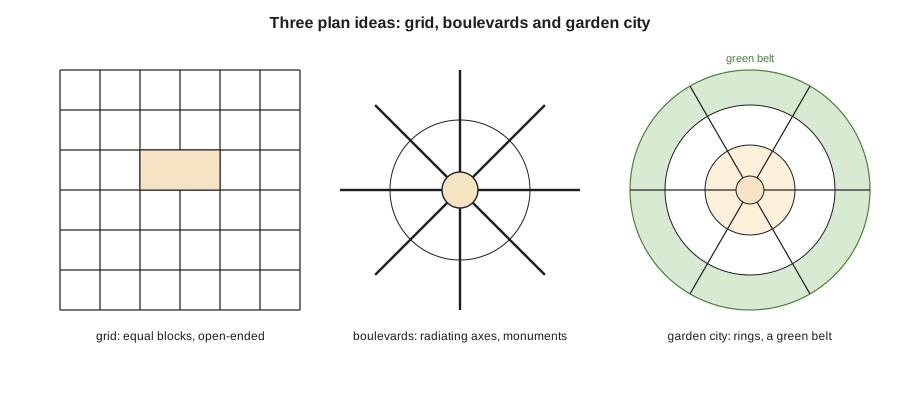
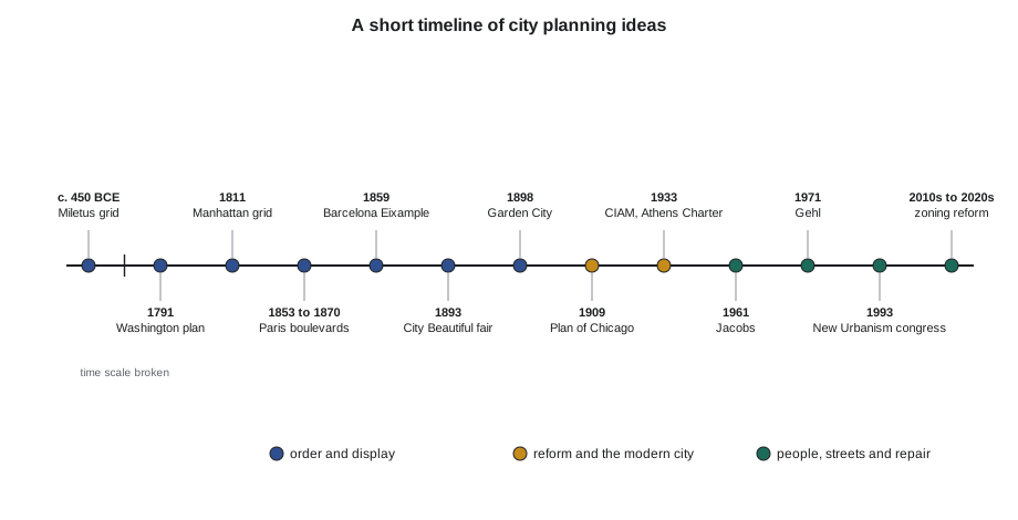
The grid is the oldest planned city form and still the most common. Grids appear in the Indus valley cities around 2500 BCE, in Chinese capitals, in Greek colonies and in Roman military camps. The Greek planner Hippodamus is traditionally credited with the orderly grid of Miletus, rebuilt in the fifth century BCE after its destruction by the Persians, though grids had existed long before him. The Spanish Laws of the Indies of 1573 prescribed grids around a central plaza for new towns across the Americas.
In North America the grid became a tool of land distribution. In Canada, the Dominion Lands Survey from 1871 divided the prairies into townships of square-mile sections, and prairie cities including Winnipeg grew as street grids laid over that survey, interrupted by rail lines and by the older river lots that the Métis and earlier settlers had laid out at right angles to the Red and Assiniboine rivers. The Commissioners' Plan of 1811 laid a grid over almost all of Manhattan, with long blocks between avenues, regardless of hills and streams.
The grid's strengths are simplicity, flexibility and connectivity. Lots are easy to survey and sell; any use can occupy any block; there are many routes between any two points; and the city can grow in any direction. Its weaknesses are monotony, indifference to topography and a lack of hierarchy: on a pure grid no street is more important than any other, and nothing marks a centre. Many of the best grid cities add exceptions such as diagonal avenues, parks, squares and civic buildings that terminate views.
The students compare the dimensions of some famous grids, and their own, by computing how many intersections each creates in a square kilometre and how much of the land goes to streets.
# Historic block patterns: size, perimeter and intersections per square km
patterns = [  # name, block length, block width (m), street width (m)
    ("Miletus-style grid", 52, 30, 6),
    ("Manhattan 1811 grid", 240, 60, 18),
    ("Barcelona Eixample", 113, 113, 20),
    ("Portland downtown", 61, 61, 18),
    ("prairie city lot grid", 200, 90, 20),
]
for name, a, b, st in patterns:
    cell = (a + st) * (b + st)                 # one block plus half of each street around it
    per_ku = 1000000.0 / cell                     # blocks per square km
    inter = per_ku                              # one intersection per block in a regular grid
    street_share = 1 - (a * b) / cell
    print(f"{name:<22} {a:>5.0f} x {b:<5.0f} perimeter {2 * (a + b):>6,.0f} m  "
f"{inter:>4.0f} intersections per sq km streets {street_share:.0%} of land")Miletus-style grid 52 x 30 perimeter 164 m 479 intersections per sq km streets 25% of land Manhattan 1811 grid 240 x 60 perimeter 600 m 50 intersections per sq km streets 28% of land Barcelona Eixample 113 x 113 perimeter 452 m 57 intersections per sq km streets 28% of land Portland downtown 61 x 61 perimeter 244 m 160 intersections per sq km streets 40% of land prairie city lot grid 200 x 90 perimeter 580 m 41 intersections per sq km streets 26% of land
The numbers show what the students feel on foot. Small blocks, such as Portland's square 61 m blocks, create many intersections and many corners but give more land to streets. The long Manhattan blocks and the long prairie blocks create few intersections in one direction; walking across them is tedious. Barcelona's blocks, at about 113 m square with chamfered corners, are a middle path. In Lesson 3 the students will study block size in detail.
Order and display: boulevards and the City Beautiful
A second tradition uses streets to organize a city around monuments and axes. Pierre L'Enfant's plan for Washington of 1791 laid broad diagonal avenues over a grid, linking the Capitol, the President's House and other sites. Between 1853 and 1870, Baron Haussmann, working for Napoleon III, cut wide boulevards through the dense medieval fabric of Paris, adding sewers, water supply, parks and uniform apartment buildings along the new streets. The boulevards made traffic, light and air possible and created one of the most admired urban landscapes in the world; they also displaced tens of thousands of poor residents and made the city easier to control by force.
In 1859 Ildefons Cerdà's plan for the extension of Barcelona, the Eixample, took a different approach: a uniform grid of blocks with chamfered corners, designed to give every home light and air and to spread services evenly. In North America the World's Columbian Exposition in Chicago in 1893, with its white classical buildings around a formal basin, launched the City Beautiful movement, which believed that civic beauty would encourage civic virtue. Daniel Burnham and Edward Bennett's Plan of Chicago of 1909 proposed diagonal boulevards, a civic centre and a public lakefront. Many North American cities built civic centres, boulevards and parkways in this spirit. Winnipeg's Broadway and the Manitoba Legislative Building of 1920, set at the end of a formal mall, are local examples.
Reform: garden cities and the modern movement
The industrial city of the nineteenth century was crowded, polluted and unhealthy. Reformers responded in two very different ways.
Ebenezer Howard's book of 1898, republished in 1902 as Garden Cities of To-morrow, proposed new towns of about 32,000 people on land owned in common, surrounded by a permanent belt of farmland, with homes, factories, parks and civic buildings arranged in rings. Letchworth (1903) and Welwyn (1920) in England were built on his principles. The garden city idea spread worldwide, though usually as garden suburbs without the shared land ownership that Howard thought essential. In North America, Radburn in New Jersey (1929) separated pedestrians from cars by placing houses around cul-de-sacs facing shared parkland, with underpasses where paths crossed roads. Wildwood Park in Winnipeg, begun in 1946, applied the Radburn idea: its houses face shared green spaces, with cars kept to the back.
The modern movement took the opposite approach. Le Corbusier's proposals of the 1920s, such as the Plan Voisin for Paris, imagined towers in parkland linked by highways. The International Congresses of Modern Architecture (CIAM) set out principles in the Athens Charter, written at the 1933 congress and published in 1943: separate the four functions of dwelling, work, recreation and circulation; replace the street with highways and paths; and set tall buildings far apart for sun and air. After 1945 these ideas shaped public housing, urban renewal and new towns across the world. In Canada, the federal government funded slum clearance and public housing projects such as Regent Park in Toronto.
The costs of renewal and the highway era
Urban renewal cleared large areas of older housing, often occupied by poor, immigrant and racialized communities, and replaced them with public housing towers, civic projects, parking and highways. Some residents gained better homes; many lost homes, businesses, churches and networks of neighbours that could not be rebuilt. In Canada, Africville in Halifax was demolished between 1964 and 1970, and Vancouver's Hogan's Alley, the heart of its Black community, was largely destroyed for the Georgia Viaduct around 1970. In Winnipeg, the Métis and mixed community known as Rooster Town, on the city's south-west edge, was cleared around 1960 as suburban development reached it. Lesson 11 returns to these stories and what designers can do about their legacy.
Opposition grew through the 1950s and 1960s. In New York, community groups including Jane Jacobs fought Robert Moses's plans for an expressway through Lower Manhattan and won. In Toronto, opposition stopped the Spadina Expressway in 1971.
People and streets: Jacobs, Lynch, Whyte and Gehl
In 1960 Kevin Lynch's The Image of the City asked residents of Boston, Jersey City and Los Angeles to draw maps of their cities from memory. He found that people organize their mental maps using five elements: paths, edges, districts, nodes and landmarks. A city whose elements are clear is legible, and legibility helps people feel at home.
In 1961 Jane Jacobs's The Death and Life of Great American Cities attacked the assumptions of modernist planning. She argued that lively, safe city districts need a mix of primary uses that bring people out at different times of day, short blocks, buildings of different ages and a dense concentration of people. She coined the phrase 'eyes on the street' for the informal surveillance of people in shops and windows that makes a sidewalk safe. Her work inspired generations of planners and citizens, though critics note that she underestimated the role of affordable housing policy in keeping a district diverse.
In the 1970s William Whyte filmed and counted people in New York's plazas and found that the most used plazas had places to sit, sun, water, trees, food and a close connection to the street; his findings shaped New York's plaza rules in 1975. In Copenhagen Jan Gehl studied how people use streets and squares and published Life Between Buildings in 1971. Gehl's methods of counting and observing public life are now used in cities around the world, and Lesson 4 applies them.
New Urbanism, smart growth and repair
From the 1980s architects and planners began to design new neighbourhoods on traditional principles: connected streets, mixed uses, varied housing, a defined centre and edge, and civic buildings in prominent places. Seaside in Florida (begun 1981) and Kentlands in Maryland were early examples, and the Congress for the New Urbanism was founded in 1993. In parallel, the smart growth movement promoted compact development near transit, and transit-oriented development became a widely used planning goal, explored in Lesson 6.
Since about 2000 the emphasis has shifted again, from building new districts to repairing existing ones: retrofitting suburbs, reconnecting neighbourhoods divided by highways, redesigning streets for walking and cycling, planting trees, managing rain where it falls and allowing more homes in areas once zoned only for detached houses. Winnipeg's reopening of Portage and Main to pedestrians on 27 June 2025, after the intersection had been closed to foot traffic since 1979, is a recent symbol of this shift. The greenway district is a repair project of exactly this kind.
Reading history in the district
Desrosiers asks the students to read their own district as a historical document. Callum finds that the houses north of the avenue were built between 1905 and 1925 on 7.6 m lots for workers at the rail yards, which explains their narrow fronts and back lanes. Wren discovers that the greenway follows a branch line built in the 1880s and abandoned in the 1990s; its curving path explains why the streets south of it are cut off from those to the north. Ingrid finds that the lumber yard took over a block of houses in the 1950s, closing two streets. Joon-ho finds the 1960s plan for the area, which proposed clearing the shops on the avenue for a four-lane arterial with parking lots; only half was built, which is why the avenue is wide but the shop fronts survive on its north side.
Each finding suggests a design move. The closed streets could be reopened. The greenway's crossings could become the district's main connections. The surviving shop fronts could anchor the main street. 'History,' says Desrosiers, 'is the brief your site gives you before your client does.'
Exercise 2: history of a district
- Find the oldest map, survey or aerial photograph you can of your district. Trace its streets, rail lines and water over a current map.
- Date the main periods of building in the district and mark them on a figure-ground.
- Identify one decision from each of the grid, City Beautiful, garden city, modern and repair traditions that is visible in your district, or explain why none is.
- Find out who lived in the district a century ago and who lives there now. Identify any episodes of clearance or displacement.
- List three design moves suggested by the district's history.
Common mistakes
MistakeTreating historical plans as styles to imitate.
InsteadUnderstand the problem each idea tried to solve and what it cost, then decide what is useful now.
MistakeAssuming the existing street pattern is natural or inevitable.
InsteadFind the decisions, surveys and owners that produced it.
MistakeForgetting who was displaced by past plans.
InsteadLearn the district's full history, including the communities that were cleared or divided.
MistakeTreating Jacobs or Gehl as rules to apply everywhere.
InsteadUse their observations as methods for studying a particular place.
MistakeCalling every grid the same.
InsteadCompare block sizes, street widths and exceptions; a fine grid and a coarse grid behave very differently.
Summary and key terms
- The grid is the oldest and most common planned form; in North America it grew from land survey systems and is flexible but lacks hierarchy.
- Boulevards and the City Beautiful organized cities around axes and monuments, at great cost to people displaced.
- Garden cities and the modern movement were opposite responses to the unhealthy industrial city; the second shaped renewal and highways after 1945.
- Urban renewal and highways destroyed many communities, often poor and racialized, and provoked freeway revolts.
- Lynch, Jacobs, Whyte and Gehl shifted attention to how people perceive and use streets and public spaces.
- New Urbanism, smart growth and transit-oriented development led to today's emphasis on repairing existing districts.
- Grid
- A street pattern of straight streets crossing at right angles, forming regular blocks.
- City Beautiful
- A movement of the 1890s to 1910s that used classical civic buildings, boulevards and parks to improve cities.
- Garden city
- Ebenezer Howard's model of a planned town of limited size on shared land, surrounded by a green belt.
- Athens Charter
- The CIAM statement that called for separating dwelling, work, recreation and circulation.
- Urban renewal
- The postwar clearance and redevelopment of older urban areas, often with public housing, highways and civic projects.
- Eyes on the street
- Jacobs's phrase for the informal watchfulness of people in buildings and shops that makes streets safer.
Practice problems
Work each problem on paper first, then reveal the answer to check.
Which grid in the code output creates the most intersections per unit area, and why?
Show answer
The Miletus-style grid, because its blocks are the smallest; every block adds roughly one intersection.
Name one strength and one weakness of a uniform grid.
Show answer
Strength: connectivity and flexibility. Weakness: monotony and lack of hierarchy or centre.
What did the Athens Charter propose?
Show answer
Separating dwelling, work, recreation and circulation, with tall buildings far apart and highways replacing streets.
What are Lynch's five elements of the city image?
Show answer
Paths, edges, districts, nodes and landmarks.
Give an example of urban repair from your country.
Show answer
Reopening Portage and Main to pedestrians in 2025 (other examples are acceptable).
Lesson quiz · 5 questions
Score 60% or more to complete this lesson.
Create a free account to save your progress, take quizzes and earn a certificate.