
GEOM-300 · Lesson 12 of 12 · 25 min
Integrity, jamming and spoofing
On a Tuesday in October, every RTK rover on the canal job lost its fix at the same moment. The base receiver near the highway showed C/N0 values ten to fifteen decibels below normal on every satellite, and the rovers within a kilometer of the highway could not track at all. Twenty minutes later everything returned to normal. Ruth Albrecht recognized the signature: a vehicle on the highway carrying a GNSS jammer, illegal but cheap, probably fitted by a driver who did not want a fleet tracker to report his position. The incident prompted the last topic of the course. GNSS signals are weak and openly specified, so they can be drowned out or imitated, and a surveyor, engineer or system designer must know how to tell when positions cannot be trusted and what to do about it.
What integrity means
Four measures describe the performance of a navigation system. Accuracy is how close positions are to the truth, usually stated at 95 %. Integrity is the ability of the system to warn users within a specified time when it should not be used. Continuity is the probability that the service, once started, continues without interruption through an operation such as an aircraft approach. Availability is the fraction of time that the service meets all the other requirements. For aviation, integrity is expressed with three quantities: the alert limit, the largest error that can be tolerated for an operation; the time to alert; and the integrity risk, the probability that the error exceeds the alert limit without an alert, typically of order \(10^{-7}\) per approach. The receiver or augmentation system computes a protection level, a bound on the position error that holds with that probability; if the protection level exceeds the alert limit, the operation is not available.
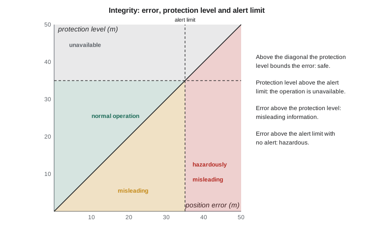
Surveyors rarely compute protection levels, but the same idea runs through survey quality control. Redundant observations, independent checks, statistical tests on residuals and repeat measurements are how a survey protects its users against a measurement that is wrong without looking wrong. The methods of this lesson apply equally to a pseudorange solution, an RTK fix and a network adjustment.
Receiver autonomous integrity monitoring
RAIM checks the consistency of the measurements within a single receiver. With more satellites than unknowns, the least-squares solution has residuals, and if all measurements are good, the weighted sum of squared residuals follows a chi-square distribution with \(n - 4\) degrees of freedom for a single-system solution. A fault in one pseudorange inflates the sum. The detection test compares
where \(P_{fa}\) is the chosen false-alarm probability. With five satellites a fault can be detected but not identified; with six or more it can usually be excluded by repeating the test on each subset with one satellite removed, a process called fault detection and exclusion (FDE). A least-squares solution spreads a fault over all residuals, so the largest residual does not always belong to the faulty satellite; testing the subsets is more reliable. Advanced RAIM (ARAIM), now being developed for aviation, extends the idea to multiple constellations and to the possibility of faults affecting a whole constellation at once.
The program below takes the eight-satellite geometry of Lesson 4, adds a 25 m fault to the fourth pseudorange, and runs detection and exclusion. It then shows a simple interference check based on the C/N0 of all tracked satellites.
# Receiver autonomous integrity monitoring (RAIM): detect and exclude a faulty range, and watch C/N0
import math, random
random.seed(7)

def ecef(lat, lon, h, a=6378137.0, f=1 / 298.257222101):
    e2 = f * (2 - f); la, lo = math.radians(lat), math.radians(lon)
    N = a / math.sqrt(1 - e2 * math.sin(la) ** 2)
    return [(N + h) * math.cos(la) * math.cos(lo), (N + h) * math.cos(la) * math.sin(lo), (N * (1 - e2) + h) * math.sin(la)]

def enu_rows(lat, lon):
    la, lo = math.radians(lat), math.radians(lon)
    return [[-math.sin(lo), math.cos(lo), 0.0],
            [-math.sin(la) * math.cos(lo), -math.sin(la) * math.sin(lo), math.cos(la)],
            [math.cos(la) * math.cos(lo), math.cos(la) * math.sin(lo), math.sin(la)]]

LAT, LON, H = 47.5060042, -111.2977909, 1004.826         # pillar CR1
truth = ecef(LAT, LON, H); R = enu_rows(LAT, LON)
c = 299792458.0; clock = 1.25e-4                         # receiver clock 125 microseconds fast

# Satellites placed at the given azimuth and elevation on a 26 560 km orbit sphere
sky = [(15, 72), (68, 34), (122, 18), (171, 49), (215, 26), (262, 61), (301, 14), (340, 38)]
sats = []
for az, el in sky:
    a, e = math.radians(az), math.radians(el)
    u_enu = [math.cos(e) * math.sin(a), math.cos(e) * math.cos(a), math.sin(e)]
    u = [sum(R[k][i] * u_enu[k] for k in range(3)) for i in range(3)]       # ENU to ECEF
    b = sum(ui * ti for ui, ti in zip(u, truth)); r2 = sum(t * t for t in truth)
    rho = -b + math.sqrt(b * b - r2 + 26560e3 ** 2)
    sats.append([t + rho * ui for t, ui in zip(truth, u)])
SIGMA = 1.5
P = [math.dist(s, truth) + c * clock + random.gauss(0, SIGMA) for s in sats]
P[3] += 25.0                                             # a 25 m fault on the fourth satellite

def solve(A, y):   # normal equations by Gaussian elimination
    n = len(A[0]); N = [[sum(A[k][i] * A[k][j] for k in range(len(A))) for j in range(n)] for i in range(n)]
    u = [sum(A[k][i] * y[k] for k in range(len(A))) for i in range(n)]
    M = [N[i] + [u[i]] + [1.0 if i == j else 0.0 for j in range(n)] for i in range(n)]
    for col in range(n):
        p = max(range(col, n), key=lambda r: abs(M[r][col])); M[col], M[p] = M[p], M[col]
        d = M[col][col]; M[col] = [v / d for v in M[col]]
        for r in range(n):
            if r != col:
                f = M[r][col]; M[r] = [a - f * b for a, b in zip(M[r], M[col])]
    return [M[i][n] for i in range(n)], [row[n + 1:] for row in M]

def lsq(idx):
    x = [0.0, 0.0, 0.0, 0.0]
    for _ in range(10):
        A, w = [], []
        for i in idx:
            rho = math.dist(sats[i], x[:3])
            A.append([(x[k] - sats[i][k]) / rho for k in range(3)] + [1.0]); w.append(P[i] - (rho + x[3]))
        dx, Q = solve(A, w); x = [a + b for a, b in zip(x, dx)]
    res = [P[i] - (math.dist(sats[i], x[:3]) + x[3]) for i in idx]
    d = [a - b for a, b in zip(x[:3], truth)]
    err_h = math.hypot(sum(R[0][i] * d[i] for i in range(3)), sum(R[1][i] * d[i] for i in range(3)))
    err_v = sum(R[2][i] * d[i] for i in range(3))
    return sum((r / SIGMA) ** 2 for r in res), res, err_h, err_v

THRESH = {4: 18.47, 3: 16.27}            # chi-square thresholds for a false-alarm probability of 0.001
allsat = list(range(len(sats)))
T_all, res, eh, ev = lsq(allsat)
print("all", len(allsat), "satellites: test statistic", round(T_all, 1), "threshold", THRESH[len(allsat) - 4],
      "-> fault detected" if T_all > THRESH[len(allsat) - 4] else "-> consistent")
print("  residuals (m):", ", ".join(format(r, "+.1f") for r in res), "  horizontal error", round(eh, 2), "m, vertical", round(ev, 2), "m")
for drop in allsat:                      # exclusion: try every subset with one satellite removed
    sub = [i for i in allsat if i != drop]
    Ts, _, eh, ev = lsq(sub)
    flag = "consistent" if Ts < THRESH[len(sub) - 4] else "fault remains"
    print("  without satellite", drop + 1, ": statistic", format(Ts, "5.1f"), flag.ljust(13), "errors H", format(eh, "5.2f"), "V", format(ev, "6.2f"), "m")

# Interference monitoring: C/N0 of all tracked satellites drops together when a jammer is near
normal = [46, 44, 39, 45, 41, 47, 37, 43]
now = [33, 31, 27, 32, 29, 34, 25, 30]
drops = [a - b for a, b in zip(normal, now)]
print("C/N0 drop per satellite (dB):", drops)
if min(drops) > 6:
print("every satellite dropped by more than 6 dB at once: treat as interference, log time and place, rely on inertial or other sources")all 8 satellites: test statistic 186.8 threshold 18.47 -> fault detected residuals (m): -4.7, -0.3, -4.3, +16.1, -7.6, -6.1, +4.7, +1.9 horizontal error 6.1 m, vertical -8.38 m without satellite 1 : statistic 169.6 fault remains errors H 5.07 V -14.63 m without satellite 2 : statistic 186.8 fault remains errors H 5.99 V -8.31 m without satellite 3 : statistic 164.6 fault remains errors H 8.72 V -1.25 m without satellite 4 : statistic 0.3 consistent errors H 1.71 V 1.89 m without satellite 5 : statistic 130.5 fault remains errors H 12.87 V -3.91 m without satellite 6 : statistic 159.9 fault remains errors H 7.13 V -14.65 m without satellite 7 : statistic 151.2 fault remains errors H 10.73 V -21.54 m without satellite 8 : statistic 184.1 fault remains errors H 7.16 V -8.38 m C/N0 drop per satellite (dB): [13, 13, 12, 13, 12, 13, 12, 13] every satellite dropped by more than 6 dB at once: treat as interference, log time and place, rely on inertial or other sources
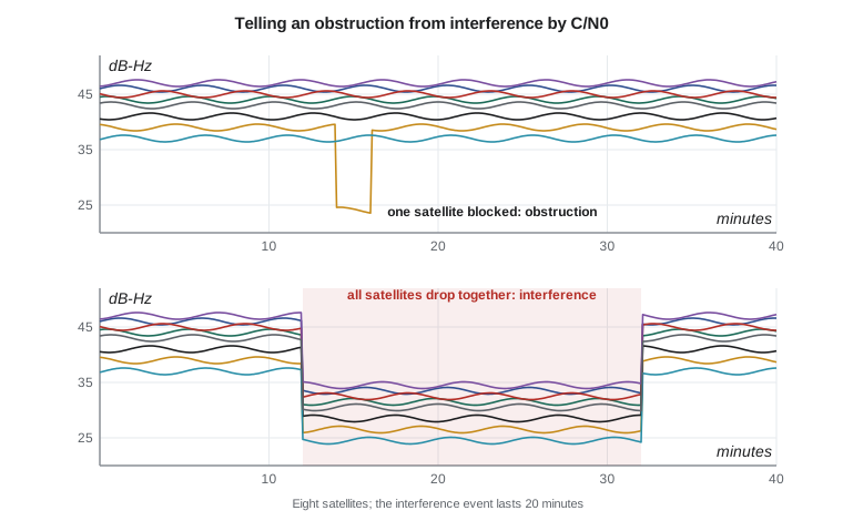
With all eight satellites the test statistic is 186.8, far above the threshold of 18.47 for four degrees of freedom and a false-alarm probability of 0.001, so a fault is detected; the faulty solution is 6.1 m off horizontally and 8.4 m vertically. Removing each satellite in turn, only the subset without satellite 4 passes the test, with a statistic of 0.3, and its errors return to the 2 m level expected from the noise. The fault is identified and excluded. In the second part every satellite's C/N0 has dropped by 12 to 13 dB at the same moment. A single obstruction affects only the satellites behind it; a simultaneous drop on all satellites, in all directions, is the signature of interference.
Worked problem
A RAIM test by hand
The eight residuals of the faulty solution are −4.7, −0.3, −4.3, +16.1, −7.6, −6.1, +4.7 and +1.9 m, and each pseudorange has σ = 1.5 m. Compute the test statistic and decide whether a fault is present at a false-alarm probability of 0.001.
Show solution
- \[\textstyle\sum v_i^2 = 22.09 + 0.09 + 18.49 + 259.21 + 57.76 + 37.21 + 22.09 + 3.61 = 420.55\ \text{m}^2\]
- \[T = \frac{420.55}{1.5^2} = 186.9\]
- \[n - 4 = 4 \text{ degrees of freedom}, \quad \chi^2_{0.999}(4) = 18.47\]
- \[T = 186.9 > 18.47 \;\Rightarrow\; \text{fault detected}\]
Answer: The statistic exceeds the threshold by a factor of ten, so the measurements are inconsistent and the solution should not be trusted until the fault is excluded. If the residuals had been consistent with 1.5 m noise, T would have been around 4, the number of degrees of freedom.
Interference and jamming
GNSS signals arrive at the antenna about 20 dB below the thermal noise, so it takes very little power to overwhelm them. Unintentional interference comes from harmonics of other transmitters, faulty amplifiers in television antennas, some lighting and electronic equipment, and occasionally from solar radio bursts, which raise the noise across the whole sunlit hemisphere for minutes. Intentional jamming is the deliberate transmission of noise or tones in the GNSS bands. Small jammers plugged into a vehicle's power socket, sold as privacy devices, can disrupt receivers for hundreds of meters to kilometers around a highway, as on the canal job. Military jamming in conflict zones has disrupted GNSS for civil aviation and shipping over wide areas in recent years.
In the United States, the Federal Communications Commission prohibits the marketing, sale and use of jamming equipment by the public, and it can impose substantial fines. Interference can be reported to the FCC and, for GPS, to the U.S. Coast Guard Navigation Center, which collects reports of GPS problems from civil users. Surveyors who experience interference should record the time, place, affected signals and receiver data with their report.
The effects of interference build up as its power rises: C/N0 falls on all satellites, carrier tracking becomes noisy and slips cycles, RTK fixes are lost, then carrier tracking fails while code tracking continues for a while, and finally the receiver loses all signals. Receivers monitor the automatic gain control of their front end, which reduces gain when broadband power rises, and C/N0 across satellites; together these are simple and effective detectors. Spectrum displays in some receivers show the shape and frequency of the interference. Mitigation measures include placing antennas to shield them from the horizon where interference sources such as roads lie, using receivers with notch and pulse-blanking filters, tracking several frequency bands so that narrowband interference in one leaves the others usable, using inertial and other sensors to bridge disruptions, and, for critical installations, controlled reception pattern antennas, arrays that steer nulls toward interference sources.
Spoofing
Spoofing is the transmission of counterfeit GNSS signals intended to make a receiver compute a false position or time. Because the open signals are fully documented and carry no authentication, a sufficiently capable transmitter can, in principle, imitate them. A simpler variant, meaconing, rebroadcasts real signals received elsewhere, with a delay. A successful spoof can be more dangerous than jamming, because the receiver continues to report a position and a good-looking accuracy, while the position or the time slowly diverges from the truth. Spoofing has been reported affecting ships and aircraft in several regions; for civil infrastructure, the most worrying targets are the timing receivers that synchronize telecommunications networks, power grids and financial systems, which often take their time from GNSS alone.
This lesson is concerned with recognizing and resisting spoofing, not with how it is done. The defenses rely on the fact that counterfeit signals are hard to make consistent with every independent check a receiver can apply. Defenses fall into four groups:
| Defense | What it checks | Notes |
|---|---|---|
| Signal-level monitoring | Unusually uniform or high power across satellites, sudden C/N0 changes, distorted correlation peaks, AGC changes | Inexpensive and available in many receivers |
| Consistency checks | RAIM residuals, agreement between constellations and frequencies, receiver clock jumps, implausible velocity or position jumps | A spoofer imitating every system and frequency consistently is much harder to build |
| Independent sensors | Agreement with an IMU, odometry, a stable local clock, terrestrial positioning or a total station | Catches slow drift that signal checks miss |
| Authentication and antenna techniques | Cryptographic signatures on navigation data, such as Galileo OSNMA; angle of arrival measured by antenna arrays | All real signals arrive from different directions; a single spoofing transmitter does not |
Galileo's OSNMA, operational since July 2025, lets receivers verify that the navigation data come from Galileo. Authentication of the data does not by itself prove that the ranging signal is genuine, since a meaconer can rebroadcast authentic data with a delay, but it raises the bar considerably and works together with consistency and timing checks. Navigation message authentication for other systems is being studied and developed, and future signals may add encrypted spreading codes for authorized users. For timing users, guidance from national agencies on resilient positioning, navigation and timing encourages holdover clocks, multiple independent time sources and monitoring rather than reliance on a single GNSS receiver.
Defensive practice for surveyors and engineers
Most survey work will never meet deliberate spoofing, but the same habits defend against interference, faults and blunders. Know what normal looks like at a site: record typical C/N0, satellite counts and fix times, so that an abnormal day stands out. Keep raw observation data rather than only positions, so that a suspicious result can be reprocessed and tested. Use multiple constellations and frequencies. Check every session against independent control and repeat critical observations at different times. In machine control and monitoring systems that run unattended, set alarms on C/N0 and AGC, on the number of tracked satellites and on jumps in position or receiver clock, and design the system to degrade safely, stopping a machine or flagging data rather than continuing on bad positions. For permanent monitoring stations and timing installations, place antennas with a clear view of the sky but shielded from roads, use interference-resistant antennas where justified, and keep a stable local clock to detect time jumps.
On the canal job, the base log showed that the October event lasted 21 minutes and coincided with a large drop in AGC. Ruth filed a report with the time and location and the receiver data, the crew re-observed the stakes set during that window, and the firm moved its base for highway-side work a few hundred meters back from the road, behind a berm. None of that required special equipment: only knowing the signatures, keeping the data and checking the work.
Course summary
This course followed the chain from satellites to coordinates. The constellations and their signals provide pseudoranges and carrier phases. Orbits and clocks place the satellites; least squares and DOP turn ranges into positions; error sources limit what one receiver can do alone. Differential methods remove common errors; carrier-phase ambiguity resolution unlocks millimeter precision in static, RTK and PPP positioning; networks and services connect every result to the national frame at a stated epoch; inertial integration fills the gaps; and integrity monitoring tells the user when not to trust the result. GEOM-310 and later courses build on these foundations for photogrammetry, lidar, hydrography and engineering surveys.
Common mistakes
MistakeTreating a reported accuracy as integrity.
InsteadAccuracy estimates assume good data; integrity requires tests that detect when data are bad.
MistakeBlaming an obstruction for a simultaneous drop on all satellites.
InsteadA drop in every direction at once indicates interference; record it and check the AGC.
MistakeAssuming the largest residual marks the faulty satellite.
InsteadLeast squares spreads a fault; test subsets for exclusion.
MistakeRelying on a single GNSS receiver for critical timing.
InsteadUse holdover clocks, multiple sources and monitoring.
MistakeDiscarding raw data after a survey.
InsteadRaw observations allow suspicious results to be reprocessed and tested later.
Summary and key terms
- Integrity is the ability to warn users in time when positions should not be used; protection levels bound errors against alert limits.
- RAIM tests the sum of squared residuals against a chi-square threshold; with six or more satellites faults can be excluded.
- GNSS signals are weak; jammers overwhelm them, and their use is prohibited in Canada and the United States.
- Interference shows as a simultaneous drop in C/N0 on all satellites and changes in AGC.
- Spoofing imitates signals; defenses combine signal monitoring, consistency checks, independent sensors and authentication.
- Galileo OSNMA authenticates navigation data; it complements, but does not replace, other checks.
- Good practice: know normal conditions, keep raw data, use multiple systems, check independently and design systems to fail safely.
- Integrity
- The ability of a navigation system to warn users within a specified time when it should not be used.
- Protection level
- A statistical bound on the position error computed by the receiver or augmentation system.
- RAIM
- Receiver autonomous integrity monitoring: consistency checks on redundant measurements within a receiver.
- Jamming
- Interference that prevents GNSS reception by overwhelming the signals with noise or tones.
- Spoofing
- Transmission of counterfeit GNSS signals intended to produce a false position or time.
- OSNMA
- Open Service Navigation Message Authentication: cryptographic authentication of Galileo navigation data.
Practice problems
Work each problem on paper first, then reveal the answer to check.
How many degrees of freedom does a RAIM test have with 9 satellites from one system?
Show answer
9 − 4 = 5.
Why can a fault be detected but not excluded with five satellites?
Show answer
With one degree of freedom, removing any one satellite leaves a solution with no redundancy to test.
C/N0 falls on three satellites in the west only. What is the likely cause?
Show answer
An obstruction or reflector to the west, not interference.
Name two independent checks that would reveal a slowly drifting spoofed position.
Show answer
An IMU or odometry, and a check shot on known control or a total station.
What does OSNMA authenticate?
Show answer
The Galileo navigation message data on E1, not the ranging signal itself.
Lesson quiz · 5 questions
Score 60% or more to complete this lesson.
Create a free account to save your progress, take quizzes and earn a certificate.