
AERO-350 · Lesson 10 of 12 · 25 min
Communication and surveillance
Air traffic control keeps aircraft apart by knowing where they are and by talking to them. Communication systems carry voice and data between crews and controllers, between aircraft and their operators, and between aircraft themselves. Surveillance systems tell controllers, and increasingly other aircraft, where each aircraft is. For most of aviation's history surveillance meant radar; today it increasingly means aircraft broadcasting their own satellite-derived position. This lesson describes the radios, transponders and broadcast systems that a modern aircraft carries, the rules that require them in Canada and the United States, and what they mean for the Tern Block 2 flying in remote airspace.
Voice and data communication
Very high frequency radio, in the band 118 to 137 MHz, carries most air traffic control voice. It is line-of-sight: the program shows that an aircraft at 10 000 ft can reach a ground antenna about 130 NM away, and one at 41 000 ft about 260 NM, but behind mountains or below the horizon there is nothing. Channels are spaced 25 kHz apart in North America; Europe uses 8.33 kHz spacing in much of its airspace to fit more channels into the band. High frequency radio, between 2.8 and 22 MHz, bounces off the ionosphere and carries voice over oceans and remote areas, but it is noisy and depends on time of day and solar activity. Satellite communication, through geostationary or low Earth orbit constellations, gives voice and data almost anywhere.
Data link is replacing much routine voice. Controller-pilot data link communications, CPDLC, lets controllers send clearances such as level changes and frequency transfers as text messages that the crew accepts with a button, cutting radio congestion and misheard instructions. It is widely used over oceans and in busy airspace. The aircraft communications addressing and reporting system, ACARS, carries operational messages between aircraft and their operator, such as departure and arrival times, engine reports and weather. For the Tern, flying long legs over rural Alaska and the northern plains where VHF coverage is patchy, a satellite data link is the only reliable way to stay in touch with dispatch, and the systems team has included one in the Block 2 baseline.
Transponders and secondary radar
Primary radar detects aircraft by their reflection and needs no cooperation, but gives no identity or altitude and has trouble with small aircraft. Secondary surveillance radar interrogates aircraft transponders on 1030 MHz, and they reply on 1090 MHz. A Mode A reply gives the four-digit code the controller assigned, a Mode C reply adds pressure altitude, and Mode S, the current standard, gives each aircraft a unique 24-bit address so that the radar can interrogate aircraft selectively and exchange more data. Special codes signal emergencies, radio failure and unlawful interference; crews are trained to select them only when needed.
Airborne collision avoidance builds on transponders. TCAS II, the common implementation of the airborne collision avoidance system, interrogates nearby transponders, tracks their range, bearing and altitude, and issues traffic advisories and then resolution advisories, vertical commands such as climb or descend, when another aircraft threatens to come too close. When both aircraft have TCAS II, their systems coordinate so that their maneuvers complement each other. Crews must follow a resolution advisory promptly even if it conflicts with a controller's instruction, a lesson from a mid-air collision in 2002. Collision avoidance equipment is required on larger aircraft by the rules of both countries; smaller aircraft such as the Tern often carry simpler traffic systems.
ADS-B
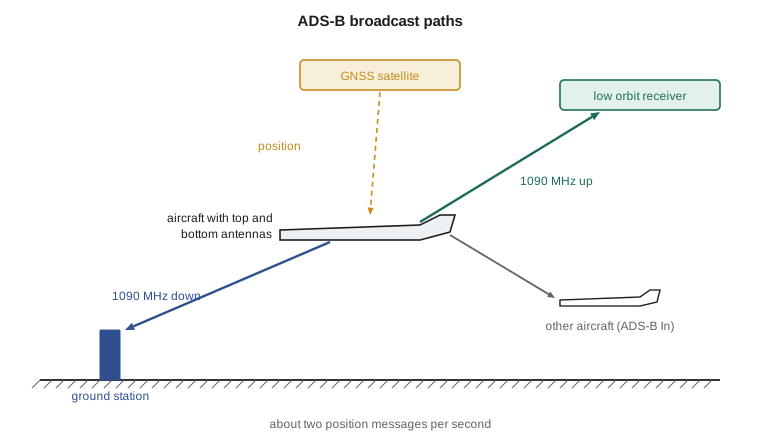
Automatic dependent surveillance-broadcast, ADS-B, turns surveillance around. Instead of a radar measuring the aircraft, the aircraft determines its own position, usually by GNSS, and broadcasts it, together with its identity, altitude, velocity and the accuracy and integrity of the position, about twice per second. Ground stations and other aircraft receive the broadcasts. ADS-B Out is the broadcast; ADS-B In is the ability to receive and display other aircraft's broadcasts and, in some systems, weather and flight information.
In the United States, the rules in 14 CFR 91.225 and 91.227 have required ADS-B Out since 1 January 2020 in most controlled airspace where a transponder is required, including Class A, B and C airspace and above 10 000 ft. Aircraft flying in Class A must use 1090 MHz extended squitter, 1090ES; below 18 000 ft the alternative universal access transceiver on 978 MHz is permitted. The rules set performance minimums: the position must meet a navigation accuracy category, NACp, of at least 8, meaning a 95 percent horizontal error below about 93 m, with matching integrity and source integrity levels.
Canada's approach uses space-based ADS-B, with receivers carried on a constellation of low Earth orbit satellites, which covers the vast areas of the country where ground stations would be impractical. the FAA Air Traffic Organization began requiring ADS-B Out in Class A airspace on 10 August 2023 and in Class B airspace on 16 May 2024, with Class C, D and E airspace to follow no sooner than 2026. The equipment must meet the DO-260B standard or later on 1090ES, and because the receivers are above the aircraft, the antenna installation must transmit upward: either a top and bottom antenna, called antenna diversity, or a single antenna able to radiate both up and down.
# Communication and surveillance: VHF radio horizon, a 1090 MHz ADS-B link budget to a satellite
# receiver, and how often a position report gets through. Link values are illustrative.
import math
def horizon_nm(h1_ft, h2_ft=0.0):     # standard radio-horizon rule for VHF/UHF line of sight
    return 1.23 * (math.sqrt(h1_ft) + math.sqrt(h2_ft))
for h in (1000, 10000, 41000):
    print(f"VHF range from {h:6d} ft to a ground antenna at 50 ft: about {horizon_nm(h, 50):4.0f} NM")
# ADS-B 1090ES, aircraft to a low Earth orbit receiver about 780 km up, slant range up to about 3000 km
f, c = 1090e6, 299792458.0
P_tx = 10 * math.log10(200)           # 200 W transmitter in dBW
G_tx, G_rx, losses = 0.0, 6.0, 4.0    # top antenna gain dBi, satellite antenna gain dBi, cable and pointing dB
sens = -142.0                         # receiver sensitivity dBW (about -112 dBm), illustrative
for d_km in (780, 1500, 3000):
    fspl = 20 * math.log10(4 * math.pi * d_km * 1e3 * f / c)
    pr = P_tx + G_tx + G_rx - losses - fspl
    print(f"slant {d_km:5d} km: path loss {fspl:5.1f} dB, received {pr:6.1f} dBW, margin {pr - sens:5.1f} dB")
# Position messages are sent about twice a second; if each gets through with probability p,
# the chance of no update within T seconds is (1-p)^(2T)
for p in (0.3, 0.6, 0.9):
    T = 8.0
    print(f"per-message success {p:.1f}: chance of no position update in {T:.0f} s = {(1-p)**(2*T):.1e}")
# Accuracy categories the rules use: NACp 8 means 95 % horizontal position error below 92.6 m
nacp = {7: 185.2, 8: 92.6, 9: 30.0, 10: 10.0}
err95 = 6.5
best = max(k for k, v in nacp.items() if err95 < v)
print(f"\nGNSS 95 % error {err95} m -> broadcasts NACp {best} (rule minimum is 8)")VHF range from 1000 ft to a ground antenna at 50 ft: about 48 NM VHF range from 10000 ft to a ground antenna at 50 ft: about 132 NM VHF range from 41000 ft to a ground antenna at 50 ft: about 258 NM slant 780 km: path loss 151.0 dB, received -126.0 dBW, margin 16.0 dB slant 1500 km: path loss 156.7 dB, received -131.7 dBW, margin 10.3 dB slant 3000 km: path loss 162.7 dB, received -137.7 dBW, margin 4.3 dB per-message success 0.3: chance of no position update in 8 s = 3.3e-03 per-message success 0.6: chance of no position update in 8 s = 4.3e-07 per-message success 0.9: chance of no position update in 8 s = 1.0e-16 GNSS 95 % error 6.5 m -> broadcasts NACp 10 (rule minimum is 8)
The link budget shows why the top antenna matters. A 200 W transmitter on a top antenna reaches a receiver at 780 km with about 16 dB of margin, and at a 3000 km slant range near the edge of the satellite's view with about 4 dB. A bottom-only antenna would lose most of that margin because the aircraft's own fuselage blocks the upward path. Even with low margin, frequent messages make up for missed ones: if only 30 percent of individual messages get through, the chance of no position update in 8 seconds is about one in three hundred, and at 60 percent it becomes negligible. A typical certified GNSS position with a 95 percent error of 6.5 m supports NACp 10, well above the minimum.
| System | Frequency | What it provides | Notes |
|---|---|---|---|
| VHF voice | 118 to 137 MHz | ATC and company voice | Line of sight |
| HF voice and data | 2.8 to 22 MHz | Long-range communication | Ionospheric, variable quality |
| Satellite communication | Various L-band and other bands | Voice and data almost anywhere | Increasingly used by small aircraft |
| Mode S transponder | 1030 MHz interrogation, 1090 MHz reply | Identity, altitude, selective addressing | Required in most controlled airspace |
| ADS-B Out 1090ES | 1090 MHz | Broadcast position, velocity and identity | Required by rules in both countries |
| UAT | 978 MHz | ADS-B in the United States below 18 000 ft | Also carries traffic and weather broadcasts |
| Emergency locator transmitter | 406 MHz | Distress beacon detected by satellites | 121.5 MHz homing signal as well |
Integrity, security and the Tern
ADS-B depends on GNSS, so the GNSS integrity monitoring of Lesson 9 also protects surveillance: if the receiver detects that its position cannot be trusted, the broadcast's integrity values drop and controllers see the aircraft as degraded. Because ADS-B messages are not encrypted, there has been concern that false messages could be injected. Defenses are at the system level: ground systems compare ADS-B positions with radar and with multilateration, which locates aircraft from the time differences of their transponder replies at several receivers, and treat inconsistent reports as suspect. Crews and controllers are trained to report anomalies. Aircraft designers do not need to defend against such threats themselves, but they must make sure that the aircraft's own broadcasts are correct and that failures are annunciated.
For the Tern, Arjun's surveillance architecture includes a Mode S transponder with 1090ES ADS-B Out, top and bottom antennas to meet the space-based requirements, ADS-B In for traffic awareness on uncontrolled strips, a satellite data link and an emergency locator transmitter. The ELT broadcasts on 406 MHz to the Cospas-Sarsat satellites, with a 121.5 MHz homing signal for searchers, and newer units can include the aircraft's position in their message. On the long, remote legs the Tern is designed for, these are not luxuries.
Electromagnetic compatibility
An aircraft carries many transmitters and receivers close together, plus the high-voltage power electronics of Lesson 2, which switch hundreds of amperes thousands of times per second. Electromagnetic compatibility testing checks that nothing interferes with anything else: that the propulsion inverters do not raise the noise floor of the VHF receivers, that the satellite terminal does not desensitize the GNSS receiver, and that the aircraft's systems survive high-intensity radiated fields from ground radars and transmitters. Antenna placement is decided early, with separation between transmitters and sensitive receivers, and verified in ground tests with all systems running.
Worked problem
Radio horizon
An aircraft at 5000 ft calls a ground station whose antenna is at 100 ft. Estimate the line-of-sight range.
Show solution
- \(1.23(\sqrt{5000} + \sqrt{100}) = 1.23(70.7 + 10) = 99\) NM.
Answer: About 100 NM in flat terrain.
Worked problem
Free-space path loss
Find the free-space path loss at 1090 MHz over 1000 km.
Show solution
- \(20\log_{10}(4\pi d f/c) = 20\log_{10}(4\pi \times 10^6 \times 1.09\times10^9/3\times10^8) = 20\log_{10}(4.57\times10^7) = 153.2\) dB.
Answer: About 153 dB.
Worked problem
Missed updates
Messages arrive twice per second, each with probability 0.5. What is the chance of receiving none in 5 seconds?
Show solution
- Ten messages; \(0.5^{10} = 9.8\times10^{-4}\).
Answer: About one in a thousand.
Where surveillance is heading
Surveillance and communication keep changing. Space-based ADS-B now lets controllers in both countries see aircraft over oceans and northern areas that radar never covered, allowing reduced separation and more efficient routes. Data link is moving to newer, faster networks, and voice is increasingly carried over internet-style networks between ground facilities. Remote towers, in which controllers watch an airport through high-definition cameras from a distant center, have begun to serve smaller airports. For the systems engineer, each of these changes adds requirements to the aircraft's equipment list, and the equipment must be certified to the standards that the air navigation service provider and the FAA reference, with software at the levels Lesson 12 describes.
Common mistakes
MistakeAssuming VHF works at any range at altitude.
InsteadIt is line of sight and limited by the radio horizon and terrain.
MistakeInstalling only a bottom ADS-B antenna for Canadian airspace.
InsteadSpace-based reception needs an antenna that transmits upward.
MistakeIgnoring a TCAS resolution advisory because of a controller's instruction.
InsteadCrews must follow the advisory promptly.
MistakeTreating ADS-B accuracy as fixed.
InsteadThe broadcast's accuracy and integrity categories depend on the GNSS solution at that moment.
Summary and key terms
- Aircraft communicate by line-of-sight VHF, long-range HF and satellite links, with data link such as CPDLC replacing routine voice.
- Secondary radar and Mode S transponders give identity and altitude, and TCAS II uses them to resolve collision threats.
- ADS-B Out broadcasts GNSS position about twice per second; the United States has required it since 2020, and Canada's space-based system requires it in Class A since 2023 and Class B since 2024, with an upward-transmitting antenna.
- Link budgets and frequent messages give reliable reception, and system-level cross-checks guard against false reports.
- CPDLC
- Controller-pilot data link communications, text exchange of clearances and requests.
- Mode S
- A transponder mode with a unique 24-bit aircraft address and selective interrogation.
- TCAS II
- An airborne collision avoidance system that issues traffic and resolution advisories.
- ADS-B Out
- The automatic broadcast of an aircraft's own position, velocity and identity.
- NACp
- Navigation accuracy category for position, a code for the 95 percent position error.
- Antenna diversity
- Top and bottom antennas used together so broadcasts reach both ground and satellite receivers.
Practice problems
Work each problem on paper first, then reveal the answer to check.
In the program, what VHF range does an aircraft at 25 000 ft have to a 50 ft antenna?
Show answer
About 203 NM.
In the program, cut the transmitter power to 125 W. What margin remains at a 3000 km slant range?
Show answer
About 2.3 dB.
Which frequency do transponders reply on?
Show answer
1090 MHz.
When did Canada begin requiring ADS-B Out in Class A airspace?
Show answer
10 August 2023.
What NACp value does the US rule require at minimum?
Show answer
8.
Why does the Tern carry a satellite data link?
Show answer
VHF coverage is patchy on its remote routes.
Lesson quiz · 5 questions
Score 60% or more to complete this lesson.
Create a free account to save your progress, take quizzes and earn a certificate.