
PHOT-350 · Lesson 4 of 12 · 30 min
Airspace, flight planning and risk assessment
Most drone accidents and violations begin before take-off. A pilot who did not notice the nearby heliport, did not read the wind forecast, missed a temporary closure or never looked at where the power lines ran has already made the mistake; the flight just reveals it. Professional aerial photographers spend more time planning than flying. This lesson covers how airspace is organized, how to check it, how to read the weather information pilots use, how to survey a site and assess risk, and how to turn all of that into a written flight plan and checklist. The goal is a routine that is thorough but quick enough to use on every job.
How airspace is organized
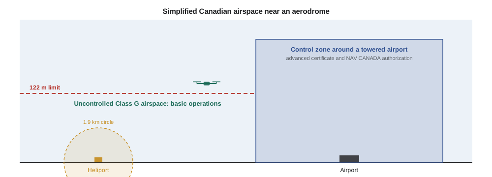
Airspace is divided into classes that set which services air traffic control provides and what pilots must do. In both Canada and the United States, Class A is high-altitude airspace used by airliners, far above drones. Lower down, airspace around busy airports is controlled, meaning air traffic control separates aircraft and drones need authorization to enter. Away from airports, low-level airspace is usually uncontrolled, Class G, where no air traffic control service is provided and drones may fly within the rules without authorization. Between these lie areas such as control zones around smaller airports, terminal areas, and corridors used by aircraft approaching and leaving runways.
In Canada, NAV CANADA provides air navigation services. Controlled airspace near the ground includes control zones around airports with control towers, typically Class C or D, extending from the surface upward. Class E airspace also exists and may start at the surface around some airports without towers. Drones must not enter controlled airspace without the advanced certificate and a NAV CANADA authorization. There are also restricted and advisory areas, such as military ranges, national defence sites and some prisons, shown on aeronautical charts and in the Designated Airspace Handbook. Transport Canada's guidance points pilots to tools such as the NAV Drone app, which shows airspace and handles authorization requests, and the National Research Council's Drone Site Selection Tool, which displays airspace and aerodromes on a map. Aerodromes include not only airports but also heliports at hospitals, water aerodromes on lakes and small private strips, many of which are listed in the Canada Flight Supplement and Water Aerodrome Supplement.
NOTAMs and temporary restrictions
Airspace changes from day to day. NOTAMs (notices to air missions, formerly to airmen) announce closures, hazards and changes, such as a crane near an airport, a temporary restricted area around a forest fire, a military exercise or an air show. Forest fire areas in particular are restricted under the CARs, and flying a drone near a wildfire is dangerous and illegal because it can ground firefighting aircraft. NOTAMs are published by NAV CANADA and can be checked through its flight planning website and many drone apps. Pilots should check NOTAMs on the day of the flight, not just when quoting the job.
Weather for drone pilots
Weather affects safety, battery life and image quality. Key factors are wind, especially gusts; precipitation, which most drones are not sealed against; visibility and cloud base; temperature, which affects batteries and can cause icing; and light, which matters for both photography and keeping the drone in sight.
Wind is the most common limit. Wind speed usually increases with height, so a breeze of 15 km/h at the ground may be 30 km/h at 100 metres. Manufacturers list a maximum wind resistance, often around 10 to 12 m/s for small camera drones, but that is a survival figure, not a comfortable working limit. Many professionals set personal limits well below it, and lower still for precise video or mapping. Gusts are more dangerous than steady wind because they can push the drone suddenly toward obstacles and drain batteries as the aircraft fights to hold position. Flying downwind away from the launch point is risky: the return trip into the wind takes longer and uses more battery.
Pilots use aviation weather products as well as general forecasts. A METAR is a routine report of current weather at an airport; a TAF is a terminal aerodrome forecast covering the next 24 to 30 hours. Both use a compact code. Reading them at an awareness level helps a drone pilot understand wind, visibility, cloud and gusts near the job.
NAV CANADA publishes METARs and TAFs through its aviation weather website, and Environment and Climate Change Canada provides public forecasts, radar and lightning maps. In Canada, METARs give wind in knots, visibility in statute miles and temperatures in degrees Celsius, with altimeter settings in inches of mercury.
Worked problem
Reading a METAR
Decode this report: METAR CYOW 141500Z 27012G22KT 15SM FEW040 BKN090 08/M02 A2992.
Show solution
- CYOW is Ottawa airport; 141500Z means the 14th day at 1500 UTC.
- 27012G22KT: wind from 270 degrees (west) at 12 knots, gusting 22 knots.
- 15SM: visibility 15 statute miles.
- FEW040 BKN090: a few clouds at 4,000 ft, broken layer at 9,000 ft.
- 08/M02: temperature 8 °C, dew point −2 °C. A2992: altimeter 29.92 inches.
Answer: Gusts of 22 knots are about 11 m/s, near many small drones' maximum wind rating, and stronger aloft. This is a poor day for precise drone work.
Cold weather deserves special attention. Lithium batteries lose capacity and voltage in the cold, and a battery that shows 40 percent can drop suddenly under load. Batteries should be kept warm until use, the drone should hover briefly after take-off so the battery warms, and flights should be shorter. Freezing drizzle or fog can ice propellers, which reduces lift dangerously. In hot weather, batteries and motors can overheat, and density altitude rises, so propellers produce less thrust in thin, hot air, especially at high-elevation sites.
The site survey
Canadian rules require pilots to carry out a site survey before flying, to identify hazards and confirm the operation can be done safely. The survey covers the boundaries of the operating area, the type of airspace and nearby aerodromes, the location and height of obstacles such as buildings, towers and power lines, the predicted weather, the distances to bystanders and the people likely to be present, and possible areas for emergency landing.
A survey can begin on a computer using satellite imagery, street views, airspace maps and terrain data, but it should be confirmed on arrival, because satellite images can be years old. Common surprises include new buildings or cranes, guy wires on towers, trees that have grown, and events such as markets or sports games that bring crowds. The launch and landing area should be flat, clear of people and away from metal structures that can affect the compass.
| Survey item | What to check | Typical sources |
|---|---|---|
| Airspace | Class, aerodromes, restrictions, NOTAMs and temporary closures | NAV Drone, NRC Drone Site Selection Tool, NAV CANADA |
| Obstacles | Buildings, towers, wires, trees, cranes and their heights | Satellite imagery, site visit, client drawings |
| People | Bystanders, crowds, schools, roads | Site visit, client schedule, local events |
| Weather | Wind and gusts aloft, precipitation, visibility, temperature | METAR, TAF, public forecasts, apps |
| Ground | Launch and landing area, emergency landing spots | Site visit |
| Permissions | Landowner, park or municipal permits, client sign-off | Contracts, permit offices |
Assessing risk
Risk combines how likely something is to go wrong with how bad the result would be. A simple risk matrix scores each hazard for likelihood and severity, multiplies them and ranks the results. High scores need mitigation before flight: changing the flight path, adding a visual observer, choosing a different time, using a lighter drone, closing off an area or not flying.
Worked problem
Scoring hazards for a waterfront wedding
A photographer scores hazards on 1 to 5 scales. Gusty wind off the lake: likelihood 4, severity 3. Guests wandering under the flight path: likelihood 3, severity 5. Losing signal behind a building: likelihood 2, severity 3. Which hazards need action first, and what could reduce them?
Show solution
- Wind: 4 × 3 = 12.
- Guests: 3 × 5 = 15.
- Signal loss: 2 × 3 = 6.
- Rank: guests (15), wind (12), signal loss (6).
- Mitigations: ask the planner for a guest-free zone and a spotter; set a wind limit and fly upwind of guests; set return-to-home altitude above the building.
Answer: Deal first with guests under the flight path, then wind; signal loss is lower risk but still needs a correct failsafe setting.
For operations that need an SFOC or fall under the newer beyond-visual-line-of-sight rules, Transport Canada expects a structured risk assessment based on the Specific Operations Risk Assessment (SORA) method developed by the international JARUS group. SORA considers the ground risk, meaning who could be hurt below the flight, and the air risk, meaning the chance of encountering crewed aircraft, then assigns mitigations and a level of assurance. A photographer doing routine basic or advanced flights does not need a full SORA, but borrowing its logic of ground risk and air risk improves everyday planning.
Turning planning into a flight plan
The result of planning should be a short written plan the pilot and any crew can follow. It includes the location and coordinates, the airspace and any authorization, the date and time window, the weather limits that will cancel or pause the flight, the take-off and landing points, the planned flight paths and altitudes, the shots or mapping blocks, the battery plan, crew roles, emergency procedures and contacts, and any permissions. For mapping, the plan adds the flight lines, altitude, overlap and ground control points (lesson 8).
Worked problem
Planning flight time against wind
A drone cruises at 12 m/s in still air. The photographer plans to fly 1.2 km downwind to a shoreline, take 6 minutes of images and return. The wind is 6 m/s. How long does the round trip take, ignoring climb and descent?
Show solution
- Downwind ground speed: 12 + 6 = 18 m/s, so 1,200 ÷ 18 ≈ 67 s.
- Upwind ground speed: 12 − 6 = 6 m/s, so 1,200 ÷ 6 = 200 s.
- Transit total: 67 + 200 ≈ 267 s ≈ 4.5 minutes.
- Plus 6 minutes on station gives about 10.5 minutes, before reserves.
Answer: About 10.5 minutes; the return leg takes three times as long as the outbound leg, so start the return with plenty of battery.
Checklists turn plans into consistent actions. A typical sequence uses a pre-departure checklist at the office (batteries charged, firmware updated, airspace checked, permissions in hand), an on-site checklist (site confirmed, crew briefed, take-off area clear), a pre-flight checklist (propellers, battery seated, gimbal free, home point recorded, failsafe set) and a post-flight checklist (log the flight, inspect for damage, store batteries correctly). Lesson 5 covers the flying procedures in detail.
When not to fly
Good planning sometimes ends with a decision not to fly. Reasons include wind beyond personal limits, rain, poor visibility, a temporary closure, unexpected crowds, a client pushing for an unsafe or illegal shot, or a pilot who is tired or unwell. Professionals build this possibility into contracts and schedules with weather days and rescheduling clauses (lesson 11). Clients respect a pilot who postpones safely far more than one who crashes into their building.
Many professional operators finish planning with a short crew briefing on site, even when the crew is only the pilot and one observer. The briefing covers the plan and its limits in a few minutes: the airspace and any authorization, the weather limits that will pause the flight, the take-off and landing points, the return-to-home altitude, the shots or mapping blocks in order, who watches for aircraft and people, the agreed calls, and what each person does in an emergency or if the link is lost. Saying the plan out loud often reveals gaps, such as an unassigned task or a landing spot that has filled with cars, and it gives the observer permission to speak up if something looks wrong.
Common mistakes
MistakeChecking airspace only when quoting the job.
InsteadRecheck airspace, NOTAMs and temporary restrictions on the day of the flight.
MistakeUsing ground-level wind to judge conditions at 100 m.
InsteadExpect stronger wind and gusts aloft, and set conservative personal limits.
MistakeFlying downwind until the battery reaches half.
InsteadPlan the return into the wind and start back with generous reserve.
MistakeRelying on old satellite images for obstacles.
InsteadConfirm obstacles such as cranes and wires on site before flying.
MistakeTreating the flight plan as paperwork.
InsteadUse the plan and checklists to brief the crew and make decisions in the field.
Summary and key terms
- Airspace near airports is controlled and needs authorization; most low-level airspace away from airports is uncontrolled.
- Canadian pilots use NAV Drone, the NRC Drone Site Selection Tool and NAV CANADA NOTAMs.
- Wind and gusts, precipitation, visibility, cloud and temperature all affect drone safety.
- METARs report current airport weather and TAFs forecast it, in a compact code.
- A site survey identifies airspace, obstacles, people, weather, landing areas and permissions.
- Risk equals likelihood times severity; high scores need mitigation or cancellation.
- Written flight plans and checklists make planning repeatable, and sometimes the right decision is not to fly.
Practice problems
Work each problem on paper first, then reveal the answer to check.
What is the main difference between controlled and uncontrolled airspace for drones?
Show answer
Controlled airspace needs authorization; uncontrolled airspace does not, within the rules.
Decode 31015G25KT.
Show answer
Wind from 310 degrees at 15 knots, gusting 25 knots.
Convert 20 knots to m/s.
Show answer
20 × 0.514 ≈ 10.3 m/s.
Why are gusts more dangerous than steady wind?
Show answer
They push the drone suddenly and drain the battery as it fights to hold position.
Give two effects of cold on drone batteries.
Show answer
Reduced capacity and sudden voltage drops under load.
A hazard has likelihood 2 and severity 5. What is its score?
Show answer
10.
Why should NOTAMs be checked on the day of the flight?
Show answer
Closures and hazards can appear at short notice, such as fires or events.
A drone flies 800 m upwind at a ground speed of 5 m/s. How long does it take?
Show answer
160 s, about 2.7 minutes.
What does SORA separate?
Show answer
Ground risk and air risk.
Name three reasons to cancel a flight on site.
Show answer
Excess wind, rain or poor visibility, unexpected crowds, a temporary closure or a tired pilot.
Lesson quiz · 5 questions
Score 60% or more to complete this lesson.
Create a free account to save your progress, take quizzes and earn a certificate.