
PET-200 · Lesson 2 of 12 · 19 min
Petroleum geology and the petroleum system
Before Prairie Crest drills its new section to the north, its geologists must convince Lena and the managers that oil is likely to be there. Their argument rests on the petroleum system, a set of conditions that all have to be met for oil or gas to accumulate in a place where a well can reach it. The Tamarack Lake field exists because organic-rich mud was buried and heated deep enough to make oil, the oil moved upward into a porous sandstone, and something stopped it from escaping to the surface. If any one of those links is missing at the new location, the well will be dry, whatever the engineering. This lesson introduces the geology a petroleum engineer needs to read a prospect, and PET-210 Petroleum Geology develops it in depth.
Where oil and gas come from
Almost all oil and natural gas formed from the remains of microscopic plants and animals, mostly algae and plankton, that settled on the floors of ancient seas and lakes. Where the bottom water had little oxygen, the organic matter was not eaten or oxidized, and it was buried with fine mud. Over millions of years, more sediment piled on top, and the mud became shale. A rock rich in this preserved organic matter, typically with 2 to 10 percent organic carbon by weight, is called a source rock. Its organic matter, called kerogen, is a solid, waxy material that does not flow.
Heat turns kerogen into petroleum. Temperature rises with depth at a rate called the geothermal gradient, typically 25 to 35 degrees Celsius per kilometre in sedimentary basins. As a source rock is buried deeper and heated, its kerogen begins to crack into liquid oil at roughly 60 to 70 °C. This range, up to about 120 to 150 °C, is called the oil window. Hotter still, the oil itself cracks into lighter molecules and eventually into methane, the gas window, which extends to about 200 to 225 °C. Beyond that, the rock is overcooked and holds only dry gas or carbon. Time matters too: a source rock heated briefly may produce less than one held at the same temperature for tens of millions of years.
The type of kerogen decides what comes out. Marine algae make kerogen rich in hydrogen that yields mostly oil. Woody land plants make kerogen poor in hydrogen that yields mostly gas, and coal is the extreme case. In the Western Canada Sedimentary Basin, the Duvernay and Exshaw shales, the Second White Specks shale and the Nordegg are important source rocks; the oil in the Cardium sandstones came from marine shales above and below them.
# Depth of the oil and gas windows for different geothermal gradients
T_SURFACE = 8.0                      # mean surface temperature, deg C
OIL_TOP, OIL_BASE, GAS_BASE = 65.0, 140.0, 220.0   # deg C, typical values

def depth_km(temp_c, gradient):
    return (temp_c - T_SURFACE) / gradient

print("gradient    oil window (km)    gas window base (km)")
for g in (20, 25, 30, 35, 45):
    top, base, gb = (depth_km(t, g) for t in (OIL_TOP, OIL_BASE, GAS_BASE))
    print(f"{g:3d} C/km   {top:4.1f} to {base:4.1f}         {gb:5.1f}")

# Oilfield units: 1 C/km = 0.0549 F per 100 ft; 1 km = 3281 ft
g = 30
print(f"\nAt {g} C/km ({g * 0.0549:.2f} F per 100 ft) the oil window runs from "
f"{depth_km(OIL_TOP, g) * 3281:,.0f} to {depth_km(OIL_BASE, g) * 3281:,.0f} ft")gradient oil window (km) gas window base (km) 20 C/km 2.9 to 6.6 10.6 25 C/km 2.3 to 5.3 8.5 30 C/km 1.9 to 4.4 7.1 35 C/km 1.6 to 3.8 6.1 45 C/km 1.3 to 2.9 4.7 At 30 C/km (1.65 F per 100 ft) the oil window runs from 6,234 to 14,436 ft
The program shows why the same source rock can make oil in one basin and gas in another. In a hot basin with a steep gradient, the oil window is shallow and thin; in a cool basin it is deep and wide. Geologists calibrate the gradient with temperatures measured in wells and with laboratory measurements on the source rock, then model the burial history to estimate when oil was generated and whether a trap had formed by then.
The elements of a petroleum system
Geologists describe a petroleum system with four elements and two processes. The elements are the source rock, the reservoir rock, the seal and the overburden that buried the source rock deep enough. The processes are trap formation and the generation, migration and accumulation of petroleum. Timing ties them together: the trap must exist before the oil moves past it, or the oil will escape.
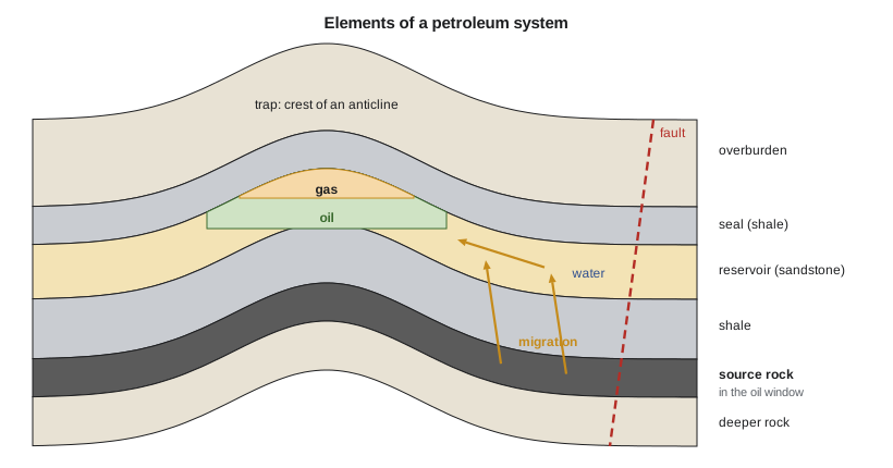
A reservoir rock is any rock with enough pore space to hold fluids and enough connected pores to let them flow. Sandstones and carbonates such as limestone and dolomite make most reservoirs. Sandstones are made of sand grains with spaces between them; carbonates often have pores created by dissolving minerals and fractures. Lesson 3 defines the two properties that matter most: porosity, the fraction of the rock that is pore space, and permeability, the ease with which fluid flows through it.
A seal, or cap rock, is a layer with pores so small that oil and gas cannot push through it. Shales, salt and anhydrite make the best seals. Petroleum is lighter than water, so once generated it moves upward through the water-filled pores of the rocks above, a process called migration. Primary migration is the escape of oil from the source rock itself; secondary migration is its movement along porous carrier beds and faults. Most of the oil ever generated has migrated all the way to the surface and been lost, forming tar seeps and oil sands where it was trapped close to the surface and degraded by bacteria.
Traps
A trap is a configuration of reservoir and seal that stops migrating petroleum. Structural traps are formed by folding or faulting of the rock layers. The classic example is an anticline, an upward fold shaped like an upturned bowl; oil rises to the crest and is held there by the seal above. Fault traps form where a fault places a sealing rock against the reservoir. Salt domes push up through overlying layers and create traps on their flanks. Stratigraphic traps are formed by changes in the rock itself: a sandstone that pinches out into shale, a buried reef surrounded by impermeable mud, or an erosion surface covered by a seal. Many traps combine both.
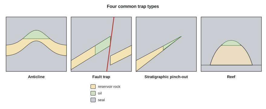
The Tamarack Lake field is a stratigraphic trap. The Cardium sandstones and conglomerates were deposited as long, narrow shoreline bodies about 90 million years ago, and they grade updip into marine shale, which seals them. Oil migrated into the sand bodies and stopped where the sand ended. Pools like this are hard to find with seismic because there is no fold to see; geologists map them from thousands of well logs instead. The largest conventional oil pool in Canada, the Pembina field, is a Cardium pool of the same type.
Conventional and unconventional resources
Engineers distinguish conventional from unconventional accumulations. In a conventional accumulation, oil or gas has migrated into a trap in a permeable reservoir, the fluids are separated by density with gas over oil over water, and vertical wells can produce at good rates with little stimulation. An unconventional accumulation is spread through a rock of very low permeability, such as a shale or a tight sandstone, and it covers a large area with no sharp boundary. It needs horizontal wells and hydraulic fracturing, described in Lesson 6, to produce economically. Oil sands are also counted as unconventional: the bitumen is too viscous to flow at reservoir temperature and must be mined or heated.
Western Canada has examples of every kind. Conventional pools in Devonian reefs, such as Leduc and Redwater, started the modern industry in 1947. Tight and shale plays such as the Montney, Duvernay and Cardium are developed with long horizontal wells. The oil sands of northern Alberta hold one of the largest oil resources in the world, roughly 160 billion barrels of remaining established reserves by recent estimates.
Worked problem
Will the source rock have made oil?
The source shale under the northern section lies at 2,350 m. The surface temperature averages 5 °C and the geothermal gradient measured in nearby wells is 30 °C/km. Taking the oil window as 65 to 140 °C, is the shale in the oil window today?
Show solution
- Temperature at depth: T = 5 + 30 × 2.35 = 5 + 70.5 = 75.5 °C.
- Compare with the window: 65 °C < 75.5 °C < 140 °C.
- Depth of the window's top: (65 − 5)/30 = 2.0 km; bottom: (140 − 5)/30 = 4.5 km.
Answer: Yes. At about 76 °C the shale is in the upper part of the oil window, consistent with the light oil found in the field. If it had been buried deeper in the past and later uplifted, it could have generated more than its present temperature suggests.
Fluids in the reservoir
A reservoir is never filled with oil alone. Its pores were full of salty water before the oil arrived, and some water always remains, coating the grains and filling the smallest pores. In a conventional trap, the fluids sort themselves by density. Free gas, if there is enough of it, forms a gas cap at the top. Oil sits below, and water fills the rock beneath the oil. The boundaries are called the gas-oil contact and the oil-water contact. The contacts are not perfectly sharp; capillary forces create a transition zone a few metres thick where water saturation changes gradually with height.
Oil composition varies widely. Light oils have a low density and flow easily; heavy oils are dense and viscous. The industry measures density with API gravity, a scale on which water is 10 degrees and lighter oils have higher numbers. Light crude is roughly above 31° API, heavy crude below 22°, and bitumen below 10°. Oils also contain dissolved gas, which comes out of solution as pressure drops during production, as Lesson 3 explains. Some contain hydrogen sulphide, which makes the oil sour and the gas toxic and corrosive, and requires special materials and safety measures.
Reading well logs and cores
Petroleum engineers spend a surprising amount of time looking at well logs, the continuous records of rock properties measured along a borehole. A gamma ray log distinguishes shales, which are rich in naturally radioactive potassium, thorium and uranium, from cleaner sandstones and carbonates. Resistivity logs show where pores hold oil or gas instead of salty water. Density and neutron logs measure porosity, and where gas is present the two curves separate in a characteristic way. Geologists correlate the logs from well to well to map how the reservoir thickens, thins and changes, and engineers use the same correlations to choose where to land a horizontal well.
Cores, cylinders of rock cut with a special hollow bit, show what the logs only infer: grain size, layering, fractures, fossils and the oil staining itself. Laboratory tests on core plugs measure porosity, permeability, saturation and rock strength, and they calibrate the log interpretation for the whole field. Cuttings from every well give a coarser record. Together, logs and cores turn a geological model into numbers an engineer can use, as Lesson 3 shows.
Common mistakes
MistakeAssuming a good reservoir rock guarantees oil.
InsteadAll elements must be present: source, reservoir, seal, trap and correct timing. Many porous sandstones hold only water.
MistakeThinking oil forms in the rock where it is found.
InsteadIn conventional fields oil usually migrated from a source rock elsewhere. In shale plays, the source and the reservoir are close together or the same rock.
MistakeTreating hotter as always better for oil.
InsteadAbove the oil window, oil cracks to gas. Overmature source rocks yield dry gas only.
MistakeExpecting a sharp oil-water contact.
InsteadCapillary forces create a transition zone where water saturation changes over a vertical interval.
Summary and key terms
- Oil and gas form from organic matter in source rocks heated in the oil window (about 60 to 150 °C) and gas window (to about 225 °C).
- A petroleum system needs a source rock, reservoir, seal and overburden, plus trap formation and migration in the right order.
- Traps are structural (anticlines, faults, salt), stratigraphic (pinch-outs, reefs, unconformities) or combined.
- Conventional accumulations sit in traps in permeable rock; unconventional ones spread through tight rock and need horizontal wells and fracturing.
- In a trap, gas, oil and water separate by density, with transition zones at the contacts.
- API gravity measures oil density; higher numbers mean lighter oil.
- Source rock
- A fine-grained rock rich in organic matter that generates oil or gas when heated.
- Kerogen
- The solid organic matter in a source rock that cracks into oil and gas when heated.
- Oil window
- The temperature range, roughly 60 to 150 °C, in which kerogen generates oil.
- Migration
- The movement of oil and gas from the source rock into carrier beds and traps.
- Seal
- A low-permeability layer, such as shale or salt, that stops petroleum from rising further.
- Trap
- A configuration of reservoir and seal that holds migrating petroleum in place.
- API gravity
- A scale of oil density on which water is 10 degrees and lighter oils have higher values.
Practice problems
Work each problem on paper first, then reveal the answer to check.
A source rock lies at 3,100 m with a surface temperature of 8 °C and a gradient of 25 °C/km. What is its temperature, and is it in the oil window (65 to 140 °C)?
Show answer
T = 8 + 25 × 3.1 = 85.5 °C; yes, in the oil window.
List the four elements and two processes of a petroleum system.
Show answer
Elements: source rock, reservoir rock, seal, overburden. Processes: trap formation; generation, migration and accumulation.
Why are stratigraphic traps harder to find than anticlines?
Show answer
They have no structural closure to image on seismic; they depend on subtle changes in rock type that must be mapped from well data and detailed seismic attributes.
An oil has a specific gravity of 0.83. Its API gravity is 141.5/0.83 − 131.5. Calculate it and classify the oil.
Show answer
141.5/0.83 − 131.5 = 39.0° API, a light oil.
Lesson quiz · 5 questions
Score 60% or more to complete this lesson.
Create a free account to save your progress, take quizzes and earn a certificate.