
GEOM-310 · Lesson 11 of 12 · 23 min
Drone photogrammetry
The construction contract required a topographic survey of the headworks excavation every two weeks, a stockpile volume every month, and an orthophoto of the site for each progress meeting. Coulee Geomatics would do them all with its survey drone. Grant had flown drones for years, but always by eye and for pictures; Ruth wanted the headworks flights planned, flown and controlled like any other survey, and documented to the standard the district's engineers would expect. Leah wrote the plan. This lesson covers the platforms and cameras used for drone mapping, flight planning for GSD, overlap, speed and blur, the role of ground control and of RTK and PPK positioning, the special geometry problems of drone blocks, the regulations that govern flight, and safe and considerate operation.
Platforms and sensors
Mapping drones come in three forms. Multirotors take off and land vertically, hover, fly slowly and are easy to operate in confined sites; their endurance is typically 20 to 45 minutes, which limits them to areas of tens to a few hundred hectares per flight. Fixed-wing drones fly like small aircraft, cover several square kilometres per flight and are efficient for corridors and farms, but need open space to launch and land. Vertical take-off and landing (VTOL) hybrids combine rotors for take-off and landing with wings for cruise. For the headworks, a 600 by 400 m site with an excavation, stockpiles and machinery, a multirotor is the natural choice.
Drone cameras range from integrated consumer cameras with 1-inch sensors to full-frame and medium-format cameras with interchangeable fixed lenses. For mapping the essential properties are those of Lesson 2: a mechanical or global shutter, fixed focus, a lens that does not move, image stabilization and in-camera distortion correction disabled, and images stored without heavy compression. The headworks camera has a 13.2 by 8.8 mm sensor of 5472 by 3648 pixels, 2.41 µm square, behind an 8.8 mm lens, with a mechanical leaf shutter. Many drones also carry lidar, multispectral or thermal sensors; the planning principles are the same.
Flight planning
A drone flight plan starts from the required GSD and the accuracy specification, and works out the flying height, the overlaps, the line spacing, the speed and the camera settings. The flying height above the ground follows from the GSD exactly as in Lesson 1, \(H = \text{GSD} \cdot f / p\). Because drones fly low, terrain relief is a much larger fraction of the flying height than for crewed aircraft: a 30 m stockpile under a drone flying 90 m above the site floor reduces the height above its top to 60 m and the GSD there by a third. Planning software can follow the terrain from a surface model, keeping the height above ground constant, which keeps GSD and overlap uniform; it needs a reliable surface model of the site and a careful check for obstacles such as cranes and power lines.
Overlaps for drone mapping are much higher than for crewed photography: typically 70 to 85 % forward and 60 to 80 % side. Several reasons combine. Consumer cameras have weaker geometry, so redundancy is needed for self-calibration. Structure from motion and dense matching work best when every point is seen in many images from different directions. Drones are buffeted by wind, which changes their attitude and footprint from photo to photo, and high overlap guarantees coverage despite it. The cost of high overlap is more photos and longer processing, which for a small site is a minor price.
Speed is limited by two things. Motion blur during the exposure must be a fraction of a pixel, usually below half a pixel, so the speed must not exceed \(0.5 \cdot \text{GSD} / t_{\text{exp}}\); a short exposure time needs bright light or a higher sensor sensitivity, which adds noise. And the camera must be able to take photos as fast as the forward overlap requires: if it can fire only every 2 seconds, the speed is limited to the photo spacing divided by 2 seconds. The program below computes both for the headworks.
# Drone flight plan for the canal headworks: height, spacing, photo count, speed limits
import math

f = 8.80e-3; pix = 2.41e-6; cols, rows = 5472, 3648      # camera (long side across track)
gsd = 0.025                                               # target GSD (m)
site_w, site_l = 400.0, 600.0                             # site: lines run along the 600 m side
fwd, side = 0.80, 0.70                                    # forward and side overlap
H = gsd * f / pix
print(f"Flying height above ground {H:.1f} m ({H / 0.3048:.0f} ft); 400 ft = 121.9 m")
across, along = cols * gsd, rows * gsd
print(f"Footprint {across:.1f} m across track x {along:.1f} m along track")
spacing = (1 - side) * across; base = (1 - fwd) * along
lines = math.ceil(site_w / spacing) + 1
per_line = math.ceil(site_l / base) + 1 + 2               # one extra photo beyond each end
print(f"Line spacing {spacing:.1f} m, {lines} lines; photo spacing {base:.2f} m, {per_line} photos per line")
print(f"Photos in the block: {lines * per_line}")

shutter = 1 / 1000; max_blur = 0.5                        # exposure time (s), allowed blur (pixels)
v_blur = max_blur * gsd / shutter
interval = 2.0                                            # fastest repeat rate of the camera (s)
v_int = base / interval
v = min(v_blur, v_int, 12.0)
print(f"Speed limits: blur {v_blur:.1f} m/s, camera interval {v_int:.1f} m/s -> fly at {v:.1f} m/s")
dist = lines * (site_l + 2 * base) + (lines - 1) * spacing
t_min = dist / v / 60 + lines * 0.25                      # 15 s per turn
print(f"Flight path {dist / 1000:.2f} km, about {t_min:.0f} min of flying")
usable = 22.0                                             # usable minutes per battery with reserve
print(f"Batteries needed (22 min usable each): {math.ceil(t_min / usable)}")

# Rolling shutter: the sensor reads out row by row in 30 ms while the drone moves
readout = 0.030
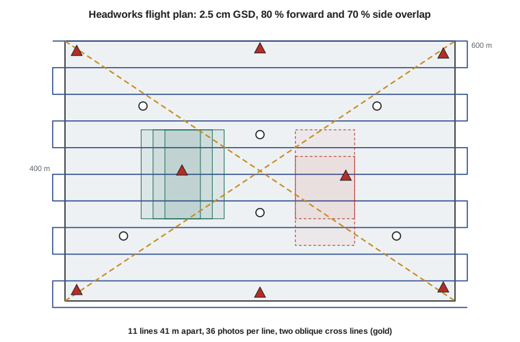
print(f"Rolling shutter: the scene moves {v * readout:.2f} m = {v * readout / gsd:.1f} pixels during readout")Flying height above ground 91.3 m (299 ft); 400 ft = 121.9 m Footprint 136.8 m across track x 91.2 m along track Line spacing 41.0 m, 11 lines; photo spacing 18.24 m, 36 photos per line Photos in the block: 396 Speed limits: blur 12.5 m/s, camera interval 9.1 m/s -> fly at 9.1 m/s Flight path 7.41 km, about 16 min of flying Batteries needed (22 min usable each): 1 Rolling shutter: the scene moves 0.27 m = 10.9 pixels during readout
A 2.5 cm GSD requires a height of 91 m above the ground, about 300 ft, comfortably below the 122 m (400 ft) limit discussed below. Eleven lines of 36 photos give 396 photos. The camera's 2-second repeat rate, not motion blur, limits the speed to about 9 m/s, and the whole block takes about 16 minutes, within one battery. The last line is a reminder of why the mechanical shutter matters: a rolling shutter reading out in 30 ms at 9 m/s would shift the bottom of each image by about 11 pixels relative to the top.
Worked problem
Choosing an exposure time
At a GSD of 2.5 cm and a ground speed of 9.1 m/s, what is the longest exposure time that keeps motion blur below one third of a pixel? If the light on a December afternoon needs 1/500 s at the lowest sensor sensitivity, what speed is allowed?
Show solution
- \[b = v\,t_{\text{exp}} \le \tfrac13 \times 0.025 = 0.00833 \text{ m}\]
- \[t_{\text{exp}} \le \frac{0.00833}{9.1} = 0.00092 \text{ s} \approx \frac{1}{1090} \text{ s}\]
- \[v \le \frac{0.00833}{1/500} = 4.2 \text{ m/s}\]
Answer: At midday a 1/1000 s exposure is easy. In low winter light, the drone must slow to about 4 m/s, more than doubling the flight time, or accept more noise by raising the sensor sensitivity.
Geometry for drone blocks
A block of parallel lines of near-vertical photos is the weakest geometry for self-calibration, as Lessons 2 and 8 explained, and is the cause of the bowl and dome deformations that afflict drone surveys. The remedies are cheap: a few additional lines flown perpendicular or diagonal to the main lines, at a different height or with the camera tilted 15 to 30° from the vertical; oblique images around the edges of the site; and ground control spread across the site, not only around its edge. Leah's plan added two diagonal lines at 110 m with the camera tilted 20° forward, taking six extra minutes.
Ground control, RTK and PPK
Drones carry navigation-grade GNSS receivers accurate to a few metres. That is enough to fly but not enough to survey, so mapping drones either rely on ground control points or carry survey-grade GNSS receivers that record carrier-phase data. With real-time kinematic (RTK) positioning, corrections from a base station or a network are received during the flight; with post-processed kinematic (PPK) positioning, the drone's raw data are processed afterward against a base station or a CORS. Either way, each photo's camera position can be known to a few centimetres, provided the exposure time is synchronized with the GNSS data and the lever arm from the antenna to the camera is applied, as in Lesson 5. PPK is more robust to radio dropouts; RTK gives immediate results.
Accurate camera positions do not remove the need for ground control altogether. They fix the scale and position of the block and greatly reduce dome deformation, but an error in the antenna offset, the base station coordinates, the datum, or the camera focal length can still shift or warp the result. Good practice for survey-grade work is a modest number of ground control points, five to ten for a site like the headworks, placed around the perimeter and near the centre and at different elevations, and a separate set of checkpoints, never used in the processing, to test the result. Targets should be large enough to be measured precisely, at least ten to twenty pixels across, with high contrast, and placed on stable ground where machinery will not move them.
| Approach | Ground control | Typical vertical accuracy at 2.5 cm GSD | Main risk |
|---|---|---|---|
| Navigation GNSS only | None | Metres | Unknown datum, scale and doming |
| Ground control only | 8 to 15 points, well distributed | A few centimetres | Poor control layout, disturbed targets |
| RTK or PPK camera positions | A few points to verify | A few centimetres | Antenna offset, timing or datum errors |
| RTK or PPK plus ground control | Five or more plus checkpoints | A few centimetres, verified | Least risk; recommended for construction surveys |
Rules for flying
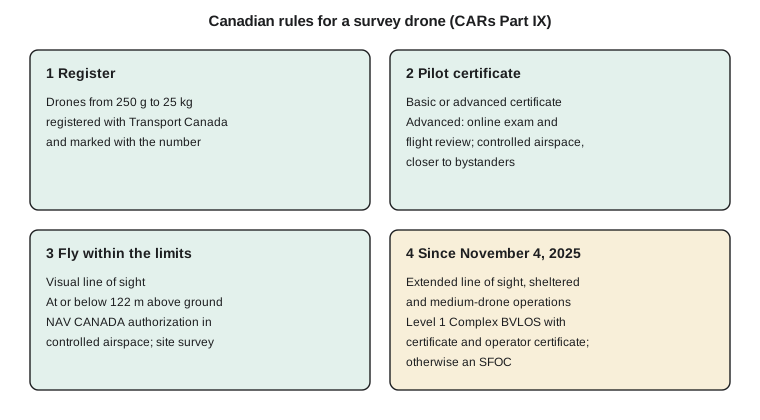
In Canada, drones are regulated under Part IX of the Canadian Aviation Regulations. Drones weighing from 250 g to 25 kg must be registered with Transport Canada and marked with their registration number, and their pilots must hold a pilot certificate for the kind of operation. Basic operations keep the drone in uncontrolled airspace and away from bystanders. Advanced operations, which include flying in controlled airspace with authorization from NAV CANADA and closer to bystanders with suitable drones, require an advanced certificate earned by an online exam and a flight review. Drones are normally flown within visual line of sight and no higher than 122 m above the ground, and the pilot must complete a site survey before flying.
The rules were broadened in 2025. Since November 4, 2025, holders of the advanced certificate may also fly extended visual line-of-sight operations, sheltered operations close to structures, and medium drones from 25 to 150 kg within visual line of sight. A new Level 1 Complex certificate, requiring a minimum age of 18, an exam, at least 20 hours of ground school and a flight review, together with an RPAS operator certificate held by the organization, allows lower-risk beyond-visual-line-of-sight flights in uncontrolled airspace away from populated areas. Operations outside these categories still need a special flight operations certificate. For a long canal corridor these changes matter: a fixed-wing drone flown beyond visual line of sight over open farmland may now be possible without a special certificate.
The headworks site lies outside controlled airspace, which Leah confirmed in NAV CANADA's drone flight planning app before each flight, along with any temporary restrictions. Grant holds an advanced certificate because the site is busy with workers and machinery, and the crew's procedures keep the drone away from people who are not part of the operation.
Operating safely and considerately
Regulations set minimums. A professional operation adds a written plan for each site: the launch and landing area, the planned lines and height, the emergency landing areas, the communication with the site superintendent and equipment operators, the weather limits for wind and precipitation, and what the pilot will do on loss of link or GNSS. Crews keep flight logs and battery records, and inspect the drone before each flight. On construction sites, cranes and excavator booms are moving obstacles; on farms, livestock, wildlife and spray aircraft share the low airspace. Privacy and trespass are real concerns: flights over neighbouring land, images of people and homes, and data storage should follow the client's agreement and applicable privacy law, and landowners along a corridor should be told when and why a drone will fly.
Weather affects data as well as safety. Wind changes the attitude of the drone from photo to photo, which high overlap compensates for; gusts beyond the drone's limits end the flight. Low sun gives long shadows that move between flights and confuse comparisons; flying near midday, with consistent light, is preferred for change detection. Snow and frost cover texture and add their own depth to stockpile volumes. The headworks surveys were scheduled for late morning and postponed when wind exceeded the limits in the plan.
Processing and deliverables
Drone processing follows the SfM-MVS pipeline of Lesson 8: alignment with self-calibration, use of the RTK or PPK camera positions and ground control in the bundle adjustment, dense matching, surface generation and orthophoto production. A processing report records the camera calibration, the reprojection error, the residuals at control points and the errors at checkpoints, and the coordinate system and datum. Deliverables for the headworks were a 2.5 cm orthophoto, a 5 cm DSM, a ground-filtered DTM with machinery removed, stockpile volumes against the agreed base surface, and a short accuracy statement. Comparing successive surveys gives cut and fill quantities for the contractor's progress payments.
Common mistakes
MistakePlanning a flight from the take-off point elevation over a site with large relief.
InsteadPlan height above the actual terrain, or follow terrain with a reliable surface model, and check obstacles.
MistakeFlying only parallel vertical lines with a self-calibrated camera.
InsteadAdd oblique or cross lines at another height to prevent doming.
MistakeRelying on RTK or PPK camera positions without any checkpoints.
InsteadUse a few control points and an independent set of checkpoints to verify each survey.
MistakeChoosing speed without checking motion blur and camera repeat rate.
InsteadCompute both limits; in low light, slow down or accept more noise.
MistakeTreating regulations as the whole of safety.
InsteadPrepare a site plan, coordinate with site staff, and respect privacy and landowners.
Summary and key terms
- Multirotor, fixed-wing and VTOL drones suit different site sizes and shapes.
- Flight planning derives height from GSD, uses high overlaps, and limits speed by motion blur and camera repeat rate.
- Cross lines, oblique images and distributed control strengthen drone blocks against doming.
- RTK or PPK camera positions reduce the need for control, but control and checkpoints still verify the result.
- In Canada, drones from 250 g to 25 kg are registered and flown by certified pilots under CARs Part IX, broadened in November 2025.
- Safe operation adds site plans, weather limits, coordination with site staff and respect for privacy.
- Processing follows SfM-MVS and delivers orthophotos, surfaces, volumes and an accuracy statement.
- Multirotor
- A drone lifted by several rotors, able to hover and take off vertically.
- RTK positioning
- Real-time kinematic carrier-phase GNSS positioning with corrections received during the survey.
- PPK positioning
- Post-processed kinematic carrier-phase GNSS positioning computed after the flight.
- Motion blur
- Smearing of the image caused by movement of the camera during the exposure.
- Terrain following
- Flying at a constant height above the ground using a surface model.
- Special flight operations certificate
- A Transport Canada authorization for drone operations outside the standard categories.
Practice problems
Work each problem on paper first, then reveal the answer to check.
A camera has f = 12.3 mm and 3.3 µm pixels. What flying height gives a 2 cm GSD?
Show answer
H = 0.02 × 0.0123 / 3.3e-6 = 74.5 m.
With a footprint of 90 m along track and 75 % forward overlap, what is the photo spacing?
Show answer
0.25 × 90 = 22.5 m.
At 1/800 s exposure and 1.5 cm GSD, what speed keeps blur below half a pixel?
Show answer
0.5 × 0.015 × 800 = 6.0 m/s.
A stockpile rises 25 m above a site flown at 80 m. What is the GSD on its top if it is 2.5 cm at the site floor?
Show answer
2.5 × 55 / 80 = 1.7 cm.
Why are checkpoints still needed with RTK camera positions?
Show answer
To detect antenna offset, timing, datum or calibration errors that the positions cannot reveal.
Lesson quiz · 5 questions
Score 60% or more to complete this lesson.
Create a free account to save your progress, take quizzes and earn a certificate.