
ROB-420 · Lesson 7 of 12 · 29 min
Drone autonomy: navigation, BVLOS, detect and avoid, delivery and inspection
A drone that can hold a hover is a flying platform; a drone that can plan a route, fly kilometers beyond its operator's sight, notice an approaching helicopter and step aside, deliver a parcel to a backyard or inspect a power line without help is an autonomous system. This lesson covers the autonomy layer above the flight controller of Lesson 6: mission planning and navigation, operation beyond visual line of sight, detect-and-avoid, and the two largest commercial applications, delivery and infrastructure inspection. Drone regulation is treated in depth in PHOT-350; here we outline only the parts that shape how autonomy is designed, and we note where rules are still changing.
Missions and navigation
Most autonomous drone missions are planned in advance as a sequence of waypoints with altitudes, speeds and actions, such as take a photo, hover or drop a payload, uploaded to the autopilot by a ground control station. Survey missions use lawnmower patterns with overlap chosen for photogrammetry; corridor missions follow linear assets such as pipelines and power lines. During flight, the autopilot navigates with GNSS and its inertial estimator, while the ground station monitors telemetry. Higher autonomy adds on-board path planning around obstacles detected by cameras or lidar, dynamic replanning when a no-fly area is activated, and contingency planning that keeps a reachable landing site available at every point of the route.
GNSS dependence is a weakness. Inspection close to steel structures, flight under bridges and indoor or underground work, such as mine inspection, deny satellite signals and can disturb the magnetometer. Visual-inertial odometry and lidar SLAM, from ROB-340, let drones navigate without GNSS. Jamming and spoofing are also growing concerns, and robust systems cross-check GNSS against inertial and visual estimates.
Worked problem
Survey mission flight time
A drone surveys a 600 m by 400 m field at 80 m altitude. Its camera footprint at that altitude is 100 m wide across track. Lines need 70 % side overlap and the drone flies at 10 m/s. Estimate the flight time, ignoring turns.
Show solution
- Line spacing: \( 100 \times (1 - 0.7) = 30 \) m.
- Number of lines across 400 m: \( 400/30 \approx 13.3 \), so 14 lines.
- Distance: \( 14 \times 600 = 8400 \) m plus about \( 13 \times 30 = 390 \) m of transitions, total about 8.8 km.
- Time: \( 8790/10 \approx 880 \) s, about 15 minutes.
Answer: About 15 minutes of flying, close to the endurance of the drone in Lesson 6, so the mission may need two batteries with a reserve, especially in cold weather.
# Uploading and flying a simple survey mission with the MAVSDK Python library (PX4 autopilot)
import asyncio
from mavsdk import System
from mavsdk.mission import MissionItem, MissionPlan

async def run():
    drone = System()
    await drone.connect(system_address="udp://:14540")      # simulator or telemetry link
    async for state in drone.core.connection_state():
        if state.is_connected:
            break
    items = []
    for lat, lon in [(45.4215, -75.6972), (45.4220, -75.6972),
                     (45.4220, -75.6962), (45.4215, -75.6962)]:
        items.append(MissionItem(lat, lon, 80, 10, True, float('nan'), float('nan'),
                                 MissionItem.CameraAction.TAKE_PHOTO, float('nan'),
                                 float('nan'), float('nan'), float('nan'), float('nan'),
                                 MissionItem.VehicleAction.NONE))
    await drone.mission.set_return_to_launch_after_mission(True)
    await drone.mission.upload_mission(MissionPlan(items))
    await drone.action.arm()
    await drone.mission.start_mission()

asyncio.run(run())
Mission listings like this one are typically tested first in software-in-the-loop simulation, where the autopilot firmware runs on a desktop computer against a simulated vehicle, before any flight. The same mission file can then be flown on hardware, with the ground station watching for failsafe events such as low battery or lost link, which trigger the return-to-launch behavior configured in the autopilot parameters.
Beyond visual line of sight
Under the basic rules in both countries, the pilot must keep the drone within visual line of sight, VLOS, unaided by binoculars. Most economically valuable missions, such as delivery, long linear inspections and large-area agriculture, require flying beyond visual line of sight, BVLOS. Once the pilot cannot see the drone or the sky around it, two functions humans normally perform must be replaced: keeping the drone clear of other aircraft, and keeping it clear of people and obstacles on the ground. Regulators therefore tie BVLOS permissions to the risk of each operation, considering airspace class, population density beneath the route, the drone's mass and reliability, and the detect-and-avoid capability.
| Item | Canada (at the time of writing, October 2026) | United States (at the time of writing, October 2026) |
|---|---|---|
| Basic rules | Canadian Aviation Regulations Part IX for drones up to 150 kg | 14 CFR Part 107 for small UAS under 55 lb |
| Routine BVLOS | Lower-risk BVLOS in uncontrolled airspace, away from aerodromes and populated areas, permitted since November 4, 2025 with a Level 1 Complex certificate and an operator certificate | Generally needs a waiver or exemption; the proposed Part 108 rule would create permits and certificates |
| Higher-risk BVLOS | Special Flight Operations Certificate | Waivers, exemptions and type certification paths |
| Rule in progress | Further phases expected | Part 108 proposed August 2025; final rule sent for federal review in July 2026; not in force |
Canada's 2025 amendments allow lower-risk BVLOS operations below 122 m in uncontrolled airspace, away from aerodromes and outside populated areas, for pilots holding a Level 1 Complex certificate whose organizations hold an operator certificate; anything more complex needs a Special Flight Operations Certificate. In the United States, the Federal Aviation Administration proposed Part 108 in August 2025 to normalize BVLOS operations under operating permits for lower-risk work and operating certificates for larger or more complex operations, with right-of-way rules relative to crewed aircraft broadcasting their position. The final rule was sent for federal review in July 2026 and, at the time of writing, has not been published and is not in force; until it is, US BVLOS operations rely on waivers and exemptions. Because these details change, always check the current rules and PHOT-350 before planning an operation.
Detect and avoid
Detect-and-avoid, DAA, replaces the pilot's ability to see and avoid other aircraft. It has three parts: surveillance, to detect traffic; threat evaluation, to decide whether a conflict will occur; and maneuver, to resolve it while respecting right-of-way. Surveillance can be cooperative, using signals that aircraft broadcast, such as ADS-B, or non-cooperative, using radar, cameras or acoustic sensors to detect aircraft that broadcast nothing, such as many small private aircraft, gliders and balloons. Ground-based radar networks can cover a whole corridor, while airborne sensors travel with the drone. The required detection range follows from closing speed and the time needed to decide and maneuver.
# Required detect-and-avoid range for different intruders
import numpy as np
drone_v = 15.0                                   # drone ground speed m/s
t_budget = 4.0 + 2.0 + 10.0                       # confirm track, decide, manoeuvre (s)
d_sep = 600.0                                     # desired miss distance (m), roughly 2000 ft
intruders = {"helicopter": 60.0, "light plane": 55.0, "glider": 30.0, "other drone": 15.0}
for name, v in intruders.items():
    v_close = drone_v + v                         # head-on worst case
    R = v_close * t_budget + d_sep
print(f"{name:12s}: closing {v_close:5.1f} m/s, detect at {R / 1000:4.2f} km")helicopter : closing 75.0 m/s, detect at 1.80 km light plane : closing 70.0 m/s, detect at 1.72 km glider : closing 45.0 m/s, detect at 1.32 km other drone : closing 30.0 m/s, detect at 1.08 km
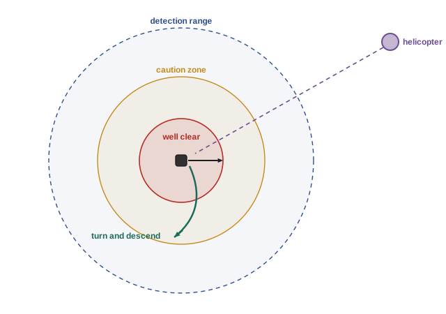
Low-altitude airspace is also becoming organized. UAS traffic management, UTM, systems let operators share flight intents, receive notices of restrictions and deconflict routes strategically before take-off, and Remote ID broadcasts each drone's identity and position so authorities and others can see it. Strategic deconfliction reduces the burden on tactical DAA but does not replace it, because crewed aircraft may not participate.
Ground risk
The other half of BVLOS safety is ground risk: the chance that a failure injures someone below. It depends on population density under the route, the drone's mass and impact energy, and its failure rate. Mitigations include routing over sparsely populated areas, parachutes that reduce impact energy, flight termination systems, and reliability engineering with redundant propulsion, power and navigation. Risk assessment methods such as the Specific Operations Risk Assessment, SORA, developed by the international JARUS group and used in many jurisdictions including Canada's risk framework, combine ground and air risk classes into a required level of robustness.
Worked problem
Ground impact energy
A 2 kg drone fails at 120 m altitude. Ignoring drag, what is its impact kinetic energy? With a parachute giving 5 m/s descent, what is it then?
Show solution
- Free fall: \( E = mgh = 2 \times 9.81 \times 120 \approx 2350 \) J.
- In reality drag limits the speed to a terminal velocity of perhaps 25 m/s: \( \tfrac{1}{2} \times 2 \times 25^2 = 625 \) J.
- Under a parachute: \( \tfrac{1}{2} \times 2 \times 5^2 = 25 \) J.
Answer: Hundreds to thousands of joules without a parachute, compared with about 25 J under one, a large reduction in injury risk that regulators credit in risk assessments.
Delivery
Drone delivery has moved from trials to routine service in some places. Operators fly small parcels, meals, prescriptions and medical supplies, often from a central hub or a store, with drones that lower packages on a tether or drop them by parachute so the aircraft stays high above people. Fixed-wing and hybrid vertical-take-off designs extend range for medical delivery in remote areas, and remote and northern communities in Canada are a natural market, because roads may be seasonal and distances large. The challenges are weather (wind, rain, icing and cold), noise acceptance, delivery site safety, airspace integration, and economics: a delivery drone must complete many trips per day with few people supervising many aircraft, which drives the push toward one-to-many operations and regulatory approval for them.
Worked problem
Delivery range check
A delivery drone cruises at 20 m/s using 400 W, hovers to lower a package for 60 s at 600 W, and has 250 Wh usable after reserve. What is the maximum one-way distance to a customer?
Show solution
- Hover energy: \( 600 \times 60 / 3600 = 10 \) Wh.
- Energy left for cruise: 240 Wh.
- Cruise power per meter: \( 400 / 20 = 20 \) J/m; 240 Wh is 864 kJ, so \( 864\,000/20 = 43\,200 \) m round trip.
- One way: about 21.6 km in still air; headwinds and cold reduce it.
Answer: About 21 km one way in still air, which operators derate substantially for wind, temperature and reserves.
Inspection
Inspection is the other big application: power lines, wind turbines, bridges, pipelines, rail, telecom towers, solar farms, roofs and mine stopes. Drones replace rope access, helicopters and scaffolding, reducing risk to workers. Autonomy helps in several ways: flying precise repeatable paths so images from successive inspections can be compared, holding a fixed standoff from structures using lidar or stereo cameras, navigating inside GNSS-denied spaces such as boiler interiors or culverts, and using on-board or cloud machine learning to flag defects such as corrosion, cracks or damaged insulators. Docking stations, drone-in-a-box systems that charge and shelter the aircraft, allow scheduled remote inspection without a crew on site, which is an important use case for BVLOS approvals. Results feed asset management systems, and human experts still review flagged findings.
Common mistakes
MistakeAssuming GNSS is always available near structures.
InsteadSteel, bridges and indoor spaces deny or disturb GNSS and compass; use visual or lidar navigation.
MistakeTreating BVLOS as a pilot skill problem only.
InsteadBVLOS replaces human see-and-avoid and needs DAA, ground-risk mitigation and approval.
MistakeRelying only on cooperative surveillance.
InsteadMany aircraft do not broadcast; non-cooperative detection is needed for full coverage.
MistakeQuoting Part 108 as current law.
InsteadAt the time of writing it is under review and not in force; check current rules.
MistakeIgnoring weather in delivery range planning.
InsteadHeadwinds, cold and icing reduce range and can ground flights.
Summary and key terms
- Autonomous missions use planned waypoints, on-board obstacle avoidance and contingency landing sites.
- GNSS-denied navigation uses visual-inertial odometry or lidar SLAM.
- BVLOS operations replace the pilot's see-and-avoid with DAA and ground-risk mitigation.
- Canada has allowed lower-risk BVLOS since November 2025; US Part 108 is proposed but not in force at the time of writing.
- DAA needs detection range matched to closing speed and the time budget to maneuver.
- UTM and Remote ID organize low-altitude airspace strategically.
- Delivery and inspection are the leading commercial applications, each with distinct autonomy needs.
- VLOS
- Visual line of sight: the pilot can see the drone unaided.
- BVLOS
- Beyond visual line of sight operation.
- Detect and avoid
- Capability to detect traffic and maneuver to remain well clear.
- Cooperative surveillance
- Detecting aircraft from signals they broadcast, such as ADS-B.
- Non-cooperative surveillance
- Detecting aircraft with radar, cameras or acoustics without their participation.
- UTM
- UAS traffic management, services for sharing and deconflicting drone flights.
- Remote ID
- Broadcast of a drone's identity and location in flight.
- SORA
- Specific Operations Risk Assessment, a structured method for drone operational risk.
- Ground risk
- The risk that a drone failure harms people or property on the ground.
- Drone-in-a-box
- A docking station that shelters and charges a drone for remote operations.
Practice problems
Work each problem on paper first, then reveal the answer to check.
Camera footprint 80 m, side overlap 75 %: line spacing?
Show answer
20 m.
Why is BVLOS valuable commercially?
Show answer
Delivery, long linear inspection and large-area work need it.
Name a cooperative and a non-cooperative DAA sensor.
Show answer
ADS-B receiver; radar or camera.
Closing 70 m/s with a 16 s time budget and 600 m separation: detection range?
Show answer
1,720 m.
What does a parachute do for ground risk?
Show answer
Reduces impact energy.
Name two regions where delivery drones are especially useful in Canada.
Show answer
Remote and northern communities, or sites with seasonal roads.
What is a drone-in-a-box?
Show answer
A docking station that charges and shelters a drone for remote missions.
Why fly repeatable inspection paths?
Show answer
To compare images over time and detect change.
What altitude limit applies to Canadian lower-risk BVLOS?
Show answer
Below 122 m (400 ft).
Where should students look for detailed drone regulations?
Show answer
PHOT-350 and current regulator guidance.
Lesson quiz · 5 questions
Score 60% or more to complete this lesson.
Create a free account to save your progress, take quizzes and earn a certificate.