
CON-250 · Lesson 2 of 12 · 34 min
Distances and leveling
The two measurements that construction depends on most are horizontal distance and difference in height. Distances locate walls, footings and property offsets. Height differences set footing bottoms, floor slabs, pipe inverts and finished grades. This lesson covers how distances are measured with tapes and electronic instruments, and how heights are carried across a site by leveling, the oldest and still the most precise way to transfer elevations.
Measuring distance with a tape
Steel tapes, typically 100 or 200 feet long, are still used for short layout distances, checking forms and measuring building diagonals. Fiberglass tapes are fine for rough work but stretch too much for precise layout. A steel tape is standardized at a stated temperature and tension, usually 68 °F and a pull of around 10 to 20 pounds, and gives its nominal length only under those conditions.
When conditions differ, systematic errors appear. The main corrections are listed below. On most construction sites the temperature correction is the one that matters, because a steel tape left in the summer sun can be 30 degrees warmer than its standard.
- Temperature: steel expands about 0.0000116 of its length for each degree Celsius. A 30 m tape at 40 °C is about 7 mm longer than at 20 °C, so it reads short.
- Tension: pulling harder than the standard tension stretches the tape; pulling less shortens it.
- Sag: a tape supported only at its ends hangs in a curve, so the straight-line distance is shorter than the tape reading. Supporting the tape on the ground or applying the correct tension removes most of this error.
- Slope: a tape held along a slope measures slope distance, not horizontal distance. Either hold the tape level and use a plumb bob, or measure the slope or height difference and correct.
- Standardization: a tape that has been kinked and spliced, or simply worn, may not be its nominal length. Compare it with a calibrated tape or a baseline.
Horizontal distance from a slope measurement uses Pythagoras when the height difference is known, or the cosine of the slope angle when the vertical angle is known.
Worked problem
Correcting a taped distance
A distance is taped as 94.00 ft along a slope with a height difference of 4.60 ft. The tape is at 95 °F (standard 68 °F). What is the corrected horizontal distance?
Show solution
- Temperature correction: 0.00000645 per °F × 94.00 × (95 − 68) = +0.016 ft. The warm tape is long, so the true slope distance is 94.016 ft.
- Horizontal distance: √(94.016² − 4.60²) = √(8,839.01 − 21.16) = √8,817.85 = 93.90 ft.
- The slope correction (about 0.11 ft) is much larger than the temperature correction.
Answer: About 93.90 ft horizontal.
Electronic distance measurement
Almost all longer distances on a construction site are now measured electronically, by a total station or by GNSS. An electronic distance measurement (EDM) unit sends a modulated infrared or laser beam to a reflector, usually a glass prism, and measures the phase shift or travel time of the returned signal. Modern instruments measure to a prism at a few hundred meters with an accuracy of about 1 to 2 millimeters plus 1 to 2 parts per million of the distance. Many also measure reflectorless, bouncing the beam off a wall or surface, which is convenient for as-built checks but less reliable at long range or on dark, wet or angled surfaces.
EDM is subject to its own systematic errors. The prism constant, the offset between the optical center of the prism and the point being measured, must be set correctly in the instrument; mixing prisms with different constants is a classic cause of consistent errors of 30 millimeters or more. Air temperature and pressure change the speed of light slightly, so the instrument applies an atmospheric correction, which needs the correct temperature and pressure entered. The instrument measures slope distance and uses the vertical angle to reduce it to horizontal distance and height difference.
| Method | Typical use on site | Typical accuracy |
|---|---|---|
| Steel tape, 100 ft | Short layout, diagonals, form checks | 0.01 ft per tape length if corrected |
| Handheld laser distance meter | Interior measurements, quick checks | About 1/16 to 1/8 in over short distances |
| Total station EDM to prism | Control, layout, as-builts | 0.005 ft + 2 ppm |
| Total station reflectorless | Inaccessible points, facades | About 0.01 ft at short range |
| RTK GNSS | Site control, grading, utilities | 0.03 to 0.06 ft horizontal, 0.06 to 0.10 ft vertical |
Leveling: the principle
Leveling determines differences in height by reading a graduated staff, or rod, through an instrument whose line of sight is horizontal. If the instrument reads 1.520 on a rod held on a benchmark and 2.840 on a rod held on a second point, the second point is 1.320 lower, because the rod had to extend further down to reach it. The instrument's own height above the ground does not matter; only the readings do.
Surveyors use three terms. A backsight (BS) is a reading on a point of known elevation, taken to establish the height of the instrument. The height of instrument (HI) is the elevation of the line of sight. A foresight (FS) is a reading on a point whose elevation is wanted. Intermediate sights (IS) are extra foresights taken from the same setup, for example along a profile, that are not used to carry the elevation forward.
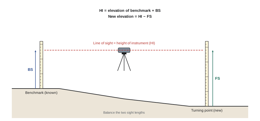
When the next point is too far away or too high or low to read from one setup, the level is moved. The last point read from the first setup becomes a turning point (TP): it receives a foresight from the first setup and a backsight from the second. The turning point must be stable, such as a steel pin, a solid rock or a nail in a curb, because the rod is turned on it while the instrument moves.
The level book
Leveling notes are kept in a standard table. The arithmetic check is that the sum of backsights minus the sum of foresights equals the last elevation minus the first. This catches arithmetic mistakes, though not reading mistakes.
| Station | BS | HI | FS | Elevation |
|---|---|---|---|---|
| BM 1 | 4.52 | 104.52 | 100.00 | |
| TP 1 | 2.87 | 99.89 | 7.50 | 97.02 |
| TP 2 | 6.71 | 102.54 | 4.06 | 95.83 |
| TBM A | 2.09 | 100.45 | ||
| Sums | 14.10 | 13.65 | Check: 14.10 − 13.65 = 0.45 = 100.45 − 100.00 |
Worked problem
Reducing a level run
From BM 1 (elevation 100.00 ft) the readings are: BS 4.52 on BM 1; FS 7.50 on TP 1; BS 2.87 on TP 1; FS 4.06 on TP 2; BS 6.71 on TP 2; FS 2.09 on TBM A. Find the elevation of TBM A.
Show solution
- HI 1 = 100.00 + 4.52 = 104.52; TP 1 = 104.52 − 7.50 = 97.02.
- HI 2 = 97.02 + 2.87 = 99.89; TP 2 = 99.89 − 4.06 = 95.83.
- HI 3 = 95.83 + 6.71 = 102.54; TBM A = 102.54 − 2.09 = 100.45.
- Check: ΣBS − ΣFS = 14.10 − 13.65 = 0.45 = 100.45 − 100.00.
Answer: TBM A is at 100.45 ft.
Closing the loop and allowable misclosure
A level run is only proven when it closes: either back on the starting benchmark (a loop) or on a second benchmark of known elevation. The difference between the computed and known closing elevation is the misclosure. If it is within the allowable value, it is distributed through the run; if not, the run is repeated.
Allowable misclosure is usually written as a constant multiplied by the square root of the distance leveled, because random errors grow with the square root of the number of setups. A common construction value is about 0.02 to 0.05 ft × √M, where M is the distance in miles, while the NGS standards for precise control leveling are far tighter.
A misclosure that passes is distributed in proportion to the distance from the start, or equally per setup when setups are similar. A turning point halfway around the loop receives half the correction.
Worked problem
Checking and adjusting a loop
A level loop of 1.0 mile returns to BM 1 (100.00 ft) with a computed closing elevation of 100.03 ft. The specification allows 0.04 ft × √M. TBM A lies 0.25 mile along the loop. Does the loop pass, and what is the adjusted elevation of TBM A if it was computed as 100.45 ft?
Show solution
- Misclosure = 100.03 − 100.00 = +0.03 ft.
- Allowable = 0.04 × √1.0 = 0.04 ft. The loop passes.
- Correction at TBM A = −0.03 × (0.25 ÷ 1.0) ≈ −0.008 ft, which rounds to −0.01 ft.
- Adjusted TBM A = 100.45 − 0.01 = 100.44 ft.
Answer: The loop passes (0.03 ft against 0.04 ft allowed); TBM A adjusts to about 100.44 ft.
Systematic errors in leveling and how procedure removes them
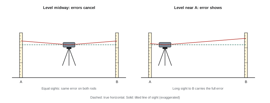
The most important systematic error in leveling is collimation error: the line of sight of the instrument is not exactly horizontal when the bubble or compensator says it is, but tilts up or down by a small angle. The error in each reading is proportional to the sight length. If the backsight and foresight from a setup are the same length, the two errors are equal and cancel when the foresight is subtracted from the backsight. This is why surveyors pace or measure their sight lengths and balance them.
Balanced sights also cancel most of the curvature and refraction effect described in Lesson 1. Short sights, typically no longer than 50 to 70 meters for construction work and much shorter for precise leveling, reduce the effect of heat shimmer and reading errors.
The two-peg test checks collimation. Two pegs are set about 50 to 60 meters apart. The level is set exactly halfway between them and the true height difference is measured, because the errors cancel. The level is then moved close to one peg and the readings are repeated. If the height difference changes, the line of sight is tilted, and the instrument needs adjustment. Many specifications require a two-peg test at the start of a project and at regular intervals.
Worked problem
Two-peg test
With the level midway, readings are A = 4.70 and B = 4.00, so B is 0.70 ft higher. With the level next to A, readings are A = 4.94 and B = 4.18. Is there a collimation error, and how large over the 200 ft sight?
Show solution
- From the second setup, B appears 4.94 − 4.18 = 0.76 ft higher.
- True difference is 0.70 ft, so the error is 0.06 ft over the 200 ft sight to B.
- That is 0.03 ft per 100 ft, far more than acceptable. The level must be adjusted.
Answer: Yes: about 0.06 ft over 200 ft; send the level for adjustment.
Other errors to control include a rod that is not held plumb (a rod level or a gentle rocking motion, taking the smallest reading, solves this), a rod sinking into soft ground at a turning point, the instrument settling on soft ground or asphalt in the sun, misreading the rod by a whole decimeter or foot, and reading the wrong stadia hair instead of the center crosshair.
Levels and lasers on a construction site
Construction sites use several kinds of leveling instruments.
- Automatic levels have a pendulum compensator that keeps the line of sight horizontal once the instrument is roughly leveled. They are robust and accurate to about 1 to 2 millimeters per kilometer of double-run leveling.
- Digital levels read a bar-coded staff electronically, removing reading blunders and recording the data automatically. They are used for precise control and settlement monitoring.
- Rotating lasers spin a horizontal (or sloped) laser plane across the site. A detector on a rod or on a machine beeps or shows arrows when it is on the plane. One person can then check footing excavations, set forms or grade a pad without a second person reading the rod.
- Line and point lasers project plumb, level and square lines for interior layout of walls, ceilings and fixtures.
With a rotating laser, the logic is the same as with a level. The laser plane is the HI. Set the detector at a known reading on a benchmark, and then the cut or fill at any point is the difference between the reading needed for the design grade and the reading where the detector finds the beam. Many contractors use grade rods with an adjustable tape so the detector reads zero at the design grade, turning the rod into a direct cut or fill gauge.
Worked problem
Cut and fill with a rotating laser
A laser is set up; the rod reads 4.75 ft on TBM A (elevation 100.45 ft). The design subgrade for a footing is 94.90 ft. At one point the rod reads 10.10 ft. Should the excavator dig deeper or fill?
Show solution
- HI of laser plane = 100.45 + 4.75 = 105.20 ft.
- Rod reading needed at design subgrade = 105.20 − 94.90 = 10.30 ft.
- Actual reading 10.10 ft is 0.20 ft less, so the ground is 0.20 ft too high.
- The excavator must cut a further 0.20 ft, about 2-3/8 inches.
Answer: Cut about 0.20 ft more.
Profile leveling and trigonometric heights
Profile leveling measures ground elevations at regular stations along a line, such as the centerline of a road or a pipe trench, so that the existing ground can be drawn and compared with the design grade. The level is set up, a backsight is taken on a benchmark or turning point, and intermediate sights are taken at each station and at every break in the ground. Profiles and cross-sections built this way are the raw material for the earthwork calculations in Lesson 8.
Trigonometric leveling uses a total station to measure slope distance and vertical angle, and computes the height difference. It is fast and works over rough ground, and it is how a total station computes elevations during layout. Its accuracy depends on measuring the instrument height and target height correctly; a wrong prism pole height is a common source of elevation blunders.
Here S is the slope distance, α is the vertical angle above horizontal, hᵢ is the height of the instrument above its station and hₜ is the height of the target above the point.
Common mistakes
MistakeTaking long, unbalanced backsights and foresights.
InsteadBalance sight lengths from each setup so collimation and curvature errors cancel, and keep sights short.
MistakeUsing a turning point on soft soil or a loose stone.
InsteadUse a stable turning point such as a steel pin or a solid structure, and avoid moving the rod while the instrument moves.
MistakeAccepting a level run that was never closed.
InsteadEvery run must close on a known benchmark, and the misclosure must be within the allowable value.
MistakeSkipping the two-peg test because the level is new.
InsteadLevels go out of adjustment in transport and use; test at the start and at intervals.
MistakeForgetting to change the prism pole height in the data collector.
InsteadEvery change of target height must be recorded, or every elevation is wrong by the difference.
MistakeHolding the rod tilted.
InsteadUse a rod level; a tilted rod always reads too high.
Summary and key terms
- Steel tapes need corrections for temperature, tension, sag, slope and standardization; slope is usually the largest.
- EDM measures to prisms or surfaces; the prism constant and atmospheric correction must be set correctly.
- In leveling, HI = known elevation + BS and new elevation = HI − FS.
- ΣBS − ΣFS must equal the change in elevation from start to finish.
- Every level run must close; allowable misclosure is a constant times the square root of the distance.
- Balanced sights cancel collimation and curvature errors; the two-peg test checks collimation.
- Rotating lasers make the laser plane the HI, so cut and fill can be read directly from a grade rod.
- EDM
- Electronic distance measurement using a modulated light beam.
- Prism constant
- The offset between a prism's optical center and its plumb point, set in the instrument.
- Backsight
- A rod reading on a point of known elevation.
- Foresight
- A rod reading on a point whose elevation is to be determined.
- Height of instrument
- The elevation of the instrument's line of sight.
- Turning point
- A stable point used to carry elevation from one setup to the next.
- Misclosure
- The difference between the computed and known elevation at the end of a level run.
- Collimation error
- The tilt of a level's line of sight away from horizontal.
- Two-peg test
- A field test that measures collimation error.
- Rotating laser
- An instrument that sweeps a laser plane across a site for leveling and grading.
Practice problems
Work each problem on paper first, then reveal the answer to check.
A 100 ft tape is used at 40 °F (standard 68 °F). Does it read long or short, and by how much over 100 ft?
Show answer
The cold tape is short by 0.00000645 × 100 × 28 ≈ 0.018 ft, so it reads long; subtract about 0.02 ft from each full length.
A slope distance of 150.00 ft has a height difference of 10.00 ft. What is the horizontal distance?
Show answer
√(150² − 10²) = √22,400 = 149.67 ft.
BS on BM (elevation 287.25 ft) is 4.36. What is the HI? The FS on a slab is 2.97. What is the slab elevation?
Show answer
HI = 291.61 ft; slab = 288.64 ft.
A 1.5 mile loop has a misclosure of 0.06 ft. The allowable is 0.04 ft × √M. Does it pass?
Show answer
Allowable = 0.04 × 1.22 = 0.049 ft; 0.06 ft fails, so rerun the loop.
Why are backsight and foresight lengths balanced?
Show answer
So that collimation error and curvature and refraction are equal in both readings and cancel.
What does a two-peg test detect?
Show answer
Collimation error: a line of sight that is not horizontal when the instrument is level.
A laser plane HI is 167.00 ft. Design top of footing is 161.75 ft. What rod reading marks the design?
Show answer
167.00 − 161.75 = 5.25 ft.
Name two sources of error when reading a rod.
Show answer
Rod not plumb, misreading by a whole decimeter or foot, rod settling, reading a stadia hair, heat shimmer.
Lesson quiz · 5 questions
Score 60% or more to complete this lesson.
Create a free account to save your progress, take quizzes and earn a certificate.