
CON-110 · Lesson 2 of 12 · 25 min
Site preparation: surveys, clearing, utilities and demolition handoff
Before the first footing is formed, a construction site must be prepared. Site preparation turns an empty lot, a field or a site with existing buildings into a safe, organized working area with access, controls, temporary services and a clear starting surface. It includes surveying and layout control, protecting what must be kept, locating and dealing with existing utilities, clearing and grubbing, stripping topsoil, removing or receiving the site from demolition, controlling erosion and sediment, and setting up access roads, laydown areas and temporary drainage. Mistakes at this stage, such as hitting a gas line, damaging a neighbor's foundation or releasing muddy water into a stream, can be dangerous, expensive and damaging to relationships. This lesson covers the sequence and methods of site preparation and the coordination it requires.
Pre-construction surveys and documentation
Site preparation begins with information and records. Typical steps include:
- A legal survey confirming property boundaries, easements and encroachments, so that work stays on the property and respects rights of way.
- A topographic survey showing existing ground levels, buildings, trees, utilities and features, used for design and for calculating earthwork quantities.
- Establishing survey control: benchmarks for elevation and control points for horizontal position, protected so they survive construction.
- A pre-construction condition survey of neighboring buildings, roads and structures, with photographs and notes of existing cracks and damage. This protects everyone if claims of damage from vibration or excavation arise later.
- Vibration and settlement monitoring plans where excavation, piling or compaction is close to sensitive structures.
- Records of existing trees, heritage features and environmental elements to be protected.
CON-250 covers surveying and layout in depth.
Locating existing utilities
Underground utilities, including gas, electricity, telecommunications, water, sewer and district energy lines, are a serious hazard and a frequent cause of delays. Striking a gas line can cause explosions; striking a power cable can electrocute workers; damaging a fiber trunk line can disrupt communications for thousands of people. Before any ground disturbance, the contractor must request utility locates.
In the United States, the national 811 number connects excavators to the state one-call center, and state laws require notification a set number of working days before digging, commonly two or three. Member utilities then mark their lines using the APWA color code. Locates cover facilities owned by members; private lines on the property, such as lines to outbuildings or parking lot lighting, often require a private locator.
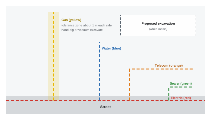
Marks are made with paint, flags or stakes using a standard color code: red for electrical, yellow for gas and oil, orange for communications, blue for potable water, green for sewer and drainage, purple for reclaimed water, white for proposed excavation and pink for temporary survey marks. Locates show approximate positions, typically within a tolerance zone of about 1 m (3 ft) on either side of the marked line, so excavation inside that zone must be done with hand tools or hydro-vacuum excavation until the utility is exposed. Locates expire after a set period and must be renewed. Utilities that must be relocated, disconnected or protected require coordination with the owning utility, often with long lead times that affect the schedule.
Protecting what must be kept
Many sites include trees, landscaping, adjacent structures, heritage elements or sensitive areas that must be protected. Tree protection zones, typically defined by the drip line or a distance set by an arborist or municipal by-law, are fenced off to prevent compaction, root damage and storage of materials. Neighboring structures may need underpinning or monitoring when excavation goes deeper than their foundations. Public sidewalks and roads may need protection or temporary closures with permits. Protecting these features is far cheaper than repairing or replacing them, and municipal permits often include fines for damaging protected trees.
Clearing, grubbing and stripping
Clearing removes trees, brush, fences, debris and surface obstructions. Grubbing removes stumps and roots below the surface. Stripping removes the topsoil, the dark, organic upper layer, which is unsuitable for supporting structures or pavements because it is compressible and decays. Topsoil is usually stockpiled on site for reuse in landscaping, protected from erosion with covers or vegetation, or hauled away if surplus. Stripping depths vary, typically 100 to 300 mm (4 to 12 in), and should be confirmed by the geotechnical engineer in the field, since organic layers may be deeper in low areas. Stripped areas are then proof-rolled, driven over with a loaded truck or heavy roller to reveal soft spots that deflect or pump, which are excavated and replaced.
Worked problem
Estimating topsoil stripping
A site has a building footprint plus paved areas totaling 6,500 m² (about 70,000 ft²) to be stripped to an average depth of 200 mm (8 in). If 2,000 m³ of topsoil can be reused in landscaping, how much must be hauled away, measured in place (bank volume)?
Show solution
- Stripped volume: 6,500 m² × 0.20 m = 1,300 m³ (in imperial, about 70,000 ft² × 0.667 ft ≈ 46,700 ft³, or about 1,730 yd³).
- Landscaping can reuse up to 2,000 m³, more than the 1,300 m³ available.
- No topsoil needs to be hauled away; in fact, about 700 m³ more may need to be imported for landscaping.
- Remember that loose volumes for trucking and stockpiles will be larger than bank volumes (Lesson 3).
Answer: About 1,300 m³ will be stripped; it can all be reused, and about 700 m³ of additional topsoil may need to be imported.
Demolition and the handoff to new construction
Many projects begin with existing buildings that must be demolished. Demolition is often a separate contract and has its own hazards and regulations, including surveys for asbestos, lead, polychlorinated biphenyls (PCBs), mold and other hazardous materials, which must be removed before demolition; utility disconnections; protection of neighboring properties; and dust, noise and vibration control. HSE-372 covers demolition safety. For the general contractor and construction manager, the key issue is the handoff: what condition the site will be in when new construction begins. Questions to settle include whether old foundations, basements and slabs will be removed entirely or left in place; whether voids will be backfilled and compacted to a specified standard; whether underground tanks, pipes and utilities have been removed or abandoned properly; whether hazardous materials have been cleared and documented; and who is responsible for any contamination found later. Unclear handoffs are a common source of disputes, so contracts should define the expected condition, and the receiving contractor should inspect and document the site before accepting it.
Erosion and sediment control
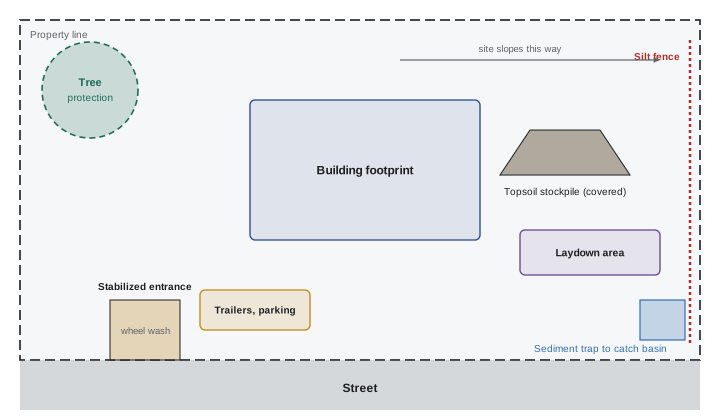
Stripped soil exposed to rain and snowmelt erodes, carrying sediment into storm sewers, streams and neighboring properties. Sediment damages aquatic habitat, blocks drainage and can lead to fines and stop-work orders. Erosion and sediment control (ESC) plans, often required by municipalities and environmental regulators, specify measures such as:
- Phasing work to minimize the area exposed at any time.
- Silt fences along the downslope perimeter.
- Sediment traps and ponds to let water settle before discharge.
- Catch basin protection.
- Mud mats or stabilized construction entrances, often of crushed stone, and wheel washes to keep mud off public roads.
- Temporary seeding, mulching and erosion blankets on stockpiles and slopes.
- Check dams in ditches and swales.
ESC measures must be inspected regularly, especially after storms, and maintained throughout construction until permanent landscaping is established.
In the United States, construction sites disturbing one acre or more generally need coverage under a National Pollutant Discharge Elimination System (NPDES) construction stormwater permit under the Clean Water Act, issued by the EPA or the state, with a stormwater pollution prevention plan (SWPPP) and regular inspections. State and local rules often add requirements.
Access, laydown and temporary facilities
A prepared site needs safe access for workers, deliveries and emergency vehicles, separated where possible from public pedestrians and traffic. Construction roads are built of compacted granular material, sometimes the same material that will later form the base for permanent pavement. Laydown areas for materials, parking, site offices, washrooms, first aid stations and storage are located where they will not block later work. Temporary drainage keeps the site workable. Temporary power, water and lighting are arranged with utilities. Hoarding or fencing secures the perimeter, protects the public and displays required signage. CON-325 covers site logistics planning in depth, but a good logistics plan begins during site preparation.
Sequencing site preparation
A typical sequence is: obtain permits and approvals; complete pre-construction surveys and condition surveys; install perimeter fencing and erosion controls first, before disturbing soil; request utility locates and arrange disconnections or relocations; protect trees and features to be kept; complete demolition and abatement if required; clear and grub; strip and stockpile topsoil; proof-roll and repair soft areas; build access roads and laydown areas; set up temporary facilities and services; and establish layout control for the building. Each step depends on the previous ones, and delays in permits, utility work or demolition often delay everything that follows, so these early activities deserve close attention in the schedule (CON-210).
Coordinating site preparation activities
Site preparation involves many trades and outside parties in a short time, and the order in which activities happen matters. A typical sequence on a greenfield commercial site starts with the survey control and the condition survey of neighboring property, followed by utility locates, installation of tree protection fencing and erosion and sediment controls, construction of the site entrance with a mud mat or wheel wash, clearing and grubbing, topsoil stripping and stockpiling, and finally proof-rolling and the start of mass earthwork. On urban sites, the sequence may begin with hoarding, pedestrian protection, traffic management permits and the disconnection of existing services before the demolition contractor finishes and hands the site over.
Each of these steps has its own approvals. Erosion and sediment controls often need to be inspected by the municipality or the environmental authority before any soil is disturbed, and some jurisdictions restrict clearing during bird nesting seasons, which can push tree removal to the autumn or winter. Road occupancy permits may limit when trucks can enter and leave the site, and noise bylaws restrict working hours. A short look-ahead schedule that lists each activity, the permit or inspection it needs, the responsible party and the date is a simple way to keep site preparation from stalling.
Records and handoff
Before mass earthwork begins, the site team should assemble a set of records that will be useful for the rest of the project: the pre-construction condition survey with photographs and video of neighboring buildings, roads and sidewalks; the utility locate tickets and any marks that were refreshed; tree protection and erosion control inspection records; the demolition contractor's closeout documents, including disposal records for hazardous materials and confirmation that services have been cut and capped; and the survey of existing grades after stripping. These records protect the contractor against later claims of damage, provide the baseline for measuring earthwork quantities, and demonstrate compliance with permits.
It is also good practice to hold a short start-up meeting with the earthwork subcontractor, the surveyor, the geotechnical engineer and the testing agency. The meeting confirms how stripping depths will be checked, where topsoil will be stockpiled, who will call for proof-roll observations, how unsuitable soils will be identified and measured for payment, and how test results will be communicated. Clear agreements at the start avoid disputes about quantities and quality later in the job, when earthwork is buried and can no longer be measured.
Common mistakes
MistakeExcavating without current utility locates.
InsteadRequest locates, respect the tolerance zone and hand dig or vacuum excavate.
MistakeSkipping the pre-construction condition survey of neighbors.
InsteadDocument existing conditions with photos and notes.
MistakeAccepting a demolished site without inspection.
InsteadDefine the handoff condition and inspect before accepting.
MistakeInstalling silt fences after stripping.
InsteadInstall erosion controls before disturbing soil.
MistakeStoring materials inside tree protection zones.
InsteadFence protected areas and keep them clear.
Summary and key terms
- Site preparation creates a safe, organized and documented starting point.
- Legal, topographic and condition surveys protect the project and neighbors.
- Utility locates and hand digging within the tolerance zone prevent strikes.
- Clearing, grubbing and stripping remove vegetation and topsoil before proof-rolling.
- Demolition handoff conditions must be defined and inspected.
- Erosion and sediment controls are installed first and maintained.
- Access, laydown and temporary services set up the logistics of the project.
- Benchmark
- Point of known elevation for survey control.
- Condition survey
- Record of existing condition of neighboring property.
- Locate
- Marking of buried utilities by their owners.
- Tolerance zone
- Area either side of a marked utility requiring careful digging.
- Hydro-vacuum excavation
- Digging with pressurized water and suction.
- Clearing and grubbing
- Removing vegetation, stumps and roots.
- Stripping
- Removing topsoil.
- Proof-rolling
- Driving heavy equipment over subgrade to find soft spots.
- Silt fence
- Fabric barrier that traps sediment.
- Stabilized construction entrance
- Stone pad that removes mud from vehicles.
Practice problems
Work each problem on paper first, then reveal the answer to check.
Why survey neighboring buildings before work?
Show answer
To document existing conditions in case of damage claims.
What color marks gas lines?
Show answer
Yellow.
What color marks proposed excavation?
Show answer
White.
How must you dig within the tolerance zone?
Show answer
By hand or with hydro-vacuum excavation.
Why is topsoil removed under structures?
Show answer
It is organic and compressible.
What does proof-rolling reveal?
Show answer
Soft or pumping areas.
Volume of 4,000 m² stripped 250 mm deep?
Show answer
1,000 m³.
Name two demolition handoff questions.
Show answer
Old foundations, backfill standard, tanks and utilities, hazardous materials.
Name three erosion control measures.
Show answer
Silt fence, sediment trap, catch basin protection, mud mat, seeding.
What should be installed first on a site?
Show answer
Perimeter fencing and erosion controls.
Lesson quiz · 5 questions
Score 60% or more to complete this lesson.
Create a free account to save your progress, take quizzes and earn a certificate.