
CIV-499 · Lesson 8 of 12 · 19 min
The path, parking and accessibility
A bridge that people cannot comfortably reach has failed, however good its trusses are. The trail link exists so that walkers, cyclists, people using wheelchairs and walkers, parents with strollers and older residents can get from Ridgeway Road to the pavilion without walking on the road shoulder. This lesson designs the approach paths and their profiles, checks sight distance for cyclists, lays out the trailhead parking with accessible stalls, and designs the crossing of Ridgeway Road. It also looks at accessibility as something to check with the people it serves, not only against a standard.
Accessibility standards
In the United States, the Americans with Disabilities Act applies to the city's facilities. The 2010 ADA Standards cover parking, accessible routes on the site and ramps. For pedestrian facilities in the public right-of-way, the Access Board issued its final Public Right-of-Way Accessibility Guidelines in 2023; they become enforceable standards only as federal agencies adopt them, and the Department of Transportation adopted them for transit stops in a rule that took effect in January 2025. Many agencies, including the city, already apply them as good practice for sidewalks and crossings. Shared use paths have no final federal standard, so the city's trail guidelines draw on these documents and on the outdoor developed area guidelines for trails. The team designs to the strictest applicable requirement and records the source.
For the trail link, the practical requirements reduce to a short list: a firm, stable and slip-resistant surface; a clear width well above the minimum; running grades of 5 % or less, so that the approaches are not ramps and need no handrails or intermediate landings; cross slopes of 2 % or less; level rest areas at intervals on longer grades; edge protection where the path runs above a drop; and accessible parking with a level route to the path. A trail that meets these conditions is usable by a far wider range of people than one that meets only the minimums.
Approach profiles
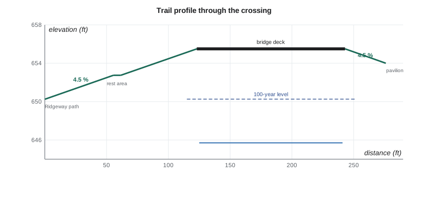
The deck sits at 655.50 ft at both abutments, set by the low chord in lesson 3 plus the depth of the floor system. The Ridgeway Road path at the south end of the approach is at 650.25 ft, and the pavilion path at the north end is at 654.00 ft. The south approach therefore has to climb 5.25 ft, and the north approach only 1.50 ft.
# Approach profiles, bicycle stopping sight distance and accessible parking for the trail link
import math
UNITS = "US"
SI = UNITS == "SI"
if SI:
    deck = 199.80                                 # top of deck at the abutments (m)
    ends = {"south approach (Ridgeway Road)": 198.20, "north approach (pavilion)": 199.35}
    V, t, f = 30.0, 2.5, 0.16                     # km/h, reaction time s, wet friction for bicycles
    ssd = lambda G: V * t / 3.6 + V ** 2 / (254 * (f + G))
    u = "m"
else:
    deck = 655.50                                 # ft
    ends = {"south approach (Ridgeway Road)": 650.25, "north approach (pavilion)": 654.00}
    V, t, f = 20.0, 2.5, 0.16                     # mph
    ssd = lambda G: 1.47 * V * t + V ** 2 / (30 * (f + G))
    u = "ft"
gmax = 0.05                                       # running grade at or under 5 % avoids ramp features
for name, z in ends.items():
    rise = deck - z
    print(f"{name:32s} rise {rise:4.2f} {u}: {rise / gmax:5.1f} {u} at 5 %, {rise / 0.045:5.1f} {u} at the 4.5 % design grade")
for G in (0.0, -0.05):
    print(f"Bicycle stopping sight distance at {V:.0f} {'km/h' if SI else 'mph'}, grade {G:+.0%}: {ssd(G):.0f} {u}")
stalls = 32
if SI:
    acc = math.ceil(0.04 * stalls)               # 4 % of 13 to 100 spaces
    typeA = acc // 2                              # split equally; an odd extra space is Type B
    print(f"\n{stalls} stalls: {acc} accessible stalls ({typeA} Type A van-accessible, {acc - typeA} Type B)")
else:
    acc = 2 if stalls <= 50 else 3                # 26 to 50 spaces -> 2
    van = max(1, math.ceil(acc / 6))
    print(f"\n{stalls} stalls: {acc} accessible stalls, at least {van} van-accessible")
bike = math.ceil(stalls * 0.25)
print(f"Bicycle parking (city criteria, 25 % of car stalls): {bike} spaces")south approach (Ridgeway Road) rise 5.25 ft: 105.0 ft at 5 %, 116.7 ft at the 4.5 % design grade north approach (pavilion) rise 1.50 ft: 30.0 ft at 5 %, 33.3 ft at the 4.5 % design grade Bicycle stopping sight distance at 20 mph, grade +0%: 157 ft Bicycle stopping sight distance at 20 mph, grade -5%: 195 ft 32 stalls: 2 accessible stalls, at least 1 van-accessible Bicycle parking (city criteria, 25 % of car stalls): 8 spaces
At 5 % the south approach would be 105 ft long. Amara designs it at 4.5 %, about 117 ft long, to leave a tolerance for construction: a path built a fraction of an inch high at one point can push a 5.0 % design grade over the limit, and fixing that in the field is expensive. A level rest area 6 ft long is placed halfway, where the trail widens beside a bench. The north approach is a short 4.5 % grade of about 33 ft. Both approaches have a 2 % cross slope for drainage, falling away from the creek.
Cyclists: width and sight distance
The path is shared by walkers and cyclists, and the most common complaints on shared paths are about speed and surprise. The design speed for the trail is 20 mph, typical for a shared path in an urban park. The clear width of 12 ft on the bridge and the approaches allows two cyclists to pass a pair of walkers, and the railings have a rub rail at handlebar height. On the approaches, the path is edged with a 2 ft graded shoulder on each side, so that a cyclist who drifts does not drop off a hard edge.
Stopping sight distance for a cyclist is the distance traveled during the perception and reaction time plus the braking distance, with a low friction coefficient for wet pavement and an allowance for grade:
with V in mph, t of 2.5 s and f of 0.16, following AASHTO's bicycle facilities guide. On the 4.5 % descent from the deck toward Ridgeway Road, the sight distance is about 195 ft. The path must give that much clear sight to the junction with the Ridgeway path, so the planting plan keeps shrubs back from the inside of the curve where the approach meets it, and the junction has a short widened area where cyclists slow before joining.
Worked problem
Sight distance on the descent
Find the stopping sight distance for a cyclist at 20 mph on a 5 % descent, with t = 2.5 s and f = 0.16.
Show solution
- \[\text{reaction} = 1.47 \times 20 \times 2.5 = 73.5\ \text{ft}\]
- \[\text{braking} = \frac{20^2}{30\,(0.16 - 0.05)} = 121\ \text{ft}\]
- \[SSD = 73.5 + 121 = 195\ \text{ft}\]
Answer: The descent adds about a quarter to the level-ground distance, so sight lines matter most at the bottom of the approach.
Trailhead parking
The lot has 32 stalls, as agreed with the client after a short parking study that compared weekend demand at two similar trailheads in the city. Under the ADA Standards, a lot of 26 to 50 spaces needs two accessible spaces, and at least one in six accessible spaces must be van-accessible, so the lot has one van-accessible space with a wide access aisle and one standard accessible space. Both are next to the plaza, with a level route to the path, and are signed as the standards require.
The lot also has eight bicycle parking spaces, a quarter of the car stalls under the city's guideline, placed under the view of the plaza for security. The drive aisle is designed for the parks maintenance vehicle and a small fire truck to turn, and the lot's grading sends all runoff to the bioretention cell from lesson 7. The bollards at the path entrance keep cars off the trail but leave a clear gap wide enough for wheelchairs and for the maintenance vehicle when one bollard is removed.
Crossing Ridgeway Road
Many users will arrive from the residential streets on the south side of Ridgeway Road, which the corridor study rebuilt as a two-lane road with a center turn lane, still posted at 35 mph. The team proposes a marked crosswalk at the trail connection with rectangular rapid-flashing beacons activated by push buttons, a median refuge in the turn lane, and curb ramps with detectable warning surfaces. Rectangular rapid-flashing beacons are now covered by the current edition of the MUTCD. The roads engineer reviews the proposal against the corridor study's volumes and agrees that it is appropriate at this location.
The crossing also gets a small drop-off area on the trailhead side, so that parents and accessible transit vehicles can stop briefly without entering the lot, and the corridor's bus stop, a short walk to the west, is linked to the crossing by the rebuilt sidewalk. Lucas checks the walking time from the stop to the bridge at a slow walking speed of 3 ft/s, about four minutes, and the team notes it on the map board.
Surfaces, winter and wayfinding
The approach paths are asphalt on a granular base over a geotextile, which is smooth for wheels, cheap to repair and familiar to the city's crews. The bridge deck is concrete with a broom finish. The joint between the two at each abutment is the most likely place for a bump to develop, so the approach slab from lesson 6 carries the asphalt to the deck at the same level, and the specification sets a tolerance of a few millimeters on the step at the joint. Changes in level at joints and edges catch the small front wheels of wheelchairs and strollers, and they are among the most common accessibility complaints on trails.
The city clears this trail in winter, because it is the route that staff and residents use to reach the pavilion. The path is wide enough for the maintenance vehicle's plow, and the planting plan leaves a snow storage strip along the uphill side of the south approach, so that plowed snow does not pile against the railing or drain across the path as it melts and freezes. The bridge has no curb to trap snow at the edges, and the deck drains are placed where meltwater runs away from the walking surface.
Wayfinding is small but important. A map board at the plaza shows the trail network, distances and the accessible route, with large type and high contrast. Distance markers at the bridge help emergency services locate a caller. Lighting, now reduced to a performance specification under the agreed scope, sets light levels at the crossing, the plaza and the approaches, with fixtures that limit light spilling onto the creek and the night sky, a concern raised by the conservation authority and by residents.
Checking accessibility with users
Standards describe minimums; users describe experience. Before the design review, the team walks the existing trail with two members of the city's accessibility advisory committee, one who uses a power wheelchair and one with low vision, and shows them the drawings. Their comments change three things: the rest area bench gets armrests and space beside it for a wheelchair; the edges of the bridge deck get a contrasting color strip so that the edge is visible in poor light; and the push buttons at the crossing are placed where they can be reached without leaving the level landing. None of these was a code requirement, and all of them make the trail better.
Practical points
- Keep approach grades at or below 5 %, with a margin for construction tolerance.
- Provide level rest areas, contrasting edges and firm surfaces on longer approaches.
- Check cyclist sight distance at the bottom of descents and at junctions.
- Count accessible parking from the applicable table and place it on a level route.
- Walk the design with users who have disabilities before it is final.
Common mistakes
MistakeDesigning approaches at exactly 5.0 %.
InsteadDesign slightly flatter so that construction tolerances do not push the grade over the limit.
MistakeTreating minimum widths as the design width.
InsteadSize the path for passing cyclists and walkers, with shoulders beside it.
MistakeIgnoring the grade in cyclist sight distance.
InsteadDescents increase braking distance; check the bottom of each approach.
MistakeRelying only on the standard.
InsteadReview the design with people who will use it; they find what the standard misses.
Summary and key terms
- The south approach climbs 5.25 ft at 4.5 % over about 117 ft, with a level rest area; the north approach climbs 1.50 ft.
- Running grades of 5 % or less avoid ramp features; cross slopes are 2 %.
- Cyclist stopping sight distance at 20 mph is about 157 ft on the level and 195 ft on the descent.
- The 32-space lot has two accessible spaces, one of them van-accessible.
- The Ridgeway Road crossing has push-button flashing beacons and a median refuge.
- A walk-through with accessibility committee members led to three design changes.
- Running grade
- The slope of a path along its direction of travel.
- Cross slope
- The slope of a path across its width.
- Rest area
- A level space beside a path where users can stop.
- Stopping sight distance
- The distance needed to perceive a hazard, react and stop.
- Access aisle
- The marked space beside an accessible parking stall used for getting in and out.
- Median refuge
- A protected space in the middle of a road where crossing pedestrians can wait.
- Tactile walking surface indicator
- A textured surface that warns people with low vision of a hazard such as a road edge.
- Shared use path
- A path used by both pedestrians and cyclists.
Practice problems
Work each problem on paper first, then reveal the answer to check.
A path must rise 6.0 ft at 4.5 %. How long is it?
Show answer
6.0 / 0.045 = 133 ft.
How many accessible spaces does a 60-space lot need under the ADA Standards?
Show answer
Three, for 51 to 75 spaces, with at least one van-accessible.
Why design the approach at 4.5 % rather than 5.0 %?
Show answer
To leave a tolerance so that construction variation does not exceed the 5 % limit.
What did the accessibility walk-through change?
Show answer
A bench with armrests and wheelchair space, contrasting deck edges, and reachable push-button positions.
Lesson quiz · 5 questions
Score 60% or more to complete this lesson.
Create a free account to save your progress, take quizzes and earn a certificate.