
CIV-499 · Lesson 3 of 12 · 18 min
Site investigation and design data
A design is only as good as the data under it. The capstone team inherits a great deal of information from the earlier operations center projects: a topographic survey, a ground model built from more than a dozen boreholes, a calibrated hydrologic model of Kestrel Creek and traffic counts on Ridgeway Road. Inheriting data is a gift and a trap. It saves time, but it was collected for other purposes, at other locations and sometimes under other assumptions. This lesson is about judging what the team already has, finding the gaps, filling them at a sensible cost, and turning the result into design values with a clear record of where each came from.
A data inventory
The team's first step is an inventory: every dataset, its source, date, location, accuracy and the decisions it can support. Kenji builds it as a table in the shared repository and marks each item green, amber or red. Green data can be used as it stands. Amber data can be used for the concept but must be confirmed before detailed design. Red data are missing or unsuitable and need new work.
| Data | Source | Status | Gap or action |
|---|---|---|---|
| Topographic survey of the valley | city survey, three years old | amber | confirm creek banks after the last spring flood |
| Ground model | operations center boreholes | amber | nearest borehole is 140 yards away; drill at both abutments |
| Creek flows | master plan hydrologic model | green | take the 100-year and climate-check flows at the site |
| Channel geometry and roughness | master plan cross-sections | amber | survey two sections at the site; photograph the bed |
| Utilities | city records | amber | locate on site; overhead line along Ridgeway Road noted |
| Fish and habitat | master plan fisheries survey | green | cold-water fishery confirmed; timing windows apply |
| Trees and vegetation | none | red | tree survey of the approaches |
| Trail use | none for the site | red | two-week count on the existing informal trail |
Survey
The city's topographic survey is three years old, and a spring flood since then has moved the bank on the outside of the bend just downstream of the proposed crossing. The team asks the city's survey crew for two new cross-sections at the crossing, a check of the bank top on both sides, and the positions and diameters of the trees within 15 yards of the alignment. The new sections show that the outside bank has retreated about 0.6 yards since the master plan. That is not alarming on its own, but it confirms the decision in lesson 2 to set the abutments well back from the active channel and to design for a channel that may move.
Geotechnical data
The ground model from the earlier courses is familiar: a sand layer near the surface, varved clay of medium strength below it, then dense glacial till with artesian groundwater. The nearest earlier boreholes are on the plateau beside the operations center, about 3 yards higher than the valley floor and well away from the creek. Dr. Kowalczyk advises two new boreholes, one at each abutment, carried into the till, with standpipe piezometers to measure the artesian head. The city agrees to fund them from the project budget as an early works contract.
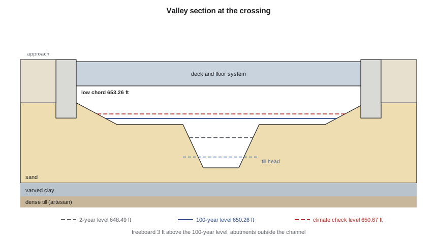
The borings, B-11 at the south abutment and B-12 at the north, broadly confirm the model. Below the abutment ground surface, there is about 10 ft of loose to medium dense sand, then varved clay with undrained strength of about 1,050 to 1,250 psf from field vane tests to about 33 ft, then dense till. The piezometer in the till at B-12 shows a head about 4 ft below the abutment ground surface, which means it is roughly 1 ft above the creek bed. Any excavation or open hole into the till near the creek could flow. This finding shapes the foundation choice in lesson 6.
Hydrology and hydraulics
The master plan hydrologic model gives the flows at the site directly, and Anika confirms that the model's subcatchment boundaries put the crossing just below the confluence with a small tributary, so the full flow passes the site. The 100-year flow is slightly less than at the Ridgeway culvert because the site is upstream. The climate-check flow, as in the master plan, is the 100-year flow increased by a third.
For water levels, a full hydraulic model is not needed at the concept stage, because a clear-span bridge set well above the floodplain barely changes the flow. A normal-depth calculation in a compound channel, with separate roughness for the main channel and the vegetated floodplain, gives water levels that the team can later compare with the master plan's model. The calculation divides the section into the main channel and the floodplain, computes the conveyance of each with Manning's equation, and finds the depth at which their sum carries the design flow.
Here k is 1.0 in SI units and 1.486 in US customary units, n is Manning's roughness, A the flow area, R the hydraulic radius and S the slope. The floodplain, with long grass and willow shrubs, is far rougher than the channel, and once the flow leaves the banks the depth rises slowly because the wide floodplain adds conveyance quickly.
# Water levels at the trail bridge site from a compound channel, Manning's equation
import math
UNITS = "US"
SI = UNITS == "SI"
k = 1.0 if SI else 1.486                      # Manning constant
if SI:
    b, z, nc = 4.0, 2.0, 0.040                 # main channel bottom width (m), side slope, roughness
    bank = 1.2                                 # bankfull depth (m)
    fp_w, nf = 30.0, 0.070                     # total floodplain width (m) and roughness
    S = 0.0040
    flows = {"2-year": 5.5, "100-year": 16.0, "climate check (+33 %)": 21.3}
    bed = 196.80                               # channel bed elevation (m)
    u = "m"
else:
    b, z, nc = 13.0, 2.0, 0.040
    bank = 4.0
    fp_w, nf = 100.0, 0.070
    S = 0.0040
    flows = {"2-year": 195.0, "100-year": 565.0, "climate check (+33 %)": 750.0}
    bed = 645.70                               # ft
    u = "ft"
def Q(y):
    """Discharge for depth y using separate main channel and floodplain subsections."""
    if y <= bank:
        A = (b + z * y) * y; P = b + 2 * y * math.sqrt(1 + z * z)
        return k / nc * A * (A / P) ** (2 / 3) * math.sqrt(S)
    A1 = (b + z * bank) * bank + (b + 2 * z * bank) * (y - bank)
    P1 = b + 2 * bank * math.sqrt(1 + z * z)
    A2 = fp_w * (y - bank); P2 = fp_w + 2 * (y - bank)
    q1 = k / nc * A1 * (A1 / P1) ** (2 / 3) * math.sqrt(S)
    q2 = k / nf * A2 * (A2 / P2) ** (2 / 3) * math.sqrt(S)
    return q1 + q2
def depth(q):
    lo, hi = 0.01, 10.0 if SI else 33.0
    for _ in range(80):
        mid = (lo + hi) / 2
        lo, hi = (mid, hi) if Q(mid) < q else (lo, mid)
    return (lo + hi) / 2
levels = {}
for name, q in flows.items():
    y = depth(q); levels[name] = bed + y
    print(f"{name:24s} Q = {q:7.1f} {'m3/s' if SI else 'cfs'}   depth {y:5.2f} {u}   level {bed + y:8.2f} {u}")
fb = 1.0 if SI else 3.0
low_chord = levels["100-year"] + fb
print(f"\nMinimum low chord = 100-year level + {fb:g} {u} = {low_chord:.2f} {u}")
gap = low_chord - levels["climate check (+33 %)"]
print(f"Clearance above the climate-check level: {gap:.2f} {u}")2-year Q = 195.0 cfs depth 2.79 ft level 648.49 ft 100-year Q = 565.0 cfs depth 4.56 ft level 650.26 ft climate check (+33 %) Q = 750.0 cfs depth 4.97 ft level 650.67 ft Minimum low chord = 100-year level + 3 ft = 653.26 ft Clearance above the climate-check level: 2.58 ft
The 100-year level at the site is 650.26 ft, so the minimum low chord is 653.26 ft. The climate-check level is 650.67 ft, only about 0.4 ft higher than the 100-year level, because the extra flow spreads across the floodplain. That leaves about 2.6 ft of clearance above the climate-check level, more than enough to pass floating ice and debris, which the master plan reports as the main hazard in spring.
Worked problem
Conveyance of the main channel at bankfull
The main channel has a bottom width of 13 ft, side slopes of 2 horizontal to 1 vertical, a bankfull depth of 4.0 ft, n of 0.040 and a slope of 0.0040. What flow does it carry at bankfull?
Show solution
- \[A = (13 + 2 \times 4.0) \times 4.0 = 84.0\ \text{ft}^2\]
- \[P = 13 + 2 \times 4.0 \sqrt{5} = 30.9\ \text{ft}, \quad R = 2.72\ \text{ft}\]
- \[Q = \frac{1.486}{0.040} \times 84.0 \times 2.72^{2/3} \times 0.0040^{1/2} = 384\ \text{cfs}\]
Answer: The channel alone carries about two thirds of the 100-year flow at bankfull; the rest spills onto the floodplain.
Two checks keep the simple calculation honest. Kenji compares its 100-year depth with the master plan model's result at the nearest cross-section and finds them within 0.1 ft, which is close enough for a concept. He also runs the calculation with the floodplain roughness raised and lowered by 20 %, because n is a judgment. The 100-year level changes by a few centimeters, far less than the freeboard. The detailed design will still use the master plan model, extended to include the bridge, for the permit application.
Other data: utilities, habitat and use
The utility locate finds a buried telecommunications duct along the north side of Ridgeway Road and an overhead distribution line on the south side. The duct sets the depth of the trailhead lot's storm connection; the overhead line matters for the crane that will lift the truss, as lesson 10 discusses. The fisheries survey from the master plan confirms that the creek supports a cold-water fishery, which brings in-water work timing windows and a strong preference for keeping all permanent works out of the channel. The tree survey finds two large old trees near the north approach, which the team decides to keep by shifting the path alignment a few meters.
The two-week trail count, done with an inexpensive infrared counter on the informal trail, records about 180 crossings on a typical weekday and up to 450 on a fine weekend day, with peaks after school and in the early evening. That is light traffic for a multi-use path, but it is enough to justify the 3.6 yard width for passing and confirms that the bridge will be well used. Counts are cheap, and they turn an argument about whether anyone will use the bridge into a number.
One gap the team decides not to fill is a full environmental baseline study. The master plan's fisheries and habitat surveys are recent, cover the reach, and were accepted by the regulators for the culvert replacement downstream. Repeating them would cost money and a field season for little new information. Instead, the team asks the city's environmental planner to confirm that the regulators will accept the master plan data for a bridge that keeps all works out of the channel, and records the answer. Choosing not to collect data is a legitimate decision, as long as it is a decision and not an oversight.
From data to design values
The last step is to record the design values that the rest of the project will use, with their sources: the flows and levels, the ground layers and strengths, the piezometric head, the bank lines and the tree positions. Each goes into the criteria memo as a numbered item, so that a reviewer can trace any number in a calculation back to the field work and the people who did it.
Practical points
- Inventory inherited data and mark each item as usable, to be confirmed, or missing.
- Drill at the foundations you will actually build, even when a ground model exists nearby.
- Measure the artesian head; do not assume it.
- Test a simple hydraulic calculation against the detailed model and for sensitivity to roughness.
- Count the users; it is cheap and it settles arguments.
Common mistakes
MistakeUsing a ground model from boreholes far from the structure.
InsteadDrill at each foundation location and confirm the layers and groundwater.
MistakeTaking a three-year-old survey of a moving creek at face value.
InsteadResurvey the banks and sections at the crossing.
MistakePicking one roughness value and moving on.
InsteadRun a sensitivity check; roughness is a judgment.
MistakeRecording design values without sources.
InsteadNumber each value in the criteria memo with its source and date.
Summary and key terms
- Inherited data saves time but must be judged for location, date and purpose.
- A data inventory marks each dataset as usable, to be confirmed or missing.
- New borings at both abutments confirm sand over varved clay over artesian till, with the till head about 1 ft above the creek bed.
- The 100-year level is 650.26 ft and the minimum low chord 653.26 ft.
- The climate-check level is only slightly above the 100-year level because the floodplain is wide.
- A trail count of about 180 weekday crossings justifies the bridge and its width.
- Data inventory
- A list of available data with source, date, accuracy and suitability.
- Compound channel
- A channel with a main section and a floodplain, analyzed as separate subsections.
- Conveyance
- The flow-carrying capacity of a channel section, proportional to A R^(2/3) / n.
- Normal depth
- The depth of uniform flow for a given discharge, slope and roughness.
- Piezometric head
- The level to which groundwater rises in a piezometer, a measure of its pressure.
- Artesian condition
- Groundwater pressure in a confined layer high enough to rise above the layer.
- Low chord
- The lowest point of a bridge superstructure.
- Timing window
- The period when in-water work is allowed, set to protect fish at sensitive life stages.
Practice problems
Work each problem on paper first, then reveal the answer to check.
The till head at B-12 is 4 ft below the ground at the boring, which is at 650.7 ft. What is its elevation, and how does it compare with the creek bed at 645.70 ft?
Show answer
646.7 ft, about 1 ft above the creek bed.
Why does the climate-check level barely exceed the 100-year level at this site?
Show answer
Above bankfull the wide floodplain adds conveyance quickly, so extra flow raises the level only a little.
What would change if the floodplain roughness were 20 % higher?
Show answer
Water levels would rise slightly; the team's check shows a few centimeters, well within the freeboard.
Why drill new boreholes when a ground model exists?
Show answer
The nearest boreholes are far away and on higher ground; layer depths and groundwater pressure at the abutments control the foundation design.
Lesson quiz · 5 questions
Score 60% or more to complete this lesson.
Create a free account to save your progress, take quizzes and earn a certificate.