
CIV-499 · Lesson 7 of 12 · 19 min
Hydraulics, stormwater and environmental approvals
The bridge spans the floodplain, so its effect on the creek is small. The rest of the project is a different matter. A trailhead parking lot, a plaza and a paved path add a quarter of a hectare of hard surface beside a cold-water stream, and every square meter of it sheds more water, faster and dirtier, than the meadow it replaces. This lesson checks the bridge's hydraulic effect, designs stormwater management for the new surfaces, and assembles the environmental approvals the project needs. Permits are not paperwork that follows design; they set conditions that change the design and the schedule, and a team that discovers them late redesigns under pressure.
The bridge and the flood
A clear-span bridge with its low chord above the water level causes almost no backwater: the flow area under it is the same as the natural section. The team confirms this with the master plan's hydraulic model, extended to include the bridge as a deck with no piers and abutments outside the floodplain. The computed rise in the 100-year water level upstream of the crossing is less than 0.03 ft, effectively zero. That result matters for the floodplain approvals, which in both countries look closely at any rise in flood levels on neighboring property.
The approaches are another question. The south approach climbs from the Ridgeway Road path to the deck on a low embankment of 5 ft at its highest point, and part of it crosses the edge of the regulated floodplain. Amara shifts the alignment so that the embankment stays outside the 100-year flood line except for its last few meters, where it meets the abutment, and the volume of fill placed below the flood level is balanced by a small cut on the opposite side of the trail. Balanced cut and fill keeps the floodplain's storage unchanged, which both the conservation authority and the floodplain ordinance look for.
Stormwater from the new surfaces
The trailhead has a 32-space parking lot with a drive aisle, a small plaza with bicycle racks and a map board, and the first section of paved path. Together with landscaped strips, the drainage area is about 0.62 acre. The rational method estimates the peak flow from a small area for a design storm:
with Q in cfs, i the rainfall intensity in in./h for a duration equal to the time of concentration, and A in acres. For the 100-year storm the runoff coefficient is increased by 25 %, capped at 1.0, because a saturated surface sheds more of a large storm. The intensities come from the city's design storm curves.
# Trailhead stormwater: rational-method peaks before and after, and bioretention sizing
UNITS = "US"
SI = UNITS == "SI"
if SI:
    areas = {"parking lot and drive aisle": (0.135, 0.90), "trail and plaza": (0.060, 0.85), "landscaped strips": (0.055, 0.30)}
    pre_C = 0.25
    i5, i100 = 62.0, 128.0                       # mm/h for a 10-minute storm, city IDF (illustrative)
    wq_depth = 25.0                              # mm captured from the hard surfaces
    pond_depth, media_depth, void = 0.20, 0.75, 0.35
    k_clay = 2.0                                 # mm/h native infiltration (varved clay)
    peak = lambda C, i, A: C * i * A / 360      # m3/s with A in ha
    au, qu, vu = "ha", "m3/s", "m3"
else:
    areas = {"parking lot and drive aisle": (0.334, 0.90), "trail and plaza": (0.148, 0.85), "landscaped strips": (0.136, 0.30)}
    pre_C = 0.25
    i5, i100 = 2.45, 5.05                        # in./h
    wq_depth = 1.1                               # in., MIDS performance goal
    pond_depth, media_depth, void = 0.65, 2.5, 0.35   # ft
    k_clay = 0.08                                # in./h
    peak = lambda C, i, A: C * i * A            # cfs with A in acres
    au, qu, vu = "ac", "cfs", "ft3"
A = sum(a for a, _ in areas.values())
Cw = sum(a * c for a, c in areas.values()) / A
print(f"Drainage area {A:.3f} {au}, composite C after {Cw:.2f} (before {pre_C:.2f})")
for name, i, cf in (("5-year", i5, 1.0), ("100-year", i100, 1.25)):
    # cf: frequency factor for rare storms, with C capped at 1.0
    q0, q1 = peak(min(1.0, pre_C * cf), i, A), peak(min(1.0, Cw * cf), i, A)
    print(f"{name:9s} peak before {q0:.3f} {qu}, after {q1:.3f} {qu} ({q1 / q0:.1f} times)")
hard = sum(a for n, (a, c) in areas.items() if c > 0.5)
if SI:
    wqv = wq_depth / 1000 * hard * 10000
else:
    wqv = wq_depth / 12 * hard * 43560
store_per_area = pond_depth + media_depth * void
area_cell = wqv / store_per_area
print(f"Water quality volume from hard surfaces: {wqv:.0f} {vu}")
print(f"Storage per unit area: ponding {pond_depth:g} + media {media_depth:g} x {void:g} = {store_per_area:.2f} {'m' if SI else 'ft'}")
print(f"Bioretention footprint needed: {area_cell:.0f} {'m2' if SI else 'ft2'}")
hours = store_per_area * (1000 if SI else 12) / k_clay
print(f"Drawdown by infiltration alone: {hours:.0f} h -> underdrain required (target 48 h or less)")Drainage area 0.618 ac, composite C after 0.76 (before 0.25) 5-year peak before 0.379 cfs, after 1.145 cfs (3.0 times) 100-year peak before 0.975 cfs, after 2.949 cfs (3.0 times) Water quality volume from hard surfaces: 1925 ft3 Storage per unit area: ponding 0.65 + media 2.5 x 0.35 = 1.52 ft Bioretention footprint needed: 1262 ft2 Drawdown by infiltration alone: 229 h -> underdrain required (target 48 h or less)
Development roughly triples the peak flow, from a meadow with a runoff coefficient of 0.25 to a mostly paved site at 0.76. The quantities are small in absolute terms, because the site is small, but the creek is sensitive and the city's standards require new development to control both the quality and the quantity of its runoff.
Bioretention
The team uses a bioretention cell, a planted depression with engineered soil media over a stone reservoir and an underdrain, beside the parking lot. It treats runoff by filtering it through the media and by uptake in the plants and soil, and it holds back part of each storm. Minnesota's Minimal Impact Design Standards, used by the city, set a performance goal of retaining 1.1 in. of runoff from new impervious surfaces where site conditions allow, with alternatives where they do not. The water quality volume is about 1,925 ft³. With 0.65 ft of ponding and 2.5 ft of media at 35 % voids, each square foot of cell stores about 1.52 ft of water, so the cell needs about 1,260 ft².
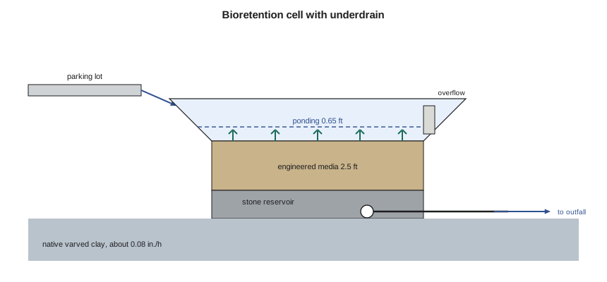
The native soil is the varved clay, which infiltrates at about 0.08 in./h. At that rate the cell would take more than 200 hours to drain by infiltration alone, far longer than the 48 hours the design guidance allows, after which plants suffer and mosquitoes breed. The cell therefore has a perforated underdrain in its stone reservoir, with a small orifice that releases the stored water over about a day and a half. Because infiltration is restricted by clay soils, the site qualifies for the MIDS flexible treatment options, and a filtering practice with an underdrain that removes phosphorus and solids is an accepted alternative to full retention.
Worked problem
Checking the cell's storage
A cell of 1,300 ft² has 0.65 ft of ponding and 2.5 ft of media at 35 % voids. How much runoff can it hold, and does it meet the 1,925 ft³ target?
Show solution
- \[\text{storage depth} = 0.65 + 2.5 \times 0.35 = 1.525\ \text{ft}\]
- \[V = 1300 \times 1.525 = 1983\ \text{ft}^3 \geq 1925\ \text{ft}^3\]
Answer: The 1,300 ft² cell holds the water quality volume with a small margin; the drawings show 1,300 ft².
Larger storms pass the cell through an overflow inlet set at the ponding level, which connects to a short storm sewer and an outfall to the creek downstream of the bridge. The outfall has a riprap apron to dissipate energy and is set above the low-flow channel so that its construction needs no work in the water. Because the site is small and close to the creek outlet, the city does not require peak flow control for the 100-year storm here; the master plan showed that detaining small sites near the outlet can make downstream peaks worse by delaying their runoff until the upstream flood arrives. This is a site-specific judgment that the team checks with Anika and records with its reasons.
A bioretention cell works only if someone looks after it. The team's operations and maintenance notes, which go to the parks department with the drawings, cover the first two growing seasons, when plants need watering and weeding; removal of sediment from the inlet after the spring melt, when sand from winter sanding of the lot arrives; inspection after large storms to check that the overflow and underdrain are clear; and replacement of the top layer of media if water stands in the cell for more than two days after a storm. The planting plan uses native species that tolerate both wet spring conditions and dry late summers, and avoids anything that would need mowing. The city's parks staff asked for this level of detail at the design review; they have inherited stormwater practices before that nobody told them how to maintain.
The team also considers what goes into the runoff. Parking lots collect oil, metals from brake and tire wear, sand and winter salt. Bioretention removes much of the solids and the substances attached to them, but it does not remove dissolved chloride, and salt can damage the plants and pass straight through to the creek. The design therefore asks the city to minimize salt on the trailhead lot, using a winter maintenance plan that favors plowing and sand, and the planting plan uses salt-tolerant species near the inlet.
Environmental approvals
The team builds a permit table early in the design, with each approval, the agency, what triggers it, what it requires and how long it takes. The table drives the schedule in lesson 9, because the longest approvals can take months.
| Approval | Agency | Trigger | Main conditions |
|---|---|---|---|
| Section 404 permit | US Army Corps of Engineers | fill below the ordinary high water mark, such as riprap | likely covered by a nationwide permit; Section 106 and endangered species reviews |
| Section 401 water quality certification | Minnesota Pollution Control Agency | a federal permit for discharge to waters | conditions on turbidity and work methods |
| Public waters work permit | Minnesota DNR | work in a public water or designated trout stream | timing restrictions; no rise in flood levels |
| Construction stormwater permit | Minnesota Pollution Control Agency | disturbance of one acre or more | erosion and sediment control plan; inspections |
| Floodplain and shoreland permits | City of Duluth | work in the mapped floodplain and shoreland zone | no rise in flood levels; setbacks; vegetation |
The Corps permit is the one that could change the design most. Riprap at the abutment slopes and the outfall apron, if any of it lies below the ordinary high water mark, is fill that needs a Section 404 permit, though a project of this size is likely to be covered by a nationwide permit if it meets that permit's conditions. The federal permit in turn brings consultation on historic and cultural resources under Section 106 and an endangered species review. The team keeps all riprap above the ordinary high water mark where it can, which may avoid the 404 trigger altogether, and records the alternative. Because Kestrel Creek is a designated trout stream, the DNR permit sets timing restrictions on work near the water.
Erosion and sediment control is a condition of every approval and a design product in its own right. The drawings include a staged plan: silt fence along the floodplain edge before any stripping, a turbidity curtain at the outfall, stabilized construction entrances, and seeding and erosion blankets on the approach slopes within days of final grading. The specifications require inspection after every significant rain and a named person responsible for maintaining the controls.
Practical points
- Confirm with a model that a clear-span bridge causes no meaningful rise in flood levels.
- Balance any fill below the flood level with cut nearby to keep floodplain storage.
- Size bioretention for the water quality volume, and add an underdrain on clay.
- Build the permit table early; it drives the design and the schedule.
- Design out in-water work wherever possible; it simplifies every approval.
Common mistakes
MistakeAssuming infiltration practices work on any soil.
InsteadCheck the native infiltration rate; on clay, use an underdrain and a filtering design.
MistakeDetaining every small site's peak flow by habit.
InsteadNear a watershed outlet, detention can worsen downstream peaks; check with the watershed model.
MistakeTreating permits as a step after design.
InsteadList approvals at the start; their conditions shape the design.
MistakePlacing an outfall in the low-flow channel.
InsteadSet it above the channel with an energy dissipator to avoid in-water work.
Summary and key terms
- The clear-span bridge raises the 100-year level by less than 0.03 ft.
- Approach fill below the flood level is balanced by nearby cut.
- Development roughly triples the peak runoff from the trailhead area.
- A 1,300 ft² bioretention cell treats the water quality volume; an underdrain is needed on the clay.
- The outfall sits above the low-flow channel with a riprap apron.
- A permit table lists each approval, its trigger, conditions and timing, and drives the schedule.
- Backwater
- A rise in water level upstream of an obstruction to flow.
- Rational method
- A peak-flow formula, Q = C i A, for small drainage areas.
- Runoff coefficient
- The fraction of rainfall that becomes runoff from a surface.
- Bioretention
- A planted depression with engineered media that filters and holds runoff.
- Underdrain
- A perforated pipe beneath a stormwater practice that drains water the native soil cannot absorb.
- Water quality volume
- The runoff volume a practice must capture and treat.
- Ordinary high water mark
- The line on a bank set by the usual high level of a watercourse, used to define regulated areas.
- Erosion and sediment control
- Measures that keep soil on site and out of waterways during construction.
Practice problems
Work each problem on paper first, then reveal the answer to check.
An area of 0.62 acre has C = 0.76 and a 5-year intensity of 2.45 in./h. What is the peak flow?
Show answer
0.76 × 2.45 × 0.62 = 1.15 cfs.
How much bioretention area is needed for 2,400 ft³ with 1.525 ft of storage depth?
Show answer
2,400 / 1.525 = 1,574 ft².
Why does the cell need an underdrain?
Show answer
The clay infiltrates so slowly that the cell would not drain within 48 hours.
Why might detaining the 100-year peak from this site be counterproductive?
Show answer
Near the outlet, delaying a small site's runoff can make it coincide with the upstream flood peak.
Lesson quiz · 5 questions
Score 60% or more to complete this lesson.
Create a free account to save your progress, take quizzes and earn a certificate.