
PET-210 · Lesson 8 of 12 · 19 min
Stratigraphic and combination traps
The Tamarack Lake field has no dome at all. Its Cardium sandstone dips gently southwest, like the rest of the beds in this part of the basin, and yet the oil does not leak updip to the northeast. Ethan finds out why on a cross-section built from well logs: northeast of the field, the clean shoreface sand thins and passes into shale over a few kilometres. 'The rock itself is the trap,' Nadia says. 'The sand ends, the shale seals it, and the oil has nowhere to go.' Stratigraphic traps like this are harder to find than structures, but they hold enormous volumes of oil, and in mature basins they are where much of the remaining conventional oil lies.
What makes a stratigraphic trap
A stratigraphic trap is formed by changes in the rock layers themselves rather than by later deformation. The reservoir loses its porosity or permeability, or ends against a seal, because of the way the rocks were deposited, eroded or altered. Some tilt or dip is still needed, because oil must rise against the seal, but there is no closed structure. The term was popularized by the American geologist A. I. Levorsen, who argued in the 1930s that many large fields lay in such traps and would be found only by studying the rocks, not just mapping structures. His prediction has proved right in basin after basin.
Stratigraphic traps fall into three broad groups. Depositional traps form where a reservoir body is surrounded by impermeable rock as it was laid down: a sand that pinches out into shale, a river channel cut into mud, a reef enclosed by basin shales, or a turbidite lobe buried in deep-water mud. Unconformity traps form where a reservoir was tilted, eroded and then covered by an impermeable layer, so that the reservoir is truncated beneath the unconformity; or where a reservoir lies on top of an unconformity in a low. Diagenetic traps form where cementation or dissolution changes porosity after deposition, for example where porosity is plugged updip by cement or where it is enhanced only in a dolomitized zone.
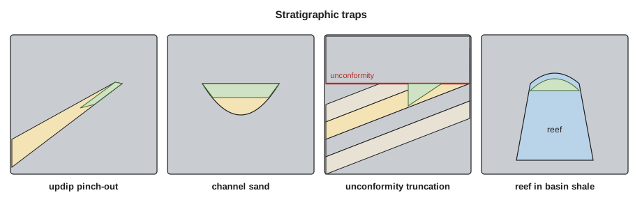
| Trap type | How it forms | Typical examples |
|---|---|---|
| Updip pinch-out | A reservoir thins and passes into shale up the dip | Shoreface and delta-front sands |
| Channel fill | A channel sand is cut into and surrounded by mud | Incised valley fills; deepwater channels |
| Reef or buildup | A carbonate buildup is buried by basin shale | Devonian reefs of Alberta; Permian reefs |
| Truncation trap | Tilted reservoirs are eroded and sealed by an unconformity | Prudhoe Bay, Alaska; many Mississippian fields |
| Onlap trap | Reservoirs lap onto an unconformity surface and are sealed above | Basin margin sands |
| Diagenetic trap | Cement plugs porosity updip, or dissolution creates it locally | Cemented sandstones; hydrothermal dolomites |
| Combination trap | Structure and stratigraphy together close the trap | Faulted or folded pinch-outs; salt flank traps |
Unconformities
An unconformity is a surface of erosion or non-deposition that separates rocks of different ages: a gap in the record. An angular unconformity, where tilted older layers are cut off beneath flat younger ones, records folding, uplift and erosion before deposition resumed. A disconformity separates parallel layers with an erosion surface between them. Unconformities create traps in two ways. Reservoirs below them may be truncated and sealed if the rock deposited on the unconformity is impermeable, and reservoirs above them may fill valleys or onlap onto the old surface.
Unconformities can also improve reservoirs. Exposure at the surface lets fresh water dissolve carbonates, producing karst and vuggy porosity, and weathering can leach unstable grains from sandstones. North America's largest oil field, Prudhoe Bay on the North Slope of Alaska, discovered in 1968, is a combination trap in which tilted Triassic sandstones are truncated beneath a Lower Cretaceous unconformity and sealed by the shale above it, on the crest of a broad structural high.
Sequence stratigraphy
Finding stratigraphic traps requires predicting where reservoirs and seals will be. Sequence stratigraphy, developed largely at Exxon in the 1970s from seismic data, provides the framework. It divides the basin fill into sequences, packages of genetically related layers bounded by unconformities or their equivalent surfaces in deep water. Each sequence records one cycle of relative sea level, the combined effect of global sea level and local subsidence. Within a sequence, systems tracts describe the deposits formed during different parts of the cycle.
During a fall of relative sea level, rivers cut valleys across the exposed shelf, and sand bypasses the shelf to build lowstand fans and wedges in deep water. As sea level begins to rise, the valleys fill with sand and mud, and the transgressive systems tract steps landward, with shoreline sands overlain by marine shales. The maximum flooding surface, the time of deepest water across the shelf, is marked by a widespread, often organic-rich shale that makes an excellent seal and sometimes a source rock. As the rise slows, highstand deposits build seaward again in coarsening-upward packages, until the next fall cuts a new sequence boundary.
This framework predicts trap locations. Incised valley fills, cut during the fall and filled during the rise, form ribbon-shaped reservoirs encased in shale. Lowstand turbidite fans form isolated deep-water reservoirs below shelf-edge mudstones. Transgressive sands are thin but sealed above by the flooding shale. Highstand shorefaces pinch out landward into coastal plain mudstones. Geologists identify these packages on seismic and in well logs, then search for places where a reservoir is sealed updip.
Sequence stratigraphy also changes how geologists correlate wells. Traditional correlation joins similar-looking rock layers from well to well, but sandstones of different ages can look alike, and the same layer can change from sand to shale. Correlating surfaces of the same age, such as flooding surfaces and sequence boundaries, gives a more realistic picture of how reservoirs connect. Lesson 9 shows how this is done on well logs.
The Cardium of Alberta is a celebrated example. Its sandstones and conglomerates, once thought to be offshore bars, are now interpreted as shoreface deposits formed during falls and stillstands of relative sea level, truncated and reworked by erosion surfaces and sealed by marine shale as the sea rose again. Mapping those surfaces explains why the reservoir appears in elongated belts parallel to the old shoreline, and why some belts sit kilometres offshore of others, recording shorelines that moved back and forth across the basin.
Deep-water stratigraphic traps
Some of the largest stratigraphic traps found in recent decades lie in deep water. Turbidite channels and lobes, described in Lesson 2, are often encased in thick slope and basin muds that seal them on all sides. Where a sand-rich lobe thins and pinches out up the slope, or a channel fill is cut off by later erosion, a trap forms without any structural closure. Along the margins of the Atlantic, off West Africa, Brazil and Guyana, several giant fields discovered since 2000 are of this kind, found largely by recognizing the sand bodies directly on seismic data from their amplitudes. Such traps are attractive because they can be very large, but they carry particular risks: the updip seal may be thin or sandy, and the sands may be broken into compartments by muddy channel fills and slumps, so appraisal wells and pressure data are needed early to confirm that the volumes connect.
Combination traps
Many traps owe their closure to both structure and stratigraphy, and are called combination traps. A sandstone that pinches out across the flank of an anticline, a reservoir truncated against a fault where the fault provides closure in one direction and a facies change in another, or a sand body draped over a buried reef are all combinations. Salt-flank traps, where upturned sands are sealed by salt on one side and by shale above, combine structure with stratigraphic geometry. In mature basins, combination traps are often the largest remaining targets, because pure structures were drilled first.
Finding subtle traps
Stratigraphic traps are called subtle because they do not show up as obvious highs on structure maps. Finding them requires dense well control, detailed core and log studies to build facies maps, and seismic data processed to show changes in rock properties rather than just structure. Seismic attributes such as amplitude, frequency and impedance, discussed in Lesson 10, can reveal channels, porosity belts and pinch-outs. Even so, stratigraphic prospects carry more risk than structures: the seal is often the reservoir's own lateral facies change, which may be leaky, and predicting exactly where a sand ends is difficult.
# Channel sand bodies in a cross-section: chance that a vertical well hits sand, and connectivity
import random
random.seed(7)
L, H = 10_000.0, 40.0      # section length and interval thickness, m
T = 5.0                    # channel thickness, m
WT = 60                    # width-to-thickness ratio
W = WT * T                 # channel width, m

def build(p):
    chans, sand = [], 0.0
    while sand / (L * H) < p:
        x, z = random.uniform(-W, L), random.uniform(0, H - T)
        chans.append((x, z)); sand += W * T
    return chans

def overlap(a, b):
    return a[0] < b[0] + W and b[0] < a[0] + W and a[1] < b[1] + T and b[1] < a[1] + T

def stats(chans):
    wells = [i * L / 200 for i in range(200)]
    hit = sum(any(x <= w <= x + W for x, _ in chans) for w in wells) / len(wells)
    parent = list(range(len(chans)))
    def find(i):
        while parent[i] != i: parent[i] = parent[parent[i]]; i = parent[i]
        return i
    for i in range(len(chans)):
        for j in range(i + 1, len(chans)):
            if overlap(chans[i], chans[j]): parent[find(i)] = find(j)
    sizes = {}
    for i in range(len(chans)): sizes[find(i)] = sizes.get(find(i), 0) + 1
    return hit, max(sizes.values()) / len(chans)

print(f"channel width {W:.0f} m for a {T:.0f} m thick channel (W/T = {WT})")
print("sand proportion   wells hitting sand   share of channels in largest connected body")
for p in (0.10, 0.20, 0.30, 0.40, 0.50):
    hit, conn = stats(build(p))
print(f" {p:4.0%} {hit:5.0%} {conn:5.0%}")channel width 300 m for a 5 m thick channel (W/T = 60)
sand proportion wells hitting sand share of channels in largest connected body
10% 56% 7%
20% 80% 6%
30% 92% 9%
40% 94% 13%
50% 98% 9%The program uses a width-to-thickness ratio typical of single river channels, which is commonly between about 30 and 100, and places channels randomly in a cross-section to estimate how often a vertical well would hit sand and how many channels join into one connected body. The hit rate rises quickly with the proportion of channel sand, but connectivity in a single section stays poor even at 50 percent sand, because a channel can only touch neighbours in the plane of the section. In three dimensions channels can join from any side, and studies based on percolation theory find that they begin to link into a continuous network at a sand proportion of roughly 30 percent. Below that, many sand bodies are isolated and each may need its own well. That is one reason horizontal wells, which cross many channels, have transformed development of channelized reservoirs.
Worked problem
Is the pinch-out sealed?
Ethan maps the Cardium sandstone thinning northeastward: 6 m net sand at well A, 3 m at well B, 2 km farther northeast, and 0 m at well C, 2 km beyond B. The beds dip southwest at 4 m per km. Above the sand lies 15 m of marine shale. Well B tested oil; well C found only shale. Where is the likely updip limit of the trap, and how high is the oil column if the oil-water contact in well A is 5 m below the sand top there?
Show solution
- Net sand thins linearly by 3 m every 2 km from A to B; extrapolating, it reaches zero about 4 km from A, at or just before well C. The pinch-out lies about 4 km northeast of A.
- From A to the pinch-out, the beds rise 4 m/km × 4 km = 16 m.
- The oil-water contact at A is 5 m below the sand top, so the oil column from the contact to the pinch-out is 16 + 5 = 21 m.
- The shale above and northeast of the pinch-out must hold that column; 15 m of marine shale normally can, as Lesson 6 showed.
Answer: A trap about 4 km long in the dip direction with a column of roughly 21 m. The width along strike must still be mapped from more wells and seismic.
Common mistakes
MistakeLooking only for closed structures.
InsteadMany large fields lie in stratigraphic and combination traps; in mature basins they hold much of what remains.
MistakeCorrelating wells by similar-looking rock alone.
InsteadCorrelate time surfaces, such as flooding surfaces and sequence boundaries; sands of different ages can look alike.
MistakeAssuming a lateral facies change always seals.
InsteadSilty or thin shales may leak. Seal quality must be assessed as for any trap.
MistakeUsing vertical-well hit rates for channelized reservoirs.
InsteadLow sand proportions mean many misses and poor connectivity; horizontal wells and seismic attributes reduce the risk.
Summary and key terms
- Stratigraphic traps form from depositional, erosional or diagenetic changes in the rocks, not from later deformation.
- Types include pinch-outs, channel fills, reefs, truncation and onlap traps at unconformities, and diagenetic traps.
- Unconformities create truncation traps below and onlap traps above, and can enhance porosity by weathering.
- Sequence stratigraphy divides the basin fill into sequences and systems tracts tied to relative sea level, predicting reservoirs and seals.
- Combination traps use both structure and stratigraphy and are major targets in mature basins.
- Subtle traps need dense well control, facies maps and seismic attributes, and carry higher seal and geometry risk.
- Stratigraphic trap
- A trap formed by changes in rock type, porosity or layering rather than by deformation.
- Pinch-out
- The updip end of a reservoir where it thins to zero and passes into a seal.
- Unconformity
- A surface of erosion or non-deposition representing a gap in the geological record.
- Sequence
- A package of related strata bounded by unconformities or equivalent surfaces.
- Maximum flooding surface
- The surface marking the deepest water in a sequence, often a widespread shale.
- Incised valley fill
- Sediment filling a valley cut during a fall in relative sea level.
- Combination trap
- A trap whose closure depends on both structure and stratigraphy.
Practice problems
Work each problem on paper first, then reveal the answer to check.
Why was Levorsen's idea of the stratigraphic trap so important for exploration?
Show answer
It showed that large fields could exist without closed structures, directing exploration toward facies, unconformities and diagenesis.
Which systems tract surface makes an excellent regional seal, and why?
Show answer
The maximum flooding surface, because it is marked by widespread marine shale deposited when water was deepest.
A channel sand is 8 m thick. Using a width-to-thickness ratio of 60, estimate its width.
Show answer
8 × 60 = 480 m.
Give an example of a famous combination trap and its two components.
Show answer
Prudhoe Bay: tilted Triassic sandstones truncated beneath a Cretaceous unconformity (stratigraphic) on a broad structural high (structural).
Lesson quiz · 5 questions
Score 60% or more to complete this lesson.
Create a free account to save your progress, take quizzes and earn a certificate.