
PET-210 · Lesson 12 of 12 · 20 min
The Western Canada Sedimentary Basin
At the end of the term, Nadia asks Ethan to present the regional picture to Prairie Crest's managers: one basin, seen whole, with every idea from the course in its place. The Western Canada Sedimentary Basin is a wedge of sedimentary rock that thickens from a feather edge on the Canadian Shield in northeastern Alberta and Saskatchewan to more than 5 kilometres beneath the Rocky Mountain foothills. It extends from southwestern Manitoba through Saskatchewan and Alberta into northeastern British Columbia and the southern Northwest Territories, covering about 1.4 million square kilometres. It holds almost all of Canada's conventional and unconventional oil and gas, and it has been producing for more than a century.
Two basins in one
As Lesson 1 described, the basin had two lives. From the Cambrian to the Jurassic, it was the western margin of the ancient North American continent, a passive margin and platform where warm shallow seas laid down mostly carbonates, evaporites and shales. Reefs and carbonate banks grew repeatedly, especially in the Devonian, and restricted basins between them accumulated organic-rich muds. From the Late Jurassic onward, terranes colliding with the western edge of the continent built the Cordillera, and their weight bent the crust down to form a foreland basin. Rivers draining the new mountains filled it with sand, mud and gravel, building a thick wedge of Jurassic to Paleogene clastic rocks that thins eastward.
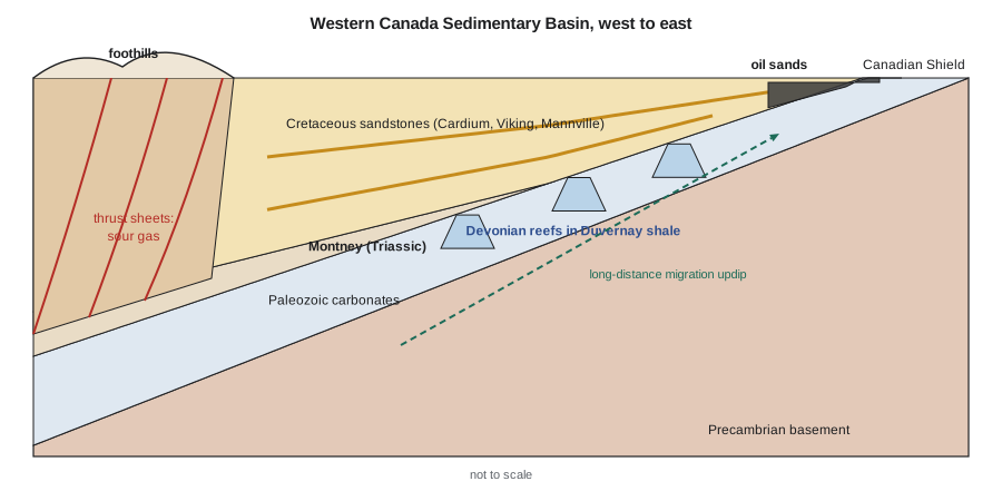
The two stages explain the basin's petroleum geography. Paleozoic carbonates and their source rocks lie at depth throughout the basin and rise eastward. The foreland wedge supplied the burial that matured them, mostly in the Late Cretaceous and Paleogene, when sediments shed from the rising mountains buried the western basin deeply. Since then, uplift and erosion have removed one to three kilometres of rock in many areas, cooling the source rocks and stopping most generation. Oil and gas generated during deep burial migrated eastward and upward along the gently dipping layers for great distances.
The petroleum systems
| System or play | Source | Reservoir | Trap | Main products |
|---|---|---|---|---|
| Devonian reefs | Duvernay and equivalent basinal shales | Leduc, Swan Hills and other reefs and platforms | Buried reefs sealed by Ireton and other shales | Light oil and gas |
| Mississippian carbonates | Exshaw and Bakken shales | Pekisko, Elkton, Turner Valley and others | Foothills thrust folds; unconformity truncations | Sour gas, oil |
| Montney | Montney organic-rich siltstone itself and Triassic shales | Montney siltstone and fine sandstone | Continuous accumulation; some conventional traps updip | Gas, condensate, light oil |
| Duvernay | Duvernay shale itself | Duvernay shale and carbonate | Continuous accumulation | Light oil, condensate, gas |
| Cretaceous clastics | Jurassic and Cretaceous marine shales | Cardium, Viking, Glauconitic, Mannville and others | Stratigraphic pinch-outs, channels, shorefaces | Light and medium oil, gas |
| Oil sands | Mostly migrated oil from deep sources | McMurray and other Lower Cretaceous sands | Updip edge of the basin; biodegradation | Bitumen |
The Devonian reef system is the textbook example. Leduc No. 1 in 1947 opened a trend of reefs that grew on carbonate platforms in a warm sea and were later surrounded by the basinal Duvernay and Ireton shales, which sourced and sealed them. Reefs such as Redwater, Swan Hills, Golden Spike and Rainbow became giant and major fields. In the foothills, Mississippian and Devonian carbonates folded and thrust during mountain building hold large volumes of sour gas, rich in hydrogen sulfide, which required special processing and safety measures from the beginning.
The Cretaceous foreland wedge holds hundreds of stratigraphic traps. The Cardium, Viking and Mannville sandstones were deposited in shoreface, deltaic and valley-fill environments along the shifting margin of the Western Interior Seaway, which at times stretched from the Arctic to the Gulf of Mexico. The Tamarack Lake field is one of many Cardium pools; the largest, Pembina, discovered in 1953, covers more than 3,000 square kilometres and was the largest conventional oil field in Canada by area. Waterflooding and, more recently, horizontal wells with multistage fracturing have extended the life of these pools for decades.
Unconventional resources
The basin's most recent revolution came from its source rocks and tight reservoirs. The Triassic Montney Formation, a thick, organic-bearing siltstone extending across northeastern British Columbia and northwestern Alberta, is one of the largest gas and liquids resources in North America. Its maturity increases westward, so it produces light oil in the east, condensate-rich gas in the middle and dry gas in the west, the same zoning by maturity described in Lesson 5. It now supplies a large share of Canada's natural gas, often estimated at around half, and is a main feed for liquefied natural gas exports from the British Columbia coast. The Devonian Duvernay shale, which sourced the reef oil, is itself drilled for light oil and condensate where it is mature, notably in the Kaybob and East Shale Basin areas.
The oil sands of the Athabasca, Cold Lake and Peace River areas hold the largest share of Canada's oil, and Canada's proven oil reserves are among the largest in the world because of them. They formed when vast quantities of oil migrated updip to the eastern edge of the basin and were degraded by bacteria into bitumen, as Lesson 6 explained. Shallow deposits are mined; deeper ones are produced in place by injecting steam, most commonly by steam-assisted gravity drainage. Production reached a record of about 3.5 million barrels per day in 2026 according to industry forecasts, making the oil sands the largest single source of Canadian oil.
# Hydrocarbons in place per section (one square mile, 2.59 km2) for three Western Canada plays
SECTION = 2.59e6                       # m2
# name: (net thickness m, porosity, hydrocarbon saturation, fluid, volume factor, recovery factor)
plays = {
    'Cardium shoreface oil': (6.0, 0.14, 0.75, 'oil', 1.25, 0.25),
    'Duvernay oil window':   (40.0, 0.06, 0.70, 'oil', 1.60, 0.07),
    'Montney gas':           (120.0, 0.05, 0.75, 'gas', 0.0040, 0.15),
}
print(f"{'play':24s}{'HCPV, 10^6 m3':>15s}{'in place':>22s}{'recoverable':>22s}")
for name, (h, phi, sh, fluid, b, rf) in plays.items():
    hcpv = SECTION * h * phi * sh
    inplace = hcpv / b                 # oil: stock-tank m3; gas: standard m3
    if fluid == 'oil':
        a, r = inplace * 6.29 / 1e6, inplace * rf * 6.29 / 1e6
        unit = 'million bbl'
    else:
        a, r = inplace * 35.31 / 1e9, inplace * rf * 35.31 / 1e9
        unit = 'bcf'
print(f"{name:24s}{hcpv / 1e6:15.2f}{a:13.1f} {unit:8s}{r:13.1f} {unit:8s}")play HCPV, 10^6 m3 in place recoverable Cardium shoreface oil 1.63 8.2 million bbl 2.1 million bbl Duvernay oil window 4.35 17.1 million bbl 1.2 million bbl Montney gas 11.65 102.9 bcf 15.4 bcf
The program compares hydrocarbons in place per square mile section, a common unit in Western Canada because of the land survey system, for a Cardium pool, a Duvernay oil-window location and a Montney gas location. The unconventional plays hold far more hydrocarbon per section, because they are thick and continuously charged, but recover a much smaller fraction of it. That trade-off between abundance and recovery drives the economics of each play.
Worked problem
Screening a Montney section
Ethan screens a Montney location in the condensate window: net thickness 120 m, porosity 5 percent, gas saturation 75 percent, and gas formation volume factor 0.0040 reservoir m³ per standard m³. A section is 2.59 km². Estimate the free gas in place per section and the recoverable gas if wells recover 15 percent.
Show solution
- Hydrocarbon pore volume = A h φ S_g = 2.59 × 10⁶ m² × 120 m × 0.05 × 0.75 = 11.66 × 10⁶ m³.
- Gas in place = HCPV / B_g = 11.66 × 10⁶ / 0.0040 = 2.91 × 10⁹ standard m³.
- In cubic feet: 2.91 × 10⁹ × 35.31 = 103 billion cubic feet per section.
- Recoverable at 15 percent: 0.44 × 10⁹ m³, about 15 billion cubic feet.
Answer: About 2.9 billion m³ (100 billion cubic feet) of free gas in place per section, of which perhaps 15 percent is recoverable with current wells. Adsorbed gas and condensate would add to these figures.
The southeast: the Williston corner and heavy oil
The basin's southeastern corner, in southern Saskatchewan and southwestern Manitoba, overlaps the northern edge of the Williston Basin, an intracratonic sag that subsided slowly through the Paleozoic. There the rocks and plays differ from those of Alberta. The Devonian-Mississippian Bakken Formation, a thin sandwich of organic-rich shales around a silty dolomite, produces light oil from horizontal wells in southeastern Saskatchewan, and Mississippian carbonates such as the Midale and Frobisher beds hold large conventional pools sealed beneath the sub-Mesozoic unconformity, the classic unconformity traps of Lesson 8. The Weyburn field, discovered in 1954, became one of the best-known carbon dioxide floods in the world, injecting carbon dioxide captured at a coal gasification plant in North Dakota and storing it in the reservoir while recovering more oil.
Farther north, along the Alberta-Saskatchewan border near Lloydminster, Lower Cretaceous Mannville sands hold heavy oil, partly biodegraded like the oil sands but light enough to flow slowly at reservoir temperature. Operators produce it cold, allowing sand to come into the well with the oil to open wormhole channels, or with steam and horizontal wells. The range of oil from light Bakken crude to heavy Lloydminster oil and Athabasca bitumen within one basin is a direct record of how far each charge migrated and how much it was degraded on the way.
Exploration history and data
Few basins in the world are as densely drilled and as openly documented. Western Canada has hundreds of thousands of wells, and well logs, core, drill stem tests and production data are filed with the regulators and made available to the industry after a confidentiality period. Core from many wells is stored at the Core Research Centre of the Alberta Energy Regulator in Calgary and at the Saskatchewan subsurface geological laboratory in Regina, where geologists can examine rock from almost any formation. This public record is why a small company such as Prairie Crest can map a play regionally before buying land, and why many discoveries in the basin have come from reinterpreting old data with new ideas, as Nadia did when she reviewed the Leduc dome.
The basin's future will be shaped by more than oil and gas production. Its deep saline aquifers, particularly in the Devonian and Cambrian sections, are being evaluated and used for carbon storage, as in the Quest project, which has stored carbon dioxide from an oil sands upgrader in the Basal Cambrian sandstone since 2015. The same knowledge of reservoirs, seals and traps that found the oil now decides where carbon dioxide can be stored safely, the subject of later courses in the program.
Ethan closes his regional section with a map exercise the managers can follow. He plots the depth to the top of the Duvernay, its vitrinite reflectance and the outlines of the Leduc reefs on one sheet. The reefs sit along the edge of the basinal shale; the shale passes westward from immature through the oil window into gas; and the Cretaceous pools lie above and east of it all, charged by oil that rose through the section. One map, he points out, shows source, migration path and trap together, which is the whole idea of a petroleum system.
A mature basin that keeps renewing itself
The Western Canada Sedimentary Basin illustrates every theme of this course. Its history as a passive margin and foreland basin set out its rocks. Its source rocks matured in a burial pulse in the Late Cretaceous and Paleogene, the critical moment for most of its systems. Its traps range from reefs and thrust folds to subtle shoreface pinch-outs, and its oil has been preserved, degraded or locked in tight rock depending on where it ended up. Each generation of explorers has found new resources by understanding a different part of the petroleum system, from the reefs to the Cretaceous sandstones to the source rocks themselves.
For Prairie Crest, the study ends with a portfolio rather than a single prospect: infill and step-out locations along Cardium shoreface trends, the risked Leduc dome west of the field, and a small position in the Duvernay oil window that could be tested later. Ethan presents the volumes as ranges and the chances of success honestly, and Lena's economic model ranks them. The geology does not make the decisions, but it frames them, which is the role of a petroleum geologist in any company.
Common mistakes
MistakeThinking of the basin as one uniform petroleum province.
InsteadIt contains distinct systems of different ages, from Devonian reefs to Triassic siltstones and Cretaceous sandstones.
MistakeAssuming present depth reflects maximum burial.
InsteadOne to three kilometres of section have been eroded in many areas; maturity reflects the deeper past.
MistakeTreating the oil sands as a conventional reservoir.
InsteadBitumen does not flow at reservoir conditions; it must be mined or heated in place.
MistakeComparing in-place volumes without recovery factors.
InsteadUnconventional plays hold more per section but recover a much smaller fraction.
Summary and key terms
- The Western Canada Sedimentary Basin is a wedge thickening westward to more than 5 km, covering about 1.4 million km².
- It was a Paleozoic passive margin with carbonates and evaporites, and a Jurassic-to-Paleogene foreland basin filled with clastics.
- Burial in the Late Cretaceous and Paleogene matured most source rocks; later uplift eroded one to three kilometres.
- Key systems include Devonian reefs sourced by the Duvernay, foothills thrust gas, Cretaceous stratigraphic traps such as the Cardium, and the oil sands.
- The Montney and Duvernay are major unconventional plays zoned by maturity.
- The basin has renewed itself repeatedly as understanding of its petroleum systems has grown.
- Western Canada Sedimentary Basin
- The sedimentary basin beneath Alberta, Saskatchewan, southwestern Manitoba and northeastern British Columbia.
- Western Interior Seaway
- The Cretaceous inland sea that stretched across North America.
- Montney Formation
- A Triassic siltstone that is one of North America's largest gas and liquids resources.
- Duvernay Formation
- A Devonian organic-rich shale that sourced reef oil and is now produced directly.
- Oil sands
- Sandstones saturated with bitumen, biodegraded oil too viscous to flow without heat or dilution.
- Sour gas
- Natural gas containing hydrogen sulfide.
- SAGD
- Steam-assisted gravity drainage, a method of producing bitumen in place with paired horizontal wells.
Practice problems
Work each problem on paper first, then reveal the answer to check.
Why are Paleozoic rocks in the eastern part of the basin generally less mature than those in the west?
Show answer
The foreland wedge thins eastward, so eastern rocks were never buried as deeply or heated as much.
Which Devonian shale both sourced reef oil and became a target itself?
Show answer
The Duvernay.
Explain why the Montney produces oil in the east and dry gas in the west.
Show answer
Its maturity increases westward with deeper past burial, moving from the oil window to the gas window.
Name two production methods used for the oil sands.
Show answer
Surface mining for shallow deposits and steam-assisted gravity drainage for deeper ones.
Lesson quiz · 5 questions
Score 60% or more to complete this lesson.
Create a free account to save your progress, take quizzes and earn a certificate.