
PET-210 · Lesson 2 of 12 · 20 min
Sedimentary processes and depositional environments
Ethan's first task is to describe a core from a Tamarack Lake field well. Laid out in boxes on the long tables of the core laboratory, nine metres of rock show a story he cannot yet read: fine grey mudstone at the base, then thin sandy layers that thicken upward, then clean, well-sorted sandstone with gently tilted laminations, capped by a pebbly layer and dark shale. Nadia walks along the boxes. 'This is a shoreline,' she says. 'The sea was getting shallower, the beach was building outward, and then something changed and the sea flooded back in.' Reading rocks this way, as the record of the place where they formed, is the core skill of petroleum geology, because the place decides the shape, size and quality of the reservoir.
From weathering to deposition
Sedimentary rocks begin as weathering breaks older rocks down. Physical weathering, such as frost wedging and abrasion, breaks rock into fragments. Chemical weathering dissolves some minerals and alters others: feldspar turns to clay, while quartz, which resists chemical attack, survives as sand grains. Rivers, wind, glaciers and ocean currents then carry the products away. The transported pieces, from clay through silt, sand and gravel, are called clastic or siliciclastic sediment. Dissolved ions travel to lakes and the sea, where organisms and chemical reactions turn them into carbonate rocks and evaporites such as salt and anhydrite.
Grain size is the first thing a geologist records. The Udden-Wentworth scale divides sediment into clay (finer than 1/256 mm), silt (1/256 to 1/16 mm), sand (1/16 to 2 mm) and gravel (coarser than 2 mm), with sand further split into very fine to very coarse. The size of grains a current can move depends on its speed: a fast river carries gravel, a slow one only mud. When the current slows, the largest grains drop first. This is why grain size changes in predictable ways across a delta or down a beach, and why it records the energy of the environment.
Stokes's law gives the settling speed of a small sphere of diameter d and density ρs falling through a fluid of density ρf and viscosity μ. It holds for silt and clay, where flow around the grain stays smooth; larger sand grains fall more slowly than the law predicts because turbulence adds drag. The law explains why clay settles only in very quiet water, such as lakes, lagoons and the deep sea, while sand drops out wherever currents slacken.
# Settling speed of grains in still water from Stokes's law
RHO_S, RHO_F = 2650.0, 1000.0     # quartz grain and fresh water, kg/m3
MU, G = 1.0e-3, 9.81              # water viscosity Pa.s at about 20 C, gravity m/s2

def stokes(d_mm):
    d = d_mm / 1000.0
    return (RHO_S - RHO_F) * G * d * d / (18 * MU)

def nice(seconds):
    for unit, s in (("days", 86400), ("hours", 3600), ("minutes", 60)):
        if seconds >= s: return f"{seconds / s:.1f} {unit}"
    return f"{seconds:.0f} seconds"

print("grain              diameter (mm)  speed (mm/s)   time to fall 5 m")
for name, d in (("fine clay", 0.0005), ("coarse clay", 0.002), ("silt", 0.02), ("very fine sand", 0.08)):
    v = stokes(d)
print(f"{name:18s} {d:10.4f} {1000 * v:12.4f} {nice(5 / v):>16s}")grain diameter (mm) speed (mm/s) time to fall 5 m fine clay 0.0005 0.0002 257.4 days coarse clay 0.0020 0.0036 16.1 days silt 0.0200 0.3597 3.9 hours very fine sand 0.0800 5.7552 14.5 minutes
The output makes the point vividly. A clay particle takes weeks or even months to fall five metres, so any current at all keeps it moving; a very fine sand grain falls the same distance in about a quarter of an hour, and coarser sand much faster still. Clay therefore accumulates only where water is still for long periods, and the presence of a thick mudstone tells a geologist that the setting was calm.
Sorting, rounding and sedimentary structures
Besides size, geologists describe how uniform the grains are and how they are arranged. A well-sorted sand has grains of nearly the same size, typical of beaches and windblown dunes where waves or wind have winnowed the finer material away. A poorly sorted sediment, such as a glacial deposit or a debris flow, mixes clay to boulders. Sorting matters to engineers because well-sorted sands have the highest porosity and permeability: no small grains fill the spaces between the large ones. Rounding records distance of travel: grains carried far are smoothed; those deposited near their source stay angular.
Sedimentary structures are features formed during or just after deposition, and they are the best clues to the environment. Ripples and cross-bedding form as currents push sand along in migrating bedforms; the direction the cross-beds dip shows which way the current flowed. Hummocky cross-stratification forms under storm waves on the shelf. Graded beds, coarse at the base and fining upward, record a single waning flow such as a turbidity current. Mud cracks show the sediment dried out at the surface. Burrows and tracks, called trace fossils, show where animals lived and how much oxygen the water held.
Geologists also watch how grain size changes upward through a section. A coarsening-upward package, mud passing up into sand, typically records a shoreline or delta building out into deeper water, so that sandier, shallower deposits settle on top of muddier, deeper ones. A fining-upward package, sand passing up into mud, often records a river channel filling and being abandoned. On a gamma-ray log, which reads high in shale and low in clean sand, coarsening-upward packages look like a funnel and fining-upward packages like a bell. Lesson 9 uses these shapes to correlate wells.
Depositional environments
A depositional environment is a place with a particular set of physical, chemical and biological conditions, such as a river channel, a beach or the deep-sea floor. Each produces a distinctive combination of rock types, structures, fossils and geometries, called a facies. Walther's law, one of the most useful ideas in the field, states that facies found stacked vertically in a continuous sequence were once side by side on the surface. As a shoreline moves, the environments move with it and lay their deposits on top of each other. Reading a vertical core therefore reveals a map.
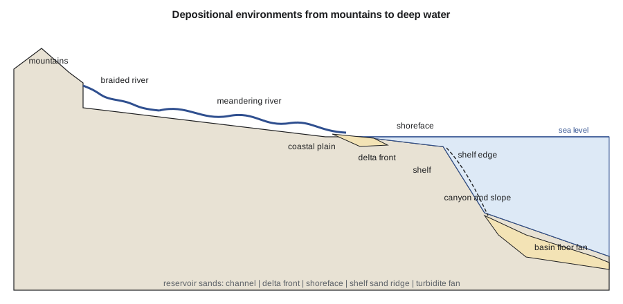
| Environment | Typical deposits | Reservoir geometry | Petroleum importance |
|---|---|---|---|
| Alluvial fan and braided river | Coarse, poorly sorted gravel and sand | Sheets and wedges near mountain fronts | Moderate; quality varies sharply |
| Meandering river | Channel sands fining upward, floodplain muds | Sinuous ribbons and point bars, often isolated | Common reservoirs; connectivity is the challenge |
| Delta | Coarsening-upward mouth bars, distributary channels | Lobes and fingers fanning seaward | Very important: many giant fields |
| Shoreface and barrier island | Clean, well-sorted, coarsening-upward sands | Long strips parallel to the old coast | Excellent quality; many Cretaceous fields |
| Shelf | Muds with storm sand beds, sand ridges | Thin sheets and isolated ridges | Seals and some reservoirs |
| Deepwater fan | Turbidites: graded sands and muds | Channels and lobes on the basin floor | Major in the Gulf of Mexico and offshore Brazil |
| Eolian dune | Very well-sorted sand with large cross-beds | Broad sheets and dune fields | Excellent quality where preserved |
| Lake and restricted marine | Organic-rich laminated mud | Thin, widespread layers | Source rocks |
The Cardium illustrates why environment matters so much. Its best sandstones and conglomerates formed at the shoreface, where waves winnowed sand into long, narrow bodies parallel to an ancient coastline that ran roughly northwest to southeast across Alberta. A field such as Pembina, discovered in 1953, follows that trend for tens of kilometres. Knowing the trend lets geologists predict where the next sand body will be, and it tells engineers that wells placed along the trend will stay in good rock longer than wells drilled across it.
Worked problem
Reading a coarsening-upward core
Ethan logs the core from the Tamarack Lake field well: from 1,548 to 1,545 m, grey mudstone with thin silt laminae; 1,545 to 1,542 m, interbedded very fine sandstone and mudstone with hummocky cross-stratification; 1,542 to 1,540 m, clean fine sandstone with low-angle laminations; 1,540 to 1,539.6 m, pebble conglomerate; above, dark marine shale. Interpret the environments and identify the best reservoir interval.
Show solution
- The basal mudstone with silt laminae formed below storm wave base on the offshore shelf, in quiet water.
- Interbedded sandstone and mudstone with hummocky cross-stratification records the lower shoreface or offshore transition, where storms swept sand out over the mud.
- Clean sandstone with low-angle laminations is the upper shoreface to foreshore, where constant wave action sorted the sand. This is the best reservoir.
- The pebble layer and the marine shale above record a flooding surface: the sea deepened, waves reworked the top of the sand into a lag, and mud covered it. The shale is the seal.
- Walther's law: the vertical stack, deeper facies under shallower ones, records a shoreline building seaward.
Answer: A prograding shoreface capped by a transgressive lag and shale. The clean sandstone from 1,542 to 1,539.6 m, about 2.4 m thick, is the main reservoir, and the shale above seals it.
Deep water: turbidity currents and fans
Not all sand stays near the shore. On steep continental slopes, sediment piles up until an earthquake, a storm or simple overloading triggers a slide. The slide mixes with water into a turbidity current, a dense, fast-moving cloud of sediment that races down submarine canyons at speeds of several metres per second and can travel hundreds of kilometres across the basin floor. As it slows, it drops its load: coarse sand first, then finer sand, silt and finally mud, building the graded bed called a turbidite. Thousands of these events, stacked over millions of years, build submarine fans of channels, levees and sheet-like lobes.
Turbidite fans hold some of the largest oil fields discovered in the last fifty years, in the deep Gulf of Mexico, offshore Brazil and West Africa. Their sands can be clean and thick, but they are threaded with mud layers that may divide a reservoir into compartments, and channels can be cut and filled many times. Predicting how well the sand bodies connect is one of the hardest problems in deepwater development, and it relies heavily on seismic images, discussed in Lesson 10.
Describing core in practice
A core description follows a routine. The geologist works from the base upward, recording rock type, grain size, sorting, sedimentary structures, fossils, burrowing intensity, colour, oil staining and fractures, and plotting them on a graphic log whose width increases with grain size. Photographs under white and ultraviolet light record the core before it is sampled, because oil fluoresces under ultraviolet and shows which layers hold it. Plugs are then drilled for porosity and permeability tests at regular intervals, often every 30 centimetres, and the results are placed beside the description so that rock quality can be tied to facies. That link between facies and measured properties is what lets a geological model predict reservoir quality between wells.
From sediment to rock: diagenesis
Once buried, sediment becomes rock through diagenesis, the physical and chemical changes that happen at the temperatures and pressures of the upper few kilometres of the crust. Compaction squeezes grains together and drives out water. Cementation precipitates new minerals, such as quartz, calcite or clay, in the pore spaces and binds the grains. Dissolution can remove unstable grains or cement and create new pores. Together, these processes usually reduce porosity and permeability with depth, but dissolution and early cements that prop the grains apart can preserve unusually good porosity deep in a basin.
Diagenesis is one reason two sandstones deposited in the same environment can perform very differently. A beach sand buried quickly beneath a thick shale may keep much of its porosity; the same sand exposed to circulating groundwater may be cemented solid with calcite. Petrographers study thin slices of rock under the microscope to work out which cements formed when, and that sequence, called the paragenesis, helps predict reservoir quality in places no well has yet reached. Lessons 3 and 4 return to diagenesis for sandstones and carbonates.
Common mistakes
MistakeAssuming all sandstones are good reservoirs.
InsteadSorting, clay content and cementation vary widely. Poorly sorted or heavily cemented sands may have little usable porosity.
MistakeReading a vertical core without thinking about lateral equivalents.
InsteadWalther's law says vertically stacked facies once lay side by side. The core implies a map.
MistakeTreating shale as a single uniform rock.
InsteadShales range from organic-rich source rocks to silty seals with storm beds, and each records a different setting.
MistakeIgnoring the orientation of reservoir bodies.
InsteadChannels, shorefaces and deepwater lobes have strong trends. Wells placed along the trend stay in reservoir longer.
Summary and key terms
- Weathering produces clastic grains and dissolved ions; transport sorts grains by size and density.
- The Udden-Wentworth scale classifies grains as clay, silt, sand and gravel; Stokes's law explains why clay settles only in quiet water.
- Sorting, rounding and sedimentary structures record the energy and setting of deposition.
- A facies is a body of rock with characteristics that reflect one environment; Walther's law links vertical sequences to lateral maps.
- Each environment produces reservoirs with a characteristic shape: ribbons in rivers, lobes in deltas, strips along shorelines, fans in deep water.
- Diagenesis, through compaction, cementation and dissolution, turns sediment into rock and changes its porosity and permeability.
- Clastic sediment
- Sediment made of fragments of older rocks and minerals, such as sand and mud.
- Sorting
- How uniform the grain sizes in a sediment are; well-sorted sands make the best reservoirs.
- Cross-bedding
- Inclined layers formed by migrating ripples or dunes, showing the current direction.
- Facies
- A body of rock with features that reflect the environment where it formed.
- Walther's law
- Facies stacked vertically in a continuous sequence formed side by side on the surface.
- Turbidite
- A graded bed deposited by a turbidity current, a dense flow of sediment-laden water.
- Diagenesis
- Physical and chemical changes that turn buried sediment into rock.
Practice problems
Work each problem on paper first, then reveal the answer to check.
A sand grain 0.1 mm across and a clay particle 0.002 mm across settle in water. By what factor does the sand settle faster if Stokes's law held for both?
Show answer
Speed scales with d², so (0.1/0.002)² = 50² = 2,500 times faster.
A core shows sandstone at the base fining upward into siltstone and then mudstone with root traces. What environment is likely?
Show answer
A river channel filling and being abandoned, topped by floodplain deposits with plant roots.
Why are shoreface sandstones usually better reservoirs than river channel sandstones of the same grain size?
Show answer
Constant wave action sorts shoreface sand well and removes clay, and shoreface bodies are long and continuous; channel sands are often less sorted and more isolated.
State Walther's law and explain why it matters for prediction.
Show answer
Facies stacked in a continuous vertical sequence were once side by side. A vertical core therefore tells you which environments lay next to each other, which predicts where reservoir sands go laterally.
Lesson quiz · 5 questions
Score 60% or more to complete this lesson.
Create a free account to save your progress, take quizzes and earn a certificate.