
PET-210 · Lesson 1 of 12 · 20 min
Geologic time, basins and the petroleum geologist
Nadia Petrov has a new assignment. Prairie Crest wants to know whether the oil in its Tamarack Lake field is the last good pool in the area or the first of several, and the managers have asked the geoscience team for a regional study before they buy more land. Ethan Cardinal, the engineer-in-training who started with Lena in PET-200, has been loaned to the project. On his first morning Nadia unrolls a cross-section of the Western Canada Sedimentary Basin that runs from the Rocky Mountain foothills to the Canadian Shield and says, 'Everything we will do this term starts here. Before you can find oil, you have to know how old the rocks are, how they got where they are, and what the basin did to them.' This course follows that study from the rocks themselves to the full basin.
Petroleum geology is the branch of geology that deals with the origin, migration, accumulation and recovery of oil and natural gas. PET-200 introduced the petroleum system in one lesson; this course takes each part of it in turn. Engineers need this knowledge because every number they use, from porosity and permeability to the size of a trap and the pressure in a reservoir, comes from rocks that were deposited, buried, heated and deformed over tens or hundreds of millions of years. An engineer who understands why a reservoir is shaped the way it is will place wells better, predict surprises sooner and talk to geologists as a colleague. CIV-241 Engineering Geology covers rocks and minerals for civil works; here the focus is on sedimentary rocks and the processes that make and keep petroleum.
Deep time
The Earth is about 4.54 billion years old. Geologists divide that time into eons, eras, periods and epochs, a scale built first from the order of rock layers and their fossils and later fixed in absolute years by radiometric dating. Most of the world's oil and gas comes from rocks of the last 550 million years, the Phanerozoic eon, when complex life flourished and left abundant organic matter. The Phanerozoic is split into three eras: the Paleozoic (about 539 to 252 million years ago), the Mesozoic (252 to 66 million years ago) and the Cenozoic (66 million years ago to the present). Each era is divided into periods, such as the Devonian, the Cretaceous and the Paleogene, whose names appear constantly in petroleum work.
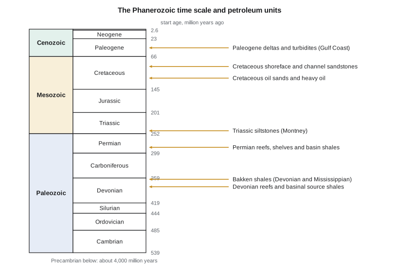
In the Western Canada Sedimentary Basin, the important petroleum rocks span almost the whole Phanerozoic. Devonian reefs at Leduc and Swan Hills held the discoveries that started the modern Alberta industry in 1947. The Devonian Duvernay shale sourced much of that oil and is now a target itself. The Triassic Montney siltstone is one of the largest gas and liquids resources in North America. The Cretaceous Cardium sandstones, about 90 million years old, hold the Tamarack Lake field and many fields like it, and the Cretaceous oil sands of the Athabasca region hold most of Canada's oil.
Two kinds of age matter. Relative age tells which rock came first, using a few simple principles: in undisturbed layers, younger rocks lie on top of older ones (superposition); layers were laid down horizontally and later tilted (original horizontality); a fault or intrusion is younger than the rocks it cuts (cross-cutting relationships); and fossils change in a known order through time (faunal succession). Absolute age, in years, comes from radioactive decay. Volcanic ash beds within sedimentary sequences are especially valuable because their minerals can be dated precisely, pinning the age of the sediments above and below.
Petroleum geologists use fossils every day. Microfossils, such as foraminifera, pollen, spores and tiny algae called dinoflagellates, survive drilling and appear in the rock cuttings that come up with the mud. A biostratigrapher at the well site can identify them within hours and tell the drilling team which formation the bit has reached, often before the logs are run. Index fossils, species that lived for a short time over a wide area, let geologists match rocks of the same age between wells hundreds of kilometres apart.
Sedimentary basins
Almost all petroleum is found in sedimentary basins, regions where the Earth's crust subsided over long periods and filled with sediment, often several kilometres thick. Subsidence creates the space for sediment, called accommodation, and burial provides the heat that turns organic matter into oil. Basins form in a few main tectonic settings, and each setting tends to produce a recognizable pattern of rocks, structures and petroleum.
| Basin type | How it forms | Typical petroleum character | Examples |
|---|---|---|---|
| Rift | Continental crust stretches and breaks into fault blocks | Lake or restricted marine source rocks; tilted fault-block traps | North Sea grabens, East African rifts |
| Passive margin | Crust cools and sinks after a continent splits; sediment builds a wedge toward the ocean | Thick deltas and deepwater sands; salt structures | Gulf of Mexico, offshore Brazil, Scotian margin |
| Foreland | Weight of a mountain belt bends the crust down beside it | Thick wedge thinning away from mountains; long-distance migration; foothills thrust traps | Western Canada, Rocky Mountain basins |
| Intracratonic | Slow, broad sagging in a continental interior | Roughly circular basins; layered shales, carbonates and evaporites | Williston, Michigan, Illinois basins |
| Strike-slip | Crust pulls apart at bends in large horizontal faults | Small, deep, fast-filling basins; complex faults | Los Angeles and Ventura basins |
The Western Canada Sedimentary Basin is a good example of a basin that changed over time. Through the Paleozoic it was a passive margin on the western edge of ancient North America, where warm shallow seas built reefs and carbonate platforms. From the Jurassic onward, mountain building to the west loaded the crust and turned it into a foreland basin, which filled with sand and mud shed from the rising Rockies. The two stages explain why the deeper rocks are mostly carbonates and the shallower rocks mostly sandstones and shales.
Sea level, subsidence and sediment supply
The rocks that fill a basin record a running contest between three things: how fast the floor subsides, how much sediment rivers and the sea deliver, and how the sea level rises and falls. When sea level rises faster than sediment arrives, the shoreline moves inland, a transgression, and marine shales spread over older beach and river sands. When sediment arrives faster, or sea level falls, the shoreline builds seaward, a regression, and sands advance over muds. Sequence stratigraphy, introduced in Lesson 8, uses these cycles to predict where reservoirs and seals will be.
Burial rates vary enormously. Some deep-sea muds accumulate at less than a millimetre per thousand years; the front of a major delta can receive tens of metres in the same time. As sediment is buried, it compacts: water is squeezed out, grains pack more tightly, and porosity falls. Fresh mud may be 60 to 80 percent water by volume; buried shale at 3,000 metres may have less than 10 percent porosity. Sand compacts less but also loses porosity with depth through compaction and cementation, as Lesson 3 explains. Geologists correct present-day thicknesses for compaction, a process called decompaction, to reconstruct how deep each layer was in the past.
This simple exponential law, often attributed to Athy, describes how porosity decreases with burial depth z. The surface porosity φ₀ and the compaction coefficient c are fitted for each rock type; for shale, typical values are φ₀ about 0.6 and c about 0.5 per kilometre, and for sandstone φ₀ about 0.45 and c about 0.3 per kilometre. The law is approximate, but it is the basis of the burial history models in Lesson 11.
# Porosity loss with depth (Athy's law) and decompaction of a buried shale bed
import math

PHI0, C = 0.60, 0.50          # shale: surface porosity, compaction coefficient per km

def phi(z_km):
    return PHI0 * math.exp(-C * z_km)

def solid(top, base):
    """Thickness of solid grains (km) in a layer between two depths, integrating 1 - phi."""
    return (base - top) - (PHI0 / C) * (math.exp(-C * top) - math.exp(-C * base))

print("depth (km)   porosity")
for z in (0, 0.5, 1, 2, 3, 4):
    print(f"{z:6.1f}       {phi(z):.2f}")

# A shale 100 m thick today, from 2.95 to 3.05 km
top, base = 2.95, 3.05
hs = solid(top, base)
# find the thickness the same grains had at the surface (top = 0), by bisection
lo, hi = hs, 1.0
for _ in range(60):
    mid = (lo + hi) / 2
    if solid(0, mid) < hs: lo = mid
    else: hi = mid
print(f"\nPresent thickness {1000 * (base - top):.0f} m, solid grains {1000 * hs:.1f} m")
print(f"Thickness when deposited: {1000 * lo:.0f} m ({lo / (base - top):.1f} times today)")depth (km) porosity 0.0 0.60 0.5 0.47 1.0 0.36 2.0 0.22 3.0 0.13 4.0 0.08 Present thickness 100 m, solid grains 86.6 m Thickness when deposited: 202 m (2.0 times today)
The program shows that a shale bed 100 metres thick today, buried at 3 kilometres, was about twice as thick when it was first deposited. Burial history models apply the same correction to every layer, which is why the present-day thicknesses on a cross-section are not the thicknesses the basin received.
Worked problem
Average burial rate of a sandstone
Ethan finds that the base of the Cardium sits at 1,550 m in a Tamarack Lake field well and that the rocks above it span about 90 million years. What is the average burial rate in metres per million years and millimetres per thousand years? Why might the real history differ from this average?
Show solution
- Rate = depth ÷ time = 1,550 m ÷ 90 million years = 17.2 m per million years.
- 1 m per million years = 1 mm per thousand years, so the rate is 17 mm per thousand years.
- The present depth also reflects erosion: in parts of Alberta one to two kilometres of younger rock were later stripped away, so the maximum burial was deeper and the rate during deposition higher than the average suggests.
Answer: About 17 m per million years on average, but real burial came in pulses and was followed by uplift and erosion, which matter for how hot the rocks became.
How petroleum geologists work
A petroleum geologist builds a picture of rocks that no one can see directly. The data come from outcrops where the same formations reach the surface, from seismic surveys, and from wells: cuttings, cores, wireline logs, pressure tests and samples of oil, gas and water. Each source has a different scale. A core shows grains a fraction of a millimetre across; a seismic survey resolves layers tens of metres thick over hundreds of square kilometres. Good interpretation joins the scales, using cores to calibrate logs and logs to calibrate seismic.
The work moves from regional to local. A basin study maps the major rock units, the source rocks and their maturity, and the main structural trends. A play is a group of prospects that share a source, reservoir, seal and trap style; the Montney and Bakken plays are examples. A prospect is a specific trap, mapped well enough to drill. Each stage narrows the area and raises the level of detail, and each produces maps and estimates that engineers use to plan wells and facilities.
Nadia lays out the plan for the Prairie Crest study. First, the team will review the rock types that make reservoirs and seals in the area, using cores from the company's own wells and public cores held at the provincial core research centre in Calgary, where the the AER stores samples from wells across the province. Next, it will map the source rocks and estimate how mature they are. Then it will map traps, using well logs and the seismic surveys the company has licensed, and finally it will place everything in time on a basin model. Ethan's job is to turn each step into numbers that the engineers can use: thicknesses, porosities, volumes and risks. 'Every map we make is a bet,' Nadia tells him, 'and your job is to know how much the bet is worth.'
Geologists also work with uncertainty. A prospect map is a model, not a photograph. The same seismic and well data can often be explained by several geological stories, and each story implies a different volume and risk. Good teams make their assumptions explicit, test them against new wells, and update quickly when the drill bit proves them wrong. Lesson 11 shows how these ideas come together in a basin model and an events chart.
Common mistakes
MistakeAssuming the present depth of a rock is the deepest it has ever been.
InsteadMany basins were uplifted and eroded. Maximum burial, not present depth, controls compaction and how hot a source rock became.
MistakeThinking older rocks are always deeper.
InsteadFaults, folds and thrusts can place older rocks above younger ones. Superposition applies only to undisturbed sequences.
MistakeTreating a basin as a single type forever.
InsteadMost basins changed setting through time, and each stage left different rocks and traps.
MistakeUsing present-day bed thicknesses for burial history.
InsteadThicknesses must be decompacted to estimate how deep each layer was in the past.
Summary and key terms
- Most petroleum comes from Phanerozoic rocks, the last 539 million years, divided into the Paleozoic, Mesozoic and Cenozoic eras.
- Relative age uses superposition, original horizontality, cross-cutting relationships and fossils; absolute age comes from radiometric dating, especially of volcanic ash beds.
- Sedimentary basins form by rifting, cooling of passive margins, loading by mountain belts, slow continental sagging or strike-slip motion.
- The basin fill records the balance of subsidence, sediment supply and sea level, producing transgressions and regressions.
- Sediments compact with burial; Athy's law describes porosity falling exponentially with depth.
- Petroleum geology moves from basin to play to prospect, joining data from cores, logs and seismic.
- Phanerozoic
- The eon of abundant complex life, from about 539 million years ago to the present.
- Superposition
- The principle that in undisturbed layers the younger rock lies on top.
- Sedimentary basin
- A region of long-term subsidence filled with sediment, the setting for nearly all petroleum.
- Foreland basin
- A basin formed beside a mountain belt as its weight bends the crust down.
- Transgression
- A landward shift of the shoreline as sea level rises relative to the land.
- Decompaction
- Restoring a buried layer to the thickness it had before compaction.
- Play
- A group of prospects that share a source rock, reservoir, seal and trap style.
Practice problems
Work each problem on paper first, then reveal the answer to check.
A shale has a porosity of 0.12 at 2.5 km. Using φ₀ = 0.60, what compaction coefficient c fits this point?
Show answer
c = ln(φ₀/φ)/z = ln(0.60/0.12)/2.5 = 1.609/2.5 = 0.64 per km.
Which is younger: a fault that cuts a Cretaceous sandstone, or the sandstone?
Show answer
The fault, by the principle of cross-cutting relationships.
Name the basin type that forms beside a growing mountain belt and give one example.
Show answer
A foreland basin, such as the Western Canada Sedimentary Basin or other Rocky Mountain basins.
Why are volcanic ash beds especially useful in sedimentary sequences?
Show answer
Their crystals can be dated radiometrically, giving an absolute age that brackets the sediments above and below.
Lesson quiz · 5 questions
Score 60% or more to complete this lesson.
Create a free account to save your progress, take quizzes and earn a certificate.